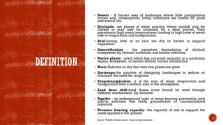
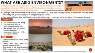
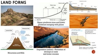
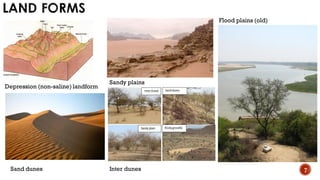
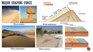
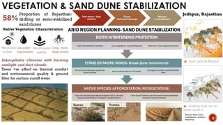
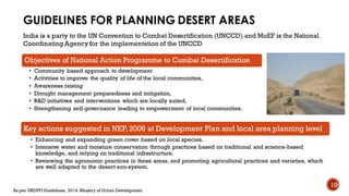
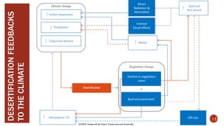
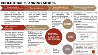
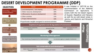
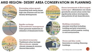
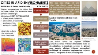
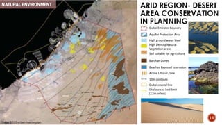
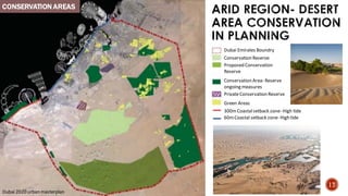
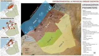
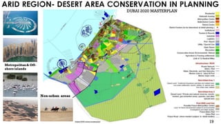
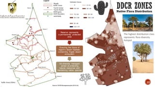
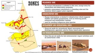
This presentation offers a comprehensive overview of conservation and sustainable development in arid regions. It covers the unique characteristics of arid environments, conservation efforts in desert ecosystems, and challenges like desertification. Key topics include guidelines for planning desert areas, the impact of desertification on climate change, and models for ecological planning. Initiatives like the Desert Development Programme (DDP) and the establishment of Desert Development and Climate Resilience (DDCR) zones are discussed. The presentation emphasizes the importance of balancing economic development with environmental preservation and calls for collaborative efforts among stakeholders and policymakers.
2. CONTENTS
1. Definitions
2. What are arid environments?
3. Desert ecosystem in India
4. Vegetation & sand dune stabilization
5. Guidelines for planning desert areas
6. Desertification feedbacks to the climate
7. Ecological planning model
8. Arid region- desert area conservation in planning
9. Desert development programme (ddp)
10.Cities in arid environments
• Environmental & physical urban growth
• DDCR zones
11. Arid region- desert area conservation in planning
3. DEFINITION
▪ Desert - A barren area of landscape where little precipitation
occurs and, consequently, living conditions are hostile for plant
and animal life.
▪ Drylands- are places of water scarcity, where rainfall may be
limited or may only be abundant for a short period. They
experience high mean temperatures, leading to high rates of water
loss to evaporation and transpiration.
▪ Arid-having little or no rain; too dry or barren to support
vegetation
▪ Desertification - the persistent degradation of dryland
ecosystems by climatic variations and human activities.
▪ Native plants - plant which has occurred naturally in a particular
region, ecosystem, or habitat without human introduction
▪ Xeric-Habitats so dry that very few plants can grow
▪ Xeriscape-the practice of designing landscapes to reduce or
eliminate the need for irrigation
▪ Evapotranspiration- it is the sum of water evaporation and
transpiration from a surface area to the atmosphere.
▪ Sand dune shift-sand dunes move forced by wind through
different mechanisms. Eg:saltation
▪ Aquifer - an underground layer of water-bearing permeable rock
and/or sediment that holds groundwater or unconsolidated
materials
▪ Pressure bearing capacity- the capacity of soil to support the
loads applied to the ground.
1
Source: Wildlife Habitat council- Desert project guidance
4. WHAT ARE ARID ENVIRONMENTS?
▪ Although arid environments have typical characteristics, they can be very diverse in character and are often
defined by the specific interplay of temperature and rainfall.
▪ They have different flora and fauna, geography and geology, resulting in different forms of human settlement.
Arid environments are characterized by a natural scarcity of fresh water and/or
precipitation. Just over 30% of the world’s land surface is classified as arid, a
figure that is set to increase with climate change.
• The climate is very hot & dry
• Day time temp. 40°C.&t
night can drop below 0°C.
• Hot deserts have two distinct
seasons: summer,
temperature between >40°C,
and winter >30°C.
CLIMATE
SOIL
• Desert soils are thin, sandy, rocky
& loose
• Desert soils are very dry-
absorb water quickly.
• This is due to the lack of rainfall.
Water evaporates, salts are left
behind- soil surface
2
Source- Desert region planning considerations-https://www.arup.com/-/media/arup/files/publications/c/citiesalive_aridenviros_arup.pdf
Source- Rethinking Cities in arid environments (AURP)
5. TYPES OF ARID ENVIRONMENTS
HYPER-ARID ZONES
• Extremely dry land
• Devoid of vegetation- few scattered shrubs
• Annual rainfall <100mm & irregular/absent for years
• Traditional human habaitation- nomadic pastoralism & no form of continuous
settlement
ARID ZONES
• Varied landscape planted with sparse native vegetation- annual & perennial
grasses, shrubs & small trees
• Rainfall varies in regularity- 200mm-300mm per annum
• Human habitation is characterized by pastoralism & limited settlement, historically
linked to irrigated farming land.
Semi-arid zones
• No typical land form, native vegetation- grasses, shrubs & date palm trees
• Annual rainfall >900mm
• This level of precipitation sustain agriculture & substantial urban development.
Source- Rethinking Cities in arid environments (AURP)
3
6. HOT DESERTS
• Rajasthan,Punjab,Haryana,Gujarat, Andhra
Pradesh and Karnataka.
COLD DESERTS
• Jammu & Kashmir
• a unique feature of cold snow covered area but
this can be termed as a fringe area
DESERT ECOSYSTEM IN INDIA
• characterized by sparse and highly variable
precipitation and high evaporation.
• sharply delineated by vegetation consisting of plants,
which are either xerophytes or short-lived annuals.
• Drought is characteristic of deserts due to lack
of moisture
HOT DESERT (Thar desert) COLD DESERT (Jammu & Kashmir)
SOURCE- TROPICAL BIOLOGY AND CONSERVATION MANAGEMENT – Vol. IX - Desert Ecosystem in India - T.S.Chouhan, U.K.Sharma
4
7. LANDFORM MAJOR SHAPING
FORCE
SOILS DOMINANT
PLANT
ADAPTIVE
CHARACTER
Mountains and Hills Chemical and physical Exposed bed rock Anogeissun latifolia Acacia
Senegal, Compiphora
wightii
Regions with rainfall less
than 25 cm
Upper piedmont zone Water erosion Sandy loam Salvadora oleoides,
Capparis deciduas, Acacia
Senegal (sparse)
Evergreen shrubs with low
diffuse roots
Lower piedmont merging
with plains
Water erosion Sandy loam to loamy sand Acacia arabica, Prosopis
cpicigera, Salvadora
oleoides, Acacia senegal,
Capparis deciduas (rainfall
less than 25 cm)
Evergreen with deep tap
root Evergreen tree & shrub
Depression (saline) Water deposition Clay loam Salvadora persica, Tamarix
dioica, Halophytic
succulents
No vegetation when salinity
is high
Water courses Water erosion Coarse sand Acacia arabica, Salvadora
olecodes
Deep tap root
Depression (non-saline) Water deposition Clay loam Acacia arabica Deep tap root
Sandy plains Wind erosion and
deposition
Wind deposited sand Prosopis cineraria,capparis
decidua
Deep tap root
Sand dunes Wind deposition Fine sand Calligonum polugonnodes Deep tap root and shallow
side roots
Inter dunes Water deposition Clay loam covered with sand Capparis haloxylon Deep tap root
Flood plains (old) Water deposition Clay loam Saloxylon salicornicum and
H.recuvum
Deep tap root
Source: Indian Desert: Resources and Potential Development (1994).
5
8. LAND FORMS
Upper piedmont zone and Lower
piedmont merging with plains
Mountains and Hills
Depression (saline) - Formation of
swamps or oasis
and water courses
6
11. VEGETATION & SAND DUNE STABILIZATION
Jodhpur, Rajasthan
Proportion of Rajasthan-
drifting or semi-stabilized
sand dunes
58% Sand dunes- high
velocity
Cause
structural damage
Menace
to inhabitants
Native Vegetation Characteristics ARID REGION PLANNING- SAND DUNE STABILIZATION
Inhospitable climates with burning
sunlight and dust clouds.
Trees +ve effect on thermal comfort
and environmental quality & ground
filter for surface runoff water
Resistance
to heat
Low water
requirement
Absorb water
quickly
Long roots-
deep rooted
NATIVE SPECIES AFFORESTATION (REVEGETATION)
Trees/shrubs (Acaciavariety) transplant- 5x5 m;Grasses-
Sewan, Anjan& Murat;Creepers-Tumba & Kachri
Time bound- before June micro wind breakestablished
towards onset of monsoon
ESTABLISH MICRO WINDS-Break dune movements
Construct windbreaks- local brush
wood material
Buriedupside-downat 1ft height
Along dune surface- parallel/checker
rows
BIOTIC INTERFERENCE PROTECTION
High anthropometric activities Local vegetation- harvested/grazed Protection- dune angle barbedwire
Sewan Tumba
Source: Sand dune
stabilization- jodhpur
Rajasthan 9
12. India is a party to the UN Convention to Combat Desertification (UNCCD) and MoEF is the National
Coordinating Agency for the implementation of the UNCCD
GUIDELINES FOR PLANNING DESERT AREAS
Objectives of National Action Programme to Combat Desertification
• Community based approach to development
• Activities to improve the quality of life of the local communities,
• Awareness raising
• Drought management preparedness and mitigation,
• R&D initiatives and interventions which are locally suited,
• Strengthening self‐governance leading to empowerment of local communities.
Key actions suggested in NEP, 2006 at Development Plan and local area planning level
• Enhancing and expanding green cover based on local species.
• Intensive water and moisture conservation through practices based on traditional and science‐based
knowledge, and relying on traditional infrastructure.
• Reviewing the agronomic practices in these areas, and promoting agricultural practices and varieties, which
are well adapted to the desert eco‐system.
As per URDPFI Guidelines, 2014.Ministry of Urban Development
10
14. HUMANS
BIOTIC
ABOTIC
ECOLOGICAL PLANNING MODEL
Problem and/or
opportunity identification
Goal establishment
Regional/local level
inventory and analysis
Detailed studies/ Planning
concepts
• Issue identified by the
community: vulnerability to
climatic changes, additional
stress on infrastructure,
habitats, challenges to
accommodate/conserve
species.
• Learn from the past and
build on locally adapted
climate-specific design
solutions.
• Dependent on the cultural-
politicalsystem.
• Inventories and analyses
of biophysical and
sociocultural processes.
• At regional and local
levels
• accumulation,
field checking,
mapping of
data.
• Development of concepts and
alternative options.
• How to accommodate the new
growth while protecting the natural
resource that are attracting people
to the place
Landscape plan
and design
Plan and
design implementation
• Effective design solutions
that will deliver social as
well as ecological benefits,
leading to vibrant cities that
attract and sustain people in
challenging environment.
• Inclusive spaces,Xeriscape
landscapes,Nocturnal
lighting,Efficientirrigation,
Future-proofing mobility
BIOPHYSICAL
ELEMENTS FOR
THE INVENTORY
Design with the Desert: Conservation and Sustainable Development
• Employment of various
strategiestacticsand
procedures to realize
the goals and policies
adopted in the landscape
plan
• Measures,performance
standards,citizens
participation.
• Cities
• Public space
• Buildings
• Wildlife – Mammals,
Birds, Reptiles
• Vegetation-Habitats,Plant
types
• People- Community
needs, Economics, Community
organization, Demographics, Land
uses, Human history
• Soils -Soil erosion, Soil drainage
• Hydrology -Surface water, Ground water
• Physiography –Slope, Elevation
• Geology -Surficial geology, Bedrock
geology
• Climate- Microclimate,
Macroclimate 12
Source: Design with the Desert: Conservation and
Sustainable- Taylor & Francis group
15. DESERT DEVELOPMENT PROGRAMME (DDP)
It was initiated in 1977-78 on the
recommendation of the National
Commission on Agriculture. It
covers both the hot desert regions
of Gujarat, Rajasthan and Haryana
as well the as cold desert areas in
Jammu and Kashmir and Himachal
Pradesh.
Sector Proportionate weightage
1.Land development, land shaping 15%
2. Water resources development 20%
3. Afforestation & pasture development 40%
4. Other activities 15%
5. Project Administration 10%
Proportionate weights assigned to sectoral activities
Controlling process
of desertification
Mitigating the effects
of drought in the
areas
Restoring ecological
balance in the
affected areas
Raising productivity of
land, water livestock
and human resources.
OBJECTIVES
Soil conservation & land development
desert areas- in conserving
moisture
checking soil erosion growing of Kharif/Rabi crop
Monitoring & Management
Poor monitoring of programme for implementation no voluntary agency or peoples involvement
Depletionof vegetationcover& degradation of environment
uncontrolled & overgrazing
livestock
demand for fuel
Fodder- increased live stock
population
Major
Observations
13
16. ARID REGION- DESERT AREA CONSERVATION IN PLANNING
Preventing urban sprawl-
Controlling both overly dense
high-rise schemes and too low-
density developments
Aquifer recharge
& Groundwater management
Cities generate wastewater,&
utilization of desalinated water
Green investments & Xeri-scaped
landscapes- afforestation can create
greenbelts around urban center that
significantly reduce wind speeds,
dust pollution & halt desertification.
Building orientation-
simulate wind flow & shading
building and grid orientation-
maximize natural passive cooling
in arid environments.
Green and blue roofs-
Innovation in cooling,Greening
buildings
Localized vernacular
Traditional urban heritage
Microclimate- remove
climatic stresses & minimize
thermal discomfort. 14
Source- Rethinking Cities in arid environments (AURP)
17. CITIES IN ARID ENVIRONMENTS
Abu Dhabi could not support current
population levels without innovations such as
desalination technology, access to global
food supply chains, climate controlled
buildings, & complex engineering projects
Umm Al Nar power & desalination plant.
Climate change
Desertification
Degraded local
habitats
Water scarcity
Public health-
air pollution
Urban heat
islands
KEY ISSUES
Land reclamation off the coast-
Trends
Arid Cities & Urban Heat Islands
The size and shape of arid
cities has always been driven
by environmental constraints such
as the ability to manage fresh
water resources for food
production and public health
Higher temperatures in cities than
the rural areas that surround them,
particularly at night.
• Green roofs and walls,
• orientation of buildings,
• porous paving,
• entire city grids,
Mitigation- BUILT ENVIRONMENT
Analysis- reduce
the amount of
heat absorbed
15
Source- Rethinking Cities in arid environments (AURP)
18. ARID REGION- DESERT
AREA CONSERVATION
IN PLANNING
Aquifer Protection Area
High ground water level
High Density Natural
Vegetation areas
Soil suitable for Agriculture
Barchan Dunes
Beaches Exposed to erosion
Active Littoral Zone
10mcontours
Dubai coastalline
Shallow sea bed limit
(12mor less)
Dubai Emirates Boundry
NATURAL ENVIRONMENT
16
Dubai 2020 urban masterplan
19. ARID REGION- DESERT
AREA CONSERVATION
IN PLANNING
Dubai Emirates Boundry
Conservation Reserve
Proposed Conservation
Reserve
Conservation Area- Reserve
ongoing measures
PrivateConservation Reserve
Green Areas
300mCoastalsetback zone- High tide
60mCoastal setback zone- High tide
CONSERVATION AREAS
17
Dubai 2020 urban masterplan
21. ARID REGION- DESERT AREA CONSERVATION IN PLANNING
Metropolitan& Off-
shore islands
Non-urban areas
19
DUBAI 2020 MASTERPLAN
Dubai 2020 urban masterplan
22. Roads
Buffer Areas
Tourist Camps
Tourist Routes
DDCR gates
DDCR Boundary
waterbody
Buffer Areas (250m)
The highest distribution class
represents flora diversity
hotspot
Reserve represents
a permanently protected
area
Ensuring the future of
region’s desert habitats-
conserving fragile desert
ecosystem
bio-diversity managed-
aimed at protecting
natural resources and
maintaining native species
DDCR ZONES
Native Flora Distribution
20
Source- DDCR Management plan (2019-24)
23. WILDERNESS ZONE
• No human interventions is allowed in this area, except entry for
researchers and observation purposes.
• prevents unnecessary interference to breeding sites and the
locations which support plant regrowth.
REHABILITATION ZONE
• Human interventions is limited to infrastructure which supports
wildlife and habitat programmes, such as watering points,
enhanced and rehabilitated habitats
• used for seeding indigenous plant species
DEVELOPMENT AND RECREATIONAL ZONES
• Areas set aside for recreational desert excursions and
developments approved only for Dubai based safari operators
ECO-TOURISM ACTIVITIES ZONE
• Area that are set aside for low environmental impact activities such
as camel/horse rides
ZONES
Eco tourism and recreationalactivities Rehabilitated habitats
21
Source- DDCR Management plan (2019-24)
24. REFERENCES
▪ URDPFI GuidelinesVol I-2014-Ministry of Housing and Urban Affairs-
http://mohua.gov.in/upload/uploadfiles/files/URDPFI%20Guidelines%20Vol%20I(2).pdf
▪ Desert region planning considerations-https://www.arup.com/-
/media/arup/files/publications/c/citiesalive_aridenviros_arup.pdf
▪ Sand dune stabilization- jodhpur Rajasthan https://krishi.icar.gov.in/PDF/Selected_Tech/swm/26-swm-
sand%20dunes%20stabilization.pdf
▪ Desertification & climate change- https://www.ipcc.ch/site/assets/uploads/sites/4/2019/11/06_Chapter-
3.pdf
▪ Design with the Desert:Conservation and Sustainable -
https://library.oapen.org/bitstream/handle/20.500.12657/41673/9781439881385.pdf?sequence=1&isAllo
wed=y
▪ Desert development programme(DDP)-
https://niti.gov.in/planningcommission.gov.in/docs/plans/planrel/fiveyr/8th/vol2/8v2ch17.htm;https://n
iti.gov.in/planningcommission.gov.in/docs/reports/peoreport/cmpdmpeo/volume1/151.pdf
▪ DUBAI 2020 URBAN MASTERPLAN- https://isocarp.org/app/uploads/2014/05/AfE_2012_-
_Dubai_Municipality-_Planning_Department.pdf
▪ Wildlife Habitat council- https://www.wildlifehc.org/wp-content/uploads/2015/10/WHC-Deserts-Project-
Guidance_FINAL.pdf
22