K 3214 paper-ii
•
1 like•111 views

This document is a test paper for Earth Sciences consisting of 50 multiple choice questions. It provides instructions for candidates on how to fill the answer sheet. Some key points covered in the instructions include - writing the roll number, examining the question booklet for faults within 5 minutes, indicating answers on the OMR sheet by darkening the correct option, no negative marks for incorrect answers, and returning the OMR sheet after the exam. The questions will test knowledge of topics related to Earth's structure and composition, geological processes, sedimentary environments and landforms.

Recommended
More Related Content
Similar to K 3214 paper-ii
Similar to K 3214 paper-ii (20)
More from Pramoda Raj
More from Pramoda Raj (20)
Recently uploaded
Recently uploaded (20)
K 3214 paper-ii
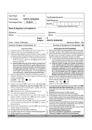
- 1. Test Paper : II Test Subject : EARTH SCIENCES Test Subject Code : K-3214 Test Booklet Serial No. : _______________________ OMR Sheet No. :_________________________________ Roll No. (Figures as per admission card) Name & Signature of Invigilator/s Signature: ____________________________________ Signature: ___________________________________ Name : ____________________________________ Name : ___________________________________ Paper : II Subject : EARTH SCIENCES Time : 1 Hour 15 Minutes Maximum Marks : 100 Number of Pages in this Booklet : 8 Number of Questions in this Booklet : 50 K-3214 1 ±Üâ.£.®æãà./P.T.O. Instructions for the Candidates 1. Write your roll number in the space provided on the top of this page. 2. This paper consists of fifty multiple-choice type of questions. 3. At the commencement of examination, the question booklet will be given to you. In the first 5 minutes, you are requested to open the booklet and compulsorily examine it as below : (i) To have access to the Question Booklet, tear off the paper seal on the edge of this cover page. Do not accept a booklet without sticker-seal and do not accept an open booklet. (ii) Tally the number of pages and number of questions in the booklet with the information printed on the cover page. Faulty booklets due to pages/questions missing or duplicate or not in serial order or any other discrepancy should be got replaced immediately by a correct booklet from the invigilator within the period of 5 minutes. Afterwards, neither the Question Booklet will be replaced nor any extra time will be given. 4. Each item has four alternative responses marked (A), (B), (C) and (D). You have to darken the oval as indicated below on the correct response against each item. Example : A B C D where (C) is the correct response. 5. Your responses to thequestionsare to be indicated in theOMR Sheetkept inside the Paper I Booklet only. If you mark at any place other than in the ovals in the Answer Sheet, it will not be evaluated. 6. Read the instructions given in OMR carefully. 7. Rough Work is to be done in the end of this booklet. 8. If you write your name or put any mark on any part of the OMR Answer Sheet, except for the space allotted for the relevant entries,whichmaydiscloseyouridentity,youwillrenderyourself liable to disqualification. 9. YouhavetoreturnthetestOMRAnswerSheettotheinvigilators at the end of the examination compulsorily and must NOT carry it with you outside the Examination Hall. 10. You can take away question booklet and carbon copy of OMR Answer Sheet soon after the examination. 11. Use only Blue/Black Ball point pen. 12. Use of any calculator or log table etc., is prohibited. 13. There is no negative marks for incorrect answers. A»Ü¦ìWÜÚWæÓÜãaÜ®æWÜÙÜá 1. D±Üâo¨ÜÊæáàÆᤩ¿áÈÉ J¨ÜXÔ¨ÜÓܧÙܨÜÈÉ ¯ÊÜá¾ ÃæãàÇ…®ÜíŸÃÜ®Üá°ŸÃæÀáÄ. 2. D ±Ü£ÅPæ¿áá ŸÖÜá BÁáR Ë«Ü¨Ü IÊÜñÜᤠ±ÜÅÍæ°WÜÙÜ®Üá° JÙÜWæãíw¨æ. 3. ±ÜÄàPæÒ¿á±ÝÅÃÜí»Ü¨ÜÈÉ,±ÜÅÍæ°±ÜâÔ¤Pæ¿á®Üá° ¯ÊÜáWæ¯àvÜÇÝWÜáÊÜâ¨Üá.Êæã¨ÜÆ5¯ËáÐÜWÜÙÜÈÉ ¯àÊÜâ±ÜâÔ¤Pæ¿á®Üá° ñæÃæ¿áÆáÊÜáñÜᤠPæÙÜX®ÜíñæPÜvÝx¿áÊÝX ±ÜÄàQÒÓÜÆáPæãàÃÜÇÝX¨æ. (i) ±ÜÅÍæ°±ÜâÔ¤PæWæ±ÜÅÊæàÍÝÊÜPÝÍܱÜvæ¿áÆá,DÖæã©Pæ±Üâo¨ÜAíb®ÜÊæáàÈÃÜáÊÜ ±æà±ÜÃ…ÔàÆ®Üá° ÖÜÄÀáÄ.ÔrPÜRÃ…ÔàÇ…CÆɨܱÜÅÍæ°±ÜâÔ¤PæÔÌàPÜÄÓܸæàw.ñæÃæ¨Ü ±ÜâÔ¤Pæ¿á®Üá° ÔÌàPÜÄÓܸæàw. (ii) ±ÜâÔ¤Pæ¿áÈɮܱÜÅÍæ°WÜÙÜÓÜíTæÂÊÜáñÜᤠ±ÜâoWÜÙÜÓÜíTæ¿á®Üá° ÊÜááS±Üâo¨ÜÊæáàÇæ ÊÜáá©ÅÔ¨ÜÊÜÞ×£Áãí©WæñÝÙæ®æãàwÄ.±ÜâoWÜÙÜá/±ÜÅÍæ°WÜÙÜáPÝOæ¿Þ¨Ü, A¥ÜÊݩ̱ÜÅ£A¥ÜÊÝA®ÜáPÜÅÊÜáÊÝXÆɨÜA¥ÜÊÝCñÜÃÜ¿ÞÊÜâ¨æàÊÜÂñÝÂÓÜ¨Ü ¨æãàÐܱÜäÄñܱÜâÔ¤Pæ¿á®Üá°PÜãvÜÇæ5 ¯ËáÐܨÜAÊÜ—JÙÜWæ,ÓÜíËàPÜÒPÜÄí¨ÜÓÜÄ CÃÜáÊÜ ±ÜâÔ¤PæWæ Ÿ¨ÜÇÝÀáÔPæãÙÜÛ¸æàPÜá. B ŸÚPÜ ±ÜÅÍæ° ±Ü£ÅPæ¿á®Üá° Ÿ¨ÜÇÝÀáÓÜÇÝWÜáÊÜâ©ÆÉ,¿ÞÊÜâ¨æàÖæaÜác ÓÜÊÜá¿áÊÜ®Üã° PæãvÜÇÝWÜáÊÜâ©ÆÉ. 4. ±ÜÅ£Áãí¨Üá±ÜÅÍæ°WÜã(A),(B),(C) ÊÜáñÜá¤(D)Gí¨ÜáWÜáÃÜá£Ô¨Ü®ÝÆáR±Ü¿Þì¿á EñܤÃÜWÜÚÊæ. ¯àÊÜâ ±ÜÅÍæ°¿á G¨ÜáÃÜá ÓÜÄ¿Þ¨Ü EñܤÃÜ¨Ü ÊæáàÇæ, PæÙÜWæ PÝ~Ô¨Üíñæ AívÝPÜꣿá®Üá° PܱݳXÓܸæàPÜá. E¨ÝÖÜÃÜOæ: A B C D (C) ÓÜÄ¿Þ¨Ü EñܤÃÜÊÝX¨ÝªWÜ. 5. ±ÜÅÍæ° ±Ü£ÅPæ I ÃÜÈÉ PæãqrÃÜáÊÜ OMR EñܤÃÜ ÖÝÙæ¿áÈÉ , ±ÜÅÍæ° ±Ü£ÅPæ I ÊÜáñÜᤠ±ÜÅÍæ° ±Ü£ÅPæ II ÃÜÈÉ CÃÜáÊÜ ±ÜÅÍæ°WÜÚWæ ¯ÊÜá¾ EñܤÃÜWÜÙÜ®Üá° ÓÜãbÓÜñÜPÜR¨Üáª. OMR EñܤÃÜ ÖÝÙæ¿áÈÉ AívÝPÜꣿáÆÉ¨æ ¸æàÃæ ¿ÞÊÜâ¨æà ÓܧÙܨÜÈÉ EñܤÃÜÊÜ®Üá° WÜáÃÜá£Ô¨ÜÃæ, A¨ÜÃÜ ÊÜåèÆÂÊÜÞ±Ü®Ü ÊÜÞvÜÇÝWÜáÊÜâ©ÆÉ. 6. OMR EñܤÃÜ ÖÝÙæ¿áÈÉ Pæãor ÓÜãaÜ®æWÜÙÜ®Üá° hÝWÜÃÜãPÜñæÀáí¨Ü K©Ä. 7. GÇÝÉ PÜÃÜvÜá PæÆÓÜÊÜ®Üá° ±ÜâÔ¤Pæ¿á Pæã®æ¿áÈÉ ÊÜÞvÜñÜPÜR¨Ü᪠. 8. ¯ÊÜá¾ WÜáÃÜáñÜ®Üá° Ÿ×ÃÜíWܱÜwÓÜŸÖÜá¨Ý¨Ü ¯ÊÜá¾ ÖæÓÜÃÜá A¥ÜÊÝ ¿ÞÊÜâ¨æà bÖæ°¿á®Üá°, ÓÜíWÜñÜÊÝ¨Ü ÓܧÙÜ ÖæãÃÜñÜá ±ÜwÔ, OMR EñܤÃÜ ÖÝÙæ¿á ¿ÞÊÜâ¨æà »ÝWܨÜÈÉ ŸÃæ¨ÜÃæ, ¯àÊÜâ A®ÜÖÜìñæWæ ¸Ý«ÜÂÃÝXÃÜᣤàÄ. 9. ±ÜÄàPæÒ¿áá ÊÜááX¨Ü®ÜíñÜÃÜ, PÜvÝx¿áÊÝX OMR EñܤÃÜ ÖÝÙæ¿á®Üá° ÓÜíËàPÜÒPÜÄWæ ¯àÊÜâ ×í£ÃÜáXÓܸæàPÜá ÊÜáñÜᤠ±ÜÄàPÝÒ PæãsÜw¿á ÖæãÃÜWæ OMR ®Üá° ¯Êæã¾í©Wæ Pæãívæã¿á PÜãvܨÜá. 10. ±ÜÄàPæÒ¿á ®ÜíñÜÃÜ, ±ÜÄàPÝÒ ±ÜÅÍæ° ±Ü£ÅPæ¿á®Üá° ÊÜáñÜᤠ®ÜPÜÆá OMR EñܤÃÜ ÖÝÙæ¿á®Üá° ¯Êæã¾í©Wæ ñæWæ¨ÜáPæãívÜá ÖæãàWÜŸÖÜá¨Üá. 11. ¯àÈ/PܱÜâ³ ¸ÝÇ…±ÝÀáíp… ±æ®… ÊÜÞñÜÅÊæà E±ÜÁãàXÔÄ. 12. PÝÂÆáRÇæàoÃ… A¥ÜÊÝ ÇÝW… pæàŸÇ… CñÝ©¿á E±ÜÁãàWÜÊÜ®Üá° ¯Ðæà—ÓÜÇÝX¨æ. 13. ÓÜÄ AÆÉ¨Ü EñܤÃÜWÜÚWæ Má| AíPÜ CÃÜáÊÜâ©ÆÉ .
- 2. Paper II 2 K-3214 *K1314* Total Number of Pages : 8 Note : This paper contains fifty (50) objective type questions. Each question carries two (2) marks. All questions are compulsory. EARTH SCIENCES Paper – II 1. The heat that caused melting in the Earth’s early history was supplied from which of the following events (A) Volcanic activity and radioactivity (B) Solar heating and volcanic activity (C) Large bolide impact and radioactivity (D) Large bolide impact and solar heating 2. The process by which an originally homogeneous earth developed a dense core, mantle and a light crust is called (A) Metamorphism (B) Differentiation (C) Metasomatism (D) Compression 3. Uniformitarianism states (A) "Everything tends toward stable equilibrium” (B) "The present is key to the past" (C) "The present is key to the future" (D) "Order comes out of chaos" 4. The upper mantle has (A) Granitic composition (B) Basic composition (C) Ultramafic composition (D) Felsic composition 5. The asthenosphere exists below the _____________ (A) Crust (B) Lithosphere (C) Sial (D) Lower mantle 6. The approximate density of the earth is (A) 5.5 g/cc (B) 5.8 g/cc (C) 5.1 g/cc (D) 5.2 g/cc 7. Shear zones are normally produced during (A) Brittle deformation (B) Ductile deformation (C) Cooling and contraction of rocks (D) Sagging of rocks
- 3. K-3214 3 Paper II *K1314* Total Number of Pages : 8 8. If the beds are repeating on the surface, they could indicate (A) Columnar jointing in the bed rocks (B) A thrust faulting of beds (C) Intense shear of bed rocks (D) Folding of the beds 9. The upper shell of the earth up to 100 km depth is called (A) Crust (B) Lithosphere (C) Biosphere (D) Asthenosphere 10. The most abundant sedimentary rock found in the Earth’s crust is (A) Shale (B) Sandstone (C) Limestone (D) Conglomerates and Breccias 11. The majority of crustal rocks composed of minerals that belong to the family of (A) Silicates (B) Sulfides (C) Oxides (D) Sulfates 12. Mylonite and gouge normally indicate (A) Intense folding (B) Faulting (C) Jointing (D) Fracturing 13. Of the following, the rock that is most resistant to both chemical and mechanical weathering is (A) Shale (B) Limestone (C) Marble (D) Quartzite 14. Low precipitation and high evaporation rate are characteristic features of the ________________ environment. (A) Lacustrine (B) Fluvial (C) Desert (D) Coastal 15. The sediments that a stream carries along the bottom of the stream channel (A) Bottom load (B) Suspended load (C) Bed load (D) Fine load 16. The vertical distance between the trough point and the summit point of the ripple is called (A) Ripple length (B) Ripple height (C) Summit point (D) Toe point
- 4. *K1314* Total Number of Pages : 8 Paper II 4 K-3214 17. Which of the following process does not occur during diagenesis ? (A) Compaction (B) Cementation (C) Lithification (D) Metamorphism 18. Landform formed due to the action of running water is called (A) Desert (B) Aeolian (C) Fluvial (D) Lacustrine 19. _____________ is the point on earth above the focus of an earthquake. (A) Epicentre (B) Centre of gravity (C) Focal point (D) Stress location 20. The descent of oceanic lithosphere into the mantle is the process of _________ (A) Accretion (B) Subduction (C) Divergence zone (D) Contraction fault 21. Which of the following features is not associated with a convergent plate boundary ? (A) A mid-ocean ridge (B) An earthquake (C) A deep-sea trench zone (D) Volcanic activity 22. How thick is the crust of the Earth ? (A) about 4 miles (B) about 4 km (C) about 40 km (D) about 400 km 23. The Tethys was located between (A) North America and South America (B) North America and Eurasia (C) Eurasia and Africa (D) Antarctica and Australia 24. The most violent volcanoes are referred to as (A) Strombolian type (B) Vesuvian type (C) Hawaiian type (D) Pelean type 25. The layer in which ozone is present is called (A) Troposphere (B) Stratosphere (C) Mesosphere (D) Exosphere 26. The two most predominant green house gases are (A) CO2 and CFC 5 (B) CO 2 and CH 4 (C) CO 2 and CO (D) CO 2 and SO 2
- 5. *K1314* Total Number of Pages : 8 K-3214 5 Paper II 27. A dense mass of water on smoke or dust particles in the lower atmospheric layers constitute (A) Fog (B) Frost (C) Blizzard (D) Mist 28. What fraction of solar radiation arriving at the top of the atmosphere is absorbed at the earth’s surface ? (A) 70% (B) 50% (C) 30% (D) 20% 29. Which one of the following is not due to human influence ? (A) Greenhouse effect (B) Deforestation (C) Contamination of hydrosphere (D) Formation of jet streams 30. Ozone layer depletion is related to (A) Excess carbon dioxide accumulation in the atmosphere (B) Higher solar heat radiation (C) Cooling of the earth (D) Desert storms 31. Excluding the oceans, the largest reservoir of water in the hydrosphere is (A) Ground water (B) Lakes and streams (C) Atmosphere (D) Polar ice 32. Which of the following is not a component of hydrosphere ? (A) Sea ice (B) Tropical rainstorm (C) Soil (D) Hail 33. What do we call an area of land that receives the runoff ? (A) Watershed (B) Estuary (C) Niche (D) Water landscape 34. Chloride and salinity of sea water is expressed in (A) Grams per ton (B) Kilogram per ton (C) Grams per kilograms (D) Miligrams per gram 35. The hydrosphere is the (A) Continuous shell of water (B) Discontinuous shell of water (C) Uniform shell of water (D) Both (A) and (B)
- 6. *K1314* Total Number of Pages : 8 Paper II 6 K-3214 36. Lenses of low permeability rocks within the permeable ones may result in the formation of (A) an artesian system (B) a confined aquifer (C) an aquiclude (D) a perched water table 37. Mesoproterozoic-Neoproterozoic sedimentary basins in the peninsular India are known as (A) Purana (B) Dharwars (C) Indo-Gangetic plains (D) Siwalik 38. The southern junction between the Indian and Eurasian plates in the Himalaya has been designated as (A) Central Indian Tectonic Zone (B) Indus Tsangpo Suture Zone (C) Main Central Thrust (D) Tso Morari Crystalline 39. Layered Igneous rocks could be good sites for the mineralization of (A) Gold (B) Tungsten (C) Chromite (D) Diamonds 40. Which one of the following deposit is conspicuously abundant in India ? (A) Nickel (B) Cobalt (C) Aluminum (D) Platinum 41. The tin bearing mineral in the following is (A) Sphalerite (B) Smithsonite (C) Pyrrhotite (D) Cassiterite 42. Plateau-like land forms are characteristic of (A) Deccan-traps (B) Peninsular gneiss (C) Khondalites (D) Alluvial plains 43. The rapid movement of shallow non-cohesive or loose material down a steep slope following heavy rainfall is called (A) Creep (B) Debris flow (C) Flood (D) Landslide 44. What important role do decomposers play in the ecosystem ? (A) Predation (B) Pollination (C) Nutrient cycling (D) Symbiosis
- 7. *K1314* Total Number of Pages : 8 K-3214 7 Paper II 45. What is the process that reduces nitrate (NO3) to gaseous nitrogen (N2) ? (A) Nitrification (B) Nitrofixation (C) Denitrification (D) Assimilation 46. Soil moisture is found in (A) Zone of saturation (B) Vadose zone (C) Phreatic zone (D) Below the water table 47. Primary ecological succession may be observed in (A) Deep forest (B) New volcanic Islands (C) Coastal areas (D) Delta region 48. The most important Aviation hazard during summer season over North Western India is (A) Dust storm (B) Fog (C) Heavy Rain (D) Icing 49. Nuclear clocks help in understanding (A) Age of a metamorphic event (B) Ages of igneous rocks and metamorphic events (C) The organic world (D) Structure and evolution of the earth 50. Soil forming process chiefly involves (A) Weathering of pre existing igneous rocks (B) Physical and chemical weathering of metamorphic rocks (C) Physical, chemical and biological weathering of rocks (D) Biological and chemical disintegration processes of fractured rocks _____________
- 8. bñÜᤠŸÃÜÖÜPÝRX ÓܧÙÜ Space for Rough Work Paper II 8 K-3214 *K3214* Total Number of Pages : 8