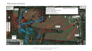
Tattersall Farm
Mapping/Sectors
Sectors
In doing the sector analysis, I began to understand
that it has a significant impact on my farm. Every
inch of land has a sector of influence and must be
factored in the farm design.
Mapping is an important part of our farm and
recording history of what we have done. It will
allow us to see annual changes and see how to
improve yields. (Permaculture, Baine, Pg 9)
When looking at sectors and the zones (Baine, pg
27, Permaculture) zone 1 and 2 are located in some
of the most positively influenced sectors on the
farm. Zone 1 encompasses the greatest amount of
sunlight in both summer and winter exposures.
Our farm is also well designed well for Zone 4
(Baine, pg 29, Permaculture) livestock since it lies
on the edge of zone 5 forest which will provide
blockage from the winter wind and forage food for
pigs.
Water flow
Derrick Heins, Week 2 Mapping and Water Analysis PPT.
StockSch 119. 01/06/18
Principles of Permaculture
8.Integrate, don’t segregate: (Baine, Ch 4, pg
11, Permaculture)
The northeast boundary of the property is a two
lane suburban road. We selected orcharding for
this area of property for easy access to public
“pick your own”. Our orchard is young so we
will integrate grape and barley vining while the
trees mature. This helps to fertilize the soil and
will create an organic sound barrier from
passing traffic. We will also be integrating the a
rotational grazing pattern with fowl, pigs, cattle
and sheep. This will help spread the nutrients
of a post harvest field to the entire farm and
give a more balanced soil collectively. Pigs will
also be used to clear the underbrush and
invasive plants along tree lines.
10. Cultivate Diversity: (Blaine, Ch 4 pg 16,
Permaculture)
We feel that this is very important for our farm. Our
students will have different backgrounds, origins,
skills, and interests. We feel it is our obligation to
incorporate as many species of plant and subspecies
to give our future farmers a thorough knowledge of
all the possibilities when they start their own farms. A
second part of this is also the human factor in the
farms interaction among is staff and students as well
as its community. Our goal with all of the farm
activities is too accommodate as much diversity as
possible with a presence of academics, 4th generation
farmers, primary schoolers, and backyard gardeners.
This diversity will promote a greater contribution to
foodbanks, remove the veteran stigma, and give the
farm greater sustainability by not heavily promoting
just 5 or 6 products.
Derrick Heins, Week 2 Mapping and Water Analysis PPT.
StockSch 119. 01/06/18
WATER ANALYSIS GUIDELINE
Background:
How much precipitation does your area receive annually? Essex County averages 47 inches of rain fall per year and 51 inches
of snow. The average rainfall from April 1 to Dec 1 is 6.5” +/-
Q. Is this precipitation spread out evenly throughout the year? Snowfall is predominate Dec 1 to April 1 with 51”.
Q. What is the name of your local watershed? Merrimack watershed covers an area of south central NH and northeastern MA
and 10 counties between the two states.
Q. Is your soil type clay or sandy or loam? The soil is Woodbury fine sandy loam with bedrock at approximately 60” and
hardpack between 20-24”. Cleared areas are considered prime farmland while forested areas are very stony.
Q. List all of the areas where water enters your site: a. SW of the farm house from the road. B. Originating 100’ from the
NNW corner of the lot along a SW traverse of the northern property line. C. a stream crosses the property halfway across the
NNW property line in a 7acre parcel of trees moving into a seasonal shrub swamp in the middle of the property. D.
Controlled drainage from an abutting development crosses the property in a seasonal shrub swamp about 500’ northwest of
the eastern property line. E. the eastern boundary is Creek Brook which originates from Crystal Lake and Crystal Lake
Reservoir to the north and eventually drains into the Merrimack River.
Q. List all of the areas where water leaves your site:
A. The water exits the site in 3 areas. Source A leaves the site on the southern boundary into a shrub marsh on the
abutting boundary. Source B drains in a southern direction into a shrub marsh that seeps through the forested area in
the middle of the property and exits at the middle of the southern boundary into shrub swamp. Source C and D drain
into a shrub swamp at the southeastern boundary of the property that runs into the abutters and then into Creek
Brook. Section E boarders the eastern property line from north to south.
Q. Where are the high and low points of your site? The property has a varying 3-8% grade from the northern most corner to
the southernmost corner. The elevation is from a high of 45’ to 30’ above sea level from north to south corner.
Derrick Heins, Week 2 Mapping and Water Analysis PPT.
StockSch 119. 01/06/18
Water Analysis (Cont’d)
Note the location of the following for your water map:
Gutters and downspouts: The farmhouse has no gutters or downspouts
Wells: The site uses city water.
Septic Systems: The site uses city sewage.
Hose Hook-ups: There are 3 hose hookups on the house; left, right, and rear. There is one
hose hookup in the community garden. All have good pressure.
Nearby natural water sources.: Creek Brook is protected and inaccessible
Areas of poor drainage: The property has consistent drainage across the cleared acreage and some mild
seasonal water pooling in the forested areas where rocks and roots interrupt the natural erosion.
Q. What are areas of flooding? No noted flood areas.
Q. What are areas that are exposed to potential pollution such as road salt, chemical run-off, etc.? The NNE
boundary is the only area exposed to salt or pollutants due to it being the roadside frontage. A drainage ditch
run the length of the frontage so road run off and salt are minimized. The vegetation along that property line
seems unharmed in the summer months so affect appears to be minimal.
Other observations: The slope of the land varies between 3 and 8 degrees from the north to south. The slope
combined with the hardpack at 24” keeps the water from absorbing immediately and gradually draining across
the cleared fields into the forest. This also prevents water from being absorbed quickly into the sublayers
improving water retention for plant hydration.
Derrick Heins, Week 2 Mapping and Water Analysis PPT.
StockSch 119. 01/06/18
Water Analysis Illustration
Derrick Heins, Week 2 Mapping and Water Analysis PPT.
StockSch 119. 01/06/18

Heins mapping water analysis wk 2

  • 1.
    Tattersall Farm Mapping/Sectors Sectors In doingthe sector analysis, I began to understand that it has a significant impact on my farm. Every inch of land has a sector of influence and must be factored in the farm design. Mapping is an important part of our farm and recording history of what we have done. It will allow us to see annual changes and see how to improve yields. (Permaculture, Baine, Pg 9) When looking at sectors and the zones (Baine, pg 27, Permaculture) zone 1 and 2 are located in some of the most positively influenced sectors on the farm. Zone 1 encompasses the greatest amount of sunlight in both summer and winter exposures. Our farm is also well designed well for Zone 4 (Baine, pg 29, Permaculture) livestock since it lies on the edge of zone 5 forest which will provide blockage from the winter wind and forage food for pigs. Water flow Derrick Heins, Week 2 Mapping and Water Analysis PPT. StockSch 119. 01/06/18
  • 2.
    Principles of Permaculture 8.Integrate,don’t segregate: (Baine, Ch 4, pg 11, Permaculture) The northeast boundary of the property is a two lane suburban road. We selected orcharding for this area of property for easy access to public “pick your own”. Our orchard is young so we will integrate grape and barley vining while the trees mature. This helps to fertilize the soil and will create an organic sound barrier from passing traffic. We will also be integrating the a rotational grazing pattern with fowl, pigs, cattle and sheep. This will help spread the nutrients of a post harvest field to the entire farm and give a more balanced soil collectively. Pigs will also be used to clear the underbrush and invasive plants along tree lines. 10. Cultivate Diversity: (Blaine, Ch 4 pg 16, Permaculture) We feel that this is very important for our farm. Our students will have different backgrounds, origins, skills, and interests. We feel it is our obligation to incorporate as many species of plant and subspecies to give our future farmers a thorough knowledge of all the possibilities when they start their own farms. A second part of this is also the human factor in the farms interaction among is staff and students as well as its community. Our goal with all of the farm activities is too accommodate as much diversity as possible with a presence of academics, 4th generation farmers, primary schoolers, and backyard gardeners. This diversity will promote a greater contribution to foodbanks, remove the veteran stigma, and give the farm greater sustainability by not heavily promoting just 5 or 6 products. Derrick Heins, Week 2 Mapping and Water Analysis PPT. StockSch 119. 01/06/18
  • 3.
    WATER ANALYSIS GUIDELINE Background: Howmuch precipitation does your area receive annually? Essex County averages 47 inches of rain fall per year and 51 inches of snow. The average rainfall from April 1 to Dec 1 is 6.5” +/- Q. Is this precipitation spread out evenly throughout the year? Snowfall is predominate Dec 1 to April 1 with 51”. Q. What is the name of your local watershed? Merrimack watershed covers an area of south central NH and northeastern MA and 10 counties between the two states. Q. Is your soil type clay or sandy or loam? The soil is Woodbury fine sandy loam with bedrock at approximately 60” and hardpack between 20-24”. Cleared areas are considered prime farmland while forested areas are very stony. Q. List all of the areas where water enters your site: a. SW of the farm house from the road. B. Originating 100’ from the NNW corner of the lot along a SW traverse of the northern property line. C. a stream crosses the property halfway across the NNW property line in a 7acre parcel of trees moving into a seasonal shrub swamp in the middle of the property. D. Controlled drainage from an abutting development crosses the property in a seasonal shrub swamp about 500’ northwest of the eastern property line. E. the eastern boundary is Creek Brook which originates from Crystal Lake and Crystal Lake Reservoir to the north and eventually drains into the Merrimack River. Q. List all of the areas where water leaves your site: A. The water exits the site in 3 areas. Source A leaves the site on the southern boundary into a shrub marsh on the abutting boundary. Source B drains in a southern direction into a shrub marsh that seeps through the forested area in the middle of the property and exits at the middle of the southern boundary into shrub swamp. Source C and D drain into a shrub swamp at the southeastern boundary of the property that runs into the abutters and then into Creek Brook. Section E boarders the eastern property line from north to south. Q. Where are the high and low points of your site? The property has a varying 3-8% grade from the northern most corner to the southernmost corner. The elevation is from a high of 45’ to 30’ above sea level from north to south corner. Derrick Heins, Week 2 Mapping and Water Analysis PPT. StockSch 119. 01/06/18
  • 4.
    Water Analysis (Cont’d) Notethe location of the following for your water map: Gutters and downspouts: The farmhouse has no gutters or downspouts Wells: The site uses city water. Septic Systems: The site uses city sewage. Hose Hook-ups: There are 3 hose hookups on the house; left, right, and rear. There is one hose hookup in the community garden. All have good pressure. Nearby natural water sources.: Creek Brook is protected and inaccessible Areas of poor drainage: The property has consistent drainage across the cleared acreage and some mild seasonal water pooling in the forested areas where rocks and roots interrupt the natural erosion. Q. What are areas of flooding? No noted flood areas. Q. What are areas that are exposed to potential pollution such as road salt, chemical run-off, etc.? The NNE boundary is the only area exposed to salt or pollutants due to it being the roadside frontage. A drainage ditch run the length of the frontage so road run off and salt are minimized. The vegetation along that property line seems unharmed in the summer months so affect appears to be minimal. Other observations: The slope of the land varies between 3 and 8 degrees from the north to south. The slope combined with the hardpack at 24” keeps the water from absorbing immediately and gradually draining across the cleared fields into the forest. This also prevents water from being absorbed quickly into the sublayers improving water retention for plant hydration. Derrick Heins, Week 2 Mapping and Water Analysis PPT. StockSch 119. 01/06/18
  • 5.
    Water Analysis Illustration DerrickHeins, Week 2 Mapping and Water Analysis PPT. StockSch 119. 01/06/18