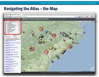
Creating Interactive, Collaborative
Online Maps for Community Planning
     using the Google Maps API
           Cary Chadwick, Geospatial Training Program Coordinator
University of Connecticut Center for Land Use Education & Research (CLEAR)

                           Ken Livingston, AICP
                Vice President, Fitzgerald & Halliday, Inc.

                 David Dickson, NEMO Network Coordinator
University of Connecticut Center for Land Use Education & Research (CLEAR)
Center for Land Use Education and Research at the University of Connecticut


Google Maps Brings Mapping to the Masses


   National LID Atlas   CT Bike Map                                       MDC Road Closures


    Did you see
     that map?


                                                             I think it is a
                                                             Google Map!
Center for Land Use Education and Research at the University of Connecticut


   Why Google?


     Google, Who?
      Google Maps is ubiquitous
      Google Maps is intuitive
      Google Maps is flexible
      Google Maps is resourceful
      Google Maps is pretty cool.


                                                                                                                                                             Micky Hulse

© University of Connecticut. The University of Connecticut supports all state and federal laws that promote equal opportunity and prohibit discrimination.
Center for Land Use Education and Research at the University of Connecticut


   What is a Mashup Anyway?
         Mashups combine separate, stand-alone technologies into a novel
         application, often functioning through an application programming
           interface (API) which facilitates communication between the
               technologies without modification of the source code.
                                                                                                                                                                         Your Data


                                                                                                                                             DOMINANT SPECIES
                                                                                                                                                  Spartina patens
                                                                                                                                                  Phragmites australis
                                                                                                                                                  Typha sp.

        Google Maps                                                                                                                               Sedges
                                                                                                                                                  Flotsam


© University of Connecticut. The University of Connecticut supports all stateUnique Application
                                                                             and federal laws that promote equal opportunity and prohibit discrimination.
Center for Land Use Education and Research at the University of Connecticut


   Many Ways to Make a Map


          Anyone can do it!                                                                                                Trending Toward the Techies

                                                                       Range of Techniques
                   Google Maps My Maps                                        Google Earth                                  Programming Mapping APIs,
                     Google Map Maker                                             KML                                       HTML, JavaScript, Database
                    Google Fusion Tables                                    API Development                                         Integration
                        MapBuilder                                           Map Services
                         BatchGeo                                               Mapplets
                                                                                GeoRSS
                           Many More!

© University of Connecticut. The University of Connecticut supports all state and federal laws that promote equal opportunity and prohibit discrimination.
Center for Land Use Education and Research at the University of Connecticut


Working with the Google Maps API
What You Need to Know:
API = Application Programming Interface
 Provides access to an application (Google Maps)
 Flexible and customizable
 Mobile and browser friendly
 Requires some programming knowledge to unlock full potential
 Lots of online HELP!
 Many ways to make a map with the Google API
Center for Land Use Education and Research at the University of Connecticut


Let’s See it in Action!
National LID Atlas                                                         CT Bike Map


                       MDC Road Closures
Center for Land Use Education and Research at the University of Connecticut


                            The National LID
                                 Atlas

                         A Collaborative Local Resource


© University of Connecticut. The University of Connecticut supports all state and federal laws that promote equal opportunity and prohibit discrimination.
Center for Land Use Education and Research at the University of Connecticut


  The LID Atlas in 3 Parts

   1. Navigating the Atlas


   2. Adding to the Atlas


   3. Embedding the Atlas


© University of Connecticut. The University of Connecticut supports all state and federal laws that promote equal opportunity and prohibit discrimination.
Center for Land Use Education and Research at the University of Connecticut


    UConn Center for Land Use Education & Research
   CLEAR’s Mission:
   To provide information, education and assistance to
   land use decision makers in support of balancing
   growth and natural resource protection.


   CLEAR Programs:
   •     Connecticut NEMO
   •     National NEMO Network
   •     Geospatial Training Program
   •     Land Use Academy
   •     Community & Natural Resource Planning Program (CNP)
   •     Extension Forestry Program
   •     Lab for Earth Resource Information Systems


                                                           clear.uconn.edu
          CLEAR is a collaboration of the Dept. of Extension, the Dept. of Natural Resources and
                         the Environment, and the Connecticut Sea Grant Program
© University of Connecticut. The University of Connecticut supports all state and federal laws that promote equal opportunity and prohibit discrimination.
Center for Land Use Education and Research at the University of Connecticut


The FREE! Technology Behind The Magic


                                           1. Google Maps API

                                           2. My SQL Database

                                           3. A Smart Programmer
                                           (or two or three)

                                           4. Google Forms
Center for Land Use Education and Research at the University of Connecticut


Navigating the Atlas – the Map


       http://clear.uconn.edu/tools/lidmap

             www.tinyurl.com/lidatlas

                Google: LID Atlas
Center for Land Use Education and Research at the University of Connecticut


Navigating the Atlas – Finding Projects
Center for Land Use Education and Research at the University of Connecticut


Navigating the Atlas – Finding Projects
Center for Land Use Education and Research at the University of Connecticut


Navigating the Atlas – Finding Projects
Center for Land Use Education and Research at the University of Connecticut


Adding to the Atlas – 3 Ways

1. On the site

2. Bulk upload

3. Become a user          david.dickson@uconn.e
                                     du
Center for Land Use Education and Research at the University of Connecticut


Usage Statistics

             National LID Atlas Monthly Usage
                      (unique visitors)
      2000

      1800

      1600

      1400

      1200

      1000
                                                                                   975
      800

      600

      400

      200

        0


                   National Map          Embed Maps
Center for Land Use Education and Research at the University of Connecticut


Steal our Atlas, please!
         www.youtube.com/nemohub
Center for Land Use Education and Research at the University of Connecticut


Thanks! Now start adding your sites.

                   David Dickson
               UConn CLEAR/Extension

       Email: david.dickson@uconn.edu
       Web: http://nemonet.uconn.edu
       YouTube: http://www.youtube.com/nemohub
Connecticut Bicycle Map
• Developed as part of Update 
  to Statewide Bicycle and 
  Pedestrian Plan
• CTDOT project
• Steering Committee


                                                Page 22
                                      SNEAPA Conference
                                         Google Maps API
                                 Friday, October 21, 2011
In the 
Beginning…
•   Hard copy
•   Reprinted???
•   Updated???
•   Easy to use???


                                    Page 23
                          SNEAPA Conference
                             Google Maps API
                     Friday, October 21, 2011
CT Bike Map Purpose
• On‐line version of 
  paper map
• Include additional 
  geographic information
• Cost effective
• Easily hosted
• Easily updated
• Cutting edge
                                          Page 24
                                SNEAPA Conference
                                   Google Maps API
                           Friday, October 21, 2011
The Process
• Develop line coverage in ArcGIS
   – Suitability of roads based on shoulder width 
     and traffic volumes
   – Obtain multi‐use trails and bicycle paths from variety of sources
       • Municipalities
       • Regional agencies
       • Community organizations
• Export KML files
• Coding/Web design
• Create awareness of on‐line map


                                                                                   Page 25
                                                                         SNEAPA Conference
                                                                            Google Maps API
                                                                    Friday, October 21, 2011
Behind the Curtain


                                    Page 26
                          SNEAPA Conference
                             Google Maps API
                     Friday, October 21, 2011
http://www.ctbikemap.org


                                          Page 27
                                SNEAPA Conference
                                   Google Maps API
                           Friday, October 21, 2011
Using the Bicycle Map


             Search by address


                                                Page 28
                                      SNEAPA Conference
                                         Google Maps API
                                 Friday, October 21, 2011
Using the Bicycle Map


             Search by address


                                                Page 29
                                      SNEAPA Conference
                                         Google Maps API
                                 Friday, October 21, 2011
Using the Bicycle Map


           Search for statewide routes


                                                        Page 30
                                              SNEAPA Conference
                                                 Google Maps API
                                         Friday, October 21, 2011
Using the Bicycle Map


         Search by road suitability for bicycling


                                                                   Page 31
                                                         SNEAPA Conference
                                                            Google Maps API
                                                    Friday, October 21, 2011
Using the Bicycle Map


            Search for multi-use paths


                                                        Page 32
                                              SNEAPA Conference
                                                 Google Maps API
                                         Friday, October 21, 2011
What We Have Heard


                                    Page 33
                          SNEAPA Conference
                             Google Maps API
                     Friday, October 21, 2011
Give Me the Numbers!!!


                                        Page 34
                              SNEAPA Conference
                                 Google Maps API
                         Friday, October 21, 2011
Future Improvements
•   Receive user comments/feedback
•   Bicycling directions
•   Integration of Google StreetView
•   Integrate with other social media such
    – Twitter
    – Facebook


                                                            Page 35
                                                  SNEAPA Conference
                                                     Google Maps API
                                             Friday, October 21, 2011
MDC Traffic Information


                                         Page 36
                               SNEAPA Conference
                                  Google Maps API
                          Friday, October 21, 2011
The Clean Water Project
• Metropolitan District Commission 
  (MDC)
   – 8 communities
   – Regional water and sewer services
• Federal consent decree
• Reduce combine sewer overflows
• Eliminate sanitary sewer 
  overflows
• $1 billion in projects
• Complete by 2020


                                                        Page 37
                                              SNEAPA Conference
                                                 Google Maps API
                                         Friday, October 21, 2011
MDC Traffic Information
• Regional work program
• Dig up streets throughout region
  – Roads closed
  – Lanes closed
  – Diversions
• Emergency repairs
• Real time updates
• Businesses/commuters/residents/emergency
  responders
• Coordination with municipalities/utilities
                                                        Page 38
                                              SNEAPA Conference
                                                 Google Maps API
                                         Friday, October 21, 2011
The Process Looks Simple


                                          Page 39
                                SNEAPA Conference
                                   Google Maps API
                           Friday, October 21, 2011
Behind the Curtain


                                    Page 40
                          SNEAPA Conference
                             Google Maps API
                     Friday, October 21, 2011
Day to Day Upkeep
                         Determine 
                        Daily Activity

        Upload to                         Geocode 
         Cloud                            Activity


                                         Coordinate 
       Export to CSV 
                                            with 
           file
                                         Contractors
                        Input Project 
                         Information

                                                                      Page 41
                                                            SNEAPA Conference
                                                               Google Maps API
                                                       Friday, October 21, 2011
http://www.mdc‐roadclosures.com


                                           Page 42
                                 SNEAPA Conference
                                    Google Maps API
                            Friday, October 21, 2011
Select Dates to Display Traffic Alerts


                                                  Page 43
                                        SNEAPA Conference
                                           Google Maps API
                                   Friday, October 21, 2011
Search by Address


                                   Page 44
                         SNEAPA Conference
                            Google Maps API
                    Friday, October 21, 2011
Information Windows


                                     Page 45
                           SNEAPA Conference
                              Google Maps API
                      Friday, October 21, 2011
Getting the Word Out


                                      Page 46
                            SNEAPA Conference
                               Google Maps API
                       Friday, October 21, 2011
Give Me the Numbers!!!


                                        Page 47
                              SNEAPA Conference
                                 Google Maps API
                         Friday, October 21, 2011
Lessons Learned
• Technology and 
  options constantly 
  evolving
• Public appreciates and 
  expects innovation
• Need to work with GIS 
  and web designers 
  together
• Options are infinite
                                           Page 48
                                 SNEAPA Conference
                                    Google Maps API
                            Friday, October 21, 2011
Another Great Example


               http://youmovemassachusetts.org/map.php


                                                         Page 49
                                               SNEAPA Conference
                                                  Google Maps API
                                          Friday, October 21, 2011
Contact Information
Ken Livingston, AICP
Vice President
Fitzgerald & Halliday, Inc.
klivingston@fhiplan.com
860.247.7200
www.fhiplan.com


                                             Page 50
                                   SNEAPA Conference
                                      Google Maps API
                              Friday, October 21, 2011

Creating Interactive, Collaborative Online Maps for Community Planning using the Google Maps API

  • 1.
    Creating Interactive, Collaborative OnlineMaps for Community Planning using the Google Maps API Cary Chadwick, Geospatial Training Program Coordinator University of Connecticut Center for Land Use Education & Research (CLEAR) Ken Livingston, AICP Vice President, Fitzgerald & Halliday, Inc. David Dickson, NEMO Network Coordinator University of Connecticut Center for Land Use Education & Research (CLEAR)
  • 2.
    Center for LandUse Education and Research at the University of Connecticut Google Maps Brings Mapping to the Masses National LID Atlas CT Bike Map MDC Road Closures Did you see that map? I think it is a Google Map!
  • 3.
    Center for LandUse Education and Research at the University of Connecticut Why Google? Google, Who?  Google Maps is ubiquitous  Google Maps is intuitive  Google Maps is flexible  Google Maps is resourceful  Google Maps is pretty cool. Micky Hulse © University of Connecticut. The University of Connecticut supports all state and federal laws that promote equal opportunity and prohibit discrimination.
  • 4.
    Center for LandUse Education and Research at the University of Connecticut What is a Mashup Anyway? Mashups combine separate, stand-alone technologies into a novel application, often functioning through an application programming interface (API) which facilitates communication between the technologies without modification of the source code. Your Data DOMINANT SPECIES Spartina patens Phragmites australis Typha sp. Google Maps Sedges Flotsam © University of Connecticut. The University of Connecticut supports all stateUnique Application and federal laws that promote equal opportunity and prohibit discrimination.
  • 5.
    Center for LandUse Education and Research at the University of Connecticut Many Ways to Make a Map Anyone can do it! Trending Toward the Techies Range of Techniques Google Maps My Maps Google Earth Programming Mapping APIs, Google Map Maker KML HTML, JavaScript, Database Google Fusion Tables API Development Integration MapBuilder Map Services BatchGeo Mapplets GeoRSS Many More! © University of Connecticut. The University of Connecticut supports all state and federal laws that promote equal opportunity and prohibit discrimination.
  • 6.
    Center for LandUse Education and Research at the University of Connecticut Many Ways to Make a Map Anyone can do it! Trending Toward the Techies Range of Techniques Google Maps My Maps Google Earth Programming Mapping APIs, Google Map Maker KML HTML, JavaScript, Database Google Fusion Tables API Development Integration MapBuilder Map Services BatchGeo Mapplets GeoRSS Many More! © University of Connecticut. The University of Connecticut supports all state and federal laws that promote equal opportunity and prohibit discrimination.
  • 7.
    Center for LandUse Education and Research at the University of Connecticut Working with the Google Maps API What You Need to Know: API = Application Programming Interface  Provides access to an application (Google Maps)  Flexible and customizable  Mobile and browser friendly  Requires some programming knowledge to unlock full potential  Lots of online HELP!  Many ways to make a map with the Google API
  • 8.
    Center for LandUse Education and Research at the University of Connecticut Let’s See it in Action! National LID Atlas CT Bike Map MDC Road Closures
  • 9.
    Center for LandUse Education and Research at the University of Connecticut The National LID Atlas A Collaborative Local Resource © University of Connecticut. The University of Connecticut supports all state and federal laws that promote equal opportunity and prohibit discrimination.
  • 10.
    Center for LandUse Education and Research at the University of Connecticut The LID Atlas in 3 Parts 1. Navigating the Atlas 2. Adding to the Atlas 3. Embedding the Atlas © University of Connecticut. The University of Connecticut supports all state and federal laws that promote equal opportunity and prohibit discrimination.
  • 11.
    Center for LandUse Education and Research at the University of Connecticut UConn Center for Land Use Education & Research CLEAR’s Mission: To provide information, education and assistance to land use decision makers in support of balancing growth and natural resource protection. CLEAR Programs: • Connecticut NEMO • National NEMO Network • Geospatial Training Program • Land Use Academy • Community & Natural Resource Planning Program (CNP) • Extension Forestry Program • Lab for Earth Resource Information Systems clear.uconn.edu CLEAR is a collaboration of the Dept. of Extension, the Dept. of Natural Resources and the Environment, and the Connecticut Sea Grant Program © University of Connecticut. The University of Connecticut supports all state and federal laws that promote equal opportunity and prohibit discrimination.
  • 12.
    Center for LandUse Education and Research at the University of Connecticut
  • 13.
    Center for LandUse Education and Research at the University of Connecticut The FREE! Technology Behind The Magic 1. Google Maps API 2. My SQL Database 3. A Smart Programmer (or two or three) 4. Google Forms
  • 14.
    Center for LandUse Education and Research at the University of Connecticut Navigating the Atlas – the Map http://clear.uconn.edu/tools/lidmap www.tinyurl.com/lidatlas Google: LID Atlas
  • 15.
    Center for LandUse Education and Research at the University of Connecticut Navigating the Atlas – Finding Projects
  • 16.
    Center for LandUse Education and Research at the University of Connecticut Navigating the Atlas – Finding Projects
  • 17.
    Center for LandUse Education and Research at the University of Connecticut Navigating the Atlas – Finding Projects
  • 18.
    Center for LandUse Education and Research at the University of Connecticut Adding to the Atlas – 3 Ways 1. On the site 2. Bulk upload 3. Become a user david.dickson@uconn.e du
  • 19.
    Center for LandUse Education and Research at the University of Connecticut Usage Statistics National LID Atlas Monthly Usage (unique visitors) 2000 1800 1600 1400 1200 1000 975 800 600 400 200 0 National Map Embed Maps
  • 20.
    Center for LandUse Education and Research at the University of Connecticut Steal our Atlas, please! www.youtube.com/nemohub
  • 21.
    Center for LandUse Education and Research at the University of Connecticut Thanks! Now start adding your sites. David Dickson UConn CLEAR/Extension Email: david.dickson@uconn.edu Web: http://nemonet.uconn.edu YouTube: http://www.youtube.com/nemohub
  • 22.
    Connecticut Bicycle Map • Developed as part of Update  to Statewide Bicycle and  Pedestrian Plan • CTDOT project • Steering Committee Page 22 SNEAPA Conference Google Maps API Friday, October 21, 2011
  • 23.
    In the  Beginning… • Hard copy • Reprinted??? • Updated??? • Easy to use??? Page 23 SNEAPA Conference Google Maps API Friday, October 21, 2011
  • 24.
    CT Bike Map Purpose • On‐line version of  paper map • Include additional  geographic information • Cost effective • Easily hosted • Easily updated • Cutting edge Page 24 SNEAPA Conference Google Maps API Friday, October 21, 2011
  • 25.
    The Process • Develop line coverage in ArcGIS – Suitability of roads based on shoulder width  and traffic volumes – Obtain multi‐use trails and bicycle paths from variety of sources • Municipalities • Regional agencies • Community organizations • Export KML files • Coding/Web design • Create awareness of on‐line map Page 25 SNEAPA Conference Google Maps API Friday, October 21, 2011
  • 26.
    Behind the Curtain Page 26 SNEAPA Conference Google Maps API Friday, October 21, 2011
  • 27.
    http://www.ctbikemap.org Page 27 SNEAPA Conference Google Maps API Friday, October 21, 2011
  • 28.
    Using the Bicycle Map Search by address Page 28 SNEAPA Conference Google Maps API Friday, October 21, 2011
  • 29.
    Using the Bicycle Map Search by address Page 29 SNEAPA Conference Google Maps API Friday, October 21, 2011
  • 30.
    Using the Bicycle Map Search for statewide routes Page 30 SNEAPA Conference Google Maps API Friday, October 21, 2011
  • 31.
    Using the Bicycle Map Search by road suitability for bicycling Page 31 SNEAPA Conference Google Maps API Friday, October 21, 2011
  • 32.
    Using the Bicycle Map Search for multi-use paths Page 32 SNEAPA Conference Google Maps API Friday, October 21, 2011
  • 33.
    What We Have Heard Page 33 SNEAPA Conference Google Maps API Friday, October 21, 2011
  • 34.
    Give Me the Numbers!!! Page 34 SNEAPA Conference Google Maps API Friday, October 21, 2011
  • 35.
    Future Improvements • Receive user comments/feedback • Bicycling directions • Integration of Google StreetView • Integrate with other social media such – Twitter – Facebook Page 35 SNEAPA Conference Google Maps API Friday, October 21, 2011
  • 36.
    MDC Traffic Information Page 36 SNEAPA Conference Google Maps API Friday, October 21, 2011
  • 37.
    The Clean Water Project • Metropolitan District Commission  (MDC) – 8 communities – Regional water and sewer services • Federal consent decree • Reduce combine sewer overflows • Eliminate sanitary sewer  overflows • $1 billion in projects • Complete by 2020 Page 37 SNEAPA Conference Google Maps API Friday, October 21, 2011
  • 38.
    MDC Traffic Information • Regional work program • Dig up streets throughoutregion – Roads closed – Lanes closed – Diversions • Emergency repairs • Real time updates • Businesses/commuters/residents/emergency responders • Coordination with municipalities/utilities Page 38 SNEAPA Conference Google Maps API Friday, October 21, 2011
  • 39.
    The Process Looks Simple Page 39 SNEAPA Conference Google Maps API Friday, October 21, 2011
  • 40.
    Behind the Curtain Page 40 SNEAPA Conference Google Maps API Friday, October 21, 2011
  • 41.
    Day to Day Upkeep Determine  Daily Activity Upload to  Geocode  Cloud Activity Coordinate  Export to CSV  with  file Contractors Input Project  Information Page 41 SNEAPA Conference Google Maps API Friday, October 21, 2011
  • 42.
    http://www.mdc‐roadclosures.com Page 42 SNEAPA Conference Google Maps API Friday, October 21, 2011
  • 43.
    Select Dates to Display Traffic Alerts Page 43 SNEAPA Conference Google Maps API Friday, October 21, 2011
  • 44.
    Search by Address Page 44 SNEAPA Conference Google Maps API Friday, October 21, 2011
  • 45.
    Information Windows Page 45 SNEAPA Conference Google Maps API Friday, October 21, 2011
  • 46.
    Getting the Word Out Page 46 SNEAPA Conference Google Maps API Friday, October 21, 2011
  • 47.
    Give Me the Numbers!!! Page 47 SNEAPA Conference Google Maps API Friday, October 21, 2011
  • 48.
    Lessons Learned • Technology and  options constantly  evolving • Public appreciates and  expects innovation • Need to work with GIS  and web designers  together • Options are infinite Page 48 SNEAPA Conference Google Maps API Friday, October 21, 2011
  • 49.
    Another Great Example http://youmovemassachusetts.org/map.php Page 49 SNEAPA Conference Google Maps API Friday, October 21, 2011
  • 50.