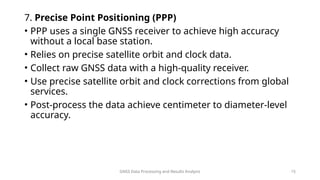
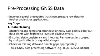
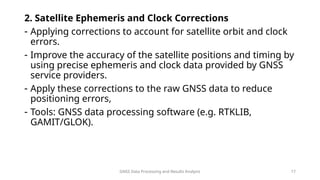
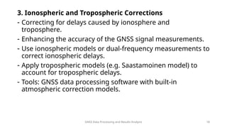
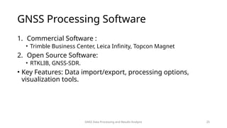
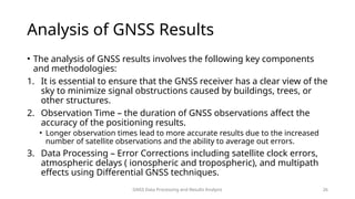
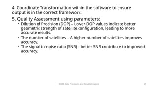
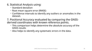
STATIC GNSS DATA
PROCESSING AND
ANALYSIS
Presented by Leonard Ouma
Static GNSS Data Processing and Results Analysis 1
GNSS Data Processing and Results Analysis 2
Introduction to
GNSS
• GNSS refers to satellite system that provide
global geo-spatial positioning.
• Receivers on ground use signals from
satellites to compute their positions
through trilateration.
• Includes satellite system such as:
• GPS(Global Positioning System) – USA
• GLONASS – Russia
• Galileo – EU
• BeiDou - Gina
Components of GNSS
GNSS
Data
Processing
and
Results
Analysis
1. Space Segment: Satellites orbiting the Earth. Need a minimum of 4
satellites for a fix solution.
- Send location signals which may be received by receivers on earth.
2. Control Segment: Ground stations that monitor and manage the satellite
system.
-Ephemeris for controlling or calibrating error from segments.
-Example of controlling errors is by using a base station on earth on a
known fixed position.
-Replace base station with CORS.
3. User Segment: GNSS receivers used by end-users
3
GNSS Data Processing and Results Analysis 4
GNSS satellites determine their positional information using a
combination of precise timing, atomic clocks, regular updates from
ground control stations and advanced orbital mechanics.
They are equipped with on-board atomic clocks to provide the
accurate timing necessary for determining their position.
Ephemeris Data: the satellite broadcasts ephemeris data, which
includes information about its position in orbit at any given time, this
data is calculated using the satellite’s orbital parameters and is
regularly updated.
Ground Control Stations: Ground control stations continuously track
the satellites and update their orbital parameters. They send these
updates to the satellites, ensuring that the ephemeris data remains
accurate.
GNSS Data Types
• Pseudorange Data- represents the distance between a GNSS satellite and a
receiver
- Calculated based on the time it takes for the satellite signal to reach the
receiver
- Includes corrections for satellite clock errors.
• Carrier Phase Data – Measures the phase of the carrier wave of the GNSS
signal.
- Provides higher accuracy compared to pseudorange measurements.
- Important for precise applications such as geodesy and surveying.
GNSS Data Processing and Results Analysis 5
• Doppler Data – Measures the change in frequency of the GNSS signal due to the relative motion of
the satellite and the receiver.
- Used to calculate the velocity of the receiver.
• Satellite Ephemeris Data – Contains information about the satellite's orbit.
- Used to determine the satellite’s position at any given time.
- Includes both broadcast and precise ephemeris data.
• Satellite Clock Data – Information about the satellite’s clock bias and drift.
- Necessary for correcting timing errors in pseudorange measurements.
• Ionospheric Data – provides information on the ionospheric conditions affecting the GNSS signals.
- Used to correct ionospheric delays in signal propagation.
GNSS Data Processing and Results Analysis 6
• Tropospheric Data – contains information on the tropospheric conditions
impacting GNSS signals.
- Used to correct tropospheric delays in signal propagation.
• Multipath Data – Information about signal reflections causing multipath
errors.
- Used to mitigate multipath effects on GNSS measurements.
• Raw GNSS Data – includes all measurements and observations collected by
the GNSS receiver.
- Used for post-processing to improve accuracy and reliability.
GNSS Data Processing and Results Analysis 7
Differential Corrections Data
- Data provided by reference stations to correct GNSS errors.
- Used in Differential GNSS (DGNSS) to enhance positional accuracy.
• RTCM ( Radio Technical Commission for Maritime Services) Data:
- Standardized format for differential GNSS corrections.
- Widely used for real-time GNSS applications.
• RINEX (Receiver Independent Exchange Format) Data – Standardized format for storing
GNSS observation data.
- Facilitates data exchange and post-processing among different GNSS receivers.
- Understanding and utilizing these GNSS data types is essential for various applications.
GNSS Data Processing and Results Analysis 8
GNSS Data Processing and Results Analysis 9
GNSS Data Collections
• Equipment – GNSS Receivers, Antennas
1. Static GNSS Surveying
- Static GNSS surveying involves collecting data at a stationary point over
a prolonged period.
- Suitable for applications requiring high precision, such as geodetic
surveys and establishing control points.
- Procedure involves setting up a GNSS receiver on affixed point and
recording data continuously for at least 30 minutes to several hours.
- Post-process the collected data using software to achieve high- accuracy
results.
- Applications in Geodetic Control Networks, Baseline determination for
deformation monitoring and cadastral surveying.
GNSS Data Processing and Results Analysis 10
2. Kinematic GNSS Surveying
- Kinematic GNSS surveying involves collecting data while the
receiver is in motion.
- Provides real-time position updates and is suitable for dynamic
applications.
- Procedure involves setting up a base station at a known location.
- Equip a rover that moves along the survey path.
- Use real-time kinematic (RTK) techniques to correct the rover’s
position in real-time, achieving centimeter-level accuracy.
- Applications in road and railway construction, precision agriculture
and hydrographic surveying.
GNSS Data Processing and Results Analysis 11
3. Differential GNSS (DGNSS)
- DGNSS enhances the accuracy of GNSS positioning by using
reference stations.
- Provides corrections to reduce errors caused by atmospheric
condition, satellite orbit errors, and other factors.
- Procedure involves establishing a base station at a known location.
- The base station calculates and broadcasts correction signals.
- Rover receivers use these corrections to improve their positional
accuracy.
GNSS Data Processing and Results Analysis 12
4. Real-Time Kinematic (RTK) GNSS
- RTK GNSS is a differential GNSS method that provides real-time
corrections.
- Achieves centimeter-level accuracy by correcting signal errors in
real-time.
- Procedure set up a base station at a known location.
- Use a rover that receives corrections from the base station via
radio, cellular networks or the internet.
- The rover applies these corrections to its position calculations.
GNSS Data Processing and Results Analysis 13
5. Network RTK (NRTK)
- Network RTK uses a network of base stations to provide
corrections over a large area.
- Increases the coverage area and reliability of RTK solutions.
- Procedure involves a network of GNSS reference stations
continuously collecting data.
- Corrections are calculated and transmitted to users via the internet
or other communication methods.
- The rover receivers apply these corrections in real-time to achieve
high accuracy.
GNSS Data Processing and Results Analysis 14
6. Post-Processed Kinematic (PPK) GNSS
- PPK GNSS involves collecting data in kinematic mode and post-
processing it later.
- Provides high accuracy without the need for real-time corrections.
- Collect raw GNSS data with both base and rover receivers during
the survey.
- After the survey, download the data and process it using
specialized software to correct and improve accuracy.
GNSS Data Processing and Results Analysis 15
7. Precise Point Positioning (PPP)
• PPP uses a single GNSS receiver to achieve high accuracy
without a local base station.
• Relies on precise satellite orbit and clock data.
• Collect raw GNSS data with a high-quality receiver.
• Use precise satellite orbit and clock corrections from global
services.
• Post-process the data achieve centimeter to diameter-level
accuracy.
GNSS Data Processing and Results Analysis 16
Pre-Processing GNSS Data
- Involves several procedures that clean, prepare raw data for
further analysis or applications.
Key Steps
1. Data Cleaning
- Identifying and removing erroneous or noisy data points. Filter out
data points with high noise levels or obvious errors.
- Ensuring data consistency and integrity. Remove outliers caused
by multipath effects or signal blockages.
- Check for missing data and handle gaps appropriately.
- Tools: GNSS data processing software (e.g. TEQC, GPS Solutions).
GNSS Data Processing and Results Analysis 17
2. Satellite Ephemeris and Clock Corrections
- Applying corrections to account for satellite orbit and clock
errors.
- Improve the accuracy of the satellite positions and timing by
using precise ephemeris and clock data provided by GNSS
service providers.
- Apply these corrections to the raw GNSS data to reduce
positioning errors,
- Tools: GNSS data processing software (e.g. RTKLIB,
GAMIT/GLOK).
GNSS Data Processing and Results Analysis 18
3. Ionospheric and Tropospheric Corrections
- Correcting for delays caused by ionosphere and
troposphere.
- Enhancing the accuracy of the GNSS signal measurements.
- Use ionospheric models or dual-frequency measurements to
correct ionospheric delays.
- Apply tropospheric models (e.g. Saastamoinen model) to
account for tropospheric delays.
- Tools: GNSS data processing software with built-in
atmospheric correction models.
GNSS Data Processing and Results Analysis 19
4. Multipath Mitigation
- Ensuring the integrity of the GNSS measurements
- Identify and remove or correct multipath-affected data
points to reduce errors caused by signal reflections from
nearby surfaces.
- Use antenna placement strategies and advanced receiver
technologies to minimize multipath effects.
- Tools: Multipath mitigation algorithms and filter in GNSS
processing software.
GNSS Data Processing and Results Analysis 20
5. Data Transformation and Coordinate Conversion
- Converting GNSS data to the required coordinate system or
format.
- Ensuring compatibility with other spatial data and
applications.
- Transform GNSS coordinates from WGS84 to local or project-
specific coordinate systems.
- Convert data formats to standard formats like RINEX for
further processing.
- Tools: Coordinate transformation tools, GNSS data format
converters (e.g., TEQC).
GNSS Data Processing and Results Analysis 21
6. Differential Corrections
- Applying corrections from reference stations to improve
accuracy.
- Common in Differential (DGNSS) and Real-Time Kinematic
(RTK) applications.
- Obtain correction data from a base station or correction
service.
- Apply these corrections to the rover data to enhance
positional accuracy.
- Tools: RTK software (e.g., RTKLIB), and use of Differential
correction services (e.g., SBAS, CORS).
GNSS Data Processing and Results Analysis 22
7. Cycle Slip Detection and Correction
- Identifying and correcting cycle slips in carrier phase
measurements.
- Ensuring continuous and accurate phase data.
- Detect cycle slips using algorithms that analyze phase
continuity.
- Correct detected cycle slips y adjusting the phase data
accordingly.
- Tools: GNSS data processing software with cycle slip
detection capabilities.
GNSS Data Processing and Results Analysis 23
8. Data Synchronization
- Ensuring temporal alignment of data from multiple
receivers.
- Crucial for applications involving multiple rover or base
stations.
- Align timestamps of data from different receivers.
- Interpolate or resample data to ensure consistent temporal
resolution.
- Tools: GNSS data synchronization tools and software.
• Utilizing appropriate software tools and methodologies for
pre-processing enhances the overall quality and usability of
GNSS data.
GNSS Data
Processing
Techniques
1. Single Point Positioning (SPP): Basic
processing technique using only
code measurements.
2. Differential GNSS (DGNSS): Enhances
accuracy by using a base station with
known coordinate.
3. Real-Time Kinematic (RTK): Provides
centimeter-level accuracy by using
carrier phase measurements in real-
time.
4. Post-Processed Kinematic (PPK):
Similar to RTK but processed after
data collection.
5. Precise Point Positioning (PPP): High
accuracy positioning using precise
satellite orbit and clock data.
GNSS Data Processing and Results Analysis
24
GNSS Data Processing and Results Analysis 25
GNSS Processing Software
1. Commercial Software :
• Trimble Business Center, Leica Infinity, Topcon Magnet
2. Open Source Software:
• RTKLIB, GNSS-SDR.
• Key Features: Data import/export, processing options,
visualization tools.
GNSS Data Processing and Results Analysis 26
Analysis of GNSS Results
• The analysis of GNSS results involves the following key components
and methodologies:
1. It is essential to ensure that the GNSS receiver has a clear view of the
sky to minimize signal obstructions caused by buildings, trees, or
other structures.
2. Observation Time – the duration of GNSS observations affect the
accuracy of the positioning results.
• Longer observation times lead to more accurate results due to the increased
number of satellite observations and the ability to average out errors.
3. Data Processing – Error Corrections including satellite clock errors,
atmospheric delays ( ionospheric and tropospheric), and multipath
effects using Differential GNSS techniques.
GNSS Data Processing and Results Analysis 27
4. Coordinate Transformation within the software to ensure
output is in the correct framework.
5. Quality Assessment using parameters:
- Dilution of Precision (DOP) – Lower DOP values indicate better
geometric strength of satellite configuration, leading to more
accurate results.
- The number of satellites – A higher number of satellites improves
accuracy.
- The signal-to-noise ratio (SNR) – better SNR contribute to improved
accuracy.
GNSS Data Processing and Results Analysis 28
6. Statistical Analysis using:
- Standard deviation
- Root mean square error (RMSE)
- Confidence intervals to identify any outliers or anomalies in the
dataset.
7. Positional Accuracy evaluated by comparing the GNSS-
derived coordinates with known reference points.
- This comparison helps determine the absolute accuracy of the
GNSS results
- Also helps to identify any systematic errors in the data.
Q&A
GNSS Data Processing and Results Analysis 29

GNSS Data Processin and Results Analysis.pptx

  • 1.
    STATIC GNSS DATA PROCESSINGAND ANALYSIS Presented by Leonard Ouma Static GNSS Data Processing and Results Analysis 1
  • 2.
    GNSS Data Processingand Results Analysis 2 Introduction to GNSS • GNSS refers to satellite system that provide global geo-spatial positioning. • Receivers on ground use signals from satellites to compute their positions through trilateration. • Includes satellite system such as: • GPS(Global Positioning System) – USA • GLONASS – Russia • Galileo – EU • BeiDou - Gina
  • 3.
    Components of GNSS GNSS Data Processing and Results Analysis 1.Space Segment: Satellites orbiting the Earth. Need a minimum of 4 satellites for a fix solution. - Send location signals which may be received by receivers on earth. 2. Control Segment: Ground stations that monitor and manage the satellite system. -Ephemeris for controlling or calibrating error from segments. -Example of controlling errors is by using a base station on earth on a known fixed position. -Replace base station with CORS. 3. User Segment: GNSS receivers used by end-users 3
  • 4.
    GNSS Data Processingand Results Analysis 4 GNSS satellites determine their positional information using a combination of precise timing, atomic clocks, regular updates from ground control stations and advanced orbital mechanics. They are equipped with on-board atomic clocks to provide the accurate timing necessary for determining their position. Ephemeris Data: the satellite broadcasts ephemeris data, which includes information about its position in orbit at any given time, this data is calculated using the satellite’s orbital parameters and is regularly updated. Ground Control Stations: Ground control stations continuously track the satellites and update their orbital parameters. They send these updates to the satellites, ensuring that the ephemeris data remains accurate.
  • 5.
    GNSS Data Types •Pseudorange Data- represents the distance between a GNSS satellite and a receiver - Calculated based on the time it takes for the satellite signal to reach the receiver - Includes corrections for satellite clock errors. • Carrier Phase Data – Measures the phase of the carrier wave of the GNSS signal. - Provides higher accuracy compared to pseudorange measurements. - Important for precise applications such as geodesy and surveying. GNSS Data Processing and Results Analysis 5
  • 6.
    • Doppler Data– Measures the change in frequency of the GNSS signal due to the relative motion of the satellite and the receiver. - Used to calculate the velocity of the receiver. • Satellite Ephemeris Data – Contains information about the satellite's orbit. - Used to determine the satellite’s position at any given time. - Includes both broadcast and precise ephemeris data. • Satellite Clock Data – Information about the satellite’s clock bias and drift. - Necessary for correcting timing errors in pseudorange measurements. • Ionospheric Data – provides information on the ionospheric conditions affecting the GNSS signals. - Used to correct ionospheric delays in signal propagation. GNSS Data Processing and Results Analysis 6
  • 7.
    • Tropospheric Data– contains information on the tropospheric conditions impacting GNSS signals. - Used to correct tropospheric delays in signal propagation. • Multipath Data – Information about signal reflections causing multipath errors. - Used to mitigate multipath effects on GNSS measurements. • Raw GNSS Data – includes all measurements and observations collected by the GNSS receiver. - Used for post-processing to improve accuracy and reliability. GNSS Data Processing and Results Analysis 7
  • 8.
    Differential Corrections Data -Data provided by reference stations to correct GNSS errors. - Used in Differential GNSS (DGNSS) to enhance positional accuracy. • RTCM ( Radio Technical Commission for Maritime Services) Data: - Standardized format for differential GNSS corrections. - Widely used for real-time GNSS applications. • RINEX (Receiver Independent Exchange Format) Data – Standardized format for storing GNSS observation data. - Facilitates data exchange and post-processing among different GNSS receivers. - Understanding and utilizing these GNSS data types is essential for various applications. GNSS Data Processing and Results Analysis 8
  • 9.
    GNSS Data Processingand Results Analysis 9 GNSS Data Collections • Equipment – GNSS Receivers, Antennas 1. Static GNSS Surveying - Static GNSS surveying involves collecting data at a stationary point over a prolonged period. - Suitable for applications requiring high precision, such as geodetic surveys and establishing control points. - Procedure involves setting up a GNSS receiver on affixed point and recording data continuously for at least 30 minutes to several hours. - Post-process the collected data using software to achieve high- accuracy results. - Applications in Geodetic Control Networks, Baseline determination for deformation monitoring and cadastral surveying.
  • 10.
    GNSS Data Processingand Results Analysis 10 2. Kinematic GNSS Surveying - Kinematic GNSS surveying involves collecting data while the receiver is in motion. - Provides real-time position updates and is suitable for dynamic applications. - Procedure involves setting up a base station at a known location. - Equip a rover that moves along the survey path. - Use real-time kinematic (RTK) techniques to correct the rover’s position in real-time, achieving centimeter-level accuracy. - Applications in road and railway construction, precision agriculture and hydrographic surveying.
  • 11.
    GNSS Data Processingand Results Analysis 11 3. Differential GNSS (DGNSS) - DGNSS enhances the accuracy of GNSS positioning by using reference stations. - Provides corrections to reduce errors caused by atmospheric condition, satellite orbit errors, and other factors. - Procedure involves establishing a base station at a known location. - The base station calculates and broadcasts correction signals. - Rover receivers use these corrections to improve their positional accuracy.
  • 12.
    GNSS Data Processingand Results Analysis 12 4. Real-Time Kinematic (RTK) GNSS - RTK GNSS is a differential GNSS method that provides real-time corrections. - Achieves centimeter-level accuracy by correcting signal errors in real-time. - Procedure set up a base station at a known location. - Use a rover that receives corrections from the base station via radio, cellular networks or the internet. - The rover applies these corrections to its position calculations.
  • 13.
    GNSS Data Processingand Results Analysis 13 5. Network RTK (NRTK) - Network RTK uses a network of base stations to provide corrections over a large area. - Increases the coverage area and reliability of RTK solutions. - Procedure involves a network of GNSS reference stations continuously collecting data. - Corrections are calculated and transmitted to users via the internet or other communication methods. - The rover receivers apply these corrections in real-time to achieve high accuracy.
  • 14.
    GNSS Data Processingand Results Analysis 14 6. Post-Processed Kinematic (PPK) GNSS - PPK GNSS involves collecting data in kinematic mode and post- processing it later. - Provides high accuracy without the need for real-time corrections. - Collect raw GNSS data with both base and rover receivers during the survey. - After the survey, download the data and process it using specialized software to correct and improve accuracy.
  • 15.
    GNSS Data Processingand Results Analysis 15 7. Precise Point Positioning (PPP) • PPP uses a single GNSS receiver to achieve high accuracy without a local base station. • Relies on precise satellite orbit and clock data. • Collect raw GNSS data with a high-quality receiver. • Use precise satellite orbit and clock corrections from global services. • Post-process the data achieve centimeter to diameter-level accuracy.
  • 16.
    GNSS Data Processingand Results Analysis 16 Pre-Processing GNSS Data - Involves several procedures that clean, prepare raw data for further analysis or applications. Key Steps 1. Data Cleaning - Identifying and removing erroneous or noisy data points. Filter out data points with high noise levels or obvious errors. - Ensuring data consistency and integrity. Remove outliers caused by multipath effects or signal blockages. - Check for missing data and handle gaps appropriately. - Tools: GNSS data processing software (e.g. TEQC, GPS Solutions).
  • 17.
    GNSS Data Processingand Results Analysis 17 2. Satellite Ephemeris and Clock Corrections - Applying corrections to account for satellite orbit and clock errors. - Improve the accuracy of the satellite positions and timing by using precise ephemeris and clock data provided by GNSS service providers. - Apply these corrections to the raw GNSS data to reduce positioning errors, - Tools: GNSS data processing software (e.g. RTKLIB, GAMIT/GLOK).
  • 18.
    GNSS Data Processingand Results Analysis 18 3. Ionospheric and Tropospheric Corrections - Correcting for delays caused by ionosphere and troposphere. - Enhancing the accuracy of the GNSS signal measurements. - Use ionospheric models or dual-frequency measurements to correct ionospheric delays. - Apply tropospheric models (e.g. Saastamoinen model) to account for tropospheric delays. - Tools: GNSS data processing software with built-in atmospheric correction models.
  • 19.
    GNSS Data Processingand Results Analysis 19 4. Multipath Mitigation - Ensuring the integrity of the GNSS measurements - Identify and remove or correct multipath-affected data points to reduce errors caused by signal reflections from nearby surfaces. - Use antenna placement strategies and advanced receiver technologies to minimize multipath effects. - Tools: Multipath mitigation algorithms and filter in GNSS processing software.
  • 20.
    GNSS Data Processingand Results Analysis 20 5. Data Transformation and Coordinate Conversion - Converting GNSS data to the required coordinate system or format. - Ensuring compatibility with other spatial data and applications. - Transform GNSS coordinates from WGS84 to local or project- specific coordinate systems. - Convert data formats to standard formats like RINEX for further processing. - Tools: Coordinate transformation tools, GNSS data format converters (e.g., TEQC).
  • 21.
    GNSS Data Processingand Results Analysis 21 6. Differential Corrections - Applying corrections from reference stations to improve accuracy. - Common in Differential (DGNSS) and Real-Time Kinematic (RTK) applications. - Obtain correction data from a base station or correction service. - Apply these corrections to the rover data to enhance positional accuracy. - Tools: RTK software (e.g., RTKLIB), and use of Differential correction services (e.g., SBAS, CORS).
  • 22.
    GNSS Data Processingand Results Analysis 22 7. Cycle Slip Detection and Correction - Identifying and correcting cycle slips in carrier phase measurements. - Ensuring continuous and accurate phase data. - Detect cycle slips using algorithms that analyze phase continuity. - Correct detected cycle slips y adjusting the phase data accordingly. - Tools: GNSS data processing software with cycle slip detection capabilities.
  • 23.
    GNSS Data Processingand Results Analysis 23 8. Data Synchronization - Ensuring temporal alignment of data from multiple receivers. - Crucial for applications involving multiple rover or base stations. - Align timestamps of data from different receivers. - Interpolate or resample data to ensure consistent temporal resolution. - Tools: GNSS data synchronization tools and software. • Utilizing appropriate software tools and methodologies for pre-processing enhances the overall quality and usability of GNSS data.
  • 24.
    GNSS Data Processing Techniques 1. SinglePoint Positioning (SPP): Basic processing technique using only code measurements. 2. Differential GNSS (DGNSS): Enhances accuracy by using a base station with known coordinate. 3. Real-Time Kinematic (RTK): Provides centimeter-level accuracy by using carrier phase measurements in real- time. 4. Post-Processed Kinematic (PPK): Similar to RTK but processed after data collection. 5. Precise Point Positioning (PPP): High accuracy positioning using precise satellite orbit and clock data. GNSS Data Processing and Results Analysis 24
  • 25.
    GNSS Data Processingand Results Analysis 25 GNSS Processing Software 1. Commercial Software : • Trimble Business Center, Leica Infinity, Topcon Magnet 2. Open Source Software: • RTKLIB, GNSS-SDR. • Key Features: Data import/export, processing options, visualization tools.
  • 26.
    GNSS Data Processingand Results Analysis 26 Analysis of GNSS Results • The analysis of GNSS results involves the following key components and methodologies: 1. It is essential to ensure that the GNSS receiver has a clear view of the sky to minimize signal obstructions caused by buildings, trees, or other structures. 2. Observation Time – the duration of GNSS observations affect the accuracy of the positioning results. • Longer observation times lead to more accurate results due to the increased number of satellite observations and the ability to average out errors. 3. Data Processing – Error Corrections including satellite clock errors, atmospheric delays ( ionospheric and tropospheric), and multipath effects using Differential GNSS techniques.
  • 27.
    GNSS Data Processingand Results Analysis 27 4. Coordinate Transformation within the software to ensure output is in the correct framework. 5. Quality Assessment using parameters: - Dilution of Precision (DOP) – Lower DOP values indicate better geometric strength of satellite configuration, leading to more accurate results. - The number of satellites – A higher number of satellites improves accuracy. - The signal-to-noise ratio (SNR) – better SNR contribute to improved accuracy.
  • 28.
    GNSS Data Processingand Results Analysis 28 6. Statistical Analysis using: - Standard deviation - Root mean square error (RMSE) - Confidence intervals to identify any outliers or anomalies in the dataset. 7. Positional Accuracy evaluated by comparing the GNSS- derived coordinates with known reference points. - This comparison helps determine the absolute accuracy of the GNSS results - Also helps to identify any systematic errors in the data.
  • 29.
    Q&A GNSS Data Processingand Results Analysis 29