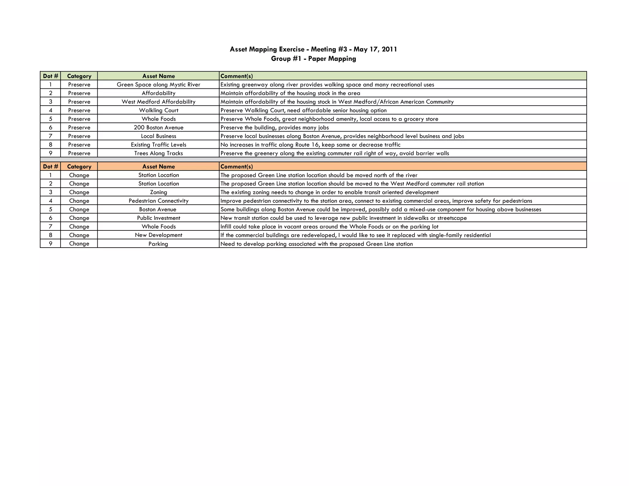
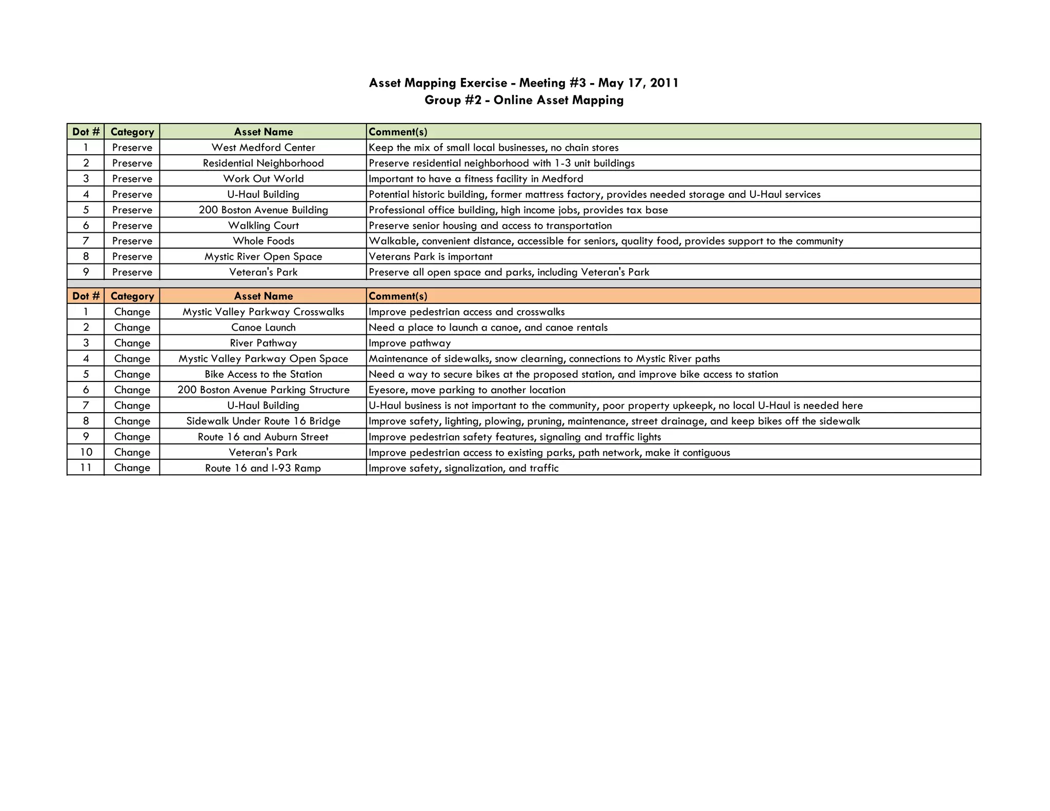
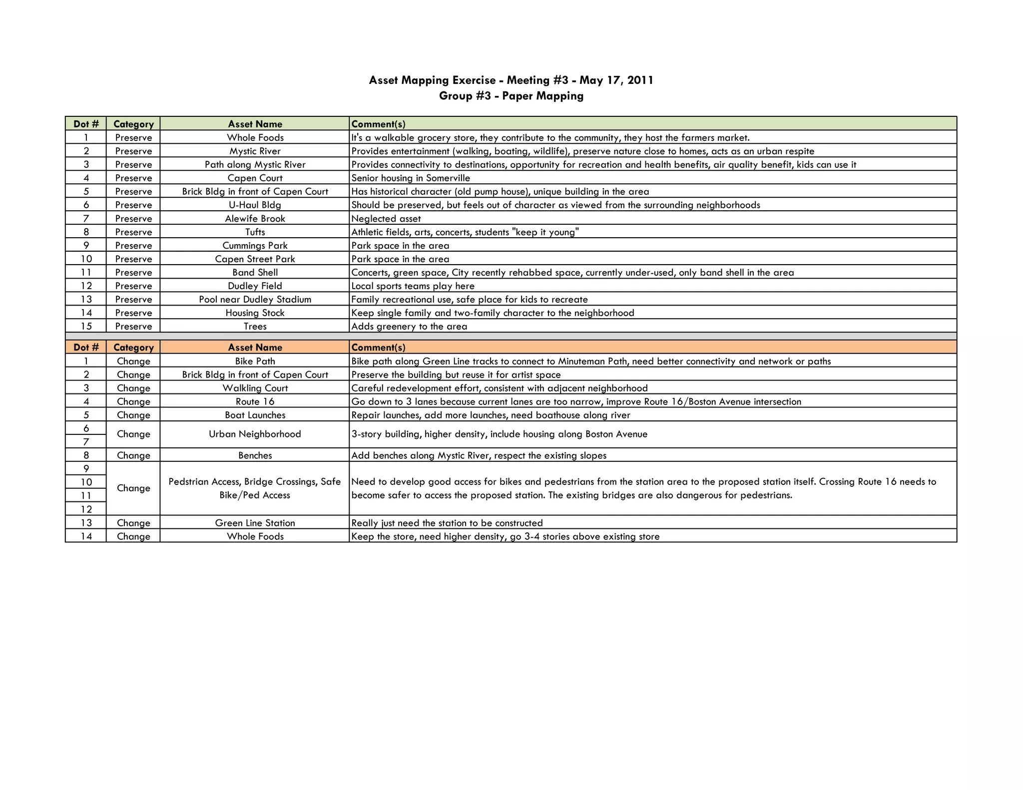
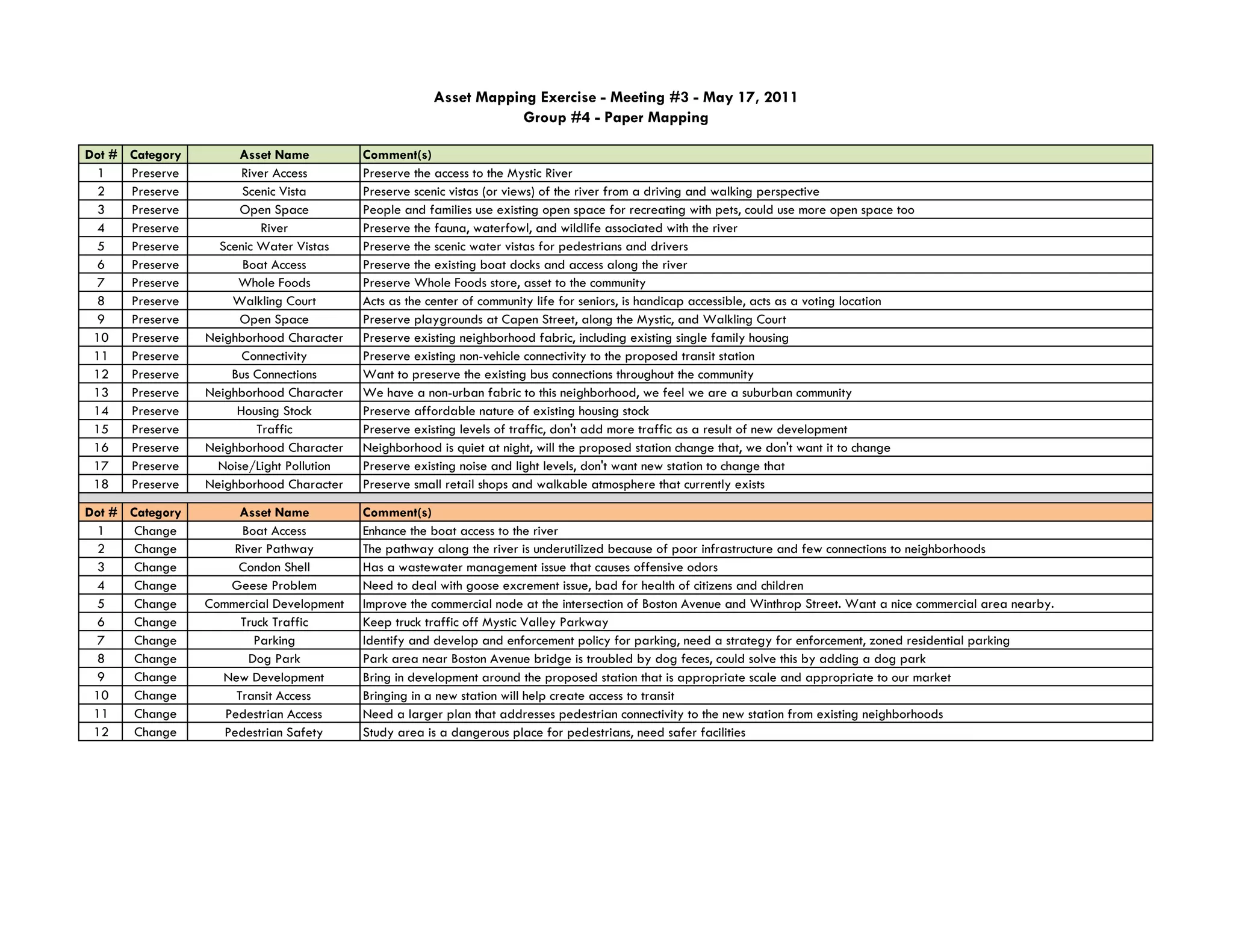
Group 1 mapped assets in the area that should be preserved and changed. Assets to preserve included green space along the Mystic River, affordable housing, local businesses, and existing traffic levels. Assets proposed for change included relocating the proposed Green Line station, improving zoning to allow transit-oriented development, and enhancing pedestrian connectivity.
Group 2 also identified assets to preserve like open spaces, residential neighborhoods, and businesses. Changes proposed included improving crosswalks and pathways along the Mystic River, adding bike infrastructure at the proposed station, and upgrading sidewalks.
Group 3 recommended preserving parks, housing, businesses like Whole Foods, and natural areas. Suggested changes were developing bike networks, improving pedestrian access
The document summarizes the Regional Rail Link project in Victoria which includes 6 work packages to separate regional and metropolitan rail networks. It involves new tracks, stations, bridges and signalling systems from Southern Cross station to West Werribee Junction. Key aspects include two new platforms and 1km of new track at Southern Cross; 4.5km of new track and bridge works between Southern Cross and Maribyrnong River; and 26km of new track with 2 new stations from Deer Park to West Werribee Junction.
This document summarizes an equestrian facility called "Gold Fields" located in Goornong, Victoria, Australia. It has 301 acres that could host various equine events. Facilities include sand and grass arenas, stabling, yards, amenities, and a graded cross-country course. Future plans include developing the space for concerts, festivals, and other outdoor events. The location is central to Victoria and near Bendigo airport and town. The property owner invites clubs and individuals to visit and discuss hosting events at the flexible facility.
Grand Army Plaza: Southeastern Improvementsstreetsblog
The document discusses plans to improve Grand Army Plaza and the surrounding southeastern area in Brooklyn. It outlines changes made from 1999-2007 to improve safety and reduce traffic, including adjusting signals, enlarging pedestrian islands, adding bike lanes, and reducing parking. Future plans as of 2007 included redesigning Eastern Parkway to reduce lanes, adding bike and pedestrian connections between Grand Army Plaza and Prospect Park, and reclaiming unused road space during car-free hours in the park for additional pedestrian space and programming.
The management plan aims to improve Rothwell Country Park over 2014-2016. It analyzes the park's habitats and seeks ways to better incorporate public use while restoring the former coal mining area. The park contains grasslands, woodlands, ponds and the remaining gravel site of the former Fanny Pit. Objectives include removing rubble from the gravel site and turning it into a meadow, improving pathways and adding picnic areas in grasslands, removing invasive plants from woodlands, and monitoring ponds and wetlands to protect fragile species. Annual management will focus on habitat enhancement, path maintenance, and overseeing the park through the Friends of Rothwell Country Park volunteer group.
The document describes several park and recreation projects in Maine towns between 2003 and 2013, including:
- Acton Elementary School playground consolidation and addition of structures in 2003
- Rogers Pond Park entrance/parking paving and picnic pavilion construction in Kennebunk in 2004
- Community center renovation and grounds work in Saco in 2007-2009
- Saco gym renovation including new floor, hoops, and lighting in 2008
- Phoenix Field construction on former landfill in Saco in 2009
- Burns School playground replacement and drainage/safety improvements in Saco in 2013
- Saco parks maintenance building construction for consolidated vehicle storage in 2009
The document discusses erosion issues along the Bârlad River in Vaslui, Romania. It describes heavy erosion on both sides of a bridge, threatening its pillars. It proposes the following solutions:
1) Redirecting the river flow through a new channel on the left bank to stop erosion on the right bank.
2) Consolidating eroded riverbanks with wooden pilings and planting vegetation to stabilize the soil.
3) Using wooden gabions and cables to stabilize a pillar threatened by erosion on the right bank upstream of the bridge.
This document outlines an interlocking paver project in Boothbay, Maine that involved constructing two new walkways, repairing an existing walkway and patio. The project included excavating the base, adding base material, compacting the base, installing pavers in a circle pattern at the intersection of walks and main entrance, and completing the project.
Learn more about the new community of Rowan Park including:
Guiding principles and neighbourbood development.
Visit Experiencerowanpark.ca for more information.
Mabey's shoring system was used to stabilize a cofferdam during construction of a new wastewater pipeline in Port Rodie, Scotland. The cofferdam was needed to protect Scotland's only natural oyster bed in Loch Ryan harbor. Mabey's Super PowerBracePlus bracing system with twin-level bracing and bracing struts withstood the required loading of 14,458 lbs/ft. The new pipeline was installed through the cofferdam to transfer wastewater to the Irish Sea instead of discharging into Loch Ryan, removing threats to the oyster bed.
Whitby Feasibility Study final final 555 final finalEdison Mugoya
The document provides details of a feasibility study conducted by Team 2 for the Coastal Development Consortium to propose developments for the harbour zone of Whitby.
The initial considerations proposed include a park and ride scheme, water sports activities, offshore wind turbines, and improving marina facilities. The three most detailed proposals are a 1,785 space green park and ride located south of Whitby, a multi-functional building at Endeavour Wharf containing educational and leisure facilities, and upgrading the town's bridges including replacing the swing bridge with a new bascule bridge.
The report evaluates each proposal, providing details on design, construction, costs, and environmental and economic impacts. It recommends further development of proposals outside the harbour zone
The document summarizes a project to rehabilitate the historic Jefferson County High School built in 1852 in Monticello, Florida. Helical piles manufactured by CHANCE were used as the deep foundation solution to support the shoring of the existing floor system and roof trusses. The helical piles were chosen because they could be easily installed in the limited access areas and problematic clay soil conditions. The piles ranged from 20-22 feet deep and supported new concrete footings and wood support beams. The helical pile installation was completed in approximately three weeks.
The proposed CRA Park design provides much needed green space and amenities to the underserved neighborhood. However, it lacks a bold identity and fails to differentiate itself from other parks. While the design has positive elements like activities for all ages and community engagement opportunities, it clusters all programmed uses together and lacks clear circulation. The team's vision aims to address these weaknesses by creating a signature three-zone park with adventure playgrounds and a woonerf street to improve safety, traffic, and neighborhood identity.
This document contains architectural project summaries and portfolio pieces by Luis Sotelo including:
1. An international center for awareness of human trafficking that facilitates collaboration through a central glass node providing hope.
2. Renovations to the historic Northern Christian Church providing sustainable strategies like geothermal heating to allow increased community use.
3. A scenic drive overlook in El Paso adding a coffee shop to extend visitor time and deck for safe viewing.
4. A mixed-use townhouse community with 163 units and retail designed around sustainable principles.
5. An interactive STEAM museum in the El Paso arts district incorporating surrounding geometric forms.
Lecture04 AASHTO girder bridge ( Highway Engineering )Hossam Shafiq I
This document discusses the design and repair of pre-stressed concrete girders and structures. It describes jacking up precast concrete girders to replace bearing pads, repairing an overpass by adding a vertical post-tensioning cable, and repairing a cracked pier through horizontal post-tensioning to close vertical cracks.
This document provides an overview of the services offered by Abergeldie, a company that designs and delivers complex infrastructure projects. It discusses their expertise across various sectors including bridges, dams, rail, recreation facilities, energy, water, marine, mining and tunnelling. Abergeldie aims to deliver quality infrastructure and meet client expectations through their professional engineering and flexible project management approach.
Waterbury VT Downtown Planning Study Presentation 2009-10-29.
Please note: This is a work in progress, posted for discussion purposes only. There is discussion in this presentation of how VT's tax increment finance and local option tax work that was included at the request of the committee, and no proposal or recommendation has been made - just a starting point for an important discussion of how these tools could work.
The document discusses plans for renovating the Underwood Pool in Concord, MA. The project goals are to replace the failing pool and outdated bathhouse, create a multi-generational pool, improve accessibility, safety, and landscaping, and enhance connections to the community. The plans include two new bathhouses, two swimming pools, site work, and other amenities at an estimated total project cost of $5.2 million to be funded through the Community Preservation Act and a debt exclusion.
The document outlines a vision to transform the Figueroa Corridor by linking Downtown Los Angeles and USC through street improvements that encourage walking, community cohesion, public transit, and economic development. It identifies three key criteria to achieve this vision: 1) allocating public space fairly for various modes of transportation; 2) designing the street at a human scale with building edges; and 3) making building facades and hubs of activity more inviting to pedestrians. A series of strategies are proposed, including rezonings to create unique districts, establishing public shared spaces, infilling underutilized areas with parks, and engaging the community.
This document discusses repairs needed for a historic concrete bus stop structure located at 4900 Block Broadway & Patterson in San Antonio. It provides background on the structure and outlines the repair and restoration process, costs totaling $48,027 to be funded by the Capital Projects Fund unless VIA approves requested funding. City staff seeks council approval for the repairs.
The document discusses the history of paving and introduces the VIA Pervious Paving System by Commercial Flexspace Inc. It provides details on the system's construction, materials, benefits over concrete and asphalt, and case studies where it has been used successfully for residential and commercial parking lots and driveways. The paving tiles are made of recycled plastic, are permeable, durable, and more cost-effective than traditional paving methods.
Rural Economic Action Plan in Central Oklahoma | 2010reapoklahoma
The purpose of this eReport is to highlight the Rural Economic Action Plan in Central Oklahoma in 2010. REAP is a grant program funded by the Oklahoma Legislature and administered by the Association of Central Oklahoma Governments (ACOG) on behalf of rural communities in Central Oklahoma. Thirty-five REAP grants were awarded in 2010.
Reinforcing steel corrosion can cause concrete spalling and structural damage over time when exposed to deicing salts or marine environments. The document shows 12 photos exemplifying different levels of concrete spalling and rebar corrosion in bridges and highway structures throughout Ontario, Canada that have been subjected to deicing salts and maritime conditions. Maintenance of reinforced concrete structures is important but can also cause traffic disruptions when repairing underlying rebar corrosion and replacing spalled concrete.
This document provides a summary of projects undertaken by Achilles Milioulis including:
- Construction of road, sidewalk, and street lighting networks in Libyan cities totaling $123 million.
- Demolition and construction projects in Illinois totaling $4.5 million, including bridge and airport taxiway construction.
- Infrastructure projects in Libya totaling over $500 million, such as road construction and rehabilitation, sanitary sewer installation, housing development, and industrial construction.
This document provides information on Farrans, a UK-based building and civil engineering contractor. It summarizes some of Farrans' marine portfolio projects, including the construction of a new deep water berth and quay wall at Belfast Harbour, widening of the Seaforth Passage in Liverpool, repairs to a cooling water outfall structure in Heysham, construction of a new harbour wall in Granton, redevelopment of berthing areas and construction of a new quay wall at Montrose Deep Water Berth, construction of Pointhouse Quay in Glasgow, and renewal of Berth 6 in Montrose.
The presentation evaluated two potential sites for the Council for Watershed Health's new headquarters: Block 20 and Block 48/49. Block 20 is located near the LA River and Metro Gold Line in an industrial area known as an "art haven". The vision for Block 20's headquarters included rehabilitating the historic building, adding bioswales for rainwater capture, and developing community spaces. It was seen as an opportunity to demonstrate sustainable redevelopment of an existing building and engage the local artist community.
Clifton Ave Streetscape Report- Spring 2015.compressedJake Henderson
The document summarizes a proposal to redesign Clifton Avenue in Cincinnati, Ohio to improve walkability, connectivity, and balance different transportation modes. The proposal was created by Jake Henderson, Stephanie Godsey, and Nicole Dibble. It includes an analysis of the existing conditions, design criteria focused on balance, safety and eco-design, a proposed street section, master plan and renderings of the redesign. The goal is to transform Clifton Avenue from an automobile-dominated corridor into a multi-modal public space that better connects surrounding neighborhoods and institutions.
The document summarizes discussions from an innovations gathering regarding open spaces projects in Cole Harbour, Nova Scotia. It outlines 4 projects focused on the future use of rehab hospital lands, designing a new barn, identifying a cultural core area, and connecting communities through trail corridors. For each project, participants discussed the roots of the project, ways to make it more complete, next steps, and key learnings. The document aims to capture ideas around enhancing open spaces to preserve heritage, connect places, and make land more versatile for the community.
This document summarizes the update of Marshfield, Massachusetts' Open Space and Recreation Plan. The update analyzed the town's natural and cultural resources and recreation needs to develop a seven-year action plan. The plan highlights lands that protect drinking water supplies, preserve wildlife habitat, and connect existing protected areas. Acquiring additional lands in these areas would increase drinking water protection, protect important species, and connect open spaces to create new trail opportunities. The plan balances conservation and recreation needs to guide the town's protection of environmental resources and provision of diverse recreational activities.
This document summarizes the results of a community planning process in Damariscotta, Maine called the Heart and Soul Planning Project. The project identified community values through public engagement activities. These values centered around working and living locally, access to culture and nature, an involved community, and a sense of community. The document outlines specific action items under each value to guide land use planning and policy changes. Next steps discussed include additional community workshops, drafting code amendments including form-based codes, and a town-wide vote on any proposed code changes.
This document provides an analysis of open space in the Blossom Park precinct of the City of Whittlesea. It finds there is excellent provision of open space, totaling 159.66 hectares or 43% of the precinct area. The available open space per person is 255 square meters. While overall provision is adequate, some gaps in accessibility were identified and the document recommends minor upgrades to several parks to improve paths, facilities, and landscaping. It also recommends a major upgrade of Kellynack Recreation Reserve to include more unstructured recreation areas and informal facilities.
The document provides information on Robin Massingill's landscape architecture education and experience. It includes a resume with details on her bachelor's degree from the University of Arkansas, study abroad program, phone number, email, and website. It also lists previous positions as a resident assistant, teaching assistant, landscape architect intern, and camp counselor. Coursework, leadership roles, and honors are mentioned. At the end are three project summaries: the Cave Springs Ecology Sanctuary, Queensway Elevated Community, and Vestal Urban Farm.
The document summarizes discussions from a visioning gathering regarding open spaces in Cole Harbour. Some key themes discussed include: preserving and enhancing recreation opportunities on the estuary and lakes; improving trail connections between open spaces; ensuring adequate parking and transit access to spaces; protecting natural habitats and scenic views; promoting arts, culture, and community events; and balancing development with preservation of the rural character. Maintaining existing spaces and involving the community were also emphasized.
This document contains a portfolio of work by Kaitlyn Fulton including landscape architecture projects, technical drawings, photographs, and site analysis maps. Some of the landscape architecture projects featured include redesign plans for Edinburgh Plaza parking lot and conceptual designs for the Guelph Innovation District. The portfolio also displays AutoCAD technical drawings, photographs in different genres like wildlife and landscapes, and hand drawings of architectural elements.
The document outlines a plan for the North Main Street Corridor in order to make improvements. It discusses feedback received which focused on making the area more family friendly, beautiful, safe, and affordable. The plan proposes designing the street to be more "livable" by making it easier to cross, calming traffic, adding landscaping, and incorporating spaces for activities. It provides recommendations around reallocating street space, adding crosswalks, curbside parking, landscaping, and connecting side streets to create a more pedestrian-friendly environment. Development opportunities and strategies are discussed to strengthen businesses and attract residents through redevelopment, incentives, and tourism promotions.
The document provides information about an open house for a parks master plan update in View Royal, British Columbia. It discusses updating the 2007 parks plan to enhance and protect parks, encourage residents to be active in parks, address connectivity and upgrades. The open house aims to identify priorities around maintaining character, being environmentally responsible, and providing activities for all ages. It also provides context about View Royal's population growth, demographics, existing parks and trails, and recreational opportunities in the area.
The Wetlands demonstration project would restore degraded wetlands along the Mississippi River and introduce public access. Key elements include:
1) Restoring native plantings and hydrology to create a dynamic wetland landscape along the river.
2) A trail network and boardwalks for public access that traverse high- and low-water zones, allowing exploration of the wetland.
3) An ecological education center to teach about wetland functions and values.
The document discusses plans for flood mitigation and recreation in New Richmond, Ohio. It proposes (1) raising awareness of floodplain regulations through wayfinding signs; (2) utilizing permeable surfaces and native vegetation to respect the environment; and (3) providing educational opportunities about the local river and floodplain. Additionally, it suggests improving connectivity to the river and downtown through walking trails and a pedestrian bridge, and supporting recreation through a skate park, baseball diamond, playground, and connecting trail systems to create a "green loop" around the community.
Miran Day
Independent Work
Year: Spring 2014
04
The site is located in the south of Muncie, which is surrounded by residential area.
The design concept is based on the motion of sports. The curves and lines are
designed to guide people's movement and experience the feeling of sports.
The park contains basketball court, soccer field, baseball field, running track as well
as skate park. Different sports facilities are connected through greenway and paths.
The greenway not only provides the connection but also creates a buffer between
facilities.
The design focuses on the experience of sports. The curves are designed to guide
people's movement and make them feel the power and motion of sports
The document summarizes a public forum to gather community feedback on alternatives and sites being considered for a clean water facility in Oak Harbor, Washington. It provides an overview of the project schedule and decision making criteria involving financial, social, environmental, and technical objectives. Three potential sites - Old City Shops, Beachview Farm, and Windjammer Park - are described and conceptual designs shown. Attendees were asked to provide feedback to help evaluate and select the best alternative and site. The next steps outlined collecting public input, further technical analysis, and presenting a site recommendation to city council for decision.
Over 130 people attended the first public meeting regarding a potential Green Line extension to Mystic Valley Parkway. Participants provided feedback in small groups on key concerns, opportunities, and information needs around transportation, land use, environment, station design/construction, costs, and other issues. Top concerns included traffic, parking, and development scale. Top opportunities included improved transit access and potential for growth. Key information requests centered on traffic impacts, station design, land acquisitions, and project costs. Next steps include a second public meeting in March.
A Permaculture Design for a York PA Old FarmsteadCHEARS
This presentation was prepared as part of a Permaculture Design Certificate (PDC) course. It reviews the history of the farm and presents design ideas for 17 areas of the 35 acre farm established at the end of the 19th Century.
The document discusses plans to redevelop the former Wychwood TTC Barns and Evergreen Brick Works sites in Toronto. It provides details on the vision, partnerships, funding, design concepts, and sustainability features for the projects. The goal is to provide affordable arts and environmental spaces while preserving heritage buildings and demonstrating best practices in sustainability. Key elements include live/work studios, community spaces, gardens, and programming around food, the environment and education.
Similar to GLX meeting 3-Summary of asset mapping (20)
An MIT spinoff called Optimus Ride is developing self-driving vehicle technology. The company was founded by Ryan Chin, a PhD from MIT who worked on several autonomous vehicle projects there. Optimus Ride aims to provide safe, sustainable, and equitable mobility solutions through their technology, which could unlock over $1 trillion in annual savings according to a Morgan Stanley report.
The Mass Drive Clean campaign was created in 2015 using funding from the John Merck Fund to promote electric vehicles (EVs) through test drive events. The campaign was piloted in Massachusetts and San Diego in 2015 and continued in 2016 with local funding. In 2016, the John Merck Fund provided seed funding to expand the campaign into Connecticut and Rhode Island. According to post-test drive surveys, over 70% of participants were more favorably inclined towards EVs and 70% said they were more likely to purchase one after the test drive experience. The next steps of the Mass Drive Clean campaign are to reach a larger, more diverse group of state residents, continue educating about incentives and models, and provide more experiential events
This document summarizes Boston's efforts to research and test autonomous vehicles. It discusses the city's goals of improving safety, access, and mobility. The mayor's office has formed research partnerships and begun testing AVs on city streets. Testing has involved different vehicles and conditions. The document also examines potential AV business models and their impacts. It outlines Boston's work in areas like workforce development and governance to help guide the integration of this new technology.
Electric vehicles (EVs) provide environmental benefits by reducing emissions even when powered by coal-based electricity. EVs also offer lower fuel and maintenance costs compared to gas vehicles. Massachusetts currently has hundreds of EV charging stations and provides incentives for purchasing EVs and installing chargers. Upcoming events will give people test drives to experience EVs firsthand and help more drivers switch to these cleaner vehicles.
The document summarizes an innovative mobility panel at a MAPC Fall Council meeting. The panel discussed the rise of electric vehicles and autonomous vehicles, and how transportation is the largest source of greenhouse gases in Massachusetts. They also addressed critical areas for state and local governments to consider regarding regulatory frameworks, data, land use impacts, infrastructure and parking for new mobility technologies. The panelists represented organizations working on these issues like MAPC, DOER, Optimus Rides, the City of Boston and Reach Strategies.
This document summarizes a presentation on equity in the Metro Boston region. It discusses goals for increasing equity, including reducing segregation, improving access to affordable housing and food, and increasing opportunities for advancement for workers of color. It then reviews trends related to equity across different life stages and demographics since 2011. Key metrics like income inequality, low birth weight, test scores, incarceration rates, labor force participation, and housing cost burden show both improvements in some disparities but also growing inequities in other areas. The presentation concludes that inequity remains significant and is growing, but that policy interventions can help advance equity, though continued work is still needed.
The document provides an overview of Massachusetts' Regulation and Taxation of Marijuana Act, which legalized recreational marijuana use and sales. It discusses the history of medical marijuana in MA, the passage of ballot question 4 in 2016, and outlines the key components of the new law, including allowing personal possession and home cultivation, establishing a regulatory system under the Cannabis Control Commission, implementing licensing for marijuana establishments, and levying a state and local excise tax. A timeline is also presented detailing implementation of the new law between 2017-2019.
1) The document reviews local control options for regulating recreational marijuana establishments under Massachusetts law. It can adopt time, place and manner restrictions or limit numbers through a regulatory referendum.
2) A regulatory referendum requires a ballot question voted on by residents to prohibit establishments, limit retailers to 20% of liquor licenses, or limit numbers to fewer than medical marijuana facilities. However, a consumption referendum can be forced onto the ballot with 10% of voter signatures.
3) Interpretation of some provisions is unclear, such as what constitutes an "area" where medical marijuana facilities operate. Overall municipalities have some local control but face limitations, especially the risk of consumption referendums beyond their direct control.
The document discusses municipal IT collaboration between local governments and school departments. It provides examples of how the Town of Foxborough, MA and Foxborough Public Schools have collaborated on their joint IT operations. They have formed a technology steering committee with stakeholders to identify common needs, prioritize projects, and oversee the shared IT department. The collaboration has allowed them to hire additional IT staff and achieve cost savings while improving services. Overcoming barriers involves managing expectations, communication, and planning for the future.
The document outlines Arlington's IT strategic planning process, including putting together a team, engaging stakeholders, and setting benchmarks. It discusses the core components of the plan, including establishing a vision and mission, inventorying existing IT systems, and defining action steps and measurable outcomes. The plan aims to define the role of the IT department, improve relationships with stakeholders, manage the IT workload, and analyze the network.
The document summarizes the state of IT in Massachusetts government and outlines MassIT's priorities and initiatives to improve digital services. MassIT aims to drive digital transformation across state agencies and support local governments. It discusses findings from an IT review that found low citizen satisfaction with digital services and immature security practices. MassIT plans to invest in core infrastructure, partner with local governments, and facilitate regional collaboration on IT projects and shared services.
We have hired 1 person for IT, saving $25,000 while strengthening our dedicated fiber and adding 24/7 support. IT regionalization has allowed us to hire more staff and save money by sharing resources, making our technology infrastructure more robust with around-the-clock assistance.
Draft recommendations presented by Chris Kuschel of the Metropolitan Area Planning Council at the second public forum of the Natick Center Plan, February 10, 2016, Natick, MA.
The Town of Ashland has a thriving community with engaged residents, businesses, and leaders who work together toward common goals of sustainability, regional collaboration, and excellence in schools. Ashland maintains a strong infrastructure and economy with diverse housing, retail, work, and community spaces. The town is committed to environmental stewardship and transportation options while supporting a vibrant downtown, neighborhoods, and quality of life for all ages and backgrounds.
The Town of Ashland has a thriving community with engaged residents, businesses, and leaders who work together towards common goals of sustainability, regional collaboration, and excellence in education. Ashland maintains a strong infrastructure and economy to support its diverse population with various housing, transportation, employment, and environmental opportunities. The community aims to be sustainable, vibrant, and welcoming to all ages through coordinated efforts outlined in the Ashland Comprehensive Plan.
The document outlines draft land use, housing, economic development, and transportation goals for Ashland. For land use, the top three priorities should be GOAL 1 (accommodate development/preservation through zoning), GOAL 2 (support mixed-use development), and GOAL 3 (consider form-based code). For housing, the top three are GOAL 1 (preserve affordability), GOAL 3 (ensure affordability throughout town), and GOAL 6 (promote diverse/affordable housing). For economic development, the top three are GOAL 1 (vibrant development along corridors/downtown), GOAL 2 (provide planning/technical assistance), and GOAL 3 (implement public facilities/utilities
The document summarizes a community forum held in Ashland, Massachusetts to discuss updating the town's comprehensive plan. It provides an overview of the comprehensive planning process and progress made so far in developing Ashland's plan, including outreach activities and draft goals in key areas like land use, housing, economic development, and transportation. The forum included a presentation of the draft community vision statement and goals, followed by small group discussions for residents to provide input and prioritize goals to guide future growth. The next steps in the planning process were also outlined.
The document summarizes a plan for Natick Center that incorporates previous planning efforts and public input. Some key points:
- Previous plans from 1980-2000s addressed facilities, parking, and design issues.
- Natick's population is growing and its households are shrinking, increasing demand for multi-family and smaller housing units.
- New developments have contributed students to schools, though less than single-family homes typically.
- Most people walk to the commuter rail station, and ridership has increased in recent years.
- The plan gathers public input on housing, retail, transportation, and parking preferences to develop a vision for Natick Center's future.
The document provides information from MAPC's Fall 2015 Council meeting. It includes summaries and data from several MAPC projects:
- An inventory of 169 MAPC projects from the past year that advance MetroFuture goals such as sustainable growth, housing, and transportation. Transportation and healthy environment were the most common project categories.
- A discussion of regional ballot initiatives to raise funds for transportation projects and how Massachusetts municipalities can pursue similar initiatives.
- A project to engage immigrant small business owners in downtown Framingham through outreach efforts and a business owner story tour.
- Planning work in Chelsea around housing, jobs, and health through the lens of equity and quality of life near transit infrastructure.
- A project in Quin
1. Asset Mapping Exercise - Meeting #3 - May 17, 2011
Group #1 - Paper Mapping
Dot # Category Asset Name Comment(s)
1 Preserve Green Space along Mystic River Existing greenway along river provides walking space and many recreational uses
2 Preserve Affordability Maintain affordability of the housing stock in the area
3 Preserve West Medford Affordability Maintain affordability of the housing stock in West Medford/African American Community
4 Preserve Walkling Court Preserve Walkling Court, need affordable senior housing option
5 Preserve Whole Foods Preserve Whole Foods, great neighborhood amenity, local access to a grocery store
6 Preserve 200 Boston Avenue Preserve the building, provides many jobs
7 Preserve Local Business Preserve local businesses along Boston Avenue, provides neighborhood level business and jobs
8 Preserve Existing Traffic Levels No increases in traffic along Route 16, keep same or decrease traffic
9 Preserve Trees Along Tracks Preserve the greenery along the existing commuter rail right of way, avoid barrier walls
Dot # Category Asset Name Comment(s)
1 Change Station Location The proposed Green Line station location should be moved north of the river
2 Change Station Location The proposed Green Line station location should be moved to the West Medford commuter rail station
3 Change Zoning The existing zoning needs to change in order to enable transit oriented development
4 Change Pedestrian Connectivity Improve pedestrian connectivity to the station area, connect to existing commercial areas, improve safety for pedestrians
5 Change Boston Avenue Some buildings along Boston Avenue could be improved, possibly add a mixed-use component for housing above businesses
6 Change Public Investment New transit station could be used to leverage new public investment in sidewalks or streetscape
7 Change Whole Foods Infill could take place in vacant areas around the Whole Foods or on the parking lot
8 Change New Development If the commercial buildings are redeveloped, I would like to see it replaced with single-family residential
9 Change Parking Need to develop parking associated with the proposed Green Line station
2. Asset Mapping Exercise - Meeting #3 - May 17, 2011
Group #2 - Online Asset Mapping
Dot # Category Asset Name Comment(s)
1 Preserve West Medford Center Keep the mix of small local businesses, no chain stores
2 Preserve Residential Neighborhood Preserve residential neighborhood with 1-3 unit buildings
3 Preserve Work Out World Important to have a fitness facility in Medford
4 Preserve U-Haul Building Potential historic building, former mattress factory, provides needed storage and U-Haul services
5 Preserve 200 Boston Avenue Building Professional office building, high income jobs, provides tax base
6 Preserve Walkling Court Preserve senior housing and access to transportation
7 Preserve Whole Foods Walkable, convenient distance, accessible for seniors, quality food, provides support to the community
8 Preserve Mystic River Open Space Veterans Park is important
9 Preserve Veteran's Park Preserve all open space and parks, including Veteran's Park
Dot # Category Asset Name Comment(s)
1 Change Mystic Valley Parkway Crosswalks Improve pedestrian access and crosswalks
2 Change Canoe Launch Need a place to launch a canoe, and canoe rentals
3 Change River Pathway Improve pathway
4 Change Mystic Valley Parkway Open Space Maintenance of sidewalks, snow clearning, connections to Mystic River paths
5 Change Bike Access to the Station Need a way to secure bikes at the proposed station, and improve bike access to station
6 Change 200 Boston Avenue Parking Structure Eyesore, move parking to another location
7 Change U-Haul Building U-Haul business is not important to the community, poor property upkeepk, no local U-Haul is needed here
8 Change Sidewalk Under Route 16 Bridge Improve safety, lighting, plowing, pruning, maintenance, street drainage, and keep bikes off the sidewalk
9 Change Route 16 and Auburn Street Improve pedestrian safety features, signaling and traffic lights
10 Change Veteran's Park Improve pedestrian access to existing parks, path network, make it contiguous
11 Change Route 16 and I-93 Ramp Improve safety, signalization, and traffic
3. Asset Mapping Exercise - Meeting #3 - May 17, 2011
Group #3 - Paper Mapping
Dot # Category Asset Name Comment(s)
1 Preserve Whole Foods It's a walkable grocery store, they contribute to the community, they host the farmers market.
2 Preserve Mystic River Provides entertainment (walking, boating, wildlife), preserve nature close to homes, acts as an urban respite
3 Preserve Path along Mystic River Provides connectivity to destinations, opportunity for recreation and health benefits, air quality benefit, kids can use it
4 Preserve Capen Court Senior housing in Somerville
5 Preserve Brick Bldg in front of Capen Court Has historical character (old pump house), unique building in the area
6 Preserve U-Haul Bldg Should be preserved, but feels out of character as viewed from the surrounding neighborhoods
7 Preserve Alewife Brook Neglected asset
8 Preserve Tufts Athletic fields, arts, concerts, students "keep it young"
9 Preserve Cummings Park Park space in the area
10 Preserve Capen Street Park Park space in the area
11 Preserve Band Shell Concerts, green space, City recently rehabbed space, currently under-used, only band shell in the area
12 Preserve Dudley Field Local sports teams play here
13 Preserve Pool near Dudley Stadium Family recreational use, safe place for kids to recreate
14 Preserve Housing Stock Keep single family and two-family character to the neighborhood
15 Preserve Trees Adds greenery to the area
Dot # Category Asset Name Comment(s)
1 Change Bike Path Bike path along Green Line tracks to connect to Minuteman Path, need better connectivity and network or paths
2 Change Brick Bldg in front of Capen Court Preserve the building but reuse it for artist space
3 Change Walkling Court Careful redevelopment effort, consistent with adjacent neighborhood
4 Change Route 16 Go down to 3 lanes because current lanes are too narrow, improve Route 16/Boston Avenue intersection
5 Change Boat Launches Repair launches, add more launches, need boathouse along river
6
Change Urban Neighborhood 3-story building, higher density, include housing along Boston Avenue
7
8 Change Benches Add benches along Mystic River, respect the existing slopes
9
10 Pedstrian Access, Bridge Crossings, Safe Need to develop good access for bikes and pedestrians from the station area to the proposed station itself. Crossing Route 16 needs to
Change
11 Bike/Ped Access become safer to access the proposed station. The existing bridges are also dangerous for pedestrians.
12
13 Change Green Line Station Really just need the station to be constructed
14 Change Whole Foods Keep the store, need higher density, go 3-4 stories above existing store
4. Asset Mapping Exercise - Meeting #3 - May 17, 2011
Group #4 - Paper Mapping
Dot # Category Asset Name Comment(s)
1 Preserve River Access Preserve the access to the Mystic River
2 Preserve Scenic Vista Preserve scenic vistas (or views) of the river from a driving and walking perspective
3 Preserve Open Space People and families use existing open space for recreating with pets, could use more open space too
4 Preserve River Preserve the fauna, waterfowl, and wildlife associated with the river
5 Preserve Scenic Water Vistas Preserve the scenic water vistas for pedestrians and drivers
6 Preserve Boat Access Preserve the existing boat docks and access along the river
7 Preserve Whole Foods Preserve Whole Foods store, asset to the community
8 Preserve Walkling Court Acts as the center of community life for seniors, is handicap accessible, acts as a voting location
9 Preserve Open Space Preserve playgrounds at Capen Street, along the Mystic, and Walkling Court
10 Preserve Neighborhood Character Preserve existing neighborhood fabric, including existing single family housing
11 Preserve Connectivity Preserve existing non-vehicle connectivity to the proposed transit station
12 Preserve Bus Connections Want to preserve the existing bus connections throughout the community
13 Preserve Neighborhood Character We have a non-urban fabric to this neighborhood, we feel we are a suburban community
14 Preserve Housing Stock Preserve affordable nature of existing housing stock
15 Preserve Traffic Preserve existing levels of traffic, don't add more traffic as a result of new development
16 Preserve Neighborhood Character Neighborhood is quiet at night, will the proposed station change that, we don't want it to change
17 Preserve Noise/Light Pollution Preserve existing noise and light levels, don't want new station to change that
18 Preserve Neighborhood Character Preserve small retail shops and walkable atmosphere that currently exists
Dot # Category Asset Name Comment(s)
1 Change Boat Access Enhance the boat access to the river
2 Change River Pathway The pathway along the river is underutilized because of poor infrastructure and few connections to neighborhoods
3 Change Condon Shell Has a wastewater management issue that causes offensive odors
4 Change Geese Problem Need to deal with goose excrement issue, bad for health of citizens and children
5 Change Commercial Development Improve the commercial node at the intersection of Boston Avenue and Winthrop Street. Want a nice commercial area nearby.
6 Change Truck Traffic Keep truck traffic off Mystic Valley Parkway
7 Change Parking Identify and develop and enforcement policy for parking, need a strategy for enforcement, zoned residential parking
8 Change Dog Park Park area near Boston Avenue bridge is troubled by dog feces, could solve this by adding a dog park
9 Change New Development Bring in development around the proposed station that is appropriate scale and appropriate to our market
10 Change Transit Access Bringing in a new station will help create access to transit
11 Change Pedestrian Access Need a larger plan that addresses pedestrian connectivity to the new station from existing neighborhoods
12 Change Pedestrian Safety Study area is a dangerous place for pedestrians, need safer facilities