Download to read offline
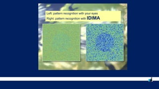
![© PROGIS Technologies 15
IDIMA [ IDentification of IMAges ]
WINGIS + BING + IDIMA](https://image.slidesharecdn.com/gi2016pptmayercopernicusdresden-161113091041/85/GI2016-ppt-mayer-copernicus_dresden-15-320.jpg)
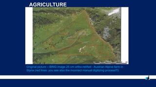
![© PROGIS Technologies 16
IDIMA [ IDentification of IMAges ]
WINGIS + BING + IDIMA](https://image.slidesharecdn.com/gi2016pptmayercopernicusdresden-161113091041/85/GI2016-ppt-mayer-copernicus_dresden-16-320.jpg)
![© PROGIS Technologies 17
IDIMA [ IDentification of IMAges ]
WINGIS + BING + IDIMA](https://image.slidesharecdn.com/gi2016pptmayercopernicusdresden-161113091041/85/GI2016-ppt-mayer-copernicus_dresden-17-320.jpg)
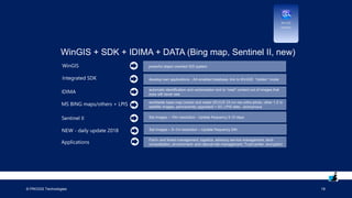

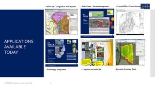
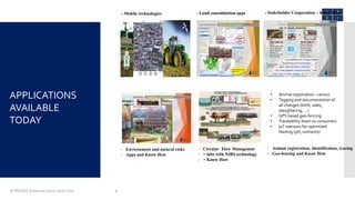
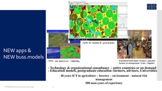
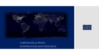
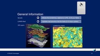
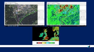
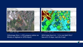
This document contains information about PROGIS Technologies and their products and services related to geographic information systems (GIS) and precision farming. It discusses their WinGIS software, which allows users to manage location data, as well as their LUMEN Real product that monitors crop growth using data from the Sentinel-II satellite. The document also describes PROGIS' IDIMA technology for automated image pattern recognition and digitization. PROGIS has over 40 years of experience in agriculture, forestry, environment and natural risk management.


![[DSC DACH 25] AI in Action_ From Industrial Data to Sustainable Impact_Ashraf...](https://cdn.slidesharecdn.com/ss_thumbnails/aiinactionfromindustrialdatatosustainableimpactashrafabushady20251016-251024080148-05e79a02-thumbnail.jpg?width=640&height=640&fit=bounds)


![[Day 1] Welcome, Looking Back, and Agenda](https://cdn.slidesharecdn.com/ss_thumbnails/cgiar-csi-day1-31mar2009-welcome-lookingbackandagenda-090405003623-phpapp01-thumbnail.jpg?width=640&height=640&fit=bounds)


![5G Explained! A High Level Overview [Introduction]](https://cdn.slidesharecdn.com/ss_thumbnails/5gexplainedahighleveloverview-260119165306-cc137a3e-thumbnail.jpg?width=640&height=640&fit=bounds)


