Geotechnical Mapping with Airborne EM
•
1 like•198 views

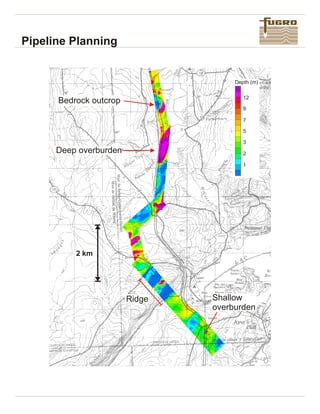
Fugro Airborne Surveys conducted a helicopter electromagnetic survey along a 130km prospective pipeline corridor to map ground conditions and aid in pipeline planning. The survey took two days and produced maps with 10m resolution showing the depth to bedrock and extent of overburden, which helps determine construction methods and reduce costs. The results identified shallow bedrock requiring blasting and deeper soils that could be trenched. A cross-section map provided additional depth information along the central flight line to aid in planning.

Recommended
More Related Content
What's hot
What's hot (10)
Similar to Geotechnical Mapping with Airborne EM
Similar to Geotechnical Mapping with Airborne EM (20)
More from Brett Johnson
More from Brett Johnson (20)
Recently uploaded
Recently uploaded (20)
Geotechnical Mapping with Airborne EM
- 1. Pipeline Planning Shallow overburden Ridge Deep overburden Bedrock outcrop 2 km Depth (m) 5 1 2 12 3 7 9
- 2. Pipeline Planning FUGRO AIRBORNE SURVEYS Ottawa 2060 Walkley Road Ontario, Canada K1G 3P5 Phone Fax Email :1-613-731-9575 :1-613-731-0453 :postmaster@geoterrex.ca :1-905-812-0212 :1-905-812-1504 :dighem@dighem.com Toronto 2270 Argentia Road, Unit 2 Mississauga, Ontario, Canada L5N 6A6 Phone Fax Email Fugro Airborne Surveys is a member of the Fugro Group, with offices throughout the world. 0 10m Pipe Depth 1 km Overburden Bedrock N Helicopter EM surveys have been borderline between soils, which used to map apparentconductivity could be trenched, and rock which as an aid to characterizing ground would have to be blasted. The conditions in advance of pipeline data can be mathematically construction. The cost of pipeline inverted to produce maps of the construction is strongly dependent depth to bedrock, as shown on the on the ground conditions front. en co un te re d, an d ac cu ra te The calculated depth to bedrock prediction of these conditions can can also be presented as a reduce the planning risk geological cross-section, shown considerably. on this page. This section is V A DIGHEM conductivity survey derived from the depth information was used to map ground along the central flight line(s) of the conditions along approximately map shown on the front. 130km of prospective pipeline The airborne EM survey reduced corridor, 400m in width. The the time and cost associated with survey took about two days to gaining land access and complete, providing a map of permission for drilling. The survey apparent conductivity with a also served as a check for buried, resolution of approximately 10m. unknown power lines and The results are interpreted to pipelines. Airborne EM surveys determine the extent of shallow have also been used to map bedrock (which would require ground conductivity after the blasting) and deeper overburden pipelines have been constructed which could be trenched to the to detect areas of high ground depth necessary for the pipeline. conductivity due to clays or saline Over much of the survey area it is soils. These soils can create possible to define a single conditions in which pipeline apparent conductivity value as the corrosion isaccelerated.