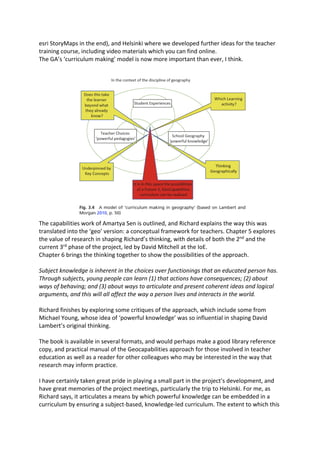
1) The document summarizes Richard Bustin's book "Geography Educationâs Potential and the Capability Approach" which outlines the development of the GeoCapabilities project that aimed to develop teachers' curriculum making skills.
2) It describes Richard's involvement in the project as a school partner and how he used it as the basis for his research exploring how the capabilities approach could influence geography curriculum development.
3) The capabilities approach developed by Amartya Sen is translated into a "geo" version as a conceptual framework for teachers to develop students' functioning and agency through geographical knowledge.
Place-Based Learning and the Language ClassroomDave Malinowski
Â
A presentation and workshop for the Yale Center for Language Study's Instructional Innovation Workshop, May 17, 2016. By StĂŠphane Charitos (Columbia University) and David Malinowski (Yale University)
geography.org.uk 1 Reading for trainee teachers .docxgreg1eden90113
Â
geography.org.uk
1
Reading for trainee teachers and NQTs
The value of geography
(Extract from: Day, A. âGeography: Challenges for its next centuryâ, Teaching Geography, April 1995)
âGeography - along with history - has a central role to play in helping to develop articulate, objective
and informed citizens. Schools have never been (could never be!) simply about fitting students for
the world of work. The broad and balanced curriculum means equipping the twenty-first century
citizen to become a fully effective and responsible participant in local, national and global
communities. Participatory democracies have to be worked at, and the preparation comes to a large
extent from the content and approach of subjects like geography.
But the strongest justification for retaining geography and active geographers is the type of world
we and our successors will inhabit in the twenty first century. As demographic and resource
pressures intensify; as environmental and ecological issues become more critical; as conflicts of land-
use multiply; and as the need to manage and plan the increasingly complex web of human and
environmental interactions over the surface of the planet become more urgent, then geographers
should increasingly be at the forefront of analysing what's going on, explaining why, and proposing
alternative strategies with an accountant's precision in detailing the costs and benefits of each
possible scenario. I do not think we need to be pessimistic when we consider the world we inhabit in
the future - much will be positive and of benefit. It would be pessimistic, however, to assume that
geographers will not be fully employed in advising the decision-makers of the likely environmental
impact of their decisions in human, physical and regional dimensions.
There is, however, an intervening stage which is necessary for the scenario above to become a
possibility, and that is for general acknowledgement of the contributions geography can make to
become recognised and accorded value. At the moment I do not feel that this is the case. Geography
is either deemed to be "valuable" - because it informs you where places are and what they are like;
or "interesting" - because it deals with topical issues such as rain forest destruction. At year 9
parents' evenings it is nearly always a combination of these two reasons which makes parents
consider the subject a reasonable one for their daughter or son to pursue at GCSE. And 1 guess I go
along with them as I stress the importance of a student being interested in a subject to provide the
necessary motivation to obtain a good grade at the end of the course.
But if I talk about the "value" of the subject, it is often narrowly understood in terms of its value to
the tourism industry or, at a stretch, cartography. We are hard-pressed to come up with any other
areas in which geography, as it is popularly perceived, is put into direct practic.
INTRODUCING GEOGRAPHY AND READING MAP SKILLS TO KINDERGARTEN CHILDREN BY USIN...ijejournal
Â
The construction of space in children develops gradually, as they grow up and is related both to their
environment and to their spatial and/or geographical experiences. According to previous studies, spatial
thinking is malleable, and can be developed with the use of appropriate teaching interventions and
educational material. Geospatial thinking and reading map skills required to decode map symbols are a
relatively new and very interesting topic in kindergartenâs education. Significance of this study is the
creation of two large-scale giant maps, laminated, and appropriate to accompany teaching material that
can be used in a teaching intervention based on the Greek kindergarten curriculum. The first map (scale of
1:1000) is a map of the city of Mytilene, and the second one (scale of 1:20000) is of the island of Lesvos;
both have dimensions 3X4 meters. The purpose of this study is to present the creation of spatial teaching
material, so that map skills in Kindergarten education can be cultivated and developed in order to provide
kindergarten teachers with large scale-giant maps and encourage them to introduce them to their teaching,
as large scale-giant maps are really powerful educational tools for the development of their pupilsâ spatial
skills.
A summary of the key concepts involved in the GeoCapabilities teacher training course. It addresses capabilities and Geography, Powerful Disciplinary Knowledge, curriculum making and leadership
Geocapabilities3: teaching social justice, EUROGEO 2021 conference 22-23 Apr...Luc Zwartjes
Â
The intention of GeoCapabilities 3 is to support teachers in developing their curriculum making capacity and in so doing enable them to engage with important curriculum questions such as what kinds of geographical knowledge are taught in schools, who decides and why, and what kinds of pedagogies are needed to teach powerful disciplinary knowledge (PDK) to students.
Social Justice is the concept that will underpin the work of the project. Whilst it is a concept that has been much examined in education more generally (Unterhalter and Brighouse, 2015), work pertaining to a socially just geography curriculum is limited. Weeden (2012) reports on significant inequalities in young peopleâs access to geography education in inner city communities in England.
GeoCapabilities 3 seeks to answer 2 main questions:
1. Is there a social justice dimension to GeoCapabilities? and:
2. How can a GeoCapabilities approach benefit schools (teachers/ pupils) in challenging (socio-economic) circumstances towards the goal of âpowerful knowledge for all?
Education for Sustainable Development in the Schoolyards
`
For more information, Please see websites below:
`
Organic Edible Schoolyards & Gardening with Children
http://scribd.com/doc/239851214
`
Double Food Production from your School Garden with Organic Tech
http://scribd.com/doc/239851079
`
Free School Gardening Art Posters
http://scribd.com/doc/239851159`
`
Companion Planting Increases Food Production from School Gardens
http://scribd.com/doc/239851159
`
Healthy Foods Dramatically Improves Student Academic Success
http://scribd.com/doc/239851348
`
City Chickens for your Organic School Garden
http://scribd.com/doc/239850440
`
Simple Square Foot Gardening for Schools - Teacher Guide
http://scribd.com/doc/239851110
Sustainable Development Goals Challenges in mapping our world with geography ...Karl Donert
Â
A presentation given at the Bilingual Geography teacher training course examining the Sustainable Development Goals. The presentation examines approaches and methods suited to innovative learning and teaching.
Presentation at the PLE Conference 2013 - Berlin (10-12th July, 2013)
Personal Learning Environments (PLEs) only seems to be personal, but from a practice-oriented view it is an ongoing process of social interactions and negotiations. In this presentation I talked about why context matters, outlined views on context and their implications for developing pedagogical concepts. This is part of my dissertation. The title of this presentation provokates, but shows the contradictions between the aspects "personal", social and materiality. These aspects should be considered when we are talking about and doing research of PLEs.
Find the Videorecording here: http://youtu.be/7JViJHzqWG0
Biological screening of herbal drugs: Introduction and Need for
Phyto-Pharmacological Screening, New Strategies for evaluating
Natural Products, In vitro evaluation techniques for Antioxidants, Antimicrobial and Anticancer drugs. In vivo evaluation techniques
for Anti-inflammatory, Antiulcer, Anticancer, Wound healing, Antidiabetic, Hepatoprotective, Cardio protective, Diuretics and
Antifertility, Toxicity studies as per OECD guidelines
it describes the bony anatomy including the femoral head , acetabulum, labrum . also discusses the capsule , ligaments . muscle that act on the hip joint and the range of motion are outlined. factors affecting hip joint stability and weight transmission through the joint are summarized.
Read| The latest issue of The Challenger is here! We are thrilled to announce that our school paper has qualified for the NATIONAL SCHOOLS PRESS CONFERENCE (NSPC) 2024. Thank you for your unwavering support and trust. Dive into the stories that made us stand out!
A workshop hosted by the South African Journal of Science aimed at postgraduate students and early career researchers with little or no experience in writing and publishing journal articles.
June 3, 2024 Anti-Semitism Letter Sent to MIT President Kornbluth and MIT Cor...Levi Shapiro
Â
Letter from the Congress of the United States regarding Anti-Semitism sent June 3rd to MIT President Sally Kornbluth, MIT Corp Chair, Mark Gorenberg
Dear Dr. Kornbluth and Mr. Gorenberg,
The US House of Representatives is deeply concerned by ongoing and pervasive acts of antisemitic
harassment and intimidation at the Massachusetts Institute of Technology (MIT). Failing to act decisively to ensure a safe learning environment for all students would be a grave dereliction of your responsibilities as President of MIT and Chair of the MIT Corporation.
This Congress will not stand idly by and allow an environment hostile to Jewish students to persist. The House believes that your institution is in violation of Title VI of the Civil Rights Act, and the inability or
unwillingness to rectify this violation through action requires accountability.
Postsecondary education is a unique opportunity for students to learn and have their ideas and beliefs challenged. However, universities receiving hundreds of millions of federal funds annually have denied
students that opportunity and have been hijacked to become venues for the promotion of terrorism, antisemitic harassment and intimidation, unlawful encampments, and in some cases, assaults and riots.
The House of Representatives will not countenance the use of federal funds to indoctrinate students into hateful, antisemitic, anti-American supporters of terrorism. Investigations into campus antisemitism by the Committee on Education and the Workforce and the Committee on Ways and Means have been expanded into a Congress-wide probe across all relevant jurisdictions to address this national crisis. The undersigned Committees will conduct oversight into the use of federal funds at MIT and its learning environment under authorities granted to each Committee.
⢠The Committee on Education and the Workforce has been investigating your institution since December 7, 2023. The Committee has broad jurisdiction over postsecondary education, including its compliance with Title VI of the Civil Rights Act, campus safety concerns over disruptions to the learning environment, and the awarding of federal student aid under the Higher Education Act.
⢠The Committee on Oversight and Accountability is investigating the sources of funding and other support flowing to groups espousing pro-Hamas propaganda and engaged in antisemitic harassment and intimidation of students. The Committee on Oversight and Accountability is the principal oversight committee of the US House of Representatives and has broad authority to investigate âany matterâ at âany timeâ under House Rule X.
⢠The Committee on Ways and Means has been investigating several universities since November 15, 2023, when the Committee held a hearing entitled From Ivory Towers to Dark Corners: Investigating the Nexus Between Antisemitism, Tax-Exempt Universities, and Terror Financing. The Committee followed the hearing with letters to those institutions on January 10, 202
Executive Directors Chat Leveraging AI for Diversity, Equity, and InclusionTechSoup
Â
Letâs explore the intersection of technology and equity in the final session of our DEI series. Discover how AI tools, like ChatGPT, can be used to support and enhance your nonprofit's DEI initiatives. Participants will gain insights into practical AI applications and get tips for leveraging technology to advance their DEI goals.
A review of the growth of the Israel Genealogy Research Association Database Collection for the last 12 months. Our collection is now passed the 3 million mark and still growing. See which archives have contributed the most. See the different types of records we have, and which years have had records added. You can also see what we have for the future.
A Strategic Approach: GenAI in EducationPeter Windle
Â
Artificial Intelligence (AI) technologies such as Generative AI, Image Generators and Large Language Models have had a dramatic impact on teaching, learning and assessment over the past 18 months. The most immediate threat AI posed was to Academic Integrity with Higher Education Institutes (HEIs) focusing their efforts on combating the use of GenAI in assessment. Guidelines were developed for staff and students, policies put in place too. Innovative educators have forged paths in the use of Generative AI for teaching, learning and assessments leading to pockets of transformation springing up across HEIs, often with little or no top-down guidance, support or direction.
This Gasta posits a strategic approach to integrating AI into HEIs to prepare staff, students and the curriculum for an evolving world and workplace. We will highlight the advantages of working with these technologies beyond the realm of teaching, learning and assessment by considering prompt engineering skills, industry impact, curriculum changes, and the need for staff upskilling. In contrast, not engaging strategically with Generative AI poses risks, including falling behind peers, missed opportunities and failing to ensure our graduates remain employable. The rapid evolution of AI technologies necessitates a proactive and strategic approach if we are to remain relevant.
MATATAG CURRICULUM: ASSESSING THE READINESS OF ELEM. PUBLIC SCHOOL TEACHERS I...NelTorrente
Â
In this research, it concludes that while the readiness of teachers in Caloocan City to implement the MATATAG Curriculum is generally positive, targeted efforts in professional development, resource distribution, support networks, and comprehensive preparation can address the existing gaps and ensure successful curriculum implementation.
MATATAG CURRICULUM: ASSESSING THE READINESS OF ELEM. PUBLIC SCHOOL TEACHERS I...
Â
GeoCapabilities Book Review
1. âGeography Educationâs Potential and the Capability Approachâ
Richard Bustin
Palgrave Macmillan, 2019
978-3-030-25641-8
In September 2014. I was contacted by Professor David Lambert to see
if I had the time to be involved in an ERASMUS funded project. As I
was working part time at Kingâs Ely at the time, I was able to commit
some time and explore more about the project which was called
âGeoCapabilitiesâ. I ended up as a freelance worker with UCL Institute
of Education for the next 18 months.
A few years earlier, in 2012 I had co-presented with Michael Solem, of the AAG and John
Lyon at the GA conference on the outcomes of an ERASMUS+ funded project called
digitalearth, which introduced the idea of geomedia, which we defined as: âany media that
uses the spatial localisation of informationâ.
Michael and the AAG were also involved in significant work to shape geography education in
the USA, with the publication of the âRoad map for Geographyâ being one of the important
documents at the time:
http://media.nationalgeographic.org/assets/file/NGS_RoadMapIMPDReport_6-21.pdf
There was reference made during our very well attended GA Conference session to the
work of the AAG developing the idea of a capabilities model around the work of Amartya
Sen, a Nobel prize winning economist with a project called âGeoCapabilitiesâ, funded by the
US National Science Foundation: http://www.aag.org/geocapabilities
The new project was a development of one started by the AAG, and which Michael and
David had been working on along with Professor Sirpa Tani from Helsinki University. This
first phase http://www.aag.org/geocapabilities had the focus of âUnderstanding capabilities
in teaching geographyâ.
The project Richard got involved with was Stage 2 of GeoCapabilities, and gained ERASMUS+
funding from the EU. The projectâs website can be found here, and had a focus on âTeachers
as curriculum leadersâ: http://www.geocapabilities.org/geocapabilities-2/
Richard was involved in the project as one of the school partners, and used it as the basis for
some research.
Richard has outlined the development of the project along with his involvement in it in the
book, which explores the origins of the idea of capabilities.
As David has said although the official curriculum is no guarantee for what is taught, it is
specialist teachers who can, notwithstanding the various influences and pressures they are
under, take responsibility to design and make convincing and engaging lessons. To do this
they need to know why it is worth teaching the subject.
Asking the question âin what way is geographical knowledge powerful?â is a good way to
clarify the value of teaching geography. This process, which we developed during my time
working for the Geographical Association is called âcurriculum makingâ.
2. In the preface, Richard talks about his own early school experiences of geography, and his
own great-grandfather Alfred Bray Treloar, who understood the importance of getting
young people out of the classroom to reflect on their surroundings.
The book explores the background to the approach, and moves into the âcapabilities
approachâ and its connection with a Futures 3 approach drawn from the work of Michael
Young, someone I have seen several times speaking about his notion of âpowerful
knowledgeâ.
Richard has shared his own (successful) journey towards his MA in Geography Education,
and later his PhD in the book, which explores the way that the capabilities approach could
(and already does) influence curriculum development in secondary geography education.
This came out of a frustration with the simplicity of some areas of geography such as urban
land use models, following his undergraduate work, and his work to put some of the
complexity back in.
He begins by explaining the beginnings of the capabilities approach and connects it with
geography education, connecting with Margaret Robertsâ important observation (2010) that
she had observed a lot of geography lessons which had very little geography in them. He
references the work done to identify the âpurposeâ of school geography, and the work we
completed at the GA on our manifesto for school geography called âa different viewâ.
Along the way, Richard provides a clear exposition on the development of both âcurriculumâ
and âpedagogyâ. He provides a useful thought from Beck and Earl (2003), who offered a
series of principles for selection of content as âany curriculum is a selection from all the
worthwhile knowledge which school could potentially transmitâ. This selection is an
important decision for every teacher to make. Richard mentions the important work of
Eleanor Rawling in this regard, and also Basil Bernstein on curriculum âframingâ and
ârecontextualisationâ.
He explores different âknowledgesâ and the differences between F1, F2 and F3 (future 3)
curricula. Check out Richardâs articles from âTeaching Geographyâ on these themes to see
more of his thinking articulated as it developed, and also the work of Alaric Maude in this
area.
There is important thinking here too on what makes something âgeographicalâ.
âA map on its own, however, is not distinctly geographical as other subjects can use them in
their discourse. It is how maps are used to enhance geographical knowledge and
understanding that makes them geographical. Balchin (a former GA President) and Colman
(1971) described this skill as âgraphicacyâ, and the ability to represent, interpret and analyse
information cartographically can be seen to be a geographical skill, and this includes both
traditional and digital mapping such as Geographical Information Systems (GIS)â.
He moves on to consider the development of curriculum vignettes which was an important
part of my work with the project in the end. I attended a meeting in Sheffield at the GA,
where Alan Kinder asked some probing questions about the distinctive contributions of
geography and what made the project âdifferentâ to other existing work, in Brussels, where
we explored how to present the vignettes we were creating (we went for my suggestion of
3. esri StoryMaps in the end), and Helsinki where we developed further ideas for the teacher
training course, including video materials which you can find online.
The GAâs âcurriculum makingâ model is now more important than ever, I think.
The capabilities work of Amartya Sen is outlined, and Richard explains the way this was
translated into the âgeoâ version: a conceptual framework for teachers. Chapter 5 explores
the value of research in shaping Richardâs thinking, with details of both the 2nd
and the
current 3rd
phase of the project, led by David Mitchell at the IoE.
Chapter 6 brings the thinking together to show the possibilities of the approach.
Subject knowledge is inherent in the choices over functionings that an educated person has.
Through subjects, young people can learn (1) that actions have consequences; (2) about
ways of behaving; and (3) about ways to articulate and present coherent ideas and logical
arguments, and this will all affect the way a person lives and interacts in the world.
Richard finishes by exploring some critiques of the approach, which include some from
Michael Young, whose idea of âpowerful knowledgeâ was so influential in shaping David
Lambertâs original thinking.
The book is available in several formats, and would perhaps make a good library reference
copy, and practical manual of the Geocapabilities approach for those involved in teacher
education as well as a reader for other colleagues who may be interested in the way that
research may inform practice.
I have certainly taken great pride in playing a small part in the projectâs development, and
have great memories of the project meetings, particularly the trip to Helsinki. For me, as
Richard says, it articulates a means by which powerful knowledge can be embedded in a
curriculum by ensuring a subject-based, knowledge-led curriculum. The extent to which this
4. is driving the curriculum is open to interpretation of course, and there are also many
different pedagogies which are applied. Richard has carefully outlined the development of
his thinking in what is an excellent book. Teacher agency is vital for the approach to be fully
incorporated into departments, or schools.
âTo achieve this, teachers need to be fully trained subject specialists and trusted by
leadership teams to enact an enticing curriculumâ.
Some of the ideas from my involvement in the project were later translated into a session at
the GA Conference which I took part in, outlining the work in our âordinary geography
departmentâ. My colleague Claire Kyndtâs 2015 presentation on the curation of a Geography
Museum ( https://www.slideshare.net/misskyndt/curious-connections-curating-a-
geographical-museum ) explored the value of artefacts and their use within the curriculum,
which is an important part of the GeoCapabilities approach, with its development of
âcurriculum artefactsâ and âvignettesâ, which go beyond resources, but are not as detailed as
an entire scheme of work. These could be physical objects, books, or pieces of music. I have
used Hans Roslingâs âFactfulnessâ book as a key artefact for my recent Year 8 work, for
example.
This is not directly a book that would be used in the classroom with students, but is
definitely one for anyone who is teaching geography, or are training teachers. This is one to
have in the professional CPD library, and not just for the geographers either.
The notion of curriculum making is one which is central to the work of GeoCapabilities, and
new teachers should be prepared for this important work, which requires a great deal of
creativity. This work is part of what Walter Parker (2017) calls the need for teachers to
âswim upstreamâ against National Curriculum reforms which are structured by downstream
institutional forces.
David Lambert ended his preface to the book by suggesting that GeoCapabilities offers âa
framework for imagining the profoundly important agentive space of geography educationâ.
A paperback edition at a reasonable price for classroom teachers or departments would find
an enthusiastic audience. In November 2019, a flash sale from the publishers brought the
book down to ÂŁ9.99 and a surge in sales followed.
Disclosure: Richard arranged for me to have early access to a PDF copy of the book - one of
the formats in which it is available, but I have also purchased a copy for use.
Some accompanying articles on the theme of GeoCapabilities are here: David Lambert piece
on Powerful Knowledge
https://discovery.ucl.ac.uk/id/eprint/10042097/1/Lambert_Who_thinks_what_geography.p
df
https://eddieplayfair.com/2015/08/19/what-is-powerful-knowledge/
2017:
https://helda.helsinki.fi//bitstream/handle/10138/236332/Uhlenwinkel_et_al_IRGEE_2017.
pdf?sequence=1
2015
5. Bustin, R. (2015). Whatâs the Use: How Can Earth Meet Its Resource Need? Geography Key
Stage 3 Teacher Toolkit. Sheffield: Geographical Association
Bustin, R., Butler, K., & Hawley, D. (2017). GeoCapabilities: Teachers as Curriculum Leaders.
Teaching Geography, 42(1), 18â22
2013
http://www.rigeo.org/vol3no3/RIGEO-V3-N3-1.pdf
Margaret Robertsâ critique at the IoE - I was fortunate to be in the audience for this back in
2013: https://www.youtube.com/watch?v=DyGwbPmim7o
Richard Bustin, the author, talking about the approach: https://youtu.be/VZv3QPcX8o4
2012
GA Conference Presentation on digitalearth
https://www.geography.org.uk/download/ga_conf12parkinsonlp5.pdf
And here are the GeoCapabilities Partners, with some Associate Partners, and a freelancer
from the IoE, in Helsinki, at our meeting in 2015.
Richard is stood in the front row, second from the left - Iâm lurking at the back somewhere.
You can see a session on the GeoCapabilities phase 3 project at the GA Conference at the
University of Guildford in April 2020, with David Mitchell and Mary Biddulph.
This session presents the findings of Phase 3 of the Geocapabilities project. Focusing on geography teachers in
challenging school circumstances, this cross-European project uses the rich theme of migration to look at how
geographical knowledge, childrenâs perspectives and teaching approaches can be connected to enhance young
peopleâs capabilities to make real choices about how they will live.