asmapping-131119071624-phpapp02.ppt
•Download as PPT, PDF•
0 likes•2 views
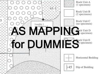
This document provides information and instructions for interpreting a geological map, including identifying rock units, folds, faults, unconformities, and relative age relationships. It discusses key, scale, trend and symmetry of folds, characteristics of different types of faults and intrusions. It provides examples of questions one might be asked to interpret features on a geological map and derive the geological history of the area.
Report
Share
Report
Share

Recommended
AS Geology mapping
This document provides guidance on mapping geological structures and features from maps. It includes explanations of key map elements like the map key, scale, and north arrow. It also defines and provides examples of important geological structures like folds, faults, intrusions, and unconformities. The document seeks to help readers interpret maps by describing these features, explaining how to identify and describe them, and posing questions about the geological history that can be answered from the map evidence.
Geologic maps show the distribution of rock units at the sur.pdf
Geologic maps show the distribution of rock units at the surface as well as structural features,
such as faults and folds. A geologic map is usually printed on top of a regular topographic map
(the base map) to help you locate yourself on the map. The base map is printed with light colors,
so it doesn't interfere with seeing the geologic features on the map. The geology is represented by
colors, lines, and symbols unique to geologic maps. Each color used on a geologic map
represents a different geologic unit. A unit is a specific type of rock of a specific age range (for
example, a Permian limestone, a contact late Triassic sandstone, etc). All exposures of rocks of
the same age and type are shown with the same color and are separated from other rocks by a
line representing the contact between them. The two main types of contacts shown on most
geologic maps are depositional contacts and faults. Where the original depositional contact
between geologic units is preserved, it is shown on the geologic map as a thin line. If the rocks are
in contact because of a fault, a thicker line is used to represent the fault, and the relative motion
along the fault, if known, is indicated by labeling the upthrown side and downthrown side of the
fault. For low angle (thrust) faults the teeth are on the upthrown (hanging wall) block. Each
geologic unit is assigned a set of letters to symbolize it on the map. Usually the symbol is the
combination of a capital letter followed by one or more small letters. The capital letter represents
the age (geologic period) of the unit. Examples include Q (Quaternary), K (Cretaceous), and C
(Cambrian). The small letters indicate either the name of the unit, if it has one, or the type of rock,
if the unit has no name. Many geologic units are named based on where their characteristics are
bestdisplayed, or where they were first studied. For example, Jm is the map symbol for the
Morrison formation, a stratigraphic unit of Jurassic age first studied near Morrison, Colorado but
exposed throughout Colorado, Wyoming, and Utah (the Morrison formation is the source of many
dinosaur fossils). Js would be unnamed shale (s for shale) that is Jurassic in age. Sedimentary
rocks form in broad, flat layers (beds) that may later be tilted or bent by tectonic forces. The spatial
orientation of tilted rock layers is described in terms of strike and dip. Strike is the compass
direction of a line formed by the intersection of a horizontal plane (the surface of the Earth) and an
inclined surface (the titled rock layer). Dip is the angle between a horizontal plane and the inclined
surface and is always measured perpendicular to strike. On geologic maps " T " shaped-symbols
are used show the strike and dip of each rock unit. The top of the "T" is the line of strike and the
short arm of the " T " illustrates the dip direction in degrees. The higher the number, the steeper
the bed with 90 being perpendicular to the surface (vertical). In the example h.
22 Where are the youngest rocks exposed in this area What .pdf
22. Where are the youngest rocks exposed in this area? What is their age (geologic period)?
23. Where are the oldest rocks exposed in this area? What is their age (geologic period)?
24. Study the pattern made by the rock units in Michigans Lower Peninsula (between Lake
Michigan and Lake Huron). What major structural feature is shown? Provide reason(s) to support
your answer.
Hint: note the spatial outcrop pattern and the age relationship between different units (as shown by
the map legend). Remember from the lecture that domes and basins are circular features, and we
tell the two apart by the age relationship of the rock units. In a dome, the oldest rocks are in
themiddle, with younger rocks around the edges. In a basin, the youngest rocks are in the middle,
while the oldest rocks are around the edges. This is where the legend that accompanies the map
comesin. The different rock units, shown in different colors, are arranged in order in the legend
from youngest at the top to oldest at the bottom. So the legend allows you to determine the
relative agesof the rock units on the map (which are older, which are younger) and hence whether
this circular feature is a dome or a basin.
25. Note the outcrop pattern of Silurian and Devonian rocks in northwest Indiana. What major
structural feature is present in this area? How can you tell?
Hint: Notice that in this area the rock units are repeated like stripes. This indicates the presence of
a fold. You would then have to look at the relative ages of the rocks, using the legend, to tell
whether the fold is an anticline or a syncline. Synclines have the youngest rocks in the middle of
the fold; anticlines have the oldest rocks in the middle of the fold.
26. What is the oldest possible age of the folding event in NW Indiana? How can you tell?
Hint: remember the principle of original horizontality: the rock units were horizontal when they
were deposited, and only folded some time after they were deposited. Hence, the fold can be no
older than the youngest rock unit involved in the fold.
27. What is the linear feature shown on the map between Lansing and Detroit?
Hint: note that this feature is shown with a thicker line than the contacts between units shown
everywhere else on the map. If you dont know the significance of a contact drawn with a thicker
line, then you need to re-read the preceding introduction to geologic maps.
Geologic maps show the distribution of rock units at the surface as well as structural features,
such as faults and folds. A geologic map is usually printed on top of a regular topographic map
(the base map) to help you locate yourself on the map. The base map is printed with light colors,
so it doesn't interfere with seeing the geologic features on the map. The geology is represented by
colors, lines, and symbols unique to geologic maps. Each color used on a geologic map
represents a different geologic unit. A unit is a specific type of rock of a specific age range (for
example, a Perm.
Structural Geology for Civil Engineering
1) Geological structures such as folds, faults, joints and unconformities form in rocks due to tectonic plate forces and deformation of the earth's crust.
2) These structures can change the physical properties of rocks, making them more or less suitable for civil engineering projects. For example, sedimentary rocks with an upstream dip are more suitable for dam sites than the same rocks with a downstream dip.
3) Folds, faults, unconformities and other structures are investigated in detail when evaluating sites for major construction due to the weaknesses and hazards they may pose.
G231 intro maps_xsections.2012
This document provides instructions for a lab assignment in a geosciences course. Students are asked to analyze and interpret several geologic maps and construct cross-sections from the maps. They are to answer 21 questions about the maps, interpreting features like rock units, structures, and stratigraphy. The lab is due at the beginning of the next class meeting on February 23, 2012 and is worth a total of 121 points.
Geological faults student copy
This document describes different types of geological faults, including dip-slip faults (normal and reverse), strike-slip faults (tear and transform), and thrust faults. It provides examples of each type and diagrams to illustrate normal faults, reverse faults, and strike-slip faults. Key points covered include the East African Rift Valley as an example of a normal fault, thrust faults being associated with mountain building, and the San Andreas Fault as an example of a transform fault.
Plate Tectonics
Here are the key points your group discussed about fault lines and earthquakes in the local area:
1. A fault line is a fracture or break in the Earth's crust along which movement has occurred.
2. Major local fault lines include the Waimea, Grampians, Flaxmore, Sharland, and 88 Faults.
3. Earthquakes are caused by movement along fault lines. When the rocks on either side of a fault slip or grind past each other, energy is released in waves that cause the shaking we feel during earthquakes.
4. Historical earthquakes in the Nelson area, such as in 1848, 1868, 1893, 1929 and 1968, were likely caused by movement along local faults
3.a. geom proses struktural
The document discusses various types of structural geology features including folds, faults, and related terminology. It provides classifications of folds based on the relative position of older and younger rock layers, their shape, the inclination of the axial plane, and the relative dip of the limbs. It also discusses fault terminology such as hanging wall, footwall, and different types of faults including normal, reverse, strike-slip, and their related landforms. Graben and horst structures are described as areas of subsidence or elevation between fault blocks.
3. geom proses struktural
The document discusses various types of structural geology features including folds, faults, and related terminology. It provides classifications of folds based on the relative position of older and younger rock layers, their shape, the inclination of the axial plane, and the relative dip of the limbs. It also discusses fault terminology such as hanging wall, footwall, and different types of faults including normal, reverse, strike-slip, and their related landforms. Graben and horst structures are described as areas of subsidence or elevation between fault blocks.
earth sci.pptx
This document contains a diagnostic test in Science with multiple choice questions about plate tectonics and plate boundaries. There are various questions testing understanding of the three main types of plate boundaries (divergent, convergent, and transform), where new oceanic lithosphere forms, areas of explosive volcanic activity, subduction zones, and features associated with different boundaries. The test aims to assess knowledge of plate tectonics concepts.
STUDENT’S NAME _________________________Multiple Choice – Hi.docx
STUDENT’S NAME: _________________________
Multiple Choice – Highlight the correct answer (2 pts. each)
1. What is the study of the layers in sedimentary rocks known as _________.
A) Stratigraphy B) paleontology C) sedimentation D) geochronology
2.
Which of the following is the best statement of the principle of original horizontality?
A)
Igneous intrusions form horizontal layers.
B)
Metamorphic isograds are horizontal before deformation.
C)
Sediments are deposited as horizontal layers.
D)
Most igneous, metamorphic, and sedimentary rocks of crust form horizontal layers.
3.
The principle of superposition states that __________.
A)
A fault is younger than the rocks it cuts
B)
Sediments are deposited as essentially horizontal layers
C)
The present is the key to the past
D)
Undisturbed sedimentary layers get progressively younger from bottom to top
4.
Which of the following is used by geologists to determine the relative ages in a rock sequence?
A) cross-cutting relations B) fossils C) stratigraphy D) all of the above
5.
The study of ancient life forms preserved in the rock record is referred to as _________.
A) Stratigraphy B) paleontology C) geochronology D) zoology
6.
The line formed by the intersection of an inclined sedimentary layer and a horizontal plane is called the ______.
7.
Geologic maps are used to depict ________.
A)
The strike and dip of the rock units at the Earth's surface
B)
The rock formations exposed on the Earth's surface
C)
The orientation of geologic structures that deform rocks exposed at the Earth's surface
D)
all of the above
8.
A diagram representing a vertical slice through the Earth's crust is called a _________.
A)
Geologic map
C)
subsurface picture
B)
Geologic model
D)
geologic cross section
DIAGRAM for Questions 9, 10, 11
Units A, B, C, D, and E are sedimentary rocks. The thick dark line is a fault.
9.
Based on DIAGRAM ABOVE: When did faulting occur?
A)
Between the deposition of A and B
C)
between the deposition of B and C
B)
Between the deposition of C and D
D)
between the deposition of D and E
10.
What is the relative timing between faulting and intrusion of the granite?
A)
Faulting occurred after the intrusion of the granite.
B)
Faulting occurred before the intrusion of the granite.
C)
Faulting and intrusion of the granite occurred at the same time.
D)
The relative timing between faulting and intrusion of the granite cannot be determined from the information provided.
11.
Which of the following units is the oldest?
A) unit A B) unit C C) unit E D) the granite
12.
The absolute age of a geologic event in the rock record is __________.
A)
The number of years that has elapsed between the event and the present day
B)
The amount of time that has elapsed between the event and the beginning of Earth history
C)
The number of years that has elapsed between the event and the beginning of human civilization
D)
The amoun.
Ieso 2012-wr-geosphere
This document contains a written test with 32 multiple choice questions about various topics in geology. The test asks questions about topics like seismic signals in the core, types of faults, isostatic models, sedimentary structures, mineral properties, plate tectonics evidence, and more. It provides multiple choice answers for each question and asks test takers to choose the single best answer and mark their responses on a separate answer sheet.
LundSnee_Miller_of2015-2_text
This document provides a summary of a preliminary geologic map of Cenozoic units in central Robinson Mountain volcanic field and northwestern Huntington Valley in Nevada. It describes the geologic setting and units mapped, including Late Cretaceous(?)-Eocene(?) conglomerate, sandstone, siltstone and limestone unit (TKcs) which forms the basal Cenozoic deposits. TKcs shows variable dip and contains clasts derived from local Paleozoic rocks, ranging from pebbles to cobbles. It forms resistant conglomerate outcrops as well as less resistant siltstone and sandstone exposures.
UNCONFORMITY BY DHARMESH
This document defines and describes different types of unconformities in geology. It begins by defining an unconformity as a break or gap in the geological record representing a period of erosion or non-deposition. It then describes the major types of unconformities, including angular, disconformity, non-conformity, and local unconformities. Finally, it outlines several ways that unconformities provide significance, such as indicating time intervals missing from the geological record, structural discordances between rock layers, evidence of past topography, and signs of weathering at the contact surface.
map is below Look at the Explanation on the right side of the map. T.pdf
map is below Look at the Explanation on the right side of the map. This key shows rock
formations, groups and the ages of rock that are exposed on the surface in the Austin area. Notw
When aska geologic time period, use the LEFT SIDE of the Explanation key for the best
answers. 1. What Cenozoic epochs are missing from this key? and Why do you think they are
missing? They were: Cretaceotus, eroded away or never deposited) (buried deep below the 2.
What geologic time period dominates the Austin area? 3. The Colorndo River running through
the Austin area begins at what lake? 4. What formation outcrops along the shores of Lake
Travis? bol, meaning Formation from what period? 5. What symbol (light orange) occurs along
the sides of Lake Austin and the Colorado River near Lake Travis? meaning the deposits from
what epoch? 6. What symbol occurs along the sides of the Colorado River near Longhorn Dam
at latitude 3015N ? meaning deposits from what epoch? 7. DU is the symbol for a The "U"
means and the 8. What age rocks occur on the upthrown side of the Mount Bonnell Fault at
latitude 3015 N? symbol, meaning period from what formation? 9. What age rocks occur on the
downthrown side of the Mount Bonnell Fault at latitude 30-15'N? symbol, meaning period from
what formation? 10. At latitude 30907/30N by longitude 973730W (look for a + sign) you are in
what symbol? meaning the group from what period? 11. At latitude 300730NN by longitude
9752330rW (look for a + sign) you are in what 5yybol ? meaning the Formation from what
period? What fossils can be found at this location? 12. Just to the west of latitude 3007/30N by
longitude 9752/30NW, you see multiple faulting in a purple and blue area that involves what two
symbols? \&c 13. Which of these symbols (from Question 12) is the oldest? It represents rocks
from the Formation which contains fossils of.
Group-4-GEOLOGY-ppt.ppt
The document provides information on measuring and analyzing geological structures like bedding, folds, faults, and joints. It discusses strike and dip, which describe the orientation of bedding planes, and how they are measured. It also covers different types of folds, faults, and joints. The document discusses the importance of strike and dip for determining relative rock ages and classifying geological structures. Finally, it discusses physical and mechanical rock properties like porosity, permeability, hardness, strength, elasticity, and plasticity as well as how elastic wave velocities relate to interpreting rock properties.
Group-5-Report-EDITED.pptx
This document discusses how geologists measure geological structures in the field. It provides details on key measurements like strike and dip, which describe the orientation of geological features. Strike is the compass orientation of a horizontal line on a tilted surface. Dip is the angle at which the surface dips from horizontal. Geologists use a Brunton compass to measure strike and dip in the field. The document also discusses outcrops, which are exposures of rock formations at the surface. Outcrop patterns provide clues about the structure, thickness, and orientation of geological layers.
Attitude of beds
1. Strike is the direction of the intersection of a geologic structure with a horizontal plane, while dip is the angle of inclination from horizontal.
2. A Brunton compass is used to measure the strike and dip of geologic structures in the field.
3. An outcrop is an exposure of a rock formation at the surface, and its pattern depends on factors like the structure's orientation and the topography.
Group-4-GEOLOGY-ppt (1).ppt
The document provides information on measuring and describing the orientation and structures of geological features. It discusses the importance of measuring the strike and dip of bedding planes, as they can indicate the geological history of folding and tilting in a region. Strike is defined as the compass orientation of a horizontal line on a bed's surface, while dip is the angle at which the bed dips from horizontal. Folds, faults, and joints are also described, along with how to measure strike and dip using a Brunton compass. Finally, characteristics such as porosity, permeability, and strength are discussed as important physical and mechanical properties of rocks.
A Question Of Glaciers
1. Red tarn is an example of a glacial erosion feature called a cirque.
2. Arrows A and B are pointing to arêtes, which are sharp ridges formed when adjoining cirques erode into one another.
3. A hanging valley provides evidence of past glaciation on this map, as the glacier eroded the landscape differently at different elevations.
Topographic Maps for Earth Science
This document provides an introduction to using topographic maps for earth science. It explains the purpose and features of topographic maps, including their symbols and scale. It describes how contour lines represent elevation and gradient. It then provides examples for students to practice reading a map, including determining elevation, gradient, distance and navigating terrain features. Exercises guide students to analyze stream gradients, slope steepness, and potential challenges driving in the area.
Unconformity vivek-131216012700-phpapp02
This document discusses unconformities, which are surfaces that separate younger rock strata from older rocks. Unconformities form due to erosion during periods of tectonic uplift or subsidence. There are several types of unconformities including angular unconformities, non-conformities, and disconformities. Unconformities are important geological features that can indicate past tectonic activity and paleogeography. They also represent gaps in the geological record where deposition did not occur.
10. fascinating fossils
The document discusses fossils and the geologic column. It begins with an introduction to fossils and their role in the debate between science and the Bible. It then discusses the geologic column, explaining that it represents the vertical order of rock layers in the Earth's crust containing different fossils. Finally, it notes that while the geologic column is generally accepted, some question whether it provides evidence for evolution versus a biblical creation model of Earth's history.
document.pdf
The document discusses the use of dipmeter logging tools to identify subsurface geological structures. It provides details on how dipmeter tools measure dip angles and directions to reveal features like faults, folds, and stratigraphic boundaries. Structural interpretation of dipmeter data involves analyzing characteristic dip patterns and comparing them to patterns associated with different structures. As an example, the document analyzes dipmeter log data from a well in India. The data is interpreted to indicate a minor normal drag fault and angular unconformity based on observed red and blue dip patterns matching expected patterns for those features. Integrating dipmeter and seismic data improves structural resolution near wells.
Geological structures folds faults joints types of folds joints
This document discusses different types of geological structures including folds, faults, and joints. It defines key terms related to these structures and provides examples. Specifically, it describes:
1) Different types of folds such as anticlines, synclines, symmetrical, asymmetrical, overturned, and recumbent folds.
2) Fault types including normal, reverse, strike-slip, oblique-slip, and blind faults. It explains the movement and features of each.
3) Joints as fractures with no displacement that form due to stresses and rock movements, and classifies them as tension or shear joints.
Plate boundaries stresses faults ppt
This document discusses plate tectonics and the three types of plate boundaries: divergent boundaries, convergent boundaries, and transform boundaries. It describes how each boundary type results in different stresses on rocks and the formation of different geological features. Divergent boundaries result in tension stresses that cause normal faults and the formation of rift valleys or sea floor spreading. Convergent boundaries result in compression stresses that cause reverse faults and the uplifting of folded mountains or subduction zones and volcanoes. Transform boundaries result in shearing stresses that cause strike-slip faults like the San Andreas Fault in California.
What’s Up A Relative Age Dating Activity By Chr.docx
What’s
Up?
A Relative Age Dating
Activity
By Christine
McLelland
Topic: Relative age dating of geologic cross sections
Content Standard: National Earth and Space Science Standard
Content Objective: This exercise will introduce your students to the concept of
relative age dating, and allow them to practice their new skills by determining the age
sequence of geologic events in a cross section. They will learn the geologic principles
that help geologists in their study of the Earth’s crust.
Materials Needed: Student pages, which contain cross sections.
Author: Written by Christine V. McLelland, Geological Society of America, 3300
Penrose Place, Boulder, CO 80301; hints adapted from Jonathan Bushee and Raman
Singh, Northern Kentucky University.
What’s Up?
A Relative Age Dating Activity
By Christine McLelland
Name:
Purpose: In this activity you will learn to determine the sequence of geologic events from cross-
sections of strata (rocks) in a given area. It is a bit of a mind-puzzler, so have fun!
Background: Before absolute dating of rocks was developed in the 20
th
century, geologists had
to rely on relative age dating, which places geologic events in their order of occurrence. The
method begins with the careful drawing and description of strata (the geologic cross section or
profile). Relative age dating assumes that the lower layers in any particular cross section are
older than the upper layers in that cross section (“the law of superposition”) and that an object
cannot be older than the materials of which it is composed. Igneous rocks are dated according to
whether they caused metamorphism in the surrounding rock (proof that they intruded into the
preexisting rock), whether they cross cut preexisting rocks, or whether sediments were deposited
on them after they were formed. The profile from one location is then compared with profiles
from surrounding sites to determine the geologic history of a larger area. If fossils are present in
the rocks, they may also be used to correlate rock layers across large distances and, now that
absolute time has been established, to determine the age of the rocks.
How? In this process, you will study the rocks and events in a geologic cross section and put
them in the correct order from oldest to youngest. In order to do your best on this activity, you
must understand a few of the basic principles that are applicable to relative age relationships
between rocks:
Principle of superposition: in a sequence of undeformed sedimentary rocks, the oldest beds are
on the bottom and the youngest are on the top.
Principle of original horizontality: sedimentary layers are horizontal, or nearly so, when
originally deposited. Strata that are not horizontal have been deformed by movements of
the Earth’s crust.
Principle of faunal succession: groups of fossil plants and animals occur in the geologic record.
Unconformities are gaps in the rock record- representing times during.pdf
Unconformities are gaps in the rock record, representing times during which either no rocks were
deposited, or existing rocks were eroded. The contact between older, eroded layers and younger,
overlying layers is often irregular, so that unconformities are usually easy to recognize. Angular
unconformities are contacts where younger rocks have been deposited horizontally on top of
older rocks that had been tilted or folded. Across the resulting contact, the beds on one side of
the angular unconformity are at an angle to the beds below it (i.e., not all the rock layers are
parallel to one another). Cross-cutting relations states that any feature which cuts across a second
feature is younger than the second feature. For example, if a fault cuts across rock layers, then
the fault is younger than the rocks. If rocks are tilted or folded, the time of deformation is
younger than the rocks. Unconformities and igneous intrusions can also cut across pre-existing
layers. Figure 1 represents a vertical cross section, i.e., what you would see in a cliff face or road
cut. The rock units and events are numbered according to stratigraphic principles. Layer \#1 is
the oldest, with \#2 - \#5 deposited successively on top of it. Then all five layers were tilted
during time \#6. Erosion followed, producing the angular unconformity \#7. Layers \#8 and \#9
were deposited above the unconformity. Finallv, the igneous dike #10 was intruded, cutting
across the older layers. Herrstrom, University of Illinois at Urbana-Champaign, 2018 Page 4 of 8
Because of the Principle of Included Fragments, we cannot use numerical dating to determine the
ages of sedimentary rocks in the geologic cross-section. However, we can bracket the ages of
these rocks using relative dating and the known ages of those rocks we can radiometrically date.
Use the following geologic time scale to answer the last three questions regarding the ages of the
sedimentary rocks in the 10. Over which geologic time periods did Beds 1 through 4 form? 11.
Over which geologic time periods did Beds 5 through 9 form? 12. Bed 10 could not be older than
the period..
一比一原版卡尔加里大学毕业证(uc毕业证)如何办理
原版一模一样【微信:741003700 】【卡尔加里大学毕业证(uc毕业证)成绩单】【微信:741003700 】学位证,留信认证(真实可查,永久存档)原件一模一样纸张工艺/offer、雅思、外壳等材料/诚信可靠,可直接看成品样本,帮您解决无法毕业带来的各种难题!外壳,原版制作,诚信可靠,可直接看成品样本。行业标杆!精益求精,诚心合作,真诚制作!多年品质 ,按需精细制作,24小时接单,全套进口原装设备。十五年致力于帮助留学生解决难题,包您满意。
本公司拥有海外各大学样板无数,能完美还原。
1:1完美还原海外各大学毕业材料上的工艺:水印,阴影底纹,钢印LOGO烫金烫银,LOGO烫金烫银复合重叠。文字图案浮雕、激光镭射、紫外荧光、温感、复印防伪等防伪工艺。材料咨询办理、认证咨询办理请加学历顾问Q/微741003700
【主营项目】
一.毕业证【q微741003700】成绩单、使馆认证、教育部认证、雅思托福成绩单、学生卡等!
二.真实使馆公证(即留学回国人员证明,不成功不收费)
三.真实教育部学历学位认证(教育部存档!教育部留服网站永久可查)
四.办理各国各大学文凭(一对一专业服务,可全程监控跟踪进度)
如果您处于以下几种情况:
◇在校期间,因各种原因未能顺利毕业……拿不到官方毕业证【q/微741003700】
◇面对父母的压力,希望尽快拿到;
◇不清楚认证流程以及材料该如何准备;
◇回国时间很长,忘记办理;
◇回国马上就要找工作,办给用人单位看;
◇企事业单位必须要求办理的
◇需要报考公务员、购买免税车、落转户口
◇申请留学生创业基金
留信网认证的作用:
1:该专业认证可证明留学生真实身份
2:同时对留学生所学专业登记给予评定
3:国家专业人才认证中心颁发入库证书
4:这个认证书并且可以归档倒地方
5:凡事获得留信网入网的信息将会逐步更新到个人身份内,将在公安局网内查询个人身份证信息后,同步读取人才网入库信息
6:个人职称评审加20分
7:个人信誉贷款加10分
8:在国家人才网主办的国家网络招聘大会中纳入资料,供国家高端企业选择人才
办理卡尔加里大学毕业证(uc毕业证)【微信:741003700 】外观非常简单,由纸质材料制成,上面印有校徽、校名、毕业生姓名、专业等信息。
办理卡尔加里大学毕业证(uc毕业证)【微信:741003700 】格式相对统一,各专业都有相应的模板。通常包括以下部分:
校徽:象征着学校的荣誉和传承。
校名:学校英文全称
授予学位:本部分将注明获得的具体学位名称。
毕业生姓名:这是最重要的信息之一,标志着该证书是由特定人员获得的。
颁发日期:这是毕业正式生效的时间,也代表着毕业生学业的结束。
其他信息:根据不同的专业和学位,可能会有一些特定的信息或章节。
办理卡尔加里大学毕业证(uc毕业证)【微信:741003700 】价值很高,需要妥善保管。一般来说,应放置在安全、干燥、防潮的地方,避免长时间暴露在阳光下。如需使用,最好使用复印件而不是原件,以免丢失。
综上所述,办理卡尔加里大学毕业证(uc毕业证)【微信:741003700 】是证明身份和学历的高价值文件。外观简单庄重,格式统一,包括重要的个人信息和发布日期。对持有人来说,妥善保管是非常重要的。
一比一原版悉尼大学毕业证如何办理
原版一模一样【微信:741003700 】【悉尼大学毕业证成绩单】【微信:741003700 】学位证,留信认证(真实可查,永久存档)原件一模一样纸张工艺/offer、雅思、外壳等材料/诚信可靠,可直接看成品样本,帮您解决无法毕业带来的各种难题!外壳,原版制作,诚信可靠,可直接看成品样本。行业标杆!精益求精,诚心合作,真诚制作!多年品质 ,按需精细制作,24小时接单,全套进口原装设备。十五年致力于帮助留学生解决难题,包您满意。
本公司拥有海外各大学样板无数,能完美还原。
1:1完美还原海外各大学毕业材料上的工艺:水印,阴影底纹,钢印LOGO烫金烫银,LOGO烫金烫银复合重叠。文字图案浮雕、激光镭射、紫外荧光、温感、复印防伪等防伪工艺。材料咨询办理、认证咨询办理请加学历顾问Q/微741003700
【主营项目】
一.毕业证【q微741003700】成绩单、使馆认证、教育部认证、雅思托福成绩单、学生卡等!
二.真实使馆公证(即留学回国人员证明,不成功不收费)
三.真实教育部学历学位认证(教育部存档!教育部留服网站永久可查)
四.办理各国各大学文凭(一对一专业服务,可全程监控跟踪进度)
如果您处于以下几种情况:
◇在校期间,因各种原因未能顺利毕业……拿不到官方毕业证【q/微741003700】
◇面对父母的压力,希望尽快拿到;
◇不清楚认证流程以及材料该如何准备;
◇回国时间很长,忘记办理;
◇回国马上就要找工作,办给用人单位看;
◇企事业单位必须要求办理的
◇需要报考公务员、购买免税车、落转户口
◇申请留学生创业基金
留信网认证的作用:
1:该专业认证可证明留学生真实身份
2:同时对留学生所学专业登记给予评定
3:国家专业人才认证中心颁发入库证书
4:这个认证书并且可以归档倒地方
5:凡事获得留信网入网的信息将会逐步更新到个人身份内,将在公安局网内查询个人身份证信息后,同步读取人才网入库信息
6:个人职称评审加20分
7:个人信誉贷款加10分
8:在国家人才网主办的国家网络招聘大会中纳入资料,供国家高端企业选择人才
办理悉尼大学毕业证【微信:741003700 】外观非常简单,由纸质材料制成,上面印有校徽、校名、毕业生姓名、专业等信息。
办理悉尼大学毕业证【微信:741003700 】格式相对统一,各专业都有相应的模板。通常包括以下部分:
校徽:象征着学校的荣誉和传承。
校名:学校英文全称
授予学位:本部分将注明获得的具体学位名称。
毕业生姓名:这是最重要的信息之一,标志着该证书是由特定人员获得的。
颁发日期:这是毕业正式生效的时间,也代表着毕业生学业的结束。
其他信息:根据不同的专业和学位,可能会有一些特定的信息或章节。
办理悉尼大学毕业证【微信:741003700 】价值很高,需要妥善保管。一般来说,应放置在安全、干燥、防潮的地方,避免长时间暴露在阳光下。如需使用,最好使用复印件而不是原件,以免丢失。
综上所述,办理悉尼大学毕业证【微信:741003700 】是证明身份和学历的高价值文件。外观简单庄重,格式统一,包括重要的个人信息和发布日期。对持有人来说,妥善保管是非常重要的。
More Related Content
Similar to asmapping-131119071624-phpapp02.ppt
3. geom proses struktural
The document discusses various types of structural geology features including folds, faults, and related terminology. It provides classifications of folds based on the relative position of older and younger rock layers, their shape, the inclination of the axial plane, and the relative dip of the limbs. It also discusses fault terminology such as hanging wall, footwall, and different types of faults including normal, reverse, strike-slip, and their related landforms. Graben and horst structures are described as areas of subsidence or elevation between fault blocks.
earth sci.pptx
This document contains a diagnostic test in Science with multiple choice questions about plate tectonics and plate boundaries. There are various questions testing understanding of the three main types of plate boundaries (divergent, convergent, and transform), where new oceanic lithosphere forms, areas of explosive volcanic activity, subduction zones, and features associated with different boundaries. The test aims to assess knowledge of plate tectonics concepts.
STUDENT’S NAME _________________________Multiple Choice – Hi.docx
STUDENT’S NAME: _________________________
Multiple Choice – Highlight the correct answer (2 pts. each)
1. What is the study of the layers in sedimentary rocks known as _________.
A) Stratigraphy B) paleontology C) sedimentation D) geochronology
2.
Which of the following is the best statement of the principle of original horizontality?
A)
Igneous intrusions form horizontal layers.
B)
Metamorphic isograds are horizontal before deformation.
C)
Sediments are deposited as horizontal layers.
D)
Most igneous, metamorphic, and sedimentary rocks of crust form horizontal layers.
3.
The principle of superposition states that __________.
A)
A fault is younger than the rocks it cuts
B)
Sediments are deposited as essentially horizontal layers
C)
The present is the key to the past
D)
Undisturbed sedimentary layers get progressively younger from bottom to top
4.
Which of the following is used by geologists to determine the relative ages in a rock sequence?
A) cross-cutting relations B) fossils C) stratigraphy D) all of the above
5.
The study of ancient life forms preserved in the rock record is referred to as _________.
A) Stratigraphy B) paleontology C) geochronology D) zoology
6.
The line formed by the intersection of an inclined sedimentary layer and a horizontal plane is called the ______.
7.
Geologic maps are used to depict ________.
A)
The strike and dip of the rock units at the Earth's surface
B)
The rock formations exposed on the Earth's surface
C)
The orientation of geologic structures that deform rocks exposed at the Earth's surface
D)
all of the above
8.
A diagram representing a vertical slice through the Earth's crust is called a _________.
A)
Geologic map
C)
subsurface picture
B)
Geologic model
D)
geologic cross section
DIAGRAM for Questions 9, 10, 11
Units A, B, C, D, and E are sedimentary rocks. The thick dark line is a fault.
9.
Based on DIAGRAM ABOVE: When did faulting occur?
A)
Between the deposition of A and B
C)
between the deposition of B and C
B)
Between the deposition of C and D
D)
between the deposition of D and E
10.
What is the relative timing between faulting and intrusion of the granite?
A)
Faulting occurred after the intrusion of the granite.
B)
Faulting occurred before the intrusion of the granite.
C)
Faulting and intrusion of the granite occurred at the same time.
D)
The relative timing between faulting and intrusion of the granite cannot be determined from the information provided.
11.
Which of the following units is the oldest?
A) unit A B) unit C C) unit E D) the granite
12.
The absolute age of a geologic event in the rock record is __________.
A)
The number of years that has elapsed between the event and the present day
B)
The amount of time that has elapsed between the event and the beginning of Earth history
C)
The number of years that has elapsed between the event and the beginning of human civilization
D)
The amoun.
Ieso 2012-wr-geosphere
This document contains a written test with 32 multiple choice questions about various topics in geology. The test asks questions about topics like seismic signals in the core, types of faults, isostatic models, sedimentary structures, mineral properties, plate tectonics evidence, and more. It provides multiple choice answers for each question and asks test takers to choose the single best answer and mark their responses on a separate answer sheet.
LundSnee_Miller_of2015-2_text
This document provides a summary of a preliminary geologic map of Cenozoic units in central Robinson Mountain volcanic field and northwestern Huntington Valley in Nevada. It describes the geologic setting and units mapped, including Late Cretaceous(?)-Eocene(?) conglomerate, sandstone, siltstone and limestone unit (TKcs) which forms the basal Cenozoic deposits. TKcs shows variable dip and contains clasts derived from local Paleozoic rocks, ranging from pebbles to cobbles. It forms resistant conglomerate outcrops as well as less resistant siltstone and sandstone exposures.
UNCONFORMITY BY DHARMESH
This document defines and describes different types of unconformities in geology. It begins by defining an unconformity as a break or gap in the geological record representing a period of erosion or non-deposition. It then describes the major types of unconformities, including angular, disconformity, non-conformity, and local unconformities. Finally, it outlines several ways that unconformities provide significance, such as indicating time intervals missing from the geological record, structural discordances between rock layers, evidence of past topography, and signs of weathering at the contact surface.
map is below Look at the Explanation on the right side of the map. T.pdf
map is below Look at the Explanation on the right side of the map. This key shows rock
formations, groups and the ages of rock that are exposed on the surface in the Austin area. Notw
When aska geologic time period, use the LEFT SIDE of the Explanation key for the best
answers. 1. What Cenozoic epochs are missing from this key? and Why do you think they are
missing? They were: Cretaceotus, eroded away or never deposited) (buried deep below the 2.
What geologic time period dominates the Austin area? 3. The Colorndo River running through
the Austin area begins at what lake? 4. What formation outcrops along the shores of Lake
Travis? bol, meaning Formation from what period? 5. What symbol (light orange) occurs along
the sides of Lake Austin and the Colorado River near Lake Travis? meaning the deposits from
what epoch? 6. What symbol occurs along the sides of the Colorado River near Longhorn Dam
at latitude 3015N ? meaning deposits from what epoch? 7. DU is the symbol for a The "U"
means and the 8. What age rocks occur on the upthrown side of the Mount Bonnell Fault at
latitude 3015 N? symbol, meaning period from what formation? 9. What age rocks occur on the
downthrown side of the Mount Bonnell Fault at latitude 30-15'N? symbol, meaning period from
what formation? 10. At latitude 30907/30N by longitude 973730W (look for a + sign) you are in
what symbol? meaning the group from what period? 11. At latitude 300730NN by longitude
9752330rW (look for a + sign) you are in what 5yybol ? meaning the Formation from what
period? What fossils can be found at this location? 12. Just to the west of latitude 3007/30N by
longitude 9752/30NW, you see multiple faulting in a purple and blue area that involves what two
symbols? \&c 13. Which of these symbols (from Question 12) is the oldest? It represents rocks
from the Formation which contains fossils of.
Group-4-GEOLOGY-ppt.ppt
The document provides information on measuring and analyzing geological structures like bedding, folds, faults, and joints. It discusses strike and dip, which describe the orientation of bedding planes, and how they are measured. It also covers different types of folds, faults, and joints. The document discusses the importance of strike and dip for determining relative rock ages and classifying geological structures. Finally, it discusses physical and mechanical rock properties like porosity, permeability, hardness, strength, elasticity, and plasticity as well as how elastic wave velocities relate to interpreting rock properties.
Group-5-Report-EDITED.pptx
This document discusses how geologists measure geological structures in the field. It provides details on key measurements like strike and dip, which describe the orientation of geological features. Strike is the compass orientation of a horizontal line on a tilted surface. Dip is the angle at which the surface dips from horizontal. Geologists use a Brunton compass to measure strike and dip in the field. The document also discusses outcrops, which are exposures of rock formations at the surface. Outcrop patterns provide clues about the structure, thickness, and orientation of geological layers.
Attitude of beds
1. Strike is the direction of the intersection of a geologic structure with a horizontal plane, while dip is the angle of inclination from horizontal.
2. A Brunton compass is used to measure the strike and dip of geologic structures in the field.
3. An outcrop is an exposure of a rock formation at the surface, and its pattern depends on factors like the structure's orientation and the topography.
Group-4-GEOLOGY-ppt (1).ppt
The document provides information on measuring and describing the orientation and structures of geological features. It discusses the importance of measuring the strike and dip of bedding planes, as they can indicate the geological history of folding and tilting in a region. Strike is defined as the compass orientation of a horizontal line on a bed's surface, while dip is the angle at which the bed dips from horizontal. Folds, faults, and joints are also described, along with how to measure strike and dip using a Brunton compass. Finally, characteristics such as porosity, permeability, and strength are discussed as important physical and mechanical properties of rocks.
A Question Of Glaciers
1. Red tarn is an example of a glacial erosion feature called a cirque.
2. Arrows A and B are pointing to arêtes, which are sharp ridges formed when adjoining cirques erode into one another.
3. A hanging valley provides evidence of past glaciation on this map, as the glacier eroded the landscape differently at different elevations.
Topographic Maps for Earth Science
This document provides an introduction to using topographic maps for earth science. It explains the purpose and features of topographic maps, including their symbols and scale. It describes how contour lines represent elevation and gradient. It then provides examples for students to practice reading a map, including determining elevation, gradient, distance and navigating terrain features. Exercises guide students to analyze stream gradients, slope steepness, and potential challenges driving in the area.
Unconformity vivek-131216012700-phpapp02
This document discusses unconformities, which are surfaces that separate younger rock strata from older rocks. Unconformities form due to erosion during periods of tectonic uplift or subsidence. There are several types of unconformities including angular unconformities, non-conformities, and disconformities. Unconformities are important geological features that can indicate past tectonic activity and paleogeography. They also represent gaps in the geological record where deposition did not occur.
10. fascinating fossils
The document discusses fossils and the geologic column. It begins with an introduction to fossils and their role in the debate between science and the Bible. It then discusses the geologic column, explaining that it represents the vertical order of rock layers in the Earth's crust containing different fossils. Finally, it notes that while the geologic column is generally accepted, some question whether it provides evidence for evolution versus a biblical creation model of Earth's history.
document.pdf
The document discusses the use of dipmeter logging tools to identify subsurface geological structures. It provides details on how dipmeter tools measure dip angles and directions to reveal features like faults, folds, and stratigraphic boundaries. Structural interpretation of dipmeter data involves analyzing characteristic dip patterns and comparing them to patterns associated with different structures. As an example, the document analyzes dipmeter log data from a well in India. The data is interpreted to indicate a minor normal drag fault and angular unconformity based on observed red and blue dip patterns matching expected patterns for those features. Integrating dipmeter and seismic data improves structural resolution near wells.
Geological structures folds faults joints types of folds joints
This document discusses different types of geological structures including folds, faults, and joints. It defines key terms related to these structures and provides examples. Specifically, it describes:
1) Different types of folds such as anticlines, synclines, symmetrical, asymmetrical, overturned, and recumbent folds.
2) Fault types including normal, reverse, strike-slip, oblique-slip, and blind faults. It explains the movement and features of each.
3) Joints as fractures with no displacement that form due to stresses and rock movements, and classifies them as tension or shear joints.
Plate boundaries stresses faults ppt
This document discusses plate tectonics and the three types of plate boundaries: divergent boundaries, convergent boundaries, and transform boundaries. It describes how each boundary type results in different stresses on rocks and the formation of different geological features. Divergent boundaries result in tension stresses that cause normal faults and the formation of rift valleys or sea floor spreading. Convergent boundaries result in compression stresses that cause reverse faults and the uplifting of folded mountains or subduction zones and volcanoes. Transform boundaries result in shearing stresses that cause strike-slip faults like the San Andreas Fault in California.
What’s Up A Relative Age Dating Activity By Chr.docx
What’s
Up?
A Relative Age Dating
Activity
By Christine
McLelland
Topic: Relative age dating of geologic cross sections
Content Standard: National Earth and Space Science Standard
Content Objective: This exercise will introduce your students to the concept of
relative age dating, and allow them to practice their new skills by determining the age
sequence of geologic events in a cross section. They will learn the geologic principles
that help geologists in their study of the Earth’s crust.
Materials Needed: Student pages, which contain cross sections.
Author: Written by Christine V. McLelland, Geological Society of America, 3300
Penrose Place, Boulder, CO 80301; hints adapted from Jonathan Bushee and Raman
Singh, Northern Kentucky University.
What’s Up?
A Relative Age Dating Activity
By Christine McLelland
Name:
Purpose: In this activity you will learn to determine the sequence of geologic events from cross-
sections of strata (rocks) in a given area. It is a bit of a mind-puzzler, so have fun!
Background: Before absolute dating of rocks was developed in the 20
th
century, geologists had
to rely on relative age dating, which places geologic events in their order of occurrence. The
method begins with the careful drawing and description of strata (the geologic cross section or
profile). Relative age dating assumes that the lower layers in any particular cross section are
older than the upper layers in that cross section (“the law of superposition”) and that an object
cannot be older than the materials of which it is composed. Igneous rocks are dated according to
whether they caused metamorphism in the surrounding rock (proof that they intruded into the
preexisting rock), whether they cross cut preexisting rocks, or whether sediments were deposited
on them after they were formed. The profile from one location is then compared with profiles
from surrounding sites to determine the geologic history of a larger area. If fossils are present in
the rocks, they may also be used to correlate rock layers across large distances and, now that
absolute time has been established, to determine the age of the rocks.
How? In this process, you will study the rocks and events in a geologic cross section and put
them in the correct order from oldest to youngest. In order to do your best on this activity, you
must understand a few of the basic principles that are applicable to relative age relationships
between rocks:
Principle of superposition: in a sequence of undeformed sedimentary rocks, the oldest beds are
on the bottom and the youngest are on the top.
Principle of original horizontality: sedimentary layers are horizontal, or nearly so, when
originally deposited. Strata that are not horizontal have been deformed by movements of
the Earth’s crust.
Principle of faunal succession: groups of fossil plants and animals occur in the geologic record.
Unconformities are gaps in the rock record- representing times during.pdf
Unconformities are gaps in the rock record, representing times during which either no rocks were
deposited, or existing rocks were eroded. The contact between older, eroded layers and younger,
overlying layers is often irregular, so that unconformities are usually easy to recognize. Angular
unconformities are contacts where younger rocks have been deposited horizontally on top of
older rocks that had been tilted or folded. Across the resulting contact, the beds on one side of
the angular unconformity are at an angle to the beds below it (i.e., not all the rock layers are
parallel to one another). Cross-cutting relations states that any feature which cuts across a second
feature is younger than the second feature. For example, if a fault cuts across rock layers, then
the fault is younger than the rocks. If rocks are tilted or folded, the time of deformation is
younger than the rocks. Unconformities and igneous intrusions can also cut across pre-existing
layers. Figure 1 represents a vertical cross section, i.e., what you would see in a cliff face or road
cut. The rock units and events are numbered according to stratigraphic principles. Layer \#1 is
the oldest, with \#2 - \#5 deposited successively on top of it. Then all five layers were tilted
during time \#6. Erosion followed, producing the angular unconformity \#7. Layers \#8 and \#9
were deposited above the unconformity. Finallv, the igneous dike #10 was intruded, cutting
across the older layers. Herrstrom, University of Illinois at Urbana-Champaign, 2018 Page 4 of 8
Because of the Principle of Included Fragments, we cannot use numerical dating to determine the
ages of sedimentary rocks in the geologic cross-section. However, we can bracket the ages of
these rocks using relative dating and the known ages of those rocks we can radiometrically date.
Use the following geologic time scale to answer the last three questions regarding the ages of the
sedimentary rocks in the 10. Over which geologic time periods did Beds 1 through 4 form? 11.
Over which geologic time periods did Beds 5 through 9 form? 12. Bed 10 could not be older than
the period..
Similar to asmapping-131119071624-phpapp02.ppt (20)
STUDENT’S NAME _________________________Multiple Choice – Hi.docx
STUDENT’S NAME _________________________Multiple Choice – Hi.docx
map is below Look at the Explanation on the right side of the map. T.pdf
map is below Look at the Explanation on the right side of the map. T.pdf
Geological structures folds faults joints types of folds joints
Geological structures folds faults joints types of folds joints
What’s Up A Relative Age Dating Activity By Chr.docx
What’s Up A Relative Age Dating Activity By Chr.docx
Unconformities are gaps in the rock record- representing times during.pdf
Unconformities are gaps in the rock record- representing times during.pdf
Recently uploaded
一比一原版卡尔加里大学毕业证(uc毕业证)如何办理
原版一模一样【微信:741003700 】【卡尔加里大学毕业证(uc毕业证)成绩单】【微信:741003700 】学位证,留信认证(真实可查,永久存档)原件一模一样纸张工艺/offer、雅思、外壳等材料/诚信可靠,可直接看成品样本,帮您解决无法毕业带来的各种难题!外壳,原版制作,诚信可靠,可直接看成品样本。行业标杆!精益求精,诚心合作,真诚制作!多年品质 ,按需精细制作,24小时接单,全套进口原装设备。十五年致力于帮助留学生解决难题,包您满意。
本公司拥有海外各大学样板无数,能完美还原。
1:1完美还原海外各大学毕业材料上的工艺:水印,阴影底纹,钢印LOGO烫金烫银,LOGO烫金烫银复合重叠。文字图案浮雕、激光镭射、紫外荧光、温感、复印防伪等防伪工艺。材料咨询办理、认证咨询办理请加学历顾问Q/微741003700
【主营项目】
一.毕业证【q微741003700】成绩单、使馆认证、教育部认证、雅思托福成绩单、学生卡等!
二.真实使馆公证(即留学回国人员证明,不成功不收费)
三.真实教育部学历学位认证(教育部存档!教育部留服网站永久可查)
四.办理各国各大学文凭(一对一专业服务,可全程监控跟踪进度)
如果您处于以下几种情况:
◇在校期间,因各种原因未能顺利毕业……拿不到官方毕业证【q/微741003700】
◇面对父母的压力,希望尽快拿到;
◇不清楚认证流程以及材料该如何准备;
◇回国时间很长,忘记办理;
◇回国马上就要找工作,办给用人单位看;
◇企事业单位必须要求办理的
◇需要报考公务员、购买免税车、落转户口
◇申请留学生创业基金
留信网认证的作用:
1:该专业认证可证明留学生真实身份
2:同时对留学生所学专业登记给予评定
3:国家专业人才认证中心颁发入库证书
4:这个认证书并且可以归档倒地方
5:凡事获得留信网入网的信息将会逐步更新到个人身份内,将在公安局网内查询个人身份证信息后,同步读取人才网入库信息
6:个人职称评审加20分
7:个人信誉贷款加10分
8:在国家人才网主办的国家网络招聘大会中纳入资料,供国家高端企业选择人才
办理卡尔加里大学毕业证(uc毕业证)【微信:741003700 】外观非常简单,由纸质材料制成,上面印有校徽、校名、毕业生姓名、专业等信息。
办理卡尔加里大学毕业证(uc毕业证)【微信:741003700 】格式相对统一,各专业都有相应的模板。通常包括以下部分:
校徽:象征着学校的荣誉和传承。
校名:学校英文全称
授予学位:本部分将注明获得的具体学位名称。
毕业生姓名:这是最重要的信息之一,标志着该证书是由特定人员获得的。
颁发日期:这是毕业正式生效的时间,也代表着毕业生学业的结束。
其他信息:根据不同的专业和学位,可能会有一些特定的信息或章节。
办理卡尔加里大学毕业证(uc毕业证)【微信:741003700 】价值很高,需要妥善保管。一般来说,应放置在安全、干燥、防潮的地方,避免长时间暴露在阳光下。如需使用,最好使用复印件而不是原件,以免丢失。
综上所述,办理卡尔加里大学毕业证(uc毕业证)【微信:741003700 】是证明身份和学历的高价值文件。外观简单庄重,格式统一,包括重要的个人信息和发布日期。对持有人来说,妥善保管是非常重要的。
一比一原版悉尼大学毕业证如何办理
原版一模一样【微信:741003700 】【悉尼大学毕业证成绩单】【微信:741003700 】学位证,留信认证(真实可查,永久存档)原件一模一样纸张工艺/offer、雅思、外壳等材料/诚信可靠,可直接看成品样本,帮您解决无法毕业带来的各种难题!外壳,原版制作,诚信可靠,可直接看成品样本。行业标杆!精益求精,诚心合作,真诚制作!多年品质 ,按需精细制作,24小时接单,全套进口原装设备。十五年致力于帮助留学生解决难题,包您满意。
本公司拥有海外各大学样板无数,能完美还原。
1:1完美还原海外各大学毕业材料上的工艺:水印,阴影底纹,钢印LOGO烫金烫银,LOGO烫金烫银复合重叠。文字图案浮雕、激光镭射、紫外荧光、温感、复印防伪等防伪工艺。材料咨询办理、认证咨询办理请加学历顾问Q/微741003700
【主营项目】
一.毕业证【q微741003700】成绩单、使馆认证、教育部认证、雅思托福成绩单、学生卡等!
二.真实使馆公证(即留学回国人员证明,不成功不收费)
三.真实教育部学历学位认证(教育部存档!教育部留服网站永久可查)
四.办理各国各大学文凭(一对一专业服务,可全程监控跟踪进度)
如果您处于以下几种情况:
◇在校期间,因各种原因未能顺利毕业……拿不到官方毕业证【q/微741003700】
◇面对父母的压力,希望尽快拿到;
◇不清楚认证流程以及材料该如何准备;
◇回国时间很长,忘记办理;
◇回国马上就要找工作,办给用人单位看;
◇企事业单位必须要求办理的
◇需要报考公务员、购买免税车、落转户口
◇申请留学生创业基金
留信网认证的作用:
1:该专业认证可证明留学生真实身份
2:同时对留学生所学专业登记给予评定
3:国家专业人才认证中心颁发入库证书
4:这个认证书并且可以归档倒地方
5:凡事获得留信网入网的信息将会逐步更新到个人身份内,将在公安局网内查询个人身份证信息后,同步读取人才网入库信息
6:个人职称评审加20分
7:个人信誉贷款加10分
8:在国家人才网主办的国家网络招聘大会中纳入资料,供国家高端企业选择人才
办理悉尼大学毕业证【微信:741003700 】外观非常简单,由纸质材料制成,上面印有校徽、校名、毕业生姓名、专业等信息。
办理悉尼大学毕业证【微信:741003700 】格式相对统一,各专业都有相应的模板。通常包括以下部分:
校徽:象征着学校的荣誉和传承。
校名:学校英文全称
授予学位:本部分将注明获得的具体学位名称。
毕业生姓名:这是最重要的信息之一,标志着该证书是由特定人员获得的。
颁发日期:这是毕业正式生效的时间,也代表着毕业生学业的结束。
其他信息:根据不同的专业和学位,可能会有一些特定的信息或章节。
办理悉尼大学毕业证【微信:741003700 】价值很高,需要妥善保管。一般来说,应放置在安全、干燥、防潮的地方,避免长时间暴露在阳光下。如需使用,最好使用复印件而不是原件,以免丢失。
综上所述,办理悉尼大学毕业证【微信:741003700 】是证明身份和学历的高价值文件。外观简单庄重,格式统一,包括重要的个人信息和发布日期。对持有人来说,妥善保管是非常重要的。
Cell The Unit of Life for NEET Multiple Choice Questions.docx
celltheunitoflife
ribosomes
thegolgi
nuclearmembrane
cilia
phragmoplast
一比一原版(uom毕业证书)曼彻斯特大学毕业证如何办理
原版一模一样【微信:741003700 】【(uom毕业证书)曼彻斯特大学毕业证成绩单】【微信:741003700 】学位证,留信认证(真实可查,永久存档)原件一模一样纸张工艺/offer、雅思、外壳等材料/诚信可靠,可直接看成品样本,帮您解决无法毕业带来的各种难题!外壳,原版制作,诚信可靠,可直接看成品样本。行业标杆!精益求精,诚心合作,真诚制作!多年品质 ,按需精细制作,24小时接单,全套进口原装设备。十五年致力于帮助留学生解决难题,包您满意。
本公司拥有海外各大学样板无数,能完美还原。
1:1完美还原海外各大学毕业材料上的工艺:水印,阴影底纹,钢印LOGO烫金烫银,LOGO烫金烫银复合重叠。文字图案浮雕、激光镭射、紫外荧光、温感、复印防伪等防伪工艺。材料咨询办理、认证咨询办理请加学历顾问Q/微741003700
【主营项目】
一.毕业证【q微741003700】成绩单、使馆认证、教育部认证、雅思托福成绩单、学生卡等!
二.真实使馆公证(即留学回国人员证明,不成功不收费)
三.真实教育部学历学位认证(教育部存档!教育部留服网站永久可查)
四.办理各国各大学文凭(一对一专业服务,可全程监控跟踪进度)
如果您处于以下几种情况:
◇在校期间,因各种原因未能顺利毕业……拿不到官方毕业证【q/微741003700】
◇面对父母的压力,希望尽快拿到;
◇不清楚认证流程以及材料该如何准备;
◇回国时间很长,忘记办理;
◇回国马上就要找工作,办给用人单位看;
◇企事业单位必须要求办理的
◇需要报考公务员、购买免税车、落转户口
◇申请留学生创业基金
留信网认证的作用:
1:该专业认证可证明留学生真实身份
2:同时对留学生所学专业登记给予评定
3:国家专业人才认证中心颁发入库证书
4:这个认证书并且可以归档倒地方
5:凡事获得留信网入网的信息将会逐步更新到个人身份内,将在公安局网内查询个人身份证信息后,同步读取人才网入库信息
6:个人职称评审加20分
7:个人信誉贷款加10分
8:在国家人才网主办的国家网络招聘大会中纳入资料,供国家高端企业选择人才
办理(uom毕业证书)曼彻斯特大学毕业证【微信:741003700 】外观非常简单,由纸质材料制成,上面印有校徽、校名、毕业生姓名、专业等信息。
办理(uom毕业证书)曼彻斯特大学毕业证【微信:741003700 】格式相对统一,各专业都有相应的模板。通常包括以下部分:
校徽:象征着学校的荣誉和传承。
校名:学校英文全称
授予学位:本部分将注明获得的具体学位名称。
毕业生姓名:这是最重要的信息之一,标志着该证书是由特定人员获得的。
颁发日期:这是毕业正式生效的时间,也代表着毕业生学业的结束。
其他信息:根据不同的专业和学位,可能会有一些特定的信息或章节。
办理(uom毕业证书)曼彻斯特大学毕业证【微信:741003700 】价值很高,需要妥善保管。一般来说,应放置在安全、干燥、防潮的地方,避免长时间暴露在阳光下。如需使用,最好使用复印件而不是原件,以免丢失。
综上所述,办理(uom毕业证书)曼彻斯特大学毕业证【微信:741003700 】是证明身份和学历的高价值文件。外观简单庄重,格式统一,包括重要的个人信息和发布日期。对持有人来说,妥善保管是非常重要的。
一比一原版莱斯大学毕业证(rice毕业证)如何办理
原版一模一样【微信:741003700 】【莱斯大学毕业证(rice毕业证)成绩单】【微信:741003700 】学位证,留信认证(真实可查,永久存档)原件一模一样纸张工艺/offer、雅思、外壳等材料/诚信可靠,可直接看成品样本,帮您解决无法毕业带来的各种难题!外壳,原版制作,诚信可靠,可直接看成品样本。行业标杆!精益求精,诚心合作,真诚制作!多年品质 ,按需精细制作,24小时接单,全套进口原装设备。十五年致力于帮助留学生解决难题,包您满意。
本公司拥有海外各大学样板无数,能完美还原。
1:1完美还原海外各大学毕业材料上的工艺:水印,阴影底纹,钢印LOGO烫金烫银,LOGO烫金烫银复合重叠。文字图案浮雕、激光镭射、紫外荧光、温感、复印防伪等防伪工艺。材料咨询办理、认证咨询办理请加学历顾问Q/微741003700
【主营项目】
一.毕业证【q微741003700】成绩单、使馆认证、教育部认证、雅思托福成绩单、学生卡等!
二.真实使馆公证(即留学回国人员证明,不成功不收费)
三.真实教育部学历学位认证(教育部存档!教育部留服网站永久可查)
四.办理各国各大学文凭(一对一专业服务,可全程监控跟踪进度)
如果您处于以下几种情况:
◇在校期间,因各种原因未能顺利毕业……拿不到官方毕业证【q/微741003700】
◇面对父母的压力,希望尽快拿到;
◇不清楚认证流程以及材料该如何准备;
◇回国时间很长,忘记办理;
◇回国马上就要找工作,办给用人单位看;
◇企事业单位必须要求办理的
◇需要报考公务员、购买免税车、落转户口
◇申请留学生创业基金
留信网认证的作用:
1:该专业认证可证明留学生真实身份
2:同时对留学生所学专业登记给予评定
3:国家专业人才认证中心颁发入库证书
4:这个认证书并且可以归档倒地方
5:凡事获得留信网入网的信息将会逐步更新到个人身份内,将在公安局网内查询个人身份证信息后,同步读取人才网入库信息
6:个人职称评审加20分
7:个人信誉贷款加10分
8:在国家人才网主办的国家网络招聘大会中纳入资料,供国家高端企业选择人才
办理莱斯大学毕业证(rice毕业证)【微信:741003700 】外观非常简单,由纸质材料制成,上面印有校徽、校名、毕业生姓名、专业等信息。
办理莱斯大学毕业证(rice毕业证)【微信:741003700 】格式相对统一,各专业都有相应的模板。通常包括以下部分:
校徽:象征着学校的荣誉和传承。
校名:学校英文全称
授予学位:本部分将注明获得的具体学位名称。
毕业生姓名:这是最重要的信息之一,标志着该证书是由特定人员获得的。
颁发日期:这是毕业正式生效的时间,也代表着毕业生学业的结束。
其他信息:根据不同的专业和学位,可能会有一些特定的信息或章节。
办理莱斯大学毕业证(rice毕业证)【微信:741003700 】价值很高,需要妥善保管。一般来说,应放置在安全、干燥、防潮的地方,避免长时间暴露在阳光下。如需使用,最好使用复印件而不是原件,以免丢失。
综上所述,办理莱斯大学毕业证(rice毕业证)【微信:741003700 】是证明身份和学历的高价值文件。外观简单庄重,格式统一,包括重要的个人信息和发布日期。对持有人来说,妥善保管是非常重要的。
06-12-2024-BudapestDataForum-BuildingReal-timePipelineswithFLaNK AIM
06-12-2024-BudapestDataForum-BuildingReal-timePipelineswithFLaNK AIM
by
Timothy Spann
Principal Developer Advocate
https://budapestdata.hu/2024/en/
https://budapestml.hu/2024/en/
tim.spann@zilliz.com
https://www.linkedin.com/in/timothyspann/
https://x.com/paasdev
https://github.com/tspannhw
https://www.youtube.com/@flank-stack
milvus
vector database
gen ai
generative ai
deep learning
machine learning
apache nifi
apache pulsar
apache kafka
apache flink
一比一原版加拿大渥太华大学毕业证(uottawa毕业证书)如何办理
原版一模一样【微信:741003700 】【渥太华大学毕业证(uottawa毕业证书)成绩单】【微信:741003700 】学位证,留信认证(真实可查,永久存档)原件一模一样纸张工艺/offer、雅思、外壳等材料/诚信可靠,可直接看成品样本,帮您解决无法毕业带来的各种难题!外壳,原版制作,诚信可靠,可直接看成品样本。行业标杆!精益求精,诚心合作,真诚制作!多年品质 ,按需精细制作,24小时接单,全套进口原装设备。十五年致力于帮助留学生解决难题,包您满意。
本公司拥有海外各大学样板无数,能完美还原。
1:1完美还原海外各大学毕业材料上的工艺:水印,阴影底纹,钢印LOGO烫金烫银,LOGO烫金烫银复合重叠。文字图案浮雕、激光镭射、紫外荧光、温感、复印防伪等防伪工艺。材料咨询办理、认证咨询办理请加学历顾问Q/微741003700
【主营项目】
一.毕业证【q微741003700】成绩单、使馆认证、教育部认证、雅思托福成绩单、学生卡等!
二.真实使馆公证(即留学回国人员证明,不成功不收费)
三.真实教育部学历学位认证(教育部存档!教育部留服网站永久可查)
四.办理各国各大学文凭(一对一专业服务,可全程监控跟踪进度)
如果您处于以下几种情况:
◇在校期间,因各种原因未能顺利毕业……拿不到官方毕业证【q/微741003700】
◇面对父母的压力,希望尽快拿到;
◇不清楚认证流程以及材料该如何准备;
◇回国时间很长,忘记办理;
◇回国马上就要找工作,办给用人单位看;
◇企事业单位必须要求办理的
◇需要报考公务员、购买免税车、落转户口
◇申请留学生创业基金
留信网认证的作用:
1:该专业认证可证明留学生真实身份
2:同时对留学生所学专业登记给予评定
3:国家专业人才认证中心颁发入库证书
4:这个认证书并且可以归档倒地方
5:凡事获得留信网入网的信息将会逐步更新到个人身份内,将在公安局网内查询个人身份证信息后,同步读取人才网入库信息
6:个人职称评审加20分
7:个人信誉贷款加10分
8:在国家人才网主办的国家网络招聘大会中纳入资料,供国家高端企业选择人才
办理渥太华大学毕业证(uottawa毕业证书)【微信:741003700 】外观非常简单,由纸质材料制成,上面印有校徽、校名、毕业生姓名、专业等信息。
办理渥太华大学毕业证(uottawa毕业证书)【微信:741003700 】格式相对统一,各专业都有相应的模板。通常包括以下部分:
校徽:象征着学校的荣誉和传承。
校名:学校英文全称
授予学位:本部分将注明获得的具体学位名称。
毕业生姓名:这是最重要的信息之一,标志着该证书是由特定人员获得的。
颁发日期:这是毕业正式生效的时间,也代表着毕业生学业的结束。
其他信息:根据不同的专业和学位,可能会有一些特定的信息或章节。
办理渥太华大学毕业证(uottawa毕业证书)【微信:741003700 】价值很高,需要妥善保管。一般来说,应放置在安全、干燥、防潮的地方,避免长时间暴露在阳光下。如需使用,最好使用复印件而不是原件,以免丢失。
综上所述,办理渥太华大学毕业证(uottawa毕业证书)【微信:741003700 】是证明身份和学历的高价值文件。外观简单庄重,格式统一,包括重要的个人信息和发布日期。对持有人来说,妥善保管是非常重要的。
一比一原版斯威本理工大学毕业证(swinburne毕业证)如何办理
原版一模一样【微信:741003700 】【斯威本理工大学毕业证(swinburne毕业证)成绩单】【微信:741003700 】学位证,留信认证(真实可查,永久存档)原件一模一样纸张工艺/offer、雅思、外壳等材料/诚信可靠,可直接看成品样本,帮您解决无法毕业带来的各种难题!外壳,原版制作,诚信可靠,可直接看成品样本。行业标杆!精益求精,诚心合作,真诚制作!多年品质 ,按需精细制作,24小时接单,全套进口原装设备。十五年致力于帮助留学生解决难题,包您满意。
本公司拥有海外各大学样板无数,能完美还原。
1:1完美还原海外各大学毕业材料上的工艺:水印,阴影底纹,钢印LOGO烫金烫银,LOGO烫金烫银复合重叠。文字图案浮雕、激光镭射、紫外荧光、温感、复印防伪等防伪工艺。材料咨询办理、认证咨询办理请加学历顾问Q/微741003700
【主营项目】
一.毕业证【q微741003700】成绩单、使馆认证、教育部认证、雅思托福成绩单、学生卡等!
二.真实使馆公证(即留学回国人员证明,不成功不收费)
三.真实教育部学历学位认证(教育部存档!教育部留服网站永久可查)
四.办理各国各大学文凭(一对一专业服务,可全程监控跟踪进度)
如果您处于以下几种情况:
◇在校期间,因各种原因未能顺利毕业……拿不到官方毕业证【q/微741003700】
◇面对父母的压力,希望尽快拿到;
◇不清楚认证流程以及材料该如何准备;
◇回国时间很长,忘记办理;
◇回国马上就要找工作,办给用人单位看;
◇企事业单位必须要求办理的
◇需要报考公务员、购买免税车、落转户口
◇申请留学生创业基金
留信网认证的作用:
1:该专业认证可证明留学生真实身份
2:同时对留学生所学专业登记给予评定
3:国家专业人才认证中心颁发入库证书
4:这个认证书并且可以归档倒地方
5:凡事获得留信网入网的信息将会逐步更新到个人身份内,将在公安局网内查询个人身份证信息后,同步读取人才网入库信息
6:个人职称评审加20分
7:个人信誉贷款加10分
8:在国家人才网主办的国家网络招聘大会中纳入资料,供国家高端企业选择人才
办理斯威本理工大学毕业证(swinburne毕业证)【微信:741003700 】外观非常简单,由纸质材料制成,上面印有校徽、校名、毕业生姓名、专业等信息。
办理斯威本理工大学毕业证(swinburne毕业证)【微信:741003700 】格式相对统一,各专业都有相应的模板。通常包括以下部分:
校徽:象征着学校的荣誉和传承。
校名:学校英文全称
授予学位:本部分将注明获得的具体学位名称。
毕业生姓名:这是最重要的信息之一,标志着该证书是由特定人员获得的。
颁发日期:这是毕业正式生效的时间,也代表着毕业生学业的结束。
其他信息:根据不同的专业和学位,可能会有一些特定的信息或章节。
办理斯威本理工大学毕业证(swinburne毕业证)【微信:741003700 】价值很高,需要妥善保管。一般来说,应放置在安全、干燥、防潮的地方,避免长时间暴露在阳光下。如需使用,最好使用复印件而不是原件,以免丢失。
综上所述,办理斯威本理工大学毕业证(swinburne毕业证)【微信:741003700 】是证明身份和学历的高价值文件。外观简单庄重,格式统一,包括重要的个人信息和发布日期。对持有人来说,妥善保管是非常重要的。
一比一原版(曼大毕业证书)曼尼托巴大学毕业证如何办理
原版一模一样【微信:741003700 】【(曼大毕业证书)曼尼托巴大学毕业证成绩单】【微信:741003700 】学位证,留信认证(真实可查,永久存档)原件一模一样纸张工艺/offer、雅思、外壳等材料/诚信可靠,可直接看成品样本,帮您解决无法毕业带来的各种难题!外壳,原版制作,诚信可靠,可直接看成品样本。行业标杆!精益求精,诚心合作,真诚制作!多年品质 ,按需精细制作,24小时接单,全套进口原装设备。十五年致力于帮助留学生解决难题,包您满意。
本公司拥有海外各大学样板无数,能完美还原。
1:1完美还原海外各大学毕业材料上的工艺:水印,阴影底纹,钢印LOGO烫金烫银,LOGO烫金烫银复合重叠。文字图案浮雕、激光镭射、紫外荧光、温感、复印防伪等防伪工艺。材料咨询办理、认证咨询办理请加学历顾问Q/微741003700
【主营项目】
一.毕业证【q微741003700】成绩单、使馆认证、教育部认证、雅思托福成绩单、学生卡等!
二.真实使馆公证(即留学回国人员证明,不成功不收费)
三.真实教育部学历学位认证(教育部存档!教育部留服网站永久可查)
四.办理各国各大学文凭(一对一专业服务,可全程监控跟踪进度)
如果您处于以下几种情况:
◇在校期间,因各种原因未能顺利毕业……拿不到官方毕业证【q/微741003700】
◇面对父母的压力,希望尽快拿到;
◇不清楚认证流程以及材料该如何准备;
◇回国时间很长,忘记办理;
◇回国马上就要找工作,办给用人单位看;
◇企事业单位必须要求办理的
◇需要报考公务员、购买免税车、落转户口
◇申请留学生创业基金
留信网认证的作用:
1:该专业认证可证明留学生真实身份
2:同时对留学生所学专业登记给予评定
3:国家专业人才认证中心颁发入库证书
4:这个认证书并且可以归档倒地方
5:凡事获得留信网入网的信息将会逐步更新到个人身份内,将在公安局网内查询个人身份证信息后,同步读取人才网入库信息
6:个人职称评审加20分
7:个人信誉贷款加10分
8:在国家人才网主办的国家网络招聘大会中纳入资料,供国家高端企业选择人才
办理(曼大毕业证书)曼尼托巴大学毕业证【微信:741003700 】外观非常简单,由纸质材料制成,上面印有校徽、校名、毕业生姓名、专业等信息。
办理(曼大毕业证书)曼尼托巴大学毕业证【微信:741003700 】格式相对统一,各专业都有相应的模板。通常包括以下部分:
校徽:象征着学校的荣誉和传承。
校名:学校英文全称
授予学位:本部分将注明获得的具体学位名称。
毕业生姓名:这是最重要的信息之一,标志着该证书是由特定人员获得的。
颁发日期:这是毕业正式生效的时间,也代表着毕业生学业的结束。
其他信息:根据不同的专业和学位,可能会有一些特定的信息或章节。
办理(曼大毕业证书)曼尼托巴大学毕业证【微信:741003700 】价值很高,需要妥善保管。一般来说,应放置在安全、干燥、防潮的地方,避免长时间暴露在阳光下。如需使用,最好使用复印件而不是原件,以免丢失。
综上所述,办理(曼大毕业证书)曼尼托巴大学毕业证【微信:741003700 】是证明身份和学历的高价值文件。外观简单庄重,格式统一,包括重要的个人信息和发布日期。对持有人来说,妥善保管是非常重要的。
一比一原版南十字星大学毕业证(SCU毕业证书)学历如何办理
原版办理【微信号:BYZS866】【南十字星大学毕业证(SCU毕业证书)】【微信号:BYZS866】《成绩单、外壳、雅思、offer、真实留信官方学历认证(永久存档/真实可查)》采用学校原版纸张、特殊工艺完全按照原版一比一制作(包括:隐形水印,阴影底纹,钢印LOGO烫金烫银,LOGO烫金烫银复合重叠,文字图案浮雕,激光镭射,紫外荧光,温感,复印防伪)行业标杆!精益求精,诚心合作,真诚制作!多年品质 ,按需精细制作,24小时接单,全套进口原装设备,十五年致力于帮助留学生解决难题,业务范围有加拿大、英国、澳洲、韩国、美国、新加坡,新西兰等学历材料,包您满意。
【我们承诺采用的是学校原版纸张(纸质、底色、纹路)我们拥有全套进口原装设备,特殊工艺都是采用不同机器制作,仿真度基本可以达到100%,所有工艺效果都可提前给客户展示,不满意可以根据客户要求进行调整,直到满意为止!】
【业务选择办理准则】
一、工作未确定,回国需先给父母、亲戚朋友看下文凭的情况,办理一份就读学校的毕业证【微信号BYZS866】文凭即可
二、回国进私企、外企、自己做生意的情况,这些单位是不查询毕业证真伪的,而且国内没有渠道去查询国外文凭的真假,也不需要提供真实教育部认证。鉴于此,办理一份毕业证【微信号BYZS866】即可
三、进国企,银行,事业单位,考公务员等等,这些单位是必需要提供真实教育部认证的,办理教育部认证所需资料众多且烦琐,所有材料您都必须提供原件,我们凭借丰富的经验,快捷的绿色通道帮您快速整合材料,让您少走弯路。
留信网认证的作用:
1:该专业认证可证明留学生真实身份
2:同时对留学生所学专业登记给予评定
3:国家专业人才认证中心颁发入库证书
4:这个认证书并且可以归档倒地方
5:凡事获得留信网入网的信息将会逐步更新到个人身份内,将在公安局网内查询个人身份证信息后,同步读取人才网入库信息
6:个人职称评审加20分
7:个人信誉贷款加10分
8:在国家人才网主办的国家网络招聘大会中纳入资料,供国家高端企业选择人才
留信网服务项目:
1、留学生专业人才库服务(留信分析)
2、国(境)学习人员提供就业推荐信服务
3、留学人员区块链存储服务
【关于价格问题(保证一手价格)】
我们所定的价格是非常合理的,而且我们现在做得单子大多数都是代理和回头客户介绍的所以一般现在有新的单子 我给客户的都是第一手的代理价格,因为我想坦诚对待大家 不想跟大家在价格方面浪费时间
对于老客户或者被老客户介绍过来的朋友,我们都会适当给一些优惠。
选择实体注册公司办理,更放心,更安全!我们的承诺:客户在留信官方认证查询网站查询到认证通过结果后付款,不成功不收费!
一比一原版英属哥伦比亚大学毕业证(UBC毕业证书)学历如何办理
原版办【微信号:BYZS866】【英属哥伦比亚大学毕业证(UBC毕业证书)】【微信号:BYZS866】《成绩单、外壳、雅思、offer、真实留信官方学历认证(永久存档/真实可查)》采用学校原版纸张、特殊工艺完全按照原版一比一制作(包括:隐形水印,阴影底纹,钢印LOGO烫金烫银,LOGO烫金烫银复合重叠,文字图案浮雕,激光镭射,紫外荧光,温感,复印防伪)行业标杆!精益求精,诚心合作,真诚制作!多年品质 ,按需精细制作,24小时接单,全套进口原装设备,十五年致力于帮助留学生解决难题,业务范围有加拿大、英国、澳洲、韩国、美国、新加坡,新西兰等学历材料,包您满意。
【我们承诺采用的是学校原版纸张(纸质、底色、纹路)我们拥有全套进口原装设备,特殊工艺都是采用不同机器制作,仿真度基本可以达到100%,所有工艺效果都可提前给客户展示,不满意可以根据客户要求进行调整,直到满意为止!】
【业务选择办理准则】
一、工作未确定,回国需先给父母、亲戚朋友看下文凭的情况,办理一份就读学校的毕业证【微信号BYZS866】文凭即可
二、回国进私企、外企、自己做生意的情况,这些单位是不查询毕业证真伪的,而且国内没有渠道去查询国外文凭的真假,也不需要提供真实教育部认证。鉴于此,办理一份毕业证【微信号BYZS866】即可
三、进国企,银行,事业单位,考公务员等等,这些单位是必需要提供真实教育部认证的,办理教育部认证所需资料众多且烦琐,所有材料您都必须提供原件,我们凭借丰富的经验,快捷的绿色通道帮您快速整合材料,让您少走弯路。
留信网认证的作用:
1:该专业认证可证明留学生真实身份
2:同时对留学生所学专业登记给予评定
3:国家专业人才认证中心颁发入库证书
4:这个认证书并且可以归档倒地方
5:凡事获得留信网入网的信息将会逐步更新到个人身份内,将在公安局网内查询个人身份证信息后,同步读取人才网入库信息
6:个人职称评审加20分
7:个人信誉贷款加10分
8:在国家人才网主办的国家网络招聘大会中纳入资料,供国家高端企业选择人才
留信网服务项目:
1、留学生专业人才库服务(留信分析)
2、国(境)学习人员提供就业推荐信服务
3、留学人员区块链存储服务
【关于价格问题(保证一手价格)】
我们所定的价格是非常合理的,而且我们现在做得单子大多数都是代理和回头客户介绍的所以一般现在有新的单子 我给客户的都是第一手的代理价格,因为我想坦诚对待大家 不想跟大家在价格方面浪费时间
对于老客户或者被老客户介绍过来的朋友,我们都会适当给一些优惠。
选择实体注册公司办理,更放心,更安全!我们的承诺:客户在留信官方认证查询网站查询到认证通过结果后付款,不成功不收费!
一比一原版南昆士兰大学毕业证如何办理
原版一模一样【微信:741003700 】【南昆士兰大学毕业证成绩单】【微信:741003700 】学位证,留信认证(真实可查,永久存档)原件一模一样纸张工艺/offer、雅思、外壳等材料/诚信可靠,可直接看成品样本,帮您解决无法毕业带来的各种难题!外壳,原版制作,诚信可靠,可直接看成品样本。行业标杆!精益求精,诚心合作,真诚制作!多年品质 ,按需精细制作,24小时接单,全套进口原装设备。十五年致力于帮助留学生解决难题,包您满意。
本公司拥有海外各大学样板无数,能完美还原。
1:1完美还原海外各大学毕业材料上的工艺:水印,阴影底纹,钢印LOGO烫金烫银,LOGO烫金烫银复合重叠。文字图案浮雕、激光镭射、紫外荧光、温感、复印防伪等防伪工艺。材料咨询办理、认证咨询办理请加学历顾问Q/微741003700
【主营项目】
一.毕业证【q微741003700】成绩单、使馆认证、教育部认证、雅思托福成绩单、学生卡等!
二.真实使馆公证(即留学回国人员证明,不成功不收费)
三.真实教育部学历学位认证(教育部存档!教育部留服网站永久可查)
四.办理各国各大学文凭(一对一专业服务,可全程监控跟踪进度)
如果您处于以下几种情况:
◇在校期间,因各种原因未能顺利毕业……拿不到官方毕业证【q/微741003700】
◇面对父母的压力,希望尽快拿到;
◇不清楚认证流程以及材料该如何准备;
◇回国时间很长,忘记办理;
◇回国马上就要找工作,办给用人单位看;
◇企事业单位必须要求办理的
◇需要报考公务员、购买免税车、落转户口
◇申请留学生创业基金
留信网认证的作用:
1:该专业认证可证明留学生真实身份
2:同时对留学生所学专业登记给予评定
3:国家专业人才认证中心颁发入库证书
4:这个认证书并且可以归档倒地方
5:凡事获得留信网入网的信息将会逐步更新到个人身份内,将在公安局网内查询个人身份证信息后,同步读取人才网入库信息
6:个人职称评审加20分
7:个人信誉贷款加10分
8:在国家人才网主办的国家网络招聘大会中纳入资料,供国家高端企业选择人才
办理南昆士兰大学毕业证【微信:741003700 】外观非常简单,由纸质材料制成,上面印有校徽、校名、毕业生姓名、专业等信息。
办理南昆士兰大学毕业证【微信:741003700 】格式相对统一,各专业都有相应的模板。通常包括以下部分:
校徽:象征着学校的荣誉和传承。
校名:学校英文全称
授予学位:本部分将注明获得的具体学位名称。
毕业生姓名:这是最重要的信息之一,标志着该证书是由特定人员获得的。
颁发日期:这是毕业正式生效的时间,也代表着毕业生学业的结束。
其他信息:根据不同的专业和学位,可能会有一些特定的信息或章节。
办理南昆士兰大学毕业证【微信:741003700 】价值很高,需要妥善保管。一般来说,应放置在安全、干燥、防潮的地方,避免长时间暴露在阳光下。如需使用,最好使用复印件而不是原件,以免丢失。
综上所述,办理南昆士兰大学毕业证【微信:741003700 】是证明身份和学历的高价值文件。外观简单庄重,格式统一,包括重要的个人信息和发布日期。对持有人来说,妥善保管是非常重要的。
一比一原版加拿大麦吉尔大学毕业证(mcgill毕业证书)如何办理
原版一模一样【微信:741003700 】【加拿大麦吉尔大学毕业证(mcgill毕业证书)成绩单】【微信:741003700 】学位证,留信认证(真实可查,永久存档)原件一模一样纸张工艺/offer、雅思、外壳等材料/诚信可靠,可直接看成品样本,帮您解决无法毕业带来的各种难题!外壳,原版制作,诚信可靠,可直接看成品样本。行业标杆!精益求精,诚心合作,真诚制作!多年品质 ,按需精细制作,24小时接单,全套进口原装设备。十五年致力于帮助留学生解决难题,包您满意。
本公司拥有海外各大学样板无数,能完美还原。
1:1完美还原海外各大学毕业材料上的工艺:水印,阴影底纹,钢印LOGO烫金烫银,LOGO烫金烫银复合重叠。文字图案浮雕、激光镭射、紫外荧光、温感、复印防伪等防伪工艺。材料咨询办理、认证咨询办理请加学历顾问Q/微741003700
【主营项目】
一.毕业证【q微741003700】成绩单、使馆认证、教育部认证、雅思托福成绩单、学生卡等!
二.真实使馆公证(即留学回国人员证明,不成功不收费)
三.真实教育部学历学位认证(教育部存档!教育部留服网站永久可查)
四.办理各国各大学文凭(一对一专业服务,可全程监控跟踪进度)
如果您处于以下几种情况:
◇在校期间,因各种原因未能顺利毕业……拿不到官方毕业证【q/微741003700】
◇面对父母的压力,希望尽快拿到;
◇不清楚认证流程以及材料该如何准备;
◇回国时间很长,忘记办理;
◇回国马上就要找工作,办给用人单位看;
◇企事业单位必须要求办理的
◇需要报考公务员、购买免税车、落转户口
◇申请留学生创业基金
留信网认证的作用:
1:该专业认证可证明留学生真实身份
2:同时对留学生所学专业登记给予评定
3:国家专业人才认证中心颁发入库证书
4:这个认证书并且可以归档倒地方
5:凡事获得留信网入网的信息将会逐步更新到个人身份内,将在公安局网内查询个人身份证信息后,同步读取人才网入库信息
6:个人职称评审加20分
7:个人信誉贷款加10分
8:在国家人才网主办的国家网络招聘大会中纳入资料,供国家高端企业选择人才
办理加拿大麦吉尔大学毕业证(mcgill毕业证书)【微信:741003700 】外观非常简单,由纸质材料制成,上面印有校徽、校名、毕业生姓名、专业等信息。
办理加拿大麦吉尔大学毕业证(mcgill毕业证书)【微信:741003700 】格式相对统一,各专业都有相应的模板。通常包括以下部分:
校徽:象征着学校的荣誉和传承。
校名:学校英文全称
授予学位:本部分将注明获得的具体学位名称。
毕业生姓名:这是最重要的信息之一,标志着该证书是由特定人员获得的。
颁发日期:这是毕业正式生效的时间,也代表着毕业生学业的结束。
其他信息:根据不同的专业和学位,可能会有一些特定的信息或章节。
办理加拿大麦吉尔大学毕业证(mcgill毕业证书)【微信:741003700 】价值很高,需要妥善保管。一般来说,应放置在安全、干燥、防潮的地方,避免长时间暴露在阳光下。如需使用,最好使用复印件而不是原件,以免丢失。
综上所述,办理加拿大麦吉尔大学毕业证(mcgill毕业证书)【微信:741003700 】是证明身份和学历的高价值文件。外观简单庄重,格式统一,包括重要的个人信息和发布日期。对持有人来说,妥善保管是非常重要的。
原版一比一爱尔兰都柏林大学毕业证(UCD毕业证书)如何办理
原版制作【微信:41543339】【爱尔兰都柏林大学毕业证(UCD毕业证书)】【微信:41543339】《成绩单、外壳、雅思、offer、真实留信官方学历认证(永久存档/真实可查)》采用学校原版纸张、特殊工艺完全按照原版一比一制作(包括:隐形水印,阴影底纹,钢印LOGO烫金烫银,LOGO烫金烫银复合重叠,文字图案浮雕,激光镭射,紫外荧光,温感,复印防伪)行业标杆!精益求精,诚心合作,真诚制作!多年品质 ,按需精细制作,24小时接单,全套进口原装设备,十五年致力于帮助留学生解决难题,业务范围有加拿大、英国、澳洲、韩国、美国、新加坡,新西兰等学历材料,包您满意。
【我们承诺采用的是学校原版纸张(纸质、底色、纹路)我们拥有全套进口原装设备,特殊工艺都是采用不同机器制作,仿真度基本可以达到100%,所有工艺效果都可提前给客户展示,不满意可以根据客户要求进行调整,直到满意为止!】
【业务选择办理准则】
一、工作未确定,回国需先给父母、亲戚朋友看下文凭的情况,办理一份就读学校的毕业证【微信41543339】文凭即可
二、回国进私企、外企、自己做生意的情况,这些单位是不查询毕业证真伪的,而且国内没有渠道去查询国外文凭的真假,也不需要提供真实教育部认证。鉴于此,办理一份毕业证【微信41543339】即可
三、进国企,银行,事业单位,考公务员等等,这些单位是必需要提供真实教育部认证的,办理教育部认证所需资料众多且烦琐,所有材料您都必须提供原件,我们凭借丰富的经验,快捷的绿色通道帮您快速整合材料,让您少走弯路。
留信网认证的作用:
1:该专业认证可证明留学生真实身份
2:同时对留学生所学专业登记给予评定
3:国家专业人才认证中心颁发入库证书
4:这个认证书并且可以归档倒地方
5:凡事获得留信网入网的信息将会逐步更新到个人身份内,将在公安局网内查询个人身份证信息后,同步读取人才网入库信息
6:个人职称评审加20分
7:个人信誉贷款加10分
8:在国家人才网主办的国家网络招聘大会中纳入资料,供国家高端企业选择人才
留信网服务项目:
1、留学生专业人才库服务(留信分析)
2、国(境)学习人员提供就业推荐信服务
3、留学人员区块链存储服务
【关于价格问题(保证一手价格)】
我们所定的价格是非常合理的,而且我们现在做得单子大多数都是代理和回头客户介绍的所以一般现在有新的单子 我给客户的都是第一手的代理价格,因为我想坦诚对待大家 不想跟大家在价格方面浪费时间
对于老客户或者被老客户介绍过来的朋友,我们都会适当给一些优惠。
选择实体注册公司办理,更放心,更安全!我们的承诺:客户在留信官方认证查询网站查询到认证通过结果后付款,不成功不收费!
一比一原版英国赫特福德大学毕业证(hertfordshire毕业证书)如何办理
原版一模一样【微信:741003700 】【英国赫特福德大学毕业证(hertfordshire毕业证书)成绩单】【微信:741003700 】学位证,留信认证(真实可查,永久存档)原件一模一样纸张工艺/offer、雅思、外壳等材料/诚信可靠,可直接看成品样本,帮您解决无法毕业带来的各种难题!外壳,原版制作,诚信可靠,可直接看成品样本。行业标杆!精益求精,诚心合作,真诚制作!多年品质 ,按需精细制作,24小时接单,全套进口原装设备。十五年致力于帮助留学生解决难题,包您满意。
本公司拥有海外各大学样板无数,能完美还原。
1:1完美还原海外各大学毕业材料上的工艺:水印,阴影底纹,钢印LOGO烫金烫银,LOGO烫金烫银复合重叠。文字图案浮雕、激光镭射、紫外荧光、温感、复印防伪等防伪工艺。材料咨询办理、认证咨询办理请加学历顾问Q/微741003700
【主营项目】
一.毕业证【q微741003700】成绩单、使馆认证、教育部认证、雅思托福成绩单、学生卡等!
二.真实使馆公证(即留学回国人员证明,不成功不收费)
三.真实教育部学历学位认证(教育部存档!教育部留服网站永久可查)
四.办理各国各大学文凭(一对一专业服务,可全程监控跟踪进度)
如果您处于以下几种情况:
◇在校期间,因各种原因未能顺利毕业……拿不到官方毕业证【q/微741003700】
◇面对父母的压力,希望尽快拿到;
◇不清楚认证流程以及材料该如何准备;
◇回国时间很长,忘记办理;
◇回国马上就要找工作,办给用人单位看;
◇企事业单位必须要求办理的
◇需要报考公务员、购买免税车、落转户口
◇申请留学生创业基金
留信网认证的作用:
1:该专业认证可证明留学生真实身份
2:同时对留学生所学专业登记给予评定
3:国家专业人才认证中心颁发入库证书
4:这个认证书并且可以归档倒地方
5:凡事获得留信网入网的信息将会逐步更新到个人身份内,将在公安局网内查询个人身份证信息后,同步读取人才网入库信息
6:个人职称评审加20分
7:个人信誉贷款加10分
8:在国家人才网主办的国家网络招聘大会中纳入资料,供国家高端企业选择人才
办理英国赫特福德大学毕业证(hertfordshire毕业证书)【微信:741003700 】外观非常简单,由纸质材料制成,上面印有校徽、校名、毕业生姓名、专业等信息。
办理英国赫特福德大学毕业证(hertfordshire毕业证书)【微信:741003700 】格式相对统一,各专业都有相应的模板。通常包括以下部分:
校徽:象征着学校的荣誉和传承。
校名:学校英文全称
授予学位:本部分将注明获得的具体学位名称。
毕业生姓名:这是最重要的信息之一,标志着该证书是由特定人员获得的。
颁发日期:这是毕业正式生效的时间,也代表着毕业生学业的结束。
其他信息:根据不同的专业和学位,可能会有一些特定的信息或章节。
办理英国赫特福德大学毕业证(hertfordshire毕业证书)【微信:741003700 】价值很高,需要妥善保管。一般来说,应放置在安全、干燥、防潮的地方,避免长时间暴露在阳光下。如需使用,最好使用复印件而不是原件,以免丢失。
综上所述,办理英国赫特福德大学毕业证(hertfordshire毕业证书)【微信:741003700 】是证明身份和学历的高价值文件。外观简单庄重,格式统一,包括重要的个人信息和发布日期。对持有人来说,妥善保管是非常重要的。
一比一原版(Sheffield毕业证书)谢菲尔德大学毕业证如何办理
原版制作【微信:41543339】【(Sheffield毕业证书)谢菲尔德大学毕业证】【微信:41543339】《成绩单、外壳、雅思、offer、留信学历认证(永久存档/真实可查)》采用学校原版纸张、特殊工艺完全按照原版一比一制作(包括:隐形水印,阴影底纹,钢印LOGO烫金烫银,LOGO烫金烫银复合重叠,文字图案浮雕,激光镭射,紫外荧光,温感,复印防伪)行业标杆!精益求精,诚心合作,真诚制作!多年品质 ,按需精细制作,24小时接单,全套进口原装设备,十五年致力于帮助留学生解决难题,业务范围有加拿大、英国、澳洲、韩国、美国、新加坡,新西兰等学历材料,包您满意。
【我们承诺采用的是学校原版纸张(纸质、底色、纹路),我们拥有全套进口原装设备,特殊工艺都是采用不同机器一制作,仿真度基本可以达到100%,所有工艺效果都可提前给客户展示,不满意可以根据客户要求进行调整,直到满意为止!】
【业务选择办理准则】
一、工作未确定,回国需先给父母、亲戚朋友看下文凭的情况,办理一份就读学校的毕业证【微信41543339】文凭即可
二、回国进私企、外企、自己做生意的情况,这些单位是不查询毕业证真伪的,而且国内没有渠道去查询国外文凭的真假,也不需要提供真实教育部认证。鉴于此,办理一份毕业证【微信41543339】即可
三、进国企,银行,事业单位,考公务员等等,这些单位是必需要提供真实教育部认证的,办理教育部认证所需资料众多且烦琐,所有材料您都必须提供原件,我们凭借丰富的经验,快捷的绿色通道帮您快速整合材料,让您少走弯路。
留信网认证的作用:
1:该专业认证可证明留学生真实身份
2:同时对留学生所学专业登记给予评定
3:国家专业人才认证中心颁发入库证书
4:这个认证书并且可以归档倒地方
5:凡事获得留信网入网的信息将会逐步更新到个人身份内,将在公安局网内查询个人身份证信息后,同步读取人才网入库信息
6:个人职称评审加20分
7:个人信誉贷款加10分
8:在国家人才网主办的国家网络招聘大会中纳入资料,供国家高端企业选择人才
留信网服务项目:
1、留学生专业人才库服务(留信分析)
2、国(境)学习人员提供就业推荐信服务
3、留学人员区块链存储服务
【关于价格问题(保证一手价格)】
我们所定的价格是非常合理的,而且我们现在做得单子大多数都是代理和回头客户介绍的所以一般现在有新的单子 我给客户的都是第一手的代理价格,因为我想坦诚对待大家 不想跟大家在价格方面浪费时间
对于老客户或者被老客户介绍过来的朋友,我们都会适当给一些优惠。
选择实体注册公司办理,更放心,更安全!我们的承诺:客户在留信官方认证查询网站查询到认证通过结果后付款,不成功不收费!
一比一原版澳洲西澳大学毕业证(uwa毕业证书)如何办理
原版一模一样【微信:741003700 】【澳洲西澳大学毕业证(uwa毕业证书)成绩单】【微信:741003700 】学位证,留信认证(真实可查,永久存档)原件一模一样纸张工艺/offer、雅思、外壳等材料/诚信可靠,可直接看成品样本,帮您解决无法毕业带来的各种难题!外壳,原版制作,诚信可靠,可直接看成品样本。行业标杆!精益求精,诚心合作,真诚制作!多年品质 ,按需精细制作,24小时接单,全套进口原装设备。十五年致力于帮助留学生解决难题,包您满意。
本公司拥有海外各大学样板无数,能完美还原。
1:1完美还原海外各大学毕业材料上的工艺:水印,阴影底纹,钢印LOGO烫金烫银,LOGO烫金烫银复合重叠。文字图案浮雕、激光镭射、紫外荧光、温感、复印防伪等防伪工艺。材料咨询办理、认证咨询办理请加学历顾问Q/微741003700
【主营项目】
一.毕业证【q微741003700】成绩单、使馆认证、教育部认证、雅思托福成绩单、学生卡等!
二.真实使馆公证(即留学回国人员证明,不成功不收费)
三.真实教育部学历学位认证(教育部存档!教育部留服网站永久可查)
四.办理各国各大学文凭(一对一专业服务,可全程监控跟踪进度)
如果您处于以下几种情况:
◇在校期间,因各种原因未能顺利毕业……拿不到官方毕业证【q/微741003700】
◇面对父母的压力,希望尽快拿到;
◇不清楚认证流程以及材料该如何准备;
◇回国时间很长,忘记办理;
◇回国马上就要找工作,办给用人单位看;
◇企事业单位必须要求办理的
◇需要报考公务员、购买免税车、落转户口
◇申请留学生创业基金
留信网认证的作用:
1:该专业认证可证明留学生真实身份
2:同时对留学生所学专业登记给予评定
3:国家专业人才认证中心颁发入库证书
4:这个认证书并且可以归档倒地方
5:凡事获得留信网入网的信息将会逐步更新到个人身份内,将在公安局网内查询个人身份证信息后,同步读取人才网入库信息
6:个人职称评审加20分
7:个人信誉贷款加10分
8:在国家人才网主办的国家网络招聘大会中纳入资料,供国家高端企业选择人才
办理澳洲西澳大学毕业证(uwa毕业证书)【微信:741003700 】外观非常简单,由纸质材料制成,上面印有校徽、校名、毕业生姓名、专业等信息。
办理澳洲西澳大学毕业证(uwa毕业证书)【微信:741003700 】格式相对统一,各专业都有相应的模板。通常包括以下部分:
校徽:象征着学校的荣誉和传承。
校名:学校英文全称
授予学位:本部分将注明获得的具体学位名称。
毕业生姓名:这是最重要的信息之一,标志着该证书是由特定人员获得的。
颁发日期:这是毕业正式生效的时间,也代表着毕业生学业的结束。
其他信息:根据不同的专业和学位,可能会有一些特定的信息或章节。
办理澳洲西澳大学毕业证(uwa毕业证书)【微信:741003700 】价值很高,需要妥善保管。一般来说,应放置在安全、干燥、防潮的地方,避免长时间暴露在阳光下。如需使用,最好使用复印件而不是原件,以免丢失。
综上所述,办理澳洲西澳大学毕业证(uwa毕业证书)【微信:741003700 】是证明身份和学历的高价值文件。外观简单庄重,格式统一,包括重要的个人信息和发布日期。对持有人来说,妥善保管是非常重要的。
一比一原版马来西亚博特拉大学毕业证(upm毕业证)如何办理
原版一模一样【微信:741003700 】【马来西亚博特拉大学毕业证(upm毕业证)成绩单】【微信:741003700 】学位证,留信认证(真实可查,永久存档)原件一模一样纸张工艺/offer、雅思、外壳等材料/诚信可靠,可直接看成品样本,帮您解决无法毕业带来的各种难题!外壳,原版制作,诚信可靠,可直接看成品样本。行业标杆!精益求精,诚心合作,真诚制作!多年品质 ,按需精细制作,24小时接单,全套进口原装设备。十五年致力于帮助留学生解决难题,包您满意。
本公司拥有海外各大学样板无数,能完美还原。
1:1完美还原海外各大学毕业材料上的工艺:水印,阴影底纹,钢印LOGO烫金烫银,LOGO烫金烫银复合重叠。文字图案浮雕、激光镭射、紫外荧光、温感、复印防伪等防伪工艺。材料咨询办理、认证咨询办理请加学历顾问Q/微741003700
【主营项目】
一.毕业证【q微741003700】成绩单、使馆认证、教育部认证、雅思托福成绩单、学生卡等!
二.真实使馆公证(即留学回国人员证明,不成功不收费)
三.真实教育部学历学位认证(教育部存档!教育部留服网站永久可查)
四.办理各国各大学文凭(一对一专业服务,可全程监控跟踪进度)
如果您处于以下几种情况:
◇在校期间,因各种原因未能顺利毕业……拿不到官方毕业证【q/微741003700】
◇面对父母的压力,希望尽快拿到;
◇不清楚认证流程以及材料该如何准备;
◇回国时间很长,忘记办理;
◇回国马上就要找工作,办给用人单位看;
◇企事业单位必须要求办理的
◇需要报考公务员、购买免税车、落转户口
◇申请留学生创业基金
留信网认证的作用:
1:该专业认证可证明留学生真实身份
2:同时对留学生所学专业登记给予评定
3:国家专业人才认证中心颁发入库证书
4:这个认证书并且可以归档倒地方
5:凡事获得留信网入网的信息将会逐步更新到个人身份内,将在公安局网内查询个人身份证信息后,同步读取人才网入库信息
6:个人职称评审加20分
7:个人信誉贷款加10分
8:在国家人才网主办的国家网络招聘大会中纳入资料,供国家高端企业选择人才
办理马来西亚博特拉大学毕业证(upm毕业证)【微信:741003700 】外观非常简单,由纸质材料制成,上面印有校徽、校名、毕业生姓名、专业等信息。
办理马来西亚博特拉大学毕业证(upm毕业证)【微信:741003700 】格式相对统一,各专业都有相应的模板。通常包括以下部分:
校徽:象征着学校的荣誉和传承。
校名:学校英文全称
授予学位:本部分将注明获得的具体学位名称。
毕业生姓名:这是最重要的信息之一,标志着该证书是由特定人员获得的。
颁发日期:这是毕业正式生效的时间,也代表着毕业生学业的结束。
其他信息:根据不同的专业和学位,可能会有一些特定的信息或章节。
办理马来西亚博特拉大学毕业证(upm毕业证)【微信:741003700 】价值很高,需要妥善保管。一般来说,应放置在安全、干燥、防潮的地方,避免长时间暴露在阳光下。如需使用,最好使用复印件而不是原件,以免丢失。
综上所述,办理马来西亚博特拉大学毕业证(upm毕业证)【微信:741003700 】是证明身份和学历的高价值文件。外观简单庄重,格式统一,包括重要的个人信息和发布日期。对持有人来说,妥善保管是非常重要的。
Recently uploaded (20)
Cell The Unit of Life for NEET Multiple Choice Questions.docx
Cell The Unit of Life for NEET Multiple Choice Questions.docx
06-12-2024-BudapestDataForum-BuildingReal-timePipelineswithFLaNK AIM
06-12-2024-BudapestDataForum-BuildingReal-timePipelineswithFLaNK AIM
DATA COMMS-NETWORKS YR2 lecture 08 NAT & CLOUD.docx
DATA COMMS-NETWORKS YR2 lecture 08 NAT & CLOUD.docx
Econ3060_Screen Time and Success_ final_GroupProject.pdf
Econ3060_Screen Time and Success_ final_GroupProject.pdf
asmapping-131119071624-phpapp02.ppt
- 2. You will be given a map which shows some simple geological structures and features to interpret. There will also be some questions which relate to the map and to the rock, mineral and fossil specimens.
- 3. The map will have a key, a scale and a north arrow.
- 4. The key will include the Rock Units shown on the map. Sometimes you are told what type of rocks each rock unit represents but not always. It is a good idea to write the letters of each rock unit on the map before you start using it. The key also tells you which rock units have a specimen available to study.
- 5. Folds What type of folds are these? What is the trend and the symmetry of these folds? A B
- 6. Folds There are two folds on this map. What type of folds are they? What is the trend and the symmetry of these folds? A B
- 7. Unconformities mark times when erosion is dominant and no sediments are deposited. They mark a break in deposition because of uplift and mountain building. The rocks above overlay the rocks below UNCONFORMABLY and are often very different in dip and strike. Unconformities cut across other beds.
- 8. Folds What type of fold is this? What is the trend and the symmetry of this fold? Give the geological history of this map. A B C D
- 9. Unconformi ties Locate a fold and an unconformity on this map. Describe them both fully. Give the geological history of this area. A B C D
- 10. Unconformities Where are the unconformities on these maps? How can you be sure that they are unconformities? A B
- 11. Unconformities Locate two folds and an unconformity on this map. Describe them both fully. Give the geological history of this area. A B C D
- 12. Locate a fold and an unconformity on this map. Describe them both fully.
- 13. Igneous intrusions What type of igneous intrusions are shown on this map? What rocks could A and B be? A B
- 14. Faults If faults are shown by straight lines then they are vertical. If faults have a sinuous outcrop then they are at an angle to the horizontal and are probably reverse or thrust faults. What type of faults are these? What is the geological history of this area? F2 A B C D E
- 15. Faults What type of fault is F2? How do you know? Why does it appear to be in two sections? granite
- 16. Faults The youngest rocks are always on the downthrow side of a fault. You need to know how old each rock is to find out the downthrow.
- 17. Faults Strike-slip faults are vertical but the movement on them is lateral (sideways). If the far side moves to the right the sense of movement is dextral, if it moves to the left the movement is called sinistral. Which way has this strike-slip fault moved?
- 18. Faults What types of faults are F1 and F2? How can you tell? Which one occurred first? How do you know? What is the geological history of this area? A B C D E
- 19. Faults F2 What types of faults are F1 and F2? Which occurred first? How do you know?
- 20. Which fault F1 or F2 is not vertical? How do you know? Which fault F1 or F2 came first? How do you know? What is the geological history of this area? A B C D E
- 21. Answer the exam question about locality 1 on the map above.
- 22. Using evidence from Map 2, give one reason why this is a dyke rather than a sill. A A
- 23. Sills B C C What map evidence would you need to know to convince you that the feature formed by Rock B was a sill?
- 24. Graphic logs Give the evidence from the graphic log that shows that these rocks were laid down in a fluvial environment. Asymmetrical ripples Cross bedding Erosional base
- 25. Graphic logs Complete the log using the descriptions contained in Table 2.
- 26. Complete this table about F2.
- 27. Has the student got this geological history right?
- 28. Fossil evaluation A student identified this fossil as being Fossil A. Was this correct?
- 29. Fold wavelengths and amplitudes wavelength amplitude
- 30. Evaluation of fold axes Are these statements true? • the fold trends are NS •the folds are symmetrical •the fold wavelength is 200m.
- 31. Geological history What is the geological history of this area? A B C D E F G
- 32. Questions State three pieces of evidence, either from Map 3 or your fieldwork or knowledge, which confirm the presence of an unconformity. Draw and label on Map 3 the axial planes of two folds to the east of Fault F2.
- 33. Rock unit B was deposited in tropical, shallow seas. What evidence from the photo and the graphic log would confirm this statement?
- 34. THE END