SlideShare a Scribd company logo
1 of 5
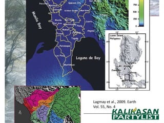
Lagmay et al., 2009. Earth
Vol. 55, No. 4
Tabios, 2009. National Hydraulic Research Center
Precipitation = Run-off +Abstraction +
          Evapotranspiration
Abstraction:
Infiltration + Depression Storage + Interception

Run-off Volume Calculation:
Run-off coefficient = 0.8
Marikina watershed area = 535 km2 = 535000000 m2
Rainfall (24 hours) = 500 mm = 0.5 m
Volume = 0.5 x 535000000 = 267500000 m3
Run-off volume = 267500000 x 0.8 m3 = 214,000,000 m3
Roughness Effect (shanties, stream
           bed substrate)
        Q = A*V
Where A is cross-sectional area (m2) and V is velocity (m/s).
This is similar to Manning’s equation as:
        Q = (1/n) AR(2/3)So(1/2)

Where n = roughness coefficient accounts for the roughness
of the channel or surface where the water is flowing
R = hydraulic radius
So = bed slope.
From (3) and (4), the velocity (V) is:
        V = (1/n) R(2/3)So(1/2)
What can be done
• Precipitation is the primary determinant of
  flooding and not the shanties
  – With the volume of water, the floodplains will
    surely be flooded with or without the houses
    along the banks and in the waterways
• Engineering solutions, early warning systems
  and reduction of vulnerability
  – Flood drills, community preparation and disaster
    management

More Related Content

What's hot

Geotechnical Engineering-I [Lec #27A: Flow Calculation From Flow Nets]
Geotechnical Engineering-I [Lec #27A: Flow Calculation From Flow Nets]Geotechnical Engineering-I [Lec #27A: Flow Calculation From Flow Nets]
Geotechnical Engineering-I [Lec #27A: Flow Calculation From Flow Nets]Muhammad Irfan
 
Effects of Uncertainty in Cloud Microphysics on Passive Microwave Rainfall Me...
Effects of Uncertainty in Cloud Microphysics on Passive Microwave Rainfall Me...Effects of Uncertainty in Cloud Microphysics on Passive Microwave Rainfall Me...
Effects of Uncertainty in Cloud Microphysics on Passive Microwave Rainfall Me...grssieee
 
SImulating Past Flood Event using Nays 2D Flood
SImulating Past Flood Event using Nays 2D FloodSImulating Past Flood Event using Nays 2D Flood
SImulating Past Flood Event using Nays 2D FloodPutika Ashfar Khoiri
 
Simulating several flood events using Nays 2D Flood
Simulating several flood events using Nays 2D FloodSimulating several flood events using Nays 2D Flood
Simulating several flood events using Nays 2D FloodPutika Ashfar Khoiri
 
DSD-INT 2015 - Model-supported monitoring of coastal turbidity during extensi...
DSD-INT 2015 - Model-supported monitoring of coastal turbidity during extensi...DSD-INT 2015 - Model-supported monitoring of coastal turbidity during extensi...
DSD-INT 2015 - Model-supported monitoring of coastal turbidity during extensi...Deltares
 
DSD-INT 2016 Integrating information sources for inland waters modelling - Ba...
DSD-INT 2016 Integrating information sources for inland waters modelling - Ba...DSD-INT 2016 Integrating information sources for inland waters modelling - Ba...
DSD-INT 2016 Integrating information sources for inland waters modelling - Ba...Deltares
 
DSD-INT 2015 - Monitoring Maasvlakte 2 impact - IR. William Borst
DSD-INT 2015 - Monitoring Maasvlakte 2 impact - IR. William Borst DSD-INT 2015 - Monitoring Maasvlakte 2 impact - IR. William Borst
DSD-INT 2015 - Monitoring Maasvlakte 2 impact - IR. William Borst Deltares
 
CTF = no-till with better porosity, aeration and drainage. Jeff Tullberg
CTF = no-till with better porosity, aeration and drainage. Jeff TullbergCTF = no-till with better porosity, aeration and drainage. Jeff Tullberg
CTF = no-till with better porosity, aeration and drainage. Jeff TullbergJoanna Hicks
 
Geotechnical engineering numerical
Geotechnical engineering numerical Geotechnical engineering numerical
Geotechnical engineering numerical wasim shaikh
 
DSD-INT 2016 Data assimilation to improve volcanic ash forecasts using LOTOS-...
DSD-INT 2016 Data assimilation to improve volcanic ash forecasts using LOTOS-...DSD-INT 2016 Data assimilation to improve volcanic ash forecasts using LOTOS-...
DSD-INT 2016 Data assimilation to improve volcanic ash forecasts using LOTOS-...Deltares
 
Application of the random walk theory for simulation of flood hazzards jeddah...
Application of the random walk theory for simulation of flood hazzards jeddah...Application of the random walk theory for simulation of flood hazzards jeddah...
Application of the random walk theory for simulation of flood hazzards jeddah...Amro Elfeki
 
Nir y. krakauer
Nir y. krakauerNir y. krakauer
Nir y. krakauerClimDev15
 
Development of a soil carbon map for the United Republic of Tanzania
Development of a soil carbon map for the United Republic of TanzaniaDevelopment of a soil carbon map for the United Republic of Tanzania
Development of a soil carbon map for the United Republic of TanzaniaExternalEvents
 
Poster_version_3 (5)
Poster_version_3 (5)Poster_version_3 (5)
Poster_version_3 (5)Yitan Wang
 
Discharge Under a Sluice Gate | Jameel Academy
Discharge Under a Sluice Gate | Jameel AcademyDischarge Under a Sluice Gate | Jameel Academy
Discharge Under a Sluice Gate | Jameel AcademyJameel Academy
 
DSD-INT 2016 The eWaterCyle global Hydrological forecasting system - Drost
DSD-INT 2016 The eWaterCyle global Hydrological forecasting system - DrostDSD-INT 2016 The eWaterCyle global Hydrological forecasting system - Drost
DSD-INT 2016 The eWaterCyle global Hydrological forecasting system - DrostDeltares
 
DSD-INT 2017 Contaminant transport modelling in the Port of Rotterdam - devel...
DSD-INT 2017 Contaminant transport modelling in the Port of Rotterdam - devel...DSD-INT 2017 Contaminant transport modelling in the Port of Rotterdam - devel...
DSD-INT 2017 Contaminant transport modelling in the Port of Rotterdam - devel...Deltares
 

What's hot (20)

Geotechnical Engineering-I [Lec #27A: Flow Calculation From Flow Nets]
Geotechnical Engineering-I [Lec #27A: Flow Calculation From Flow Nets]Geotechnical Engineering-I [Lec #27A: Flow Calculation From Flow Nets]
Geotechnical Engineering-I [Lec #27A: Flow Calculation From Flow Nets]
 
Effects of Uncertainty in Cloud Microphysics on Passive Microwave Rainfall Me...
Effects of Uncertainty in Cloud Microphysics on Passive Microwave Rainfall Me...Effects of Uncertainty in Cloud Microphysics on Passive Microwave Rainfall Me...
Effects of Uncertainty in Cloud Microphysics on Passive Microwave Rainfall Me...
 
SImulating Past Flood Event using Nays 2D Flood
SImulating Past Flood Event using Nays 2D FloodSImulating Past Flood Event using Nays 2D Flood
SImulating Past Flood Event using Nays 2D Flood
 
Soil and Water Engineering 03
Soil and Water Engineering  03Soil and Water Engineering  03
Soil and Water Engineering 03
 
Simulating several flood events using Nays 2D Flood
Simulating several flood events using Nays 2D FloodSimulating several flood events using Nays 2D Flood
Simulating several flood events using Nays 2D Flood
 
DSD-INT 2015 - Model-supported monitoring of coastal turbidity during extensi...
DSD-INT 2015 - Model-supported monitoring of coastal turbidity during extensi...DSD-INT 2015 - Model-supported monitoring of coastal turbidity during extensi...
DSD-INT 2015 - Model-supported monitoring of coastal turbidity during extensi...
 
DSD-INT 2016 Integrating information sources for inland waters modelling - Ba...
DSD-INT 2016 Integrating information sources for inland waters modelling - Ba...DSD-INT 2016 Integrating information sources for inland waters modelling - Ba...
DSD-INT 2016 Integrating information sources for inland waters modelling - Ba...
 
DSD-INT 2015 - Monitoring Maasvlakte 2 impact - IR. William Borst
DSD-INT 2015 - Monitoring Maasvlakte 2 impact - IR. William Borst DSD-INT 2015 - Monitoring Maasvlakte 2 impact - IR. William Borst
DSD-INT 2015 - Monitoring Maasvlakte 2 impact - IR. William Borst
 
Updating the curve number method for rainfall runoff estimation
Updating the curve number method for rainfall runoff estimationUpdating the curve number method for rainfall runoff estimation
Updating the curve number method for rainfall runoff estimation
 
CTF = no-till with better porosity, aeration and drainage. Jeff Tullberg
CTF = no-till with better porosity, aeration and drainage. Jeff TullbergCTF = no-till with better porosity, aeration and drainage. Jeff Tullberg
CTF = no-till with better porosity, aeration and drainage. Jeff Tullberg
 
Geotechnical engineering numerical
Geotechnical engineering numerical Geotechnical engineering numerical
Geotechnical engineering numerical
 
DSD-INT 2016 Data assimilation to improve volcanic ash forecasts using LOTOS-...
DSD-INT 2016 Data assimilation to improve volcanic ash forecasts using LOTOS-...DSD-INT 2016 Data assimilation to improve volcanic ash forecasts using LOTOS-...
DSD-INT 2016 Data assimilation to improve volcanic ash forecasts using LOTOS-...
 
Application of the random walk theory for simulation of flood hazzards jeddah...
Application of the random walk theory for simulation of flood hazzards jeddah...Application of the random walk theory for simulation of flood hazzards jeddah...
Application of the random walk theory for simulation of flood hazzards jeddah...
 
Nir y. krakauer
Nir y. krakauerNir y. krakauer
Nir y. krakauer
 
Development of a soil carbon map for the United Republic of Tanzania
Development of a soil carbon map for the United Republic of TanzaniaDevelopment of a soil carbon map for the United Republic of Tanzania
Development of a soil carbon map for the United Republic of Tanzania
 
Poster_version_3 (5)
Poster_version_3 (5)Poster_version_3 (5)
Poster_version_3 (5)
 
Pre-Injection Assessment of Time-Lapse Seismic Repeatability at the Aquistore...
Pre-Injection Assessment of Time-Lapse Seismic Repeatability at the Aquistore...Pre-Injection Assessment of Time-Lapse Seismic Repeatability at the Aquistore...
Pre-Injection Assessment of Time-Lapse Seismic Repeatability at the Aquistore...
 
Discharge Under a Sluice Gate | Jameel Academy
Discharge Under a Sluice Gate | Jameel AcademyDischarge Under a Sluice Gate | Jameel Academy
Discharge Under a Sluice Gate | Jameel Academy
 
DSD-INT 2016 The eWaterCyle global Hydrological forecasting system - Drost
DSD-INT 2016 The eWaterCyle global Hydrological forecasting system - DrostDSD-INT 2016 The eWaterCyle global Hydrological forecasting system - Drost
DSD-INT 2016 The eWaterCyle global Hydrological forecasting system - Drost
 
DSD-INT 2017 Contaminant transport modelling in the Port of Rotterdam - devel...
DSD-INT 2017 Contaminant transport modelling in the Port of Rotterdam - devel...DSD-INT 2017 Contaminant transport modelling in the Port of Rotterdam - devel...
DSD-INT 2017 Contaminant transport modelling in the Port of Rotterdam - devel...
 

Viewers also liked

Viewers also liked (7)

Stateofsnt
StateofsntStateofsnt
Stateofsnt
 
Reading
ReadingReading
Reading
 
Norma riego n ch1333 1978-mod-1987
Norma riego n ch1333 1978-mod-1987Norma riego n ch1333 1978-mod-1987
Norma riego n ch1333 1978-mod-1987
 
Listening3
Listening3Listening3
Listening3
 
Folding!!!
Folding!!!Folding!!!
Folding!!!
 
Diseño y ensayo de uniones para
Diseño y ensayo de uniones paraDiseño y ensayo de uniones para
Diseño y ensayo de uniones para
 
Writing
WritingWriting
Writing
 

Similar to Gener

Hydrology (Estimation of peak flood discharge)
Hydrology (Estimation of peak flood discharge)Hydrology (Estimation of peak flood discharge)
Hydrology (Estimation of peak flood discharge)Latif Hyder Wadho
 
Assignment applied hydrology
Assignment applied hydrologyAssignment applied hydrology
Assignment applied hydrologyAtif Satti
 
UnitHydrograph.pptx
UnitHydrograph.pptxUnitHydrograph.pptx
UnitHydrograph.pptxssuserdf29f0
 
Integrated hydro-geological risk for Mallero (Alpine Italy) – part 1: geology
Integrated hydro-geological risk for Mallero (Alpine Italy) – part 1: geologyIntegrated hydro-geological risk for Mallero (Alpine Italy) – part 1: geology
Integrated hydro-geological risk for Mallero (Alpine Italy) – part 1: geologyMaryam Izadifar
 
Integrated hydro-geological risk for Mallero basin (Alpine Italy) – part 1: g...
Integrated hydro-geological risk for Mallero basin (Alpine Italy) – part 1: g...Integrated hydro-geological risk for Mallero basin (Alpine Italy) – part 1: g...
Integrated hydro-geological risk for Mallero basin (Alpine Italy) – part 1: g...Alireza Babaee
 
Ground water hydrology .docx
Ground water hydrology .docxGround water hydrology .docx
Ground water hydrology .docxChanakoDane
 
T7: Flood Risk Assessment Using GIS Tools
T7: Flood Risk Assessment Using GIS ToolsT7: Flood Risk Assessment Using GIS Tools
T7: Flood Risk Assessment Using GIS ToolsFAO
 
07 a80102 groundwaterdevelopmentandmanagement
07 a80102 groundwaterdevelopmentandmanagement07 a80102 groundwaterdevelopmentandmanagement
07 a80102 groundwaterdevelopmentandmanagementimaduddin91
 
WE3.L09 - RAIN EFFECT ON POLARIMETRIC SAR OBSERVATION
WE3.L09 - RAIN EFFECT ON POLARIMETRIC SAR OBSERVATIONWE3.L09 - RAIN EFFECT ON POLARIMETRIC SAR OBSERVATION
WE3.L09 - RAIN EFFECT ON POLARIMETRIC SAR OBSERVATIONgrssieee
 
DSD-INT 2019 Modeling vegetation controls on gravel bed river morphodynamics ...
DSD-INT 2019 Modeling vegetation controls on gravel bed river morphodynamics ...DSD-INT 2019 Modeling vegetation controls on gravel bed river morphodynamics ...
DSD-INT 2019 Modeling vegetation controls on gravel bed river morphodynamics ...Deltares
 
Cfd simulation for cavitation of propeller blade gjitcs
Cfd simulation for cavitation of propeller blade gjitcsCfd simulation for cavitation of propeller blade gjitcs
Cfd simulation for cavitation of propeller blade gjitcsOladokun Sulaiman Olanrewaju
 
Lec.01.introduction to hydrology
Lec.01.introduction to hydrologyLec.01.introduction to hydrology
Lec.01.introduction to hydrologyEngr Yasir shah
 
Assignment_01_Hydrology_Ch03_Solution (1).pdf
Assignment_01_Hydrology_Ch03_Solution (1).pdfAssignment_01_Hydrology_Ch03_Solution (1).pdf
Assignment_01_Hydrology_Ch03_Solution (1).pdfPRAVABBUDHATHOKI
 
Assignment_01_Hydrology_Ch03_Solution.pdf
Assignment_01_Hydrology_Ch03_Solution.pdfAssignment_01_Hydrology_Ch03_Solution.pdf
Assignment_01_Hydrology_Ch03_Solution.pdfPRAVABBUDHATHOKI
 

Similar to Gener (20)

Hydrology (Estimation of peak flood discharge)
Hydrology (Estimation of peak flood discharge)Hydrology (Estimation of peak flood discharge)
Hydrology (Estimation of peak flood discharge)
 
Hydrology ( Hydro graph )
Hydrology ( Hydro graph )Hydrology ( Hydro graph )
Hydrology ( Hydro graph )
 
Assignment applied hydrology
Assignment applied hydrologyAssignment applied hydrology
Assignment applied hydrology
 
UnitHydrograph.pptx
UnitHydrograph.pptxUnitHydrograph.pptx
UnitHydrograph.pptx
 
Integrated hydro-geological risk for Mallero (Alpine Italy) – part 1: geology
Integrated hydro-geological risk for Mallero (Alpine Italy) – part 1: geologyIntegrated hydro-geological risk for Mallero (Alpine Italy) – part 1: geology
Integrated hydro-geological risk for Mallero (Alpine Italy) – part 1: geology
 
Integrated hydro-geological risk for Mallero basin (Alpine Italy) – part 1: g...
Integrated hydro-geological risk for Mallero basin (Alpine Italy) – part 1: g...Integrated hydro-geological risk for Mallero basin (Alpine Italy) – part 1: g...
Integrated hydro-geological risk for Mallero basin (Alpine Italy) – part 1: g...
 
WATERSHED CATCHMENT.pptx
WATERSHED CATCHMENT.pptxWATERSHED CATCHMENT.pptx
WATERSHED CATCHMENT.pptx
 
WATERSHED CATCHMENT.pdf
WATERSHED CATCHMENT.pdfWATERSHED CATCHMENT.pdf
WATERSHED CATCHMENT.pdf
 
Unit source area monitoring
Unit source area monitoringUnit source area monitoring
Unit source area monitoring
 
Ground water hydrology .docx
Ground water hydrology .docxGround water hydrology .docx
Ground water hydrology .docx
 
T7: Flood Risk Assessment Using GIS Tools
T7: Flood Risk Assessment Using GIS ToolsT7: Flood Risk Assessment Using GIS Tools
T7: Flood Risk Assessment Using GIS Tools
 
07 a80102 groundwaterdevelopmentandmanagement
07 a80102 groundwaterdevelopmentandmanagement07 a80102 groundwaterdevelopmentandmanagement
07 a80102 groundwaterdevelopmentandmanagement
 
WE3.L09 - RAIN EFFECT ON POLARIMETRIC SAR OBSERVATION
WE3.L09 - RAIN EFFECT ON POLARIMETRIC SAR OBSERVATIONWE3.L09 - RAIN EFFECT ON POLARIMETRIC SAR OBSERVATION
WE3.L09 - RAIN EFFECT ON POLARIMETRIC SAR OBSERVATION
 
DSD-INT 2019 Modeling vegetation controls on gravel bed river morphodynamics ...
DSD-INT 2019 Modeling vegetation controls on gravel bed river morphodynamics ...DSD-INT 2019 Modeling vegetation controls on gravel bed river morphodynamics ...
DSD-INT 2019 Modeling vegetation controls on gravel bed river morphodynamics ...
 
Cfd simulation for cavitation of propeller blade gjitcs
Cfd simulation for cavitation of propeller blade gjitcsCfd simulation for cavitation of propeller blade gjitcs
Cfd simulation for cavitation of propeller blade gjitcs
 
Unit operation
Unit operationUnit operation
Unit operation
 
Lec.01.introduction to hydrology
Lec.01.introduction to hydrologyLec.01.introduction to hydrology
Lec.01.introduction to hydrology
 
Combined experimental and modeling procedure
Combined experimental and modeling procedureCombined experimental and modeling procedure
Combined experimental and modeling procedure
 
Assignment_01_Hydrology_Ch03_Solution (1).pdf
Assignment_01_Hydrology_Ch03_Solution (1).pdfAssignment_01_Hydrology_Ch03_Solution (1).pdf
Assignment_01_Hydrology_Ch03_Solution (1).pdf
 
Assignment_01_Hydrology_Ch03_Solution.pdf
Assignment_01_Hydrology_Ch03_Solution.pdfAssignment_01_Hydrology_Ch03_Solution.pdf
Assignment_01_Hydrology_Ch03_Solution.pdf
 

Gener

  • 1. Lagmay et al., 2009. Earth Vol. 55, No. 4
  • 2. Tabios, 2009. National Hydraulic Research Center
  • 3. Precipitation = Run-off +Abstraction + Evapotranspiration Abstraction: Infiltration + Depression Storage + Interception Run-off Volume Calculation: Run-off coefficient = 0.8 Marikina watershed area = 535 km2 = 535000000 m2 Rainfall (24 hours) = 500 mm = 0.5 m Volume = 0.5 x 535000000 = 267500000 m3 Run-off volume = 267500000 x 0.8 m3 = 214,000,000 m3
  • 4. Roughness Effect (shanties, stream bed substrate) Q = A*V Where A is cross-sectional area (m2) and V is velocity (m/s). This is similar to Manning’s equation as: Q = (1/n) AR(2/3)So(1/2) Where n = roughness coefficient accounts for the roughness of the channel or surface where the water is flowing R = hydraulic radius So = bed slope. From (3) and (4), the velocity (V) is: V = (1/n) R(2/3)So(1/2)
  • 5. What can be done • Precipitation is the primary determinant of flooding and not the shanties – With the volume of water, the floodplains will surely be flooded with or without the houses along the banks and in the waterways • Engineering solutions, early warning systems and reduction of vulnerability – Flood drills, community preparation and disaster management