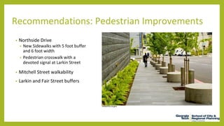
CASTLEBERRY HILL
Land Use Plan
Recommendations by Caroline Burnette, Joshua Haston,
Julia Garver, and Chul Hong Park
Castleberry Hill Boundaries
Existing Conditions: Land Use and Zoning
Existing Conditions: Demographics
Existing Conditions: Property Values
Property Values Per Parcel
2005 2014
Existing Conditions: Sidewalks
Activity: Measurement Method
Pedestrian
Automobile
Activity: Pedestrian map
• Morning Rush hour and
Afternoon Rush hour low
• Weekends High
• Pedestrian Activity
Concentrates within Peter
St. and Walker St.
Activity: Pedestrian map
Activity: Automobile map
• Weekday evening and
Saturday evening low on
automobile activity
• Morning rush hour and
Sunday afternoon high on
automobile activity
Activity: Automobile map
• Automobile Activity high
on Walker Street
• Medium on Peters Street
• Low on other region
Activity Areas and Build-Out
Built Environment by Parcel
Commercial and Mixed-Use Development Residential and Public Space Development
Built Environment by Parcel
Recommendations:
• Encourage new residential development followed by commercial development
• Propose community facilities for existing vacant and underutilized public space
• Promote “convertible spaces”1
that can be transformed from residential to mixed use once demand is
met
Commercial and Mixed-Use Development Residential and Public Space Development
1
For additional information regarding convertible spaces, please see the Chamblee, GA municode (https://www.municode.com/library/ga/chamblee/codes/code_of_ordinances) and the Urban
Land Institute’s article “Universal Structures as Long-Term Sustainable Assets” (http://urbanland.uli.org/planning-design/universal-structures-long-term-sustainable-assets/)
Built Environment by Parcel
Vacancy Map Allowable Floor-Area Ratio Map
Built Environment by Parcel
Recommendations:
• Propose high density multi-family residential development within high-FAR, vacant lots in the southwest corner of
the neighborhood
• Suggest mixed-use and public space development just north of Nelson Street to link activities along Northside
Drive to Landmark District
• Keep existing zoning intact
Vacancy Map Allowable Floor-Area Ratio Map
Recommendations: Complete Streets
completestre
etsnc.org
36 Foot Road Width:
56 Foot Road Width:
• What are complete streets?
• 36 Foot Road Sections:
• Mitchell Street
• Southern portions of Walker Street
• 56 Foot Road Sections:
• Peters Street
• Northern Walker Street / Centennial Park Drive
Recommendations: Pedestrian Improvements
• Northside Drive
• New Sidewalks with 5 foot buffer
and 6 foot width
• Pedestrian crosswalk with a
devoted signal at Larkin Street
• Mitchell Street walkability
• Larkin and Fair Street buffers
slowotta.ca.gov
Recommendations: Future Land Uses, Development
Goals, and Policy
• Open dialogue with The City of
Atlanta and developers to
encourage the implementation of
neighborhood goals into the
projects.
• Adopt development goals and
policies to direct future
development and preserve the
neighborhood character, while also
improving the sustainability of the
neighborhood.
• Promote convertible land uses
until commercial market can be
supported
• Attract developers to build a
grocery store, community center,
more multi-family housing
• Seek funding for the construction
of two parks on currently vacant
parcels.
Questions?

Final Presentation.pptx

  • 1.
    CASTLEBERRY HILL Land UsePlan Recommendations by Caroline Burnette, Joshua Haston, Julia Garver, and Chul Hong Park
  • 2.
  • 3.
  • 4.
  • 5.
    Existing Conditions: PropertyValues Property Values Per Parcel 2005 2014
  • 6.
  • 7.
  • 8.
    Activity: Pedestrian map •Morning Rush hour and Afternoon Rush hour low • Weekends High
  • 9.
    • Pedestrian Activity Concentrateswithin Peter St. and Walker St. Activity: Pedestrian map
  • 10.
    Activity: Automobile map •Weekday evening and Saturday evening low on automobile activity • Morning rush hour and Sunday afternoon high on automobile activity
  • 11.
    Activity: Automobile map •Automobile Activity high on Walker Street • Medium on Peters Street • Low on other region
  • 12.
  • 13.
    Built Environment byParcel Commercial and Mixed-Use Development Residential and Public Space Development
  • 14.
    Built Environment byParcel Recommendations: • Encourage new residential development followed by commercial development • Propose community facilities for existing vacant and underutilized public space • Promote “convertible spaces”1 that can be transformed from residential to mixed use once demand is met Commercial and Mixed-Use Development Residential and Public Space Development 1 For additional information regarding convertible spaces, please see the Chamblee, GA municode (https://www.municode.com/library/ga/chamblee/codes/code_of_ordinances) and the Urban Land Institute’s article “Universal Structures as Long-Term Sustainable Assets” (http://urbanland.uli.org/planning-design/universal-structures-long-term-sustainable-assets/)
  • 15.
    Built Environment byParcel Vacancy Map Allowable Floor-Area Ratio Map
  • 16.
    Built Environment byParcel Recommendations: • Propose high density multi-family residential development within high-FAR, vacant lots in the southwest corner of the neighborhood • Suggest mixed-use and public space development just north of Nelson Street to link activities along Northside Drive to Landmark District • Keep existing zoning intact Vacancy Map Allowable Floor-Area Ratio Map
  • 17.
    Recommendations: Complete Streets completestre etsnc.org 36Foot Road Width: 56 Foot Road Width: • What are complete streets? • 36 Foot Road Sections: • Mitchell Street • Southern portions of Walker Street • 56 Foot Road Sections: • Peters Street • Northern Walker Street / Centennial Park Drive
  • 18.
    Recommendations: Pedestrian Improvements •Northside Drive • New Sidewalks with 5 foot buffer and 6 foot width • Pedestrian crosswalk with a devoted signal at Larkin Street • Mitchell Street walkability • Larkin and Fair Street buffers slowotta.ca.gov
  • 19.
    Recommendations: Future LandUses, Development Goals, and Policy • Open dialogue with The City of Atlanta and developers to encourage the implementation of neighborhood goals into the projects. • Adopt development goals and policies to direct future development and preserve the neighborhood character, while also improving the sustainability of the neighborhood. • Promote convertible land uses until commercial market can be supported • Attract developers to build a grocery store, community center, more multi-family housing • Seek funding for the construction of two parks on currently vacant parcels.
  • 20.