1. 1,700
900
1,000
1,100
1,200
1,300
1,400
1,500
1,600
1,700
900
1,000
1,100
1,200
1,300
1,400
1,500
1,600
200 400 600 800 1,000 1,200 1,400 1,600 1,800 2,000 2,200 2,400 2,600 2,800 3,000 3,200 3,400 3,600 3,800 4,000 4,200 4,400 4,600 4,800 5,0000 5,200
1,800
1,000
1,200
1,300
1,400
1,500
1,600
1,700
2,000
1,900
2,100
400
500
600
700
800
900
1,800
1,000
1,200
1,300
1,400
1,500
1,600
1,700
2,000
1,900
2,100
400
500
600
700
800
900
200 400 600 800 1,000 1,200 1,400 1,600 1,800 2.000 2,200 2,400 2,600 2,800 3,000 3,200 3,400 3.600 3,800 4,000 4,200 4,400 4,600 4,800 5,0000 5,200 5,400
SCALE
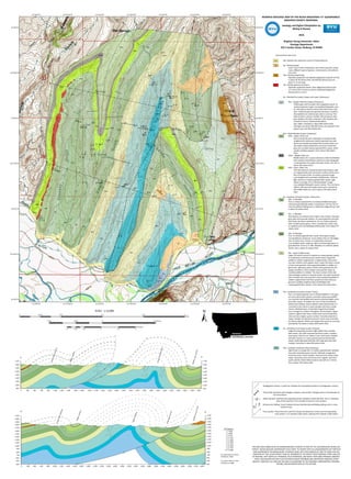
Thrust fault: Solid line with triangles indicates a thrust fault. Triangles point in the direction of
the thrust block.
Strike-slip fault: Solid line with opposing arrows indicates a strike-slip fault. This is a birdseye
view of the map and is not included on the the cross-sections.
DESCRIPTION OF MAP UNITS
Qal
Tg
Tkb
Tki
Kbv
Kbfu
Kbfm
Kbfl
Kkd
Kkc
Kkb
Kka
Trd
Pp
PPq
Qal--Quarternary sediments consist of fluvial deposits
Tg—Tertiary gravels
Cover much of the northeastern area of the map and contain
many different types of igneous, metamorphic, and sedimen
tary rocks.
Tkb—Tertiary basalt flows
Aphanitic porphyritic hornblende-plagioclase andesite sill that
is about 20-30 meters thick. Hornblende phenocrysts are
about 2-12 mm long.
Tki—Tertiary igneous intrusions
Aphanitic porphyritic basalt. Clear plagioclase phenocrysts
(3-5 mm) exist in matrix as well as weathered plagioclase
phenocrysts (1-2 mm).
Kb – Blackleaf Formation (Upper and Lower Cretaceous)
Kbv – Vaughn Member (Upper Cretaceous)
Pinkish gray, well-rounded, clast-supported coarse- to
medium-grained trough cross-bedded feldspathic aren
ite. Dark gray to black mudrock with dark brown inclu
sions. Greenish gray, fine-grained calcareous mudrock
that weathers to a dark brown color in outcrop. Thin
beds of pink to maroon rhyolitic tuff and gray to dark
gray rhyolitic tuff. Both contained <10% sanadine phe
nocrysts (2-3mm). Volcanoclastic debris
also visible. Formation is about 600 meters thick,
although only about 100-200 meters are exposed in the
project area near Block Mountain.
Kbf – Flood Member (Lower Cretaceous)
Kbfu – Upper clastic unit
Gray to brownish pink moderately cemented locally
conglomeritic calcareous medium-grained cross-bed
ded to horizontally laminated lithic arenite, which usu
ally cleaves along sedimentary structures. Brownish
gray sub-rounded medium-grained lithic wacke, which
rounds and fines upward. Unit is about 100 meters
thick.
Kbfm – Middle shale unit
Middle shale unit is a gray calcareous shale interbedded
with mudrock and siltstone and forms a low topograph
ic area between the upper and lower clastic unit. Unit is
about 100 meters thick.
Kbfl – Lower clastic unit
Thin discontinuous limestone beds exist locally as well
as conglomerates with calcareous mudrock clasts and a
thin (<5 ft) bed of fine- to medium-grained trough
cross-bedded well-cemented sublitharenite. Green to
light red fine-to medium-grained lithic wacke. Light
brown to orange, thin to thickly bedded, trough
cross-bedded feldspathic quartz arenite. This unit forms
distinct cliffs about 50 meters thick and is overlain by
the middle shale unit. Unit is about 150 meters thick
total.
Kk – Kootenai Formation (Lower Cretaceous)
Kkd – D Member
Fine to medium-grained thin to medium-bedded dark gray
calcareous gastropodal wacke- to packstone. Unit has lots of
inter-formational folding and is a distinctive ledge-former. Unit
is about 30 meters thick.
Kkc – C Member
Red siltstone to mudrock that is high in clay content. Greenish
gray, pale red to purple medium- to coarse-grained cross-bed
ded sandy calcareous wackestone. Fine to medium-grained
well-rounded quartz grains. Lithics rounded also. Beds coars
en upwards and cross-bedding visible locally. Unit is about 50
meters thick.
Kkb – B Member
Fine- to medium-grained lithic wacke. Olive green to gray
non-fossiliferous limestone. Forms distinct thin (2-4 ft) ledges.
Lots of calcite veins. Poorly- to moderately-cemented
cross-bedded clastic andstone. Well-cemented light green to
gray dolomite. Forms 2-3’ cliffs. Weathers to a distinct yellow
brown. Unit is about 70 meters thick.
Kka – Basal Conglomerate
Upper 30 meters consist of medium to coarse-grained, poorly-
to moderately-cemented poorly sorted matrix-supported
pebble to cobble conglomerate. Conglomerate is discontinu
ous and contains more angular clasts. Lower 40 meters consist
of chert and quartzite clast-supported pebble to cobble con
glomerate. Light gray, poorly sorted coarse-grained salt and
pepper sandstone. Chert nodules and quartzite make up
rounded pebbles to cobbles. The lower contact of this sedi
ment package consists of a poorly-sorted, very well-cemented
well-rounded chert and quartzite matrix-supported pebble to
cobble conglomerate that fines upward into discontinuous
granule to pebble conglomerates interbedded with
coarse-grained lithic arenite. Unit is about 50 meters thick.
Trd – Dinwoody Formation (Lower Triassic)
Fine- to medium-grained, thin to thickly-bedded (1’-10’) gray
ish red to dark brown poorly-cemented calcareous fossilifer
ous mudrock interbedded with poorly-cemented highly calcar
eous lithic wacke. Formation has a lot of inter-formational
disharmonic folding. Various tabular calcite phenocrysts (<3
mm) exist in the matrix in some samples and have a sandy
texture. Multiple layers of abundant lingoid brachiopods
occur, though not uniform throughout the formation. Upper
contact is lighter than lower contact and can be locally dolo
mitic and has a higher quartz content. Formation does form
slopes, though not well-pronounced in some areas and deep
ens (fines) upward. White and orange lichen grow on outcrops
abundantly. Formation is about 200 meters thick.
Pp – Phosphoria Formation (Lower Permian)
Ledge-forming bluish purple to light yellow Sub-rounded,
well-sorted, very well-cemented and lithic wacke. Contains
some grains that are red. Yellow to tan chert layers interbed
ded with medium- to coarse-grained well-cemented lithic
wacke. Sandy light gray dolomite with large spherical chert
nodules. Formation is about 80 meters thick.
PPq – Quadrant Sandstone (Pennsylvanian)
Light brown to orange fine- to medium-grained well-rounded,
very well-cemented quartz arenite. Yellowish orange dirty
inclusions exist in hand samples. Outcrop forms blocky steep
slopes. Quartzite exists and tends to be a lighter color than
quartz arenite. Green lichen tends to row well on it. Forma
tion is about 150 meters thick.
Feet Meters
1
2
3
4
5
6
7
8
9
10
.3048
.6096
.9144
1.2192
1.5240
1.8288
2.1336
2.4384
2.7432
3.0480
To convert feet to meters
multiply by .3048
To convert meters to feet
multiply by 3.2808
Geology and Digital COmpilation by
McKay B Tenney
2016
Brigham Young University--Idaho
Geology Department
525 S Center Street, Rexburg, ID 83440
Disharmonic folding: Curves indicate intense interformational folding withing units in cross-
sectional view.
MONTANA
QUADRANGLE LOCATION
THIS MAP WAS COMPILED BY AN UNDERGRADUATE STUDENT AS PART OF THE 2016 BRIGHAM YOUNG UNI-
VERSITY--IDAHO GEOLOGY DEPARTMENT FIELD CAMP TO COMPLY WITH ALL REQUIREMENTS SET FORTH BY
SAID DEPARTMENT FOR GRADUATION. STUDENTS WERE SPLIT INTO GROUPS OF TWO TO THREE FOR THE
DURATION OF THIS 10-DAY PROJECT AND ALL MEMBERS OF THE GROUP TOOK PERSONAL STRIKE AND DIP
OF BEDDING, KEPT NOTES IN A PERSONAL FIELD NOTEBOOK, AND MADE THEIR OWN PERSONAL OBSERVA-
TIONS. DISCUSSIONS DID TAKE PLACE BETWEEN GROUP MEMBERS AND SOMETIMES AMOUNG OTHER
GROUPS. HOWEVER, ALL DATA ON THIS MAP IS ACCORDING TO THE PERSONAL OBSERVATIONS, INTERPRE-
TATIONS, AND RECORDED DATA OF THE AUTHOR.
A A’
B B’
Stratigraphic Contact: A solid line indicates the interpreted position of stratigraphic contacts
A
A’
Cross section: These lines (A-A’ and B-B’) locate the placement of the each corresponding
cross section. A-A’ extends 5,285 meters, whereas B-B’ extends 5,500 meters.
BEDROCK GEOLOGIC MAP OF THE BLOCK MOUNTAIN 7.5’ QUADRANGLE
MADISON COUNTY, MONTANA
Zieglersyncline
Ziegleranticline
CoalDrawsyncline
SandyHollowanticline
BuffaloJumpsyncline
CreasyGulchanticline
CreasyGulchanticline
Zieglersyncline
BuffaloJumpsyncline
(( (( (( ((
((
((
((
((
((
((
((
((
((
((
((
((
((
((
((
((
((
((((((((((((((((((
((
((((((((((((((((((((
((
((
((
((((
((
((
((((((
((
((
((
((
((
((
(( (( ((
(( (( ((
((
((
((
((
((
(( (( (( ((
((
((
((
((
((
((
((((((((((((((((((((((((((((((((((((((((((((
((
((
((
((
((
((
((
((
((
((
((
((
((
((
((
((
((
((((((((((((
((
((((((((
((
((
((
((
((
((
((
((
((
((
((
((
((
((
((
((
((
((
((
((
((
á
á
á
áá
ááá
á
á
á
á á
á
á
á
á
á
á
á
á
á
á
á
á á
á
á
á
á
á
á á
á
áá á
á áá á
á
á áá á
á
á
á
á
á
á
á á á
á
á
á
áá
á
á
á
á
á
á
á
áá
á
á
á
áá
á
á
á
á
á á
á
á
á
á
á
á
á
á
á
á
ááá
áá
á
á
á
á
á
á
á
M
M
M
F
F
F
60
77
35
30
40
52
53
48
18
37
62 57
70
70
28
20
45
57
63
35
6465
67
81
25
34
56
54 57
55
30
24
36
32
81
17
34
39
29
22
27
27
85
85
32
83
23
25
7984
84
70
79
20
53
40
21
65
44
40
54
4355
55
18
26
36
32
32
7660
59
50
74
26
674862
31
56
1515
25
75
71
44
40
23
45
4830
83
81
80
60
16
15
25
48
12
13
16
112°33'0"W
112°33'0"W
112°33'30"W
112°33'30"W
112°34'0"W
112°34'0"W
112°34'30"W
112°34'30"W
112°35'0"W
112°35'0"W
112°35'30"W
112°35'30"W
112°36'0"W
112°36'0"W
45°29'0"N 45°29'0"N
45°28'30"N 45°28'30"N
45°28'0"N 45°28'0"N
45°27'30"N 45°27'30"N
45°27'0"N 45°27'0"N
45°26'30"N 45°26'30"N
45°26'0"N 45°26'0"N
±0 0.5 1 1.5 20.25
Kilometers
0 0.75 1.5 2.25 30.375
Miles
5,100 0 5,1002,550 Feet
1:12,000
B
B’
A’A
A’
Qal
Tg
Tkb
Tki
Kbv
Kbfu
Kbfm
Kbfl
Kkd
Kkc
Kkb
Kka
Trd
Pp
PPq
Tg
Qal
Pp
Kka
Kkb
Kkb
Kkc
Kkb
Kkc
Kbfl
Kbfm
Kbfu
Kbfl
Tg
Kkd
Kkd
Kkd