SlideShare a Scribd company logo
48
85
88
58
61 5752
50
42
40
50
3237
52
57
42
41
52
21
58
65
87
36
49
453182
41
72
84
88
81
57
06
03
05
12
4223 05
35
30
08
18
20
21
21
16 27
58
21
26
27
42
86
59
43
72 60
56
48
32
39
48
38
45
46
62
21
29
19
35
41 32
52
38
05
03
4758 39
29
33
39
64
68
71
88
62
62 29
03
42
37
13
48
34
84
52
57
57
85
82 50
69
81
39
79
51
33
49
84
6151
78
21
32
40
51
50
62
75
64
51
52
72
64
45
34 41
37 51
47
37
40
85
81
13
56
SCg
X’’
X’
X’
X’’
500
600
700
800
900
1000
1100
1200
500
600
700
800
900
1000
1100
1200
The Geology of Gallégo Gorge,
Aragon, NE Spain
Henry AlexanderTotts
1093797
School of Geography, Earth and Environmental
Science
Map and Cross Sections Scale 1:10 000
0m 100m 200m 300m 400m 500m 1000m
Cross section from X’to X’’, shown on map. Cross section is to scale
Key of Geological Symbols
682 686685684683 688687
685684683682 688687686
692
692
693
694
695
695
694
693
Cleavage
57
Observed Boundary
Inferred Boundary
Thrust Fault Plane
Reverse Fault Plane
Strike-slip Fault Plane
SCg SCg
SCg
SCg
SCg
SCg
GA
GA
GCg
FCg
GCg
FCg
GCg
FCg
FCg
FCg
DLs
DLs
DLs
DLs
DLs
DLs
DLs
KLs
KLs
KLs
KLs
KLs
KLs
KLs
KLs
KLs
KLs
CLs
CLs
CLs
CLs
CLs
CLs CLs
CLs
UCLs
UCLs
UCLs
UCLs
UCLs
UCLs
UCLs
UCLs
UCLs
UCLs
UCLs
RSS
RSS
RSS
RSS
GLs
GLs
GLs
GM
GM
GM
GM
GM
GM
SDS
SDS
USs
USs
USs
SDS
200
300
400
500
600
700
800
900
1000
1100
1200
1300
200
300
400
500
600
700
800
900
1000
1100
1200
1300
Y’ Y’’
Cross section from Y’to Y’’on the map. Drawn to scale.
GM
GM
GM
FCg
SDS
TM
TM
RSS
UCLs
UCLs
UCLs
SDS
CLs
CLsCLs
Overturned Antiform
Showing Way Up of the Synform in Cross Section
DLs
KLs
Ls
UCLs
RSS
GLs
GM
TM
SDS
FCg
USs
SCg
GAQuaternary
Tertiary
Tertiary
Cretaceous
Triassic
Muschelkalk
andKeuper
FormtionsUncastilloFormationCampodarbeFormaitonArguisFormationGarumnFormationUpperCreatceousFormation
GCg
0m100m200m300m400m500m1000m
StratigraphicChartScale1:5000
57
Bedding Strike and Dip
N
Compression from North
Compression from North East
GM
TM
KLs
KLs
KLs
DLs
GLs
RSS
RSS
UCLs
CLs
KLs
DLs
DLs
DLs
DLs
DLs
KLs
KLs
KLs
CLs
CLs
UCLs
UCLs
RSS
GLs
This is an illustrated interpretation, showing the oblique nature of the thrusting. The image explains the folding
of the comparitively shallow thrust fault seen towards the north. The figure above also illustrates how the
compressional forces resulted in the non-cylindrical fold structure, at Pardina de Carcavilla, to form.
Some of the structures not illustrated in the image are in the south east area of the map. The thrusting of the
duplex structure is due to the compressive forces from the east.
This means that the varying direction of the primary compression results in an overall sinistray strike-slip component
to the area.
13
Plunge of Fold Axial Plane and Plunge Azimuth
Synform Fold Axis
Antiform Fold Axis
Overturned Synform
Muschelkalk Formation. Very dark, partially dolomitised limestone
which has characteristics suggesting some Barrovian metamorphism.
Possibly once fossiliferous.
Keuper Formation. Variable composition, pale yellow and siliciclastic in areas as
a Feldspar Greywacke. Lower Keuper Formation has more fine and micritic
areas, which are darker coloured. The textural classification of the darker
areas is a matrix supported wackestone.
C
This member is classified as a dirty micritic limestone, but is non-uniform
composition, with areas of much larger calcitic crystals. Some flecks of
quartz and clay nodules suggest terrestrial input.
Very fine, musterd coloured sugary limestone. Fossiliferous, classified
as a bio-micrite. Textural classification is a matrix supported wackestone.
Very well preserved, large branching corals in isolated outcrops.
Red member of interbedded sandstone and shale. Less compitent than
surrounding limestones, so ductile deformation seen. Red colour indicative
of oxidation, showing a high amount of terrestrial input.
The Guara Limestone Member, is a medium-coarse dark limestone.
Very consolidated, resistant to erosion, so forms large ridges. Identifiable
through fossil content, namely Nummulites and Alveolines. Classified as a
packstone. Turns to a siliciclastic rich bio-micrite throughout deposition.
Is the primary constituant of the clasts supporting the red fanglomerate
towers.
Grey MarlMember, a very fine, quite fossiliferous marl. Good preservation
potential seen by some of the recovered bivalves. Very unconsolidated,
succeptable to severe erosion. Fissility expressed along bedding plane.
Transitional Marl Formation, grain supported, so classified as a packstone.
Expresses a change from shallow marine to fluvial environment.
Santo Domingo Sandstone. Fluvial deposition, braided river system. Contains
both sand and shale. Mostly a medium-coarse grained, brown to grey coloured
fluvial sandstone. The main outcropping member of the large, overturned
synform.
Fanglomerate. Red coloured conglomerate with clast sized ranging from 5cm to
over 1 meter. Clasts are mainly formed of the Guara Limestone Member, deposited
as alluvial fans into a fluvial system. The most identifiable features of the area,
very consolidated. Matrix is fine, calcitic in places. Palaeoflow readings show
radial flow, but trending in a southernly direction.
Grey Conglomerate Member. More eroded than the fanglomerates, with much smaller
clast sizes. Formed from a less consolidated limestone, but still an alluvial fan system.
Uncastillo Sandstone Member is syndepositional with the alluvial fans.
Medium to coarse grained and conglomeratic in areas from post depositional
reworking.
SCg GA
Sandy Conglomerates are Quaternary fluvial reworking of the Uncastillo
Sandstone Member. Very abundant, and are made of clasts of the USs, with a
medium to coarse grained matrix.
Glacial Alluvium Member, showing where areas of the Uncastillo Sandstone
Member have been glacially influenced post deposition. Rock powder is
primary evidence, incredibly fine.
2
Stereonet of the folded beds at X’.
Bedding is dipping steeply in a N direction. Not anomalous because the inner beds
of the fold are overturned, therefore dipping north.
Pole showing the synformal fold axis’
plunge and plunge azimuth, at 122 26
Great circle showing line of best fit through
the poles to bedding.
N
Y’
Y’’
Palaeogene
Neogene
Palaeogene
EmbalsedelaPena
Pardina de Carcavilla
Riglos

More Related Content

What's hot

Rocks
RocksRocks
Rocks
Lexi02
 
Rocks
RocksRocks
Rocks
Lexi02
 
Dotts classification
Dotts classificationDotts classification
Dotts classification
Masoom Shani
 
Reservoir Geology Assessed Practical
Reservoir Geology Assessed PracticalReservoir Geology Assessed Practical
Reservoir Geology Assessed Practical
lwandfluh
 
Mapping Report Lucas Jacobs
Mapping Report Lucas JacobsMapping Report Lucas Jacobs
Mapping Report Lucas Jacobs
Lucas Jacobs
 
Karst aquifers
Karst aquifersKarst aquifers
Karst aquifers
AqibAliNaich
 
Dissertation geological poster
Dissertation geological posterDissertation geological poster
Dissertation geological poster
TomAdamson7
 
Lime stone and sandstone
Lime stone and sandstone Lime stone and sandstone
Lime stone and sandstone
devi prasanth
 
"Sedimentological studies of Pond deposits from Tista river floodplain, Rangp...
"Sedimentological studies of Pond deposits from Tista river floodplain, Rangp..."Sedimentological studies of Pond deposits from Tista river floodplain, Rangp...
"Sedimentological studies of Pond deposits from Tista river floodplain, Rangp...
Pinaki Sahoo
 
Generalized Geology and Profile of a Utica Shale Well in Eastern OH
Generalized Geology and Profile of a Utica Shale Well in Eastern OHGeneralized Geology and Profile of a Utica Shale Well in Eastern OH
Generalized Geology and Profile of a Utica Shale Well in Eastern OH
Marcellus Drilling News
 
The Geology of South Raasay Dissertation
The Geology of South Raasay DissertationThe Geology of South Raasay Dissertation
The Geology of South Raasay Dissertation
Jonathan Edwards
 
Wacke ( graywacke)
Wacke ( graywacke)Wacke ( graywacke)
Wacke ( graywacke)
Mohit Kumar
 
Sedimentary rocks and structures
Sedimentary rocks and structuresSedimentary rocks and structures
Sedimentary rocks and structures
angelabentley
 
Field lab assingment part 2
Field lab assingment part 2Field lab assingment part 2
Field lab assingment part 2
Edward Cox
 
Major Hart Project Salient Points
Major Hart Project Salient PointsMajor Hart Project Salient Points
Major Hart Project Salient Points
BestrocksMineralServices
 
Simplified Québec Geology
Simplified Québec GeologySimplified Québec Geology
Simplified Québec Geology
Mining Matters
 
Wacke ( graywacke)
Wacke ( graywacke)Wacke ( graywacke)
Wacke ( graywacke)
Mohit Kumar
 

What's hot (17)

Rocks
RocksRocks
Rocks
 
Rocks
RocksRocks
Rocks
 
Dotts classification
Dotts classificationDotts classification
Dotts classification
 
Reservoir Geology Assessed Practical
Reservoir Geology Assessed PracticalReservoir Geology Assessed Practical
Reservoir Geology Assessed Practical
 
Mapping Report Lucas Jacobs
Mapping Report Lucas JacobsMapping Report Lucas Jacobs
Mapping Report Lucas Jacobs
 
Karst aquifers
Karst aquifersKarst aquifers
Karst aquifers
 
Dissertation geological poster
Dissertation geological posterDissertation geological poster
Dissertation geological poster
 
Lime stone and sandstone
Lime stone and sandstone Lime stone and sandstone
Lime stone and sandstone
 
"Sedimentological studies of Pond deposits from Tista river floodplain, Rangp...
"Sedimentological studies of Pond deposits from Tista river floodplain, Rangp..."Sedimentological studies of Pond deposits from Tista river floodplain, Rangp...
"Sedimentological studies of Pond deposits from Tista river floodplain, Rangp...
 
Generalized Geology and Profile of a Utica Shale Well in Eastern OH
Generalized Geology and Profile of a Utica Shale Well in Eastern OHGeneralized Geology and Profile of a Utica Shale Well in Eastern OH
Generalized Geology and Profile of a Utica Shale Well in Eastern OH
 
The Geology of South Raasay Dissertation
The Geology of South Raasay DissertationThe Geology of South Raasay Dissertation
The Geology of South Raasay Dissertation
 
Wacke ( graywacke)
Wacke ( graywacke)Wacke ( graywacke)
Wacke ( graywacke)
 
Sedimentary rocks and structures
Sedimentary rocks and structuresSedimentary rocks and structures
Sedimentary rocks and structures
 
Field lab assingment part 2
Field lab assingment part 2Field lab assingment part 2
Field lab assingment part 2
 
Major Hart Project Salient Points
Major Hart Project Salient PointsMajor Hart Project Salient Points
Major Hart Project Salient Points
 
Simplified Québec Geology
Simplified Québec GeologySimplified Québec Geology
Simplified Québec Geology
 
Wacke ( graywacke)
Wacke ( graywacke)Wacke ( graywacke)
Wacke ( graywacke)
 

Similar to henry+map.compressed (1)

Final poster.compressed
Final poster.compressedFinal poster.compressed
Final poster.compressed
McKay Tenney
 
Stratigraphy of Trichinopoloy
Stratigraphy of TrichinopoloyStratigraphy of Trichinopoloy
Stratigraphy of Trichinopoloy
ABHISHEK KUMAR
 
Durness_Map_Final
Durness_Map_FinalDurness_Map_Final
Durness_Map_Final
Matthew Simmons
 
DIGITISED MAPS
DIGITISED MAPSDIGITISED MAPS
DIGITISED MAPS
Allan David Hollinsworth
 
GSA_2014_Bozeman Poster_WM FINAL
GSA_2014_Bozeman Poster_WM FINALGSA_2014_Bozeman Poster_WM FINAL
GSA_2014_Bozeman Poster_WM FINAL
Wesley Massoll
 
Little Creek Field, Mississippi
Little Creek Field, MississippiLittle Creek Field, Mississippi
Little Creek Field, Mississippi
Shamsul Arefin
 
SALT RANGE FIELD REPORT
SALT RANGE FIELD REPORT SALT RANGE FIELD REPORT
SALT RANGE FIELD REPORT
Mansoooraziz84
 
Statza, Takatch, Schwartz_2014_Architecture Tide-Dom Shoreface (1)
Statza, Takatch, Schwartz_2014_Architecture Tide-Dom Shoreface (1)Statza, Takatch, Schwartz_2014_Architecture Tide-Dom Shoreface (1)
Statza, Takatch, Schwartz_2014_Architecture Tide-Dom Shoreface (1)
Mary Statza
 
Karst processes and engineering classification
Karst processes and engineering classificationKarst processes and engineering classification
Karst processes and engineering classification
Amr Elgabri
 
Dissertation PPT_Samiur Rahman Khan
Dissertation PPT_Samiur Rahman KhanDissertation PPT_Samiur Rahman Khan
Dissertation PPT_Samiur Rahman Khan
Samiur Khan
 
Chapter 6 sedimentary rocks
Chapter 6   sedimentary rocksChapter 6   sedimentary rocks
Chapter 6 sedimentary rocks
jjones0227
 
CHARLES SINGER - A0 - EL PONT DE SUERT (4)
CHARLES SINGER - A0 - EL PONT DE SUERT (4)CHARLES SINGER - A0 - EL PONT DE SUERT (4)
CHARLES SINGER - A0 - EL PONT DE SUERT (4)
Charlie Singer
 
eastern salt range field report
eastern salt range field reporteastern salt range field report
eastern salt range field report
MohaiMan ParAcha
 
igneous-class-text.ppt
igneous-class-text.pptigneous-class-text.ppt
igneous-class-text.ppt
KimberlyVeloria
 
Niewejaarskraal resource summary July 2013
Niewejaarskraal resource summary July 2013Niewejaarskraal resource summary July 2013
Niewejaarskraal resource summary July 2013
James AH Campbell
 
The geological , mineralogical and petrological studies of holenarsipura sch...
The geological , mineralogical  and petrological studies of holenarsipura sch...The geological , mineralogical  and petrological studies of holenarsipura sch...
The geological , mineralogical and petrological studies of holenarsipura sch...
Pramoda Raj
 
Field report of malakand field trip
Field report of malakand field trip   Field report of malakand field trip
Field report of malakand field trip
S Khan
 
KUTCH BASIN Stratigraphy.pptx
KUTCH BASIN Stratigraphy.pptxKUTCH BASIN Stratigraphy.pptx
KUTCH BASIN Stratigraphy.pptx
GouravRajak5
 
LECTURE 8.ppt
LECTURE 8.pptLECTURE 8.ppt
LECTURE 8.ppt
KimberlyVeloria
 
Igneous Rock Textures plutonic rocks.ppt
Igneous Rock Textures plutonic rocks.pptIgneous Rock Textures plutonic rocks.ppt
Igneous Rock Textures plutonic rocks.ppt
AnwarQadir
 

Similar to henry+map.compressed (1) (20)

Final poster.compressed
Final poster.compressedFinal poster.compressed
Final poster.compressed
 
Stratigraphy of Trichinopoloy
Stratigraphy of TrichinopoloyStratigraphy of Trichinopoloy
Stratigraphy of Trichinopoloy
 
Durness_Map_Final
Durness_Map_FinalDurness_Map_Final
Durness_Map_Final
 
DIGITISED MAPS
DIGITISED MAPSDIGITISED MAPS
DIGITISED MAPS
 
GSA_2014_Bozeman Poster_WM FINAL
GSA_2014_Bozeman Poster_WM FINALGSA_2014_Bozeman Poster_WM FINAL
GSA_2014_Bozeman Poster_WM FINAL
 
Little Creek Field, Mississippi
Little Creek Field, MississippiLittle Creek Field, Mississippi
Little Creek Field, Mississippi
 
SALT RANGE FIELD REPORT
SALT RANGE FIELD REPORT SALT RANGE FIELD REPORT
SALT RANGE FIELD REPORT
 
Statza, Takatch, Schwartz_2014_Architecture Tide-Dom Shoreface (1)
Statza, Takatch, Schwartz_2014_Architecture Tide-Dom Shoreface (1)Statza, Takatch, Schwartz_2014_Architecture Tide-Dom Shoreface (1)
Statza, Takatch, Schwartz_2014_Architecture Tide-Dom Shoreface (1)
 
Karst processes and engineering classification
Karst processes and engineering classificationKarst processes and engineering classification
Karst processes and engineering classification
 
Dissertation PPT_Samiur Rahman Khan
Dissertation PPT_Samiur Rahman KhanDissertation PPT_Samiur Rahman Khan
Dissertation PPT_Samiur Rahman Khan
 
Chapter 6 sedimentary rocks
Chapter 6   sedimentary rocksChapter 6   sedimentary rocks
Chapter 6 sedimentary rocks
 
CHARLES SINGER - A0 - EL PONT DE SUERT (4)
CHARLES SINGER - A0 - EL PONT DE SUERT (4)CHARLES SINGER - A0 - EL PONT DE SUERT (4)
CHARLES SINGER - A0 - EL PONT DE SUERT (4)
 
eastern salt range field report
eastern salt range field reporteastern salt range field report
eastern salt range field report
 
igneous-class-text.ppt
igneous-class-text.pptigneous-class-text.ppt
igneous-class-text.ppt
 
Niewejaarskraal resource summary July 2013
Niewejaarskraal resource summary July 2013Niewejaarskraal resource summary July 2013
Niewejaarskraal resource summary July 2013
 
The geological , mineralogical and petrological studies of holenarsipura sch...
The geological , mineralogical  and petrological studies of holenarsipura sch...The geological , mineralogical  and petrological studies of holenarsipura sch...
The geological , mineralogical and petrological studies of holenarsipura sch...
 
Field report of malakand field trip
Field report of malakand field trip   Field report of malakand field trip
Field report of malakand field trip
 
KUTCH BASIN Stratigraphy.pptx
KUTCH BASIN Stratigraphy.pptxKUTCH BASIN Stratigraphy.pptx
KUTCH BASIN Stratigraphy.pptx
 
LECTURE 8.ppt
LECTURE 8.pptLECTURE 8.ppt
LECTURE 8.ppt
 
Igneous Rock Textures plutonic rocks.ppt
Igneous Rock Textures plutonic rocks.pptIgneous Rock Textures plutonic rocks.ppt
Igneous Rock Textures plutonic rocks.ppt
 

henry+map.compressed (1)

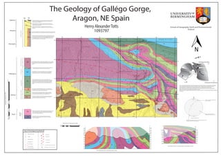
  • 1. 48 85 88 58 61 5752 50 42 40 50 3237 52 57 42 41 52 21 58 65 87 36 49 453182 41 72 84 88 81 57 06 03 05 12 4223 05 35 30 08 18 20 21 21 16 27 58 21 26 27 42 86 59 43 72 60 56 48 32 39 48 38 45 46 62 21 29 19 35 41 32 52 38 05 03 4758 39 29 33 39 64 68 71 88 62 62 29 03 42 37 13 48 34 84 52 57 57 85 82 50 69 81 39 79 51 33 49 84 6151 78 21 32 40 51 50 62 75 64 51 52 72 64 45 34 41 37 51 47 37 40 85 81 13 56 SCg X’’ X’ X’ X’’ 500 600 700 800 900 1000 1100 1200 500 600 700 800 900 1000 1100 1200 The Geology of Gallégo Gorge, Aragon, NE Spain Henry AlexanderTotts 1093797 School of Geography, Earth and Environmental Science Map and Cross Sections Scale 1:10 000 0m 100m 200m 300m 400m 500m 1000m Cross section from X’to X’’, shown on map. Cross section is to scale Key of Geological Symbols 682 686685684683 688687 685684683682 688687686 692 692 693 694 695 695 694 693 Cleavage 57 Observed Boundary Inferred Boundary Thrust Fault Plane Reverse Fault Plane Strike-slip Fault Plane SCg SCg SCg SCg SCg SCg GA GA GCg FCg GCg FCg GCg FCg FCg FCg DLs DLs DLs DLs DLs DLs DLs KLs KLs KLs KLs KLs KLs KLs KLs KLs KLs CLs CLs CLs CLs CLs CLs CLs CLs UCLs UCLs UCLs UCLs UCLs UCLs UCLs UCLs UCLs UCLs UCLs RSS RSS RSS RSS GLs GLs GLs GM GM GM GM GM GM SDS SDS USs USs USs SDS 200 300 400 500 600 700 800 900 1000 1100 1200 1300 200 300 400 500 600 700 800 900 1000 1100 1200 1300 Y’ Y’’ Cross section from Y’to Y’’on the map. Drawn to scale. GM GM GM FCg SDS TM TM RSS UCLs UCLs UCLs SDS CLs CLsCLs Overturned Antiform Showing Way Up of the Synform in Cross Section DLs KLs Ls UCLs RSS GLs GM TM SDS FCg USs SCg GAQuaternary Tertiary Tertiary Cretaceous Triassic Muschelkalk andKeuper FormtionsUncastilloFormationCampodarbeFormaitonArguisFormationGarumnFormationUpperCreatceousFormation GCg 0m100m200m300m400m500m1000m StratigraphicChartScale1:5000 57 Bedding Strike and Dip N Compression from North Compression from North East GM TM KLs KLs KLs DLs GLs RSS RSS UCLs CLs KLs DLs DLs DLs DLs DLs KLs KLs KLs CLs CLs UCLs UCLs RSS GLs This is an illustrated interpretation, showing the oblique nature of the thrusting. The image explains the folding of the comparitively shallow thrust fault seen towards the north. The figure above also illustrates how the compressional forces resulted in the non-cylindrical fold structure, at Pardina de Carcavilla, to form. Some of the structures not illustrated in the image are in the south east area of the map. The thrusting of the duplex structure is due to the compressive forces from the east. This means that the varying direction of the primary compression results in an overall sinistray strike-slip component to the area. 13 Plunge of Fold Axial Plane and Plunge Azimuth Synform Fold Axis Antiform Fold Axis Overturned Synform Muschelkalk Formation. Very dark, partially dolomitised limestone which has characteristics suggesting some Barrovian metamorphism. Possibly once fossiliferous. Keuper Formation. Variable composition, pale yellow and siliciclastic in areas as a Feldspar Greywacke. Lower Keuper Formation has more fine and micritic areas, which are darker coloured. The textural classification of the darker areas is a matrix supported wackestone. C This member is classified as a dirty micritic limestone, but is non-uniform composition, with areas of much larger calcitic crystals. Some flecks of quartz and clay nodules suggest terrestrial input. Very fine, musterd coloured sugary limestone. Fossiliferous, classified as a bio-micrite. Textural classification is a matrix supported wackestone. Very well preserved, large branching corals in isolated outcrops. Red member of interbedded sandstone and shale. Less compitent than surrounding limestones, so ductile deformation seen. Red colour indicative of oxidation, showing a high amount of terrestrial input. The Guara Limestone Member, is a medium-coarse dark limestone. Very consolidated, resistant to erosion, so forms large ridges. Identifiable through fossil content, namely Nummulites and Alveolines. Classified as a packstone. Turns to a siliciclastic rich bio-micrite throughout deposition. Is the primary constituant of the clasts supporting the red fanglomerate towers. Grey MarlMember, a very fine, quite fossiliferous marl. Good preservation potential seen by some of the recovered bivalves. Very unconsolidated, succeptable to severe erosion. Fissility expressed along bedding plane. Transitional Marl Formation, grain supported, so classified as a packstone. Expresses a change from shallow marine to fluvial environment. Santo Domingo Sandstone. Fluvial deposition, braided river system. Contains both sand and shale. Mostly a medium-coarse grained, brown to grey coloured fluvial sandstone. The main outcropping member of the large, overturned synform. Fanglomerate. Red coloured conglomerate with clast sized ranging from 5cm to over 1 meter. Clasts are mainly formed of the Guara Limestone Member, deposited as alluvial fans into a fluvial system. The most identifiable features of the area, very consolidated. Matrix is fine, calcitic in places. Palaeoflow readings show radial flow, but trending in a southernly direction. Grey Conglomerate Member. More eroded than the fanglomerates, with much smaller clast sizes. Formed from a less consolidated limestone, but still an alluvial fan system. Uncastillo Sandstone Member is syndepositional with the alluvial fans. Medium to coarse grained and conglomeratic in areas from post depositional reworking. SCg GA Sandy Conglomerates are Quaternary fluvial reworking of the Uncastillo Sandstone Member. Very abundant, and are made of clasts of the USs, with a medium to coarse grained matrix. Glacial Alluvium Member, showing where areas of the Uncastillo Sandstone Member have been glacially influenced post deposition. Rock powder is primary evidence, incredibly fine. 2 Stereonet of the folded beds at X’. Bedding is dipping steeply in a N direction. Not anomalous because the inner beds of the fold are overturned, therefore dipping north. Pole showing the synformal fold axis’ plunge and plunge azimuth, at 122 26 Great circle showing line of best fit through the poles to bedding. N Y’ Y’’ Palaeogene Neogene Palaeogene EmbalsedelaPena Pardina de Carcavilla Riglos