The document presents a study on the development of a physical parameter extraction model utilizing remote sensing data for flood detection and monitoring. It discusses methods of identifying flooded areas through the analysis of optical imagery, particularly using MODIS and Landsat data, while outlining the significance of various reflectance and index parameters in detecting floodwaters. The findings indicate that MODIS optical images can effectively identify flood-affected regions based on selected spectral characteristics.
![Development of Physical Parameter….
||Issn 2250-3005 || ||September||2013|| Page 42
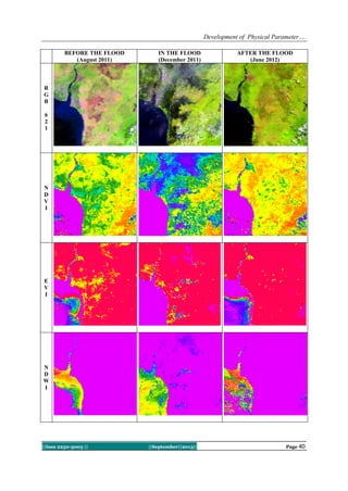
MNDWI, and DVEL.Based on the results of this study should be followed up with a more focused research,
namely by applying models based on physical parameters of MODIS imagery for identification of flood
inundation, particularly for rapid mapping purposes (rapid mapping) flood affected areas.
REFERENCES
[1]. Ayala, I.A., 2002. Geomorphology, natural hazards, vulnerability and prevention of natural disaster in developing countries.
Geomorphology, 47,107-124.
[2]. McFeeters, S. K., 1996. The use of the Normalized Difference Water Index (NDWI) in the delineation of open water features.
International Journal of Remote Sensing, 17(7), 1425-1432.
[3]. Huete, A., K. Didan, T. Miura, E.P. Rodriguez, X. Gao, & L.G. Ferreira, 2002. Overview of the radiometric and biophysical
performance of the MODIS vegetation indices, Remote Sensing of Environment, 83, 195–213.
[4]. Ho, L.T.K., Umitsu, M., & Yamaguchi, Y., 2010. Flood hazard mapping by satellite images and SRTM DEM in the Vu Gia-Thu
Bon Alluvial Plain, Central Vitenam. International Archieve of the Photogrammetry, Remote Sensing and Spatial Information
Science, 38(8), 275-280.
[5]. Islam, A.K.., Bala, S.K., & Haque, A., 2009. Flood inundation map of Bangladesh using MODIS surface reflectance. 2th
International Conference on Water & Flood Management (ICWFM-2009.
[6]. Richard, B.D., 1955. Flood Estimation and Control, Ed-3. Chapman & Hall Ltd., London.
[7]. Sakamoto, T., Cao, P.V., Nguyen, N.V., Kotera, A., & Yokozawa, M., 2009. Agro-ecological interpretation of rice cropping
systems in flood-prone areas using MODIS imagery. Photogrammetric Engineering & Remote Sensing, 75(4), 413–424.
[8]. Sudaryoko, Y., 1987. Pedoman Penanggulangan Banjir. Badan Penerbit Pekerjaan Umum, Jakarta.
[9]. Wang, Y., Colby, J.D., & Mulcahy, K.A.., 2002. An efficient method for mapping flood extent in a coastal floodplain using
Landsat TM and DEM data. International Journal of Remote sensing, 23(18), 3681-3696.
[10]. Yan, Y.E., Ouyang, Z.T., Guo, H.Q., Jin, S.S., & Zhao, B., 2010. Detecting the spatiotemporal changes of tidal flood in the
estuarine wetland by using MODIS time series data. Journal of Hydrology, 384, 156–163.
[11]. Xu, H., 2006. Modification of normalised difference water index (NDWI) to enhance open water features in remotely sensed
imagery. International Journal of Remote sensing, 27(14), 3025-3033.](https://image.slidesharecdn.com/f0392035042-131004063116-phpapp01/85/ijcer-8-320.jpg)


![Getting Started with Apache Spark: Big Data Made Simple [Free Meetup]](https://cdn.slidesharecdn.com/ss_thumbnails/apachesparkgettingstarted-260203175547-8361bcc3-thumbnail.jpg?width=640&height=640&fit=bounds)


