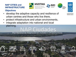
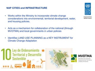
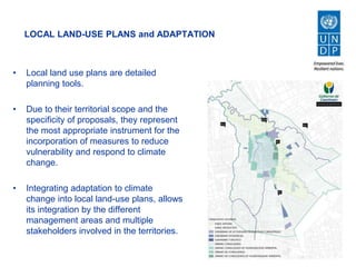
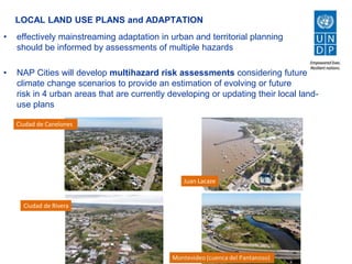
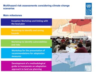
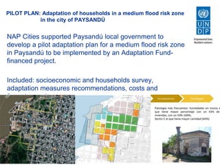
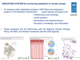
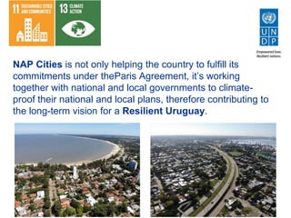
Experience from URUGUAY: NAP Cities and Infrastructure
WEBINAR
Linking National and Sub-national Adaptation: Vertical
integration in National Adaptation Plan (NAP) processes
United Nations Development Programme
URUGUAY
Land area: 175.016 km2
Coastline: 680 Km
Population: 3.380.177 people
93% in urban areas and 70% in coastal zones
Recent years: more frequent and intense floods, droughts and storms
Adaptation commitments in the NDC include:
NAP Cities and Infrastructure (2020)
NAP Coastal (2020)
NAP Agriculture (2020)
NAP Energy (2025)
NAP Health (2025)
NAP CITIES and
INFRASTRUCTURE
Objectives
• develop the adaptive capacity and resilience of
urban centres and those who live there,
• protect infrastructure and urban environments,
• integrate adaptation into national and local
planning.
NAP CITIES and INFRASTRUCTURE
• Works within the Ministry to incorporate climate change
considerations into environmental, territorial development, water,
and housing policies.
• Acts as a mechanism for collaboration of the national (through
MVOTMA) and local governments in urban policies
• Identifies LAND USE PLANNING as a KEY INSTRUMENT for
Climate Change Adaptation
LOCAL LAND-USE PLANS and ADAPTATION
• Local land use plans are detailed
planning tools.
• Due to their territorial scope and the
specificity of proposals, they represent
the most appropriate instrument for the
incorporation of measures to reduce
vulnerability and respond to climate
change.
• Integrating adaptation to climate
change into local land-use plans, allows
its integration by the different
management areas and multiple
stakeholders involved in the territories.
LOCAL LAND USE PLANS and ADAPTATION
• effectively mainstreaming adaptation in urban and territorial planning
should be informed by assessments of multiple hazards
• NAP Cities will develop multihazard risk assessments considering future
climate change scenarios to provide an estimation of evolving or future
risk in 4 urban areas that are currently developing or updating their local land-
use plans
Ciudad de Canelones
Ciudad de Rivera
Multihazard risk assessments considering climate change
scenarios
Main milestones
Workshop to identify vulnerabilities
and risks
Workshop for the presentation of
recommendations for adaptation
measures
Development of a methodological guide to
incorporate an adaptation approach to land use
planning
Workshop to identify and zoning
threats
Inception Workshop and links with the
local plan
Workshop to identify vulnerabilities
and risks
Workshop for the presentation of
recommendations for adaptation
measures
Development of a methodological
guide to incorporate an adaptation
approach to land use planning
Workshop to identify and zoning
hazards
Inception Workshop and linking with
the local plan
PILOT PLAN: Adaptation of households in a medium flood risk zone
in the city of PAYSANDÚ
NAP Cities supported Paysandú local government to
develop a pilot adaptation plan for a medium flood risk zone
in Paysandú to be implemented by an Adaptation Fund-
financed project.
Included: socioeconomic and households survey,
adaptation measures recommendations, costs and
financing options.
INDICATORS SYSTEM for monitoring adaptation to climate change
• To measure urban adaptation progress, NAP-Cities has designed a
system of 25 indicators 5 dimensions: - public spaces and green soil;
- infrastructure and buildings;
- social systems;
- governance and responsiveness;
- education, knowledge, and information.
• These indicators link the NAP-Cities with the National Climate Change
Policy, the NDC, the Sendai Framework and the 2030 Agenda.
NAP Cities is not only helping the country to fulfill its
commitments under theParis Agreement, it’s working
together with national and local governments to climate-
proof their national and local plans, therefore contributing to
the long-term vision for a Resilient Uruguay.
THANK YOU MUCHAS GRACIAS
Magdalena Preve
magdalena.preve@undp.org

Experience from Uruguay: NAP Cities and Infrastructure

  • 1.
    Experience from URUGUAY:NAP Cities and Infrastructure WEBINAR Linking National and Sub-national Adaptation: Vertical integration in National Adaptation Plan (NAP) processes United Nations Development Programme
  • 2.
    URUGUAY Land area: 175.016km2 Coastline: 680 Km Population: 3.380.177 people 93% in urban areas and 70% in coastal zones Recent years: more frequent and intense floods, droughts and storms
  • 3.
    Adaptation commitments inthe NDC include: NAP Cities and Infrastructure (2020) NAP Coastal (2020) NAP Agriculture (2020) NAP Energy (2025) NAP Health (2025)
  • 4.
    NAP CITIES and INFRASTRUCTURE Objectives •develop the adaptive capacity and resilience of urban centres and those who live there, • protect infrastructure and urban environments, • integrate adaptation into national and local planning.
  • 5.
    NAP CITIES andINFRASTRUCTURE • Works within the Ministry to incorporate climate change considerations into environmental, territorial development, water, and housing policies. • Acts as a mechanism for collaboration of the national (through MVOTMA) and local governments in urban policies • Identifies LAND USE PLANNING as a KEY INSTRUMENT for Climate Change Adaptation
  • 6.
    LOCAL LAND-USE PLANSand ADAPTATION • Local land use plans are detailed planning tools. • Due to their territorial scope and the specificity of proposals, they represent the most appropriate instrument for the incorporation of measures to reduce vulnerability and respond to climate change. • Integrating adaptation to climate change into local land-use plans, allows its integration by the different management areas and multiple stakeholders involved in the territories.
  • 7.
    LOCAL LAND USEPLANS and ADAPTATION • effectively mainstreaming adaptation in urban and territorial planning should be informed by assessments of multiple hazards • NAP Cities will develop multihazard risk assessments considering future climate change scenarios to provide an estimation of evolving or future risk in 4 urban areas that are currently developing or updating their local land- use plans Ciudad de Canelones Ciudad de Rivera
  • 8.
    Multihazard risk assessmentsconsidering climate change scenarios Main milestones Workshop to identify vulnerabilities and risks Workshop for the presentation of recommendations for adaptation measures Development of a methodological guide to incorporate an adaptation approach to land use planning Workshop to identify and zoning threats Inception Workshop and links with the local plan Workshop to identify vulnerabilities and risks Workshop for the presentation of recommendations for adaptation measures Development of a methodological guide to incorporate an adaptation approach to land use planning Workshop to identify and zoning hazards Inception Workshop and linking with the local plan
  • 9.
    PILOT PLAN: Adaptationof households in a medium flood risk zone in the city of PAYSANDÚ NAP Cities supported Paysandú local government to develop a pilot adaptation plan for a medium flood risk zone in Paysandú to be implemented by an Adaptation Fund- financed project. Included: socioeconomic and households survey, adaptation measures recommendations, costs and financing options.
  • 10.
    INDICATORS SYSTEM formonitoring adaptation to climate change • To measure urban adaptation progress, NAP-Cities has designed a system of 25 indicators 5 dimensions: - public spaces and green soil; - infrastructure and buildings; - social systems; - governance and responsiveness; - education, knowledge, and information. • These indicators link the NAP-Cities with the National Climate Change Policy, the NDC, the Sendai Framework and the 2030 Agenda.
  • 11.
    NAP Cities isnot only helping the country to fulfill its commitments under theParis Agreement, it’s working together with national and local governments to climate- proof their national and local plans, therefore contributing to the long-term vision for a Resilient Uruguay.
  • 12.
    THANK YOU MUCHASGRACIAS Magdalena Preve magdalena.preve@undp.org

Editor's Notes

  • #3 If you wish, you could speak about this a bit in the previous slide
  • #5 You could mention those when presenting the next slide
  • #10 I would also just introduce land use planning when talking abou t the next slides