Europe Maps 1914
•Download as PPT, PDF•
2 likes•15,257 views

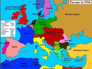
The 1914 Political Map of Europe shows the political boundaries and divisions of European states on the eve of World War I. Major powers included Germany, Austria-Hungary, Britain, France, Italy, and the Russian Empire. Several smaller states such as Serbia, Romania, and the Ottoman Empire occupied the Balkan region of southeastern Europe.
Report
Share
Report
Share

Recommended
Martin cooper paloma
Martin Marty Cooper was born in 1928 in Chicago. He graduated from Illinois Institute of Technology in 1950 with a degree in electrical engineering and later earned his master's degree. Cooper is considered the "father of the cell phone" as he invented the first handheld mobile phone in 1973 while working for Motorola and led the team that developed and commercialized it in 1983. Now aged 91, Cooper remains active as the co-founder and chairman of communications companies.
Napoleon Bonaparte
Napoleon Bonaparte through his upbringing, the Napoleonic Wars, and his effect on European economics and politics.
Napoleon Bonaparte
Napoleon Bonaparte was a French military and political leader who rose to prominence during the French Revolution. He led successful campaigns against enemies of the Revolution and established the French Empire, though he faced opposition from royalists and Jacobins. Napoleon instituted reforms in France including the education system, tax code, and infrastructure. He was married twice, first to Josephine and then to Marie Louise of Austria, and had one son. After a series of military victories and defeats, Napoleon was finally defeated at the Battle of Waterloo in 1815 and died in exile on the island of Saint Helena in 1821.
Bloody Mary
The document discusses Queen Mary I of England, also known as "Bloody Mary", as a representative of the Tudor dynasty. It provides background on Mary's lineage as the daughter of Henry VIII and Catherine of Aragon. It describes Mary's religious policy of reintroducing Catholicism upon taking the throne in 1553 and persecuting Protestants, executing over 300 during her reign. The document also gives context on the religious changes occurring in 16th century England between Catholicism and Protestantism.
Charles I
1) Charles I became King of England in 1625 after the death of his father, King James I.
2) Charles I faced opposition from the Puritan party when he became king. The Puritans were more extreme Protestants within the Church of England.
3) The English Civil War broke out as the Puritans wanted more balanced power between the King and Parliament, while Charles I believed in the divine right of kings. The war was fought between the Royalists who supported the King and the Parliamentarians who supported Parliament led by Oliver Cromwell.
French Absolutism
Henry IV brought stability to France after the Wars of Religion through the Edict of Nantes, which granted Huguenots religious tolerance. He reformed the government and increased the power of the monarchy, laying the foundations for absolutism. Under the guidance of Cardinals Richelieu and Mazarin, Louis XIII and Louis XIV further strengthened the monarch's control over the nobility and established absolutism, with Louis XIV proclaiming "L'état, c'est moi." Louis XIV expanded the bureaucracy, built up the army, revoked the Edict of Nantes, and was a patron of the arts, but his revocation damaged France's economy and reputation.
Charlemagne
Charlemagne was the first emperor of the Holy Roman Empire. He conquered much of Western and Central Europe during his reign between 768-814 AD. He converted many people in Europe to Christianity, helping to unite them under one religion. Charlemagne also reorganized the Holy Roman Empire into a more efficient political entity and helped restore economic prosperity through infrastructure projects. He established himself as emperor in 800 AD after being crowned by the pope on Christmas Day in Rome.
Bloody Mary
Mary I, also known as Bloody Mary, was queen of England from 1553 to 1558. She was the daughter of King Henry VIII and Catherine of Aragon. When she took the throne, Mary tried to return England to Roman Catholicism after her Protestant brother Edward's reign, executing over 280 Protestants who refused to convert. Her five-year reign ended with her death in 1558, during which time she married King Phillip II of Spain and faced challenges to her rule from Lady Jane Grey.
Hundred years war
The Hundred Years' War between England and France consisted of three phases from 1337 to 1453. The Edwardian phase saw English victories at battles like Crecy, Calais, and Poitiers led by Edward III and the Black Prince. The Caroline phase involved conflicts in Brittany and Spain. The final Lancastrian phase began with an English win at Agincourt but saw the tide turn with French victories at Patay and Formigny and the Siege of Orleans led by Joan of Arc, culminating in the final French victory at Castillon.
The Habsburgs - Unit 7
The document provides details about the Habsburg dynasty in Spain, including Charles I and Philip II. It can be summarized as follows:
Charles I inherited a vast empire through marriage alliances, including territories in Spain, the Netherlands, Austria, and Italy. He faced many internal revolts during his rule due to his inexperience and favoritism toward Flemish advisers. Externally, he battled France and the Ottoman Empire for control of territories. He abdicated in 1556, leaving Spain and other territories to his son Philip II.
Philip II established a highly centralized and authoritarian monarchy in Spain. He focused on expanding royal power at the expense of representative bodies like the Cortes. Relig
The Hundred Years War
The document provides background information on the Hundred Years War between France and England from 1337 to 1453. It summarizes key events such as the Norman Conquest establishing English claims to French lands, early English victories at battles like Crecy and Agincourt through the use of the longbow and cannons, and the rise of Joan of Arc who helped rally French forces and lift the English siege of Orleans, shifting momentum back to France.
Martin luther and the reformation
Martin Luther was troubled by the Catholic Church's practice of selling indulgences to forgive sins and fund the rebuilding of St. Peter's Basilica in Rome. In 1517, he wrote the 95 Theses criticizing indulgences and questioning papal authority. He nailed the theses to the door of the Wittenberg Castle church to debate fellow scholars. This sparked the Protestant Reformation as his ideas spread through printing and divided Western Christianity into Catholic and Protestant branches that still exist today.
England in 17th century-Glorious revolution
Elizabeth I was succeeded by her cousin James VI of Scotland, who became James I of England, uniting the kingdoms of England, Scotland, and Ireland under a single monarch for the first time. James I's son Charles I ruled as an absolute monarch and repeatedly clashed with Parliament over taxes and religious reforms, culminating in the English Civil War between Royalist Cavaliers and Parliamentarian Roundheads. Charles I was defeated, tried for treason, and executed in 1649. Oliver Cromwell then ruled as Lord Protector during the Interregnum period until the monarchy was restored in 1660 with Charles II. However, Charles II's Catholic brother James II took the throne in 1685 and his pro-Catholic policies
Charlemagne
This document provides background information on vocabulary terms related to the Middle Ages such as medieval, monastery, monks, Benedict, and Charlemagne. It discusses how Christianity spread across Europe through missionaries and monks living in monasteries. It describes Benedict creating rules for monks and Charlemagne conquering territory to build a large empire and being crowned emperor. It notes Charlemagne's accomplishments in improving education by building schools and bringing scholars to teach.
La europa de la restauración
La Europa de la Restauración (1815-1848) se caracterizó por el restablecimiento del Antiguo Régimen y el equilibrio de poder entre las grandes potencias luego del Congreso de Viena. Sin embargo, con el tiempo surgieron oleadas revolucionarias que llevaron a la transición hacia gobiernos constitucionales y la unificación de Italia y Alemania.
Oliver cromwell-the dark horse
this is the ppt on Oliver Cromwell a british who played an important role during the civil war in Britain.
Prins Laurent, rebel met een reden - Thierry Debels
Wie is prins Laurent echt? Auteur Thierry Debels ging op zoek naar het enfant terrible van de koninklijke familie van België.
The Hundred Years War
A series of wars between the French House of Valois and the English House of Plantagenet erupted from 1337-1453 over the French throne. The wars saw victories on both sides, with the English initially gaining ground under Edward III and Henry V, while Joan of Arc helped rally the French to push the English back. The final French victory at Castillon in 1453 marked the end of the Hundred Years' War and English control of French lands, except for Calais.
Charlemagne
Charlemagne became the ruler of the Franks in 771 after his brother's death. He sought to expand his empire through military conquest and forced Christianity on his subjects. In 800, Pope Leo III crowned Charlemagne as the first Holy Roman Emperor, granting him authority over much of Western Europe. As emperor, Charlemagne issued decrees on both church and state matters and promoted education, inviting scholars to his court to further spread Christianity and classical learning.
Archduke Franz Ferdinand
Archduke Franz Ferdinand was the heir to the Austro-Hungarian throne who was assassinated in 1914 in Sarajevo by Gavrilo Princip, a member of the secret society called the Black Hand. Ferdinand had decided to visit Sarajevo despite warnings, and while riding in a car with his wife, their driver took a wrong turn and stopped near where Princip was waiting. Princip shot and killed Ferdinand and his wife, sparking conflict between Austria-Hungary and Serbia that escalated into World War I as other European powers took sides in the dispute.
Elizabeth i
Elizabeth I was queen of England from 1558 until her death in 1603. During her 45-year reign, she transformed England into a strong Protestant nation and established itself as a major power on the world stage through naval victories over Spain. Her defeat of the Spanish Armada in 1588 secured England's position as the dominant naval power and established its identity as a sovereign state. Elizabeth also presided over the English Renaissance and fostered the growth of arts and literature during her reign, with playwrights like Shakespeare producing great works. She remained beloved by the English people for restoring stability and prosperity to the nation.
Powerpoint charlemagne
Charlemagne was a Frankish king who was crowned Holy Roman Emperor in 800 CE. He led successful military campaigns to expand his empire and spread Christianity. Through counts, missi dominici, and unifying church and state, Charlemagne brought stability and reforms including standardized currency, infrastructure projects, and promoting education, arts, and religion. After his death, his empire was divided under the Treaty of Verdun.
The spanish empire
The Spanish Empire was one of the largest empires in world history. At its peak during the 16th century under the Habsburgs, Spain controlled vast territories in Europe and the Americas. However, the empire declined over subsequent centuries due to costly wars and Spain's loss of European dominance. By the early 19th century, most of Spain's American colonies had gained independence following the Napoleonic occupation of Spain.
Anne frank-timeline-worksheet
Anne Frank was born in Germany in 1929 and moved with her family to the Netherlands in 1933 to escape Nazi persecution. In 1942, after Germany occupied the Netherlands, Anne and her family went into hiding in an annex of a building in Amsterdam. While in hiding from 1942 to 1944, Anne received a diary for her 13th birthday which she wrote in regularly, documenting the family's time in hiding. The diary provides one of the most famous first-hand accounts of the experiences of Jews during the Holocaust. Anne and her sister ultimately died at the Bergen-Belsen concentration camp in 1945.
Hitler Project
Adolf Hitler was born in 1889 in Austria and showed early academic promise but was rejected from art school twice. He joined the German Workers' Party in 1919 and helped transform it into the Nazi Party. As leader he rose to power in 1933 becoming Chancellor of Germany and established a fascist dictatorship. He abolished democracy and made the Nazi Party the only legal party. Hitler pursued aggressive expansionist policies, invading countries in Europe and sparking World War II. He committed suicide in 1945 as Allied forces advanced on Berlin and Germany surrendered, ending his regime.
Henry hudson
Henry Hudson was an English explorer born in London in the 1560s who made multiple voyages trying to find the Northwest Passage to Asia for England and the Netherlands. During his fourth voyage while searching for the passage, Hudson explored what is now known as Hudson Bay, Strait, and River before his crew mutinied and left him there in 1611, never to be seen again.
Absolute Monarchs Of Europe
1. Philip II inherited Spain, the Spanish Netherlands, and the American colonies after his father Charles V retired. Between 1550-1650, Spain imported over $14 billion worth of gold and silver from the Americas, allowing Philip II to become Spain's absolute monarch.
2. Louis XIV ruled France from 1643-1715, the longest reign of any European monarch. He weakened the nobility and increased the power of government officials to strengthen his absolute rule. He spent lavishly on Versailles to surround himself with luxury.
3. Ivan IV of Russia became czar at age 16 and ruled as an absolute monarch, but grew increasingly paranoid and violent, ordering thousands of nobles and others executed. He was succeeded
Numbers 1-4, Still at Mount Sinai, Arithmoi, Numbers, wilderness miḏbar, cler...
Numbers 1-4, Still at Mount Sinai, Arithmoi, Numbers, wilderness miḏbar, cler...Valley Bible Fellowship
Numbers Chapters 1-4, Still at Mount Sinai, Arithmoi, Numbers, wilderness miḏbar, clergy priests, 14 names 12 tribes, Standards, Banners22 The Tabernacle
God instructed Moses to build a sanctuary called the tabernacle so that God could dwell among the Israelites. The tabernacle consisted of an outer sanctuary and an inner most holy place separated by a veil. Only the high priest could enter the most holy place once a year on Yom Kippur with blood sacrifices to atone for sins. The tabernacle and its furnishings, including the ark of the covenant, were built according to God's precise instructions. The tabernacle services involved animal sacrifices on the altar, which pointed to the need for blood atonement but did not ultimately take away sins.
More Related Content
What's hot
Hundred years war
The Hundred Years' War between England and France consisted of three phases from 1337 to 1453. The Edwardian phase saw English victories at battles like Crecy, Calais, and Poitiers led by Edward III and the Black Prince. The Caroline phase involved conflicts in Brittany and Spain. The final Lancastrian phase began with an English win at Agincourt but saw the tide turn with French victories at Patay and Formigny and the Siege of Orleans led by Joan of Arc, culminating in the final French victory at Castillon.
The Habsburgs - Unit 7
The document provides details about the Habsburg dynasty in Spain, including Charles I and Philip II. It can be summarized as follows:
Charles I inherited a vast empire through marriage alliances, including territories in Spain, the Netherlands, Austria, and Italy. He faced many internal revolts during his rule due to his inexperience and favoritism toward Flemish advisers. Externally, he battled France and the Ottoman Empire for control of territories. He abdicated in 1556, leaving Spain and other territories to his son Philip II.
Philip II established a highly centralized and authoritarian monarchy in Spain. He focused on expanding royal power at the expense of representative bodies like the Cortes. Relig
The Hundred Years War
The document provides background information on the Hundred Years War between France and England from 1337 to 1453. It summarizes key events such as the Norman Conquest establishing English claims to French lands, early English victories at battles like Crecy and Agincourt through the use of the longbow and cannons, and the rise of Joan of Arc who helped rally French forces and lift the English siege of Orleans, shifting momentum back to France.
Martin luther and the reformation
Martin Luther was troubled by the Catholic Church's practice of selling indulgences to forgive sins and fund the rebuilding of St. Peter's Basilica in Rome. In 1517, he wrote the 95 Theses criticizing indulgences and questioning papal authority. He nailed the theses to the door of the Wittenberg Castle church to debate fellow scholars. This sparked the Protestant Reformation as his ideas spread through printing and divided Western Christianity into Catholic and Protestant branches that still exist today.
England in 17th century-Glorious revolution
Elizabeth I was succeeded by her cousin James VI of Scotland, who became James I of England, uniting the kingdoms of England, Scotland, and Ireland under a single monarch for the first time. James I's son Charles I ruled as an absolute monarch and repeatedly clashed with Parliament over taxes and religious reforms, culminating in the English Civil War between Royalist Cavaliers and Parliamentarian Roundheads. Charles I was defeated, tried for treason, and executed in 1649. Oliver Cromwell then ruled as Lord Protector during the Interregnum period until the monarchy was restored in 1660 with Charles II. However, Charles II's Catholic brother James II took the throne in 1685 and his pro-Catholic policies
Charlemagne
This document provides background information on vocabulary terms related to the Middle Ages such as medieval, monastery, monks, Benedict, and Charlemagne. It discusses how Christianity spread across Europe through missionaries and monks living in monasteries. It describes Benedict creating rules for monks and Charlemagne conquering territory to build a large empire and being crowned emperor. It notes Charlemagne's accomplishments in improving education by building schools and bringing scholars to teach.
La europa de la restauración
La Europa de la Restauración (1815-1848) se caracterizó por el restablecimiento del Antiguo Régimen y el equilibrio de poder entre las grandes potencias luego del Congreso de Viena. Sin embargo, con el tiempo surgieron oleadas revolucionarias que llevaron a la transición hacia gobiernos constitucionales y la unificación de Italia y Alemania.
Oliver cromwell-the dark horse
this is the ppt on Oliver Cromwell a british who played an important role during the civil war in Britain.
Prins Laurent, rebel met een reden - Thierry Debels
Wie is prins Laurent echt? Auteur Thierry Debels ging op zoek naar het enfant terrible van de koninklijke familie van België.
The Hundred Years War
A series of wars between the French House of Valois and the English House of Plantagenet erupted from 1337-1453 over the French throne. The wars saw victories on both sides, with the English initially gaining ground under Edward III and Henry V, while Joan of Arc helped rally the French to push the English back. The final French victory at Castillon in 1453 marked the end of the Hundred Years' War and English control of French lands, except for Calais.
Charlemagne
Charlemagne became the ruler of the Franks in 771 after his brother's death. He sought to expand his empire through military conquest and forced Christianity on his subjects. In 800, Pope Leo III crowned Charlemagne as the first Holy Roman Emperor, granting him authority over much of Western Europe. As emperor, Charlemagne issued decrees on both church and state matters and promoted education, inviting scholars to his court to further spread Christianity and classical learning.
Archduke Franz Ferdinand
Archduke Franz Ferdinand was the heir to the Austro-Hungarian throne who was assassinated in 1914 in Sarajevo by Gavrilo Princip, a member of the secret society called the Black Hand. Ferdinand had decided to visit Sarajevo despite warnings, and while riding in a car with his wife, their driver took a wrong turn and stopped near where Princip was waiting. Princip shot and killed Ferdinand and his wife, sparking conflict between Austria-Hungary and Serbia that escalated into World War I as other European powers took sides in the dispute.
Elizabeth i
Elizabeth I was queen of England from 1558 until her death in 1603. During her 45-year reign, she transformed England into a strong Protestant nation and established itself as a major power on the world stage through naval victories over Spain. Her defeat of the Spanish Armada in 1588 secured England's position as the dominant naval power and established its identity as a sovereign state. Elizabeth also presided over the English Renaissance and fostered the growth of arts and literature during her reign, with playwrights like Shakespeare producing great works. She remained beloved by the English people for restoring stability and prosperity to the nation.
Powerpoint charlemagne
Charlemagne was a Frankish king who was crowned Holy Roman Emperor in 800 CE. He led successful military campaigns to expand his empire and spread Christianity. Through counts, missi dominici, and unifying church and state, Charlemagne brought stability and reforms including standardized currency, infrastructure projects, and promoting education, arts, and religion. After his death, his empire was divided under the Treaty of Verdun.
The spanish empire
The Spanish Empire was one of the largest empires in world history. At its peak during the 16th century under the Habsburgs, Spain controlled vast territories in Europe and the Americas. However, the empire declined over subsequent centuries due to costly wars and Spain's loss of European dominance. By the early 19th century, most of Spain's American colonies had gained independence following the Napoleonic occupation of Spain.
Anne frank-timeline-worksheet
Anne Frank was born in Germany in 1929 and moved with her family to the Netherlands in 1933 to escape Nazi persecution. In 1942, after Germany occupied the Netherlands, Anne and her family went into hiding in an annex of a building in Amsterdam. While in hiding from 1942 to 1944, Anne received a diary for her 13th birthday which she wrote in regularly, documenting the family's time in hiding. The diary provides one of the most famous first-hand accounts of the experiences of Jews during the Holocaust. Anne and her sister ultimately died at the Bergen-Belsen concentration camp in 1945.
Hitler Project
Adolf Hitler was born in 1889 in Austria and showed early academic promise but was rejected from art school twice. He joined the German Workers' Party in 1919 and helped transform it into the Nazi Party. As leader he rose to power in 1933 becoming Chancellor of Germany and established a fascist dictatorship. He abolished democracy and made the Nazi Party the only legal party. Hitler pursued aggressive expansionist policies, invading countries in Europe and sparking World War II. He committed suicide in 1945 as Allied forces advanced on Berlin and Germany surrendered, ending his regime.
Henry hudson
Henry Hudson was an English explorer born in London in the 1560s who made multiple voyages trying to find the Northwest Passage to Asia for England and the Netherlands. During his fourth voyage while searching for the passage, Hudson explored what is now known as Hudson Bay, Strait, and River before his crew mutinied and left him there in 1611, never to be seen again.
Absolute Monarchs Of Europe
1. Philip II inherited Spain, the Spanish Netherlands, and the American colonies after his father Charles V retired. Between 1550-1650, Spain imported over $14 billion worth of gold and silver from the Americas, allowing Philip II to become Spain's absolute monarch.
2. Louis XIV ruled France from 1643-1715, the longest reign of any European monarch. He weakened the nobility and increased the power of government officials to strengthen his absolute rule. He spent lavishly on Versailles to surround himself with luxury.
3. Ivan IV of Russia became czar at age 16 and ruled as an absolute monarch, but grew increasingly paranoid and violent, ordering thousands of nobles and others executed. He was succeeded
What's hot (20)
Prins Laurent, rebel met een reden - Thierry Debels
Prins Laurent, rebel met een reden - Thierry Debels
Viewers also liked
Numbers 1-4, Still at Mount Sinai, Arithmoi, Numbers, wilderness miḏbar, cler...
Numbers 1-4, Still at Mount Sinai, Arithmoi, Numbers, wilderness miḏbar, cler...Valley Bible Fellowship
Numbers Chapters 1-4, Still at Mount Sinai, Arithmoi, Numbers, wilderness miḏbar, clergy priests, 14 names 12 tribes, Standards, Banners22 The Tabernacle
God instructed Moses to build a sanctuary called the tabernacle so that God could dwell among the Israelites. The tabernacle consisted of an outer sanctuary and an inner most holy place separated by a veil. Only the high priest could enter the most holy place once a year on Yom Kippur with blood sacrifices to atone for sins. The tabernacle and its furnishings, including the ark of the covenant, were built according to God's precise instructions. The tabernacle services involved animal sacrifices on the altar, which pointed to the need for blood atonement but did not ultimately take away sins.
Putting History on the Map with Calisphere - CCSS 2011
Presented at the California Council for the Social Studies annual conference March 4, 2011. Presented by Sherri Berger, California Digital Library, and Letty Kraus, UC Davis History Project.
Philosophy - The Nature of the State - Government control
The document discusses the different sectors of government control. It describes the general government sector and its four subsectors: central government, state government, local government, and social security funds. Central government governs an entire nation. State government makes laws for a particular state. Local government administers towns, cities, counties. Social security funds involve compulsory contributions and government-determined benefits. It also describes the public non-financial corporations sector and public financial corporations sector, which are engaged in producing goods/services and involve roles of government in the economy respectively.
Representation of the Earth: Maps
There are different types of maps that represent geographic information in various ways. Physical maps illustrate terrain features like mountains and rivers. Political maps show national borders and cities. Economic maps represent natural resources and industries. Climate maps provide climate and precipitation data. Road maps are used for planning trips as they show roads, cities, and other transportation details. When representing the spherical Earth on a flat map, areas and distances become distorted.
Concept Map
The Industrial Revolution began in England in the mid-1700s. England had factors like fertile land from new farming methods, surplus labor from increased food production, and strong banking from overseas trade that enabled industrialization. Key industries transformed were agriculture through enclosed farming and crop rotation, factory production bringing higher employment and urban migration, and transportation through inventions like the steam engine and locomotives improving infrastructure. Overall, these changes boosted the economy by allowing for more efficient, cheaper production and transportation of goods.
TIME's Person of the Year, from 1927 to 2014
TIME's Person of the Year is an annual designation given by TIME magazine to the person or group of people who had the greatest influence on news events of the year. Some of the notable Persons of the Year include Charles Lindbergh in 1927, Adolf Hitler in 1938, Winston Churchill in 1940, and The Ebola Fighters in 2014 which included doctors, nurses and caregivers who worked to combat the deadly Ebola virus outbreak in West Africa.
Political map of europe answers
The political map of Europe shows the locations of 8 countries - Belgium, France, Germany, Italy, Poland, Russia, Ukraine, and the United Kingdom. Russia is located in eastern Europe. Poland and Ukraine are located east of Germany. The United Kingdom, Belgium, France, Germany, Italy and Spain are all located in western Europe.
Life cycle qf human
The document outlines the key stages of human life: baby, toddler, child, teenager, and adult. It was written by Rahaf Gareeb, a 5th grade student in class A, and addressed to Miss Hessa Al-Shammari.
Hierarchy and Functions of Local Government
Local governments are led by elected councils which provide services to their communities. Councils are made up of a mayor/chairperson and 6-21 councillors who are elected every 4 years. They oversee services like recreation, libraries, roads, and waste management. Council meetings are held monthly for decisions to be made. Local governments fund and support activities that improve their communities.
My Great Indian Prime Ministers
This document lists the Prime Ministers of India from Jawaharlal Nehru in 1947 to Dr. Manmohan Singh currently, providing their names, terms in office, and brief interim positions. It traces the leadership of the country over several decades through changes in government.
Indian government central government
Its about Indian Government for IGCSE/CBSE, Grade 8 students.
Reach me at http://brinsmith.blogspot.in
Tabernacle Presentation 2003 Ppt Version Update 2010recorded
The document outlines God's plan of salvation as revealed through various passages in the books of Exodus and Numbers. It describes how God called Moses to lead the Israelites out of Egypt, established a covenant with them at Mount Sinai, and instructed Moses to build the Tabernacle as a place where God could dwell among his people. Key events mentioned include the Israelites worshipping the golden calf, God providing instructions for sacrifices and priestly duties, and the significance of the Tabernacle furnishings pointing to Jesus as the fulfillment of God's salvation plan.
Functions of local government
Local governments in Pakistan function at the grassroots level and are formed by people in a locality to address local problems and basic needs. They include local committees, coordination committees, district councils, and provincial development advisory councils. Local committees are elected by villages or town districts and are responsible for organizing local services like roads, sanitation, and safety. District councils take the general outlines from higher councils and adapt them to local circumstances to outline local policies for their area. The functions of local governments include both compulsory functions related to public services as well as optional functions.
TABERNACLE
The document describes the tabernacle that was constructed by Moses in the wilderness based on divine instructions. It summarizes the various components of the tabernacle including the ark of the covenant, table of showbread, lampstand, altars, and veil. It explains that the tabernacle and its instruments foreshadowed spiritual truths about Jesus Christ, his incarnation, and the church. The camp of Israel was arranged with the tabernacle at the center, and the document outlines the order and placement of the tribes' encampments.
Urban local self government
This document provides an overview of urban local self-government in India with a focus on Andhra Pradesh. It discusses the evolution of municipalities in India and their constitutional status. The key points are:
1. Municipal bodies have a long history in India dating back to the 17th century.
2. The 74th amendment to the Indian constitution provides for three types of municipalities - Nagar Panchayats for transitional areas, Municipal Councils for smaller urban areas, and Municipal Corporations for larger cities.
3. Andhra Pradesh has 124 urban local bodies including 16 municipal corporations and 102 municipalities. Their composition, functions, finances and authorities are described.
Map Reading
This document provides an overview of key elements of map reading including:
1. The main components of a map including title, scale, legend, grid lines, and north arrows.
2. Grid systems and references for locating positions on a map.
3. How to determine distances and directions using map scales, bearings, and cardinal points.
4. Methods for identifying one's own location including resection and using known lines/features.
5. Techniques for locating other positions including intersection and using azimuth and distance.
World time zones
The document discusses time zones around the world, noting that Greenwich, England is located at 0 degrees longitude and is used to measure time from, with time zones adding or subtracting one hour for every 15 degrees east or west; it explains that international date line follows the 180th meridian and results in a one day difference when crossing it west to east; and time zone boundaries sometimes adjust slightly within countries to avoid confusion by keeping entire states or provinces within the same time zone.
Panchayat System in India
The document discusses India's Panchayati Raj system of local self-government. It describes how the system provides for three levels of local administration: village, taluk, and district. At the village level, the Gram Panchayat is responsible for activities like health, sanitation, education, and village industries. Above the village level are the Taluk Panchayat and Zilla Panchayat, which handle administrative functions over larger areas. The document also discusses municipal local bodies in cities and towns, including municipalities and municipal corporations.
Viewers also liked (20)
Numbers 1-4, Still at Mount Sinai, Arithmoi, Numbers, wilderness miḏbar, cler...
Numbers 1-4, Still at Mount Sinai, Arithmoi, Numbers, wilderness miḏbar, cler...
Putting History on the Map with Calisphere - CCSS 2011
Putting History on the Map with Calisphere - CCSS 2011
Philosophy - The Nature of the State - Government control
Philosophy - The Nature of the State - Government control
Tabernacle Presentation 2003 Ppt Version Update 2010recorded
Tabernacle Presentation 2003 Ppt Version Update 2010recorded
More from Kelli Brooke
Persuasive ppt
This document discusses various propaganda and advertising techniques used to persuade people. It defines techniques like bandwagon, testimonials, loaded words, card stacking, misuse of statistics, plain folks, name calling, snob appeal, slogans, and targeting audiences. Examples are provided for many techniques to illustrate how they work, such as using a celebrity testimonial or appealing to people's desire to be part of the majority. The goal of these techniques is to make people want to buy a product or agree with a viewpoint using emotional rather than factual appeals.
Active reader
Active readers use several strategies to get the most out of what they read. They preview the text by looking at titles, pictures, and summaries to make predictions. As they read, they check their predictions and look for the main idea and key details to support it. They also connect new information to what they already know. Active readers skim to get the general meaning and read more slowly to understand and remember details. Summarizing is important to check comprehension. Using strategies like SQ3R helps readers be engaged and get the full meaning from texts.
Active reader
This document provides tips for being an active reader such as previewing the text by looking at titles, pictures, and summaries to make predictions about what will be discussed. It recommends identifying the main idea and key details that support it by finding who, what, when, where, why, and how details. The document also suggests using SQ3R (survey, question, read, recite, review) as a strategy for actively reading and comprehending a text.
Priorities
The document uses a metaphor of filling a jar with rocks, pebbles, and water to illustrate the importance of prioritizing tasks. Rocks represent essential priorities that must be completed each day, like school, chores, and sleep. Pebbles are enjoyable activities one wants more time for, like hobbies and socializing. Water is optional activities that are nice to do if there is time. The metaphor teaches that by completing essential rocks first, one makes room for more pebbles and water activities in their daily schedule.
Locker Organization
The document provides tips for organizing one's school locker. It recommends (1) memorizing your locker combination using a rhyme, (2) cleaning out the locker monthly and removing dirty clothes, (3) not storing food which can attract pests, (4) using shelves, toolboxes, and dry erase boards to separate and store items neatly, and (5) keeping books and notebooks organized by class period. An organized locker makes it easy to find materials and supports being prepared for each school day.
Rules and procedures
This document outlines the classroom rules, procedures, and expectations for Mrs. Howard's class. It details things such as: being on time, having required materials, completing daily cursive work, procedures for turning in assignments, getting help or using the bathroom/sharpening a pencil, and how students will be dismissed. It also explains the behavior punch card system where students can earn rewards for following rules each month.
Many Types of Intelligence
This document discusses the many types of intelligence and provides examples of careers suited for each type. It identifies nine types of intelligence: body smart, music smart, word smart, number/reason smart, picture smart, people smart, self smart, nature smart. For each type, it provides a brief description of traits and examples of three potential careers that suit those strengths and interests.
Ms Zapatistas 1234910198472590 1use
The Zapatistas are a group of indigenous Mexicans who have fought for improved rights and living conditions for indigenous people in Chiapas, Mexico since the 1990s. They employ guerrilla warfare tactics against the Mexican government to protest poverty, inequality, and trade policies they believe hurt indigenous farmers. Chiapas is resource-rich but many indigenous people live in poverty, inspiring the Zapatistas' armed uprisings and ongoing protests against NAFTA and other policies they argue do not benefit local communities.
Ms Zapatistas 1234910198472590 1use
The Zapatistas are a group of indigenous Mexicans who have fought for improved rights and living conditions for indigenous people in Chiapas, Mexico since the 1990s. They employ guerrilla warfare tactics against the Mexican government to protest poverty, inequality, and trade policies they believe hurt indigenous farmers. Chiapas is resource-rich but many indigenous people live in poverty, inspiring the Zapatistas' armed uprisings and ongoing activism to demand more assistance and autonomy for indigenous communities in Chiapas.
La Geo 2
Latin America refers to the regions of Mexico, Central America, South America, and the Caribbean islands where Spanish and Portuguese are predominantly spoken. The climate varies from tropical in Central America to temperate in southern South America and northern Mexico. Seasons are reversed in the Southern Hemisphere. Major physical features include the Andes Mountains, Sierra Madre Mountains, Caribbean islands, Galapagos Islands, and rainforests like the Amazon. Coastal deserts like the Atacama in Chile form due to the rain shadow effect of the Andes blocking moisture. Rivers include the Amazon, and physical geography has impacted population patterns with urbanization along coasts and formation of megacities.
La Maps
Types of maps include physical maps that show permanent geographic features, climate maps that show long-term weather averages, natural resource maps that identify valuable natural resources, and population density maps that measure the number of people per square mile by dividing total population by land area.
La Location
The Andes Mountains in Peru and the Amazon Rainforest in Brazil are two distinct geographic locations. The Andes Mountains are a mountain range located in western South America, while the Amazon Rainforest is the largest rainforest in the world, located mostly in northern Brazil. The climate, terrain, and wildlife found in the Andes Mountains differ greatly from that within the Amazon Rainforest.
Geography Of Latin America
This document provides a brief overview of the geography of Latin America, dividing it into three main regions - Mexico, Central America, and South America. It lists the countries located in Central America between Mexico and South America, as well as some of the major geographic features found in Latin America, including mountain ranges, rivers, deserts, and seas bordering the region.
Europe Aims Of The Eu
The European Union aims to promote economic and social progress for its citizens, establish a unified international presence, introduce European citizenship with rights for EU citizens, develop the region as an area of freedom, security and justice, and maintain and build upon existing EU laws that protect peoples' rights in member countries.
Comparing The Economies Of The United Kingdom,
The document compares the economies of the United Kingdom, Germany, and Russia. In the UK and Germany, businesses and farms are primarily owned by private citizens and corporations who also decide production levels based on supply and demand. It is very easy to start a business in these countries, taking only days. In contrast, the Russian government owns most businesses and farms, and controls many large businesses, influencing production and prices. Starting a business in Russia is also more time consuming, taking months.
Gov Uk Ger Russ
The document compares the governments of the UK, Germany, and Russia. It summarizes that the UK has a unitary parliamentary democracy with a constitutional monarchy, where the prime minister holds more power than the monarch. Germany is a federal parliamentary democracy where the chancellor holds more power than the president. Russia is a federal semi-presidential democracy where the president holds more power than the prime minister. All three countries allow citizens over 18 to vote.
Government Participation
This document discusses three forms of government: autocracy, where a single person rules with unlimited power; oligarchy, where a small group holds power; and democracy, where all citizens hold power. Democracy is defined as a system where the government receives its power from all people.
Government Power
There are three main types of government: unitary, confederation, and federal. In a unitary government, all power is centralized in one central government that makes laws and decisions for the people. A confederation is a loose alliance where individual states make their own laws and have a weak central government. A federal government shares power between a central government and states, with both levels having some self-rule and ability to make laws.
Europe Major Religions In Europe
This document summarizes and compares the three major monotheistic religions in Europe: Christianity, Judaism, and Islam. It outlines their core beliefs and practices, including their views of God, holy books, places of worship, founders, and traditions. Christianity believes in one God and that Jesus Christ is his son. Judaism's central figure is Abraham and they worship on Saturday. Islam was founded by Muhammad and holds Friday as its holy day of prayer.
Russianrevolution 090917074457 Phpapp01
The document summarizes the events leading up to the Russian Revolution. It describes how the Russian people suffered under the absolute rule of Czar Nicholas II, including poor living conditions for serfs. Dissatisfaction grew due to losses in the Russo-Japanese War and World War I, causing food shortages and unrest. In early 1917, widespread riots broke out and the weak provisional government that replaced the czar failed to stabilize Russia. This created an opening for Vladimir Lenin and the Bolsheviks to take control and establish a communist Soviet Union.
More from Kelli Brooke (20)
Recently uploaded
BBR 2024 Summer Sessions Interview Training
Qualitative research interview training by Professor Katrina Pritchard and Dr Helen Williams
LAND USE LAND COVER AND NDVI OF MIRZAPUR DISTRICT, UP
This Dissertation explores the particular circumstances of Mirzapur, a region located in the
core of India. Mirzapur, with its varied terrains and abundant biodiversity, offers an optimal
environment for investigating the changes in vegetation cover dynamics. Our study utilizes
advanced technologies such as GIS (Geographic Information Systems) and Remote sensing to
analyze the transformations that have taken place over the course of a decade.
The complex relationship between human activities and the environment has been the focus
of extensive research and worry. As the global community grapples with swift urbanization,
population expansion, and economic progress, the effects on natural ecosystems are becoming
more evident. A crucial element of this impact is the alteration of vegetation cover, which plays a
significant role in maintaining the ecological equilibrium of our planet.Land serves as the foundation for all human activities and provides the necessary materials for
these activities. As the most crucial natural resource, its utilization by humans results in different
'Land uses,' which are determined by both human activities and the physical characteristics of the
land.
The utilization of land is impacted by human needs and environmental factors. In countries
like India, rapid population growth and the emphasis on extensive resource exploitation can lead
to significant land degradation, adversely affecting the region's land cover.
Therefore, human intervention has significantly influenced land use patterns over many
centuries, evolving its structure over time and space. In the present era, these changes have
accelerated due to factors such as agriculture and urbanization. Information regarding land use and
cover is essential for various planning and management tasks related to the Earth's surface,
providing crucial environmental data for scientific, resource management, policy purposes, and
diverse human activities.
Accurate understanding of land use and cover is imperative for the development planning
of any area. Consequently, a wide range of professionals, including earth system scientists, land
and water managers, and urban planners, are interested in obtaining data on land use and cover
changes, conversion trends, and other related patterns. The spatial dimensions of land use and
cover support policymakers and scientists in making well-informed decisions, as alterations in
these patterns indicate shifts in economic and social conditions. Monitoring such changes with the
help of Advanced technologies like Remote Sensing and Geographic Information Systems is
crucial for coordinated efforts across different administrative levels. Advanced technologies like
Remote Sensing and Geographic Information Systems
9
Changes in vegetation cover refer to variations in the distribution, composition, and overall
structure of plant communities across different temporal and spatial scales. These changes can
occur natural.
Gender and Mental Health - Counselling and Family Therapy Applications and In...
A proprietary approach developed by bringing together the best of learning theories from Psychology, design principles from the world of visualization, and pedagogical methods from over a decade of training experience, that enables you to: Learn better, faster!
Main Java[All of the Base Concepts}.docx
This is part 1 of my Java Learning Journey. This Contains Custom methods, classes, constructors, packages, multithreading , try- catch block, finally block and more.
Beyond Degrees - Empowering the Workforce in the Context of Skills-First.pptx
Iván Bornacelly, Policy Analyst at the OECD Centre for Skills, OECD, presents at the webinar 'Tackling job market gaps with a skills-first approach' on 12 June 2024
Your Skill Boost Masterclass: Strategies for Effective Upskilling
Your Skill Boost Masterclass: Strategies for Effective UpskillingExcellence Foundation for South Sudan
Strategies for Effective Upskilling is a presentation by Chinwendu Peace in a Your Skill Boost Masterclass organisation by the Excellence Foundation for South Sudan on 08th and 09th June 2024 from 1 PM to 3 PM on each day.BÀI TẬP BỔ TRỢ TIẾNG ANH 8 CẢ NĂM - GLOBAL SUCCESS - NĂM HỌC 2023-2024 (CÓ FI...
BÀI TẬP BỔ TRỢ TIẾNG ANH 8 CẢ NĂM - GLOBAL SUCCESS - NĂM HỌC 2023-2024 (CÓ FI...Nguyen Thanh Tu Collection
https://app.box.com/s/y977uz6bpd3af4qsebv7r9b7s21935vdConstructing Your Course Container for Effective Communication
Communicating effectively and consistently with students can help them feel at ease during their learning experience and provide the instructor with a communication trail to track the course's progress. This workshop will take you through constructing an engaging course container to facilitate effective communication.
Temple of Asclepius in Thrace. Excavation results
The temple and the sanctuary around were dedicated to Asklepios Zmidrenus. This name has been known since 1875 when an inscription dedicated to him was discovered in Rome. The inscription is dated in 227 AD and was left by soldiers originating from the city of Philippopolis (modern Plovdiv).
Traditional Musical Instruments of Arunachal Pradesh and Uttar Pradesh - RAYH...
Traditional Musical Instruments of Arunachal Pradesh and Uttar Pradesh
বাংলাদেশ অর্থনৈতিক সমীক্ষা (Economic Review) ২০২৪ UJS App.pdf
বাংলাদেশের অর্থনৈতিক সমীক্ষা ২০২৪ [Bangladesh Economic Review 2024 Bangla.pdf] কম্পিউটার , ট্যাব ও স্মার্ট ফোন ভার্সন সহ সম্পূর্ণ বাংলা ই-বুক বা pdf বই " সুচিপত্র ...বুকমার্ক মেনু 🔖 ও হাইপার লিংক মেনু 📝👆 যুক্ত ..
আমাদের সবার জন্য খুব খুব গুরুত্বপূর্ণ একটি বই ..বিসিএস, ব্যাংক, ইউনিভার্সিটি ভর্তি ও যে কোন প্রতিযোগিতা মূলক পরীক্ষার জন্য এর খুব ইম্পরট্যান্ট একটি বিষয় ...তাছাড়া বাংলাদেশের সাম্প্রতিক যে কোন ডাটা বা তথ্য এই বইতে পাবেন ...
তাই একজন নাগরিক হিসাবে এই তথ্য গুলো আপনার জানা প্রয়োজন ...।
বিসিএস ও ব্যাংক এর লিখিত পরীক্ষা ...+এছাড়া মাধ্যমিক ও উচ্চমাধ্যমিকের স্টুডেন্টদের জন্য অনেক কাজে আসবে ...
Advanced Java[Extra Concepts, Not Difficult].docx
This is part 2 of my Java Learning Journey. This contains Hashing, ArrayList, LinkedList, Date and Time Classes, Calendar Class and more.
How to Make a Field Mandatory in Odoo 17
In Odoo, making a field required can be done through both Python code and XML views. When you set the required attribute to True in Python code, it makes the field required across all views where it's used. Conversely, when you set the required attribute in XML views, it makes the field required only in the context of that particular view.
ANATOMY AND BIOMECHANICS OF HIP JOINT.pdf
it describes the bony anatomy including the femoral head , acetabulum, labrum . also discusses the capsule , ligaments . muscle that act on the hip joint and the range of motion are outlined. factors affecting hip joint stability and weight transmission through the joint are summarized.
Solutons Maths Escape Room Spatial .pptx
Solutions of Puzzles of Mathematics Escape Room Game in Spatial.io
How to Setup Warehouse & Location in Odoo 17 Inventory
In this slide, we'll explore how to set up warehouses and locations in Odoo 17 Inventory. This will help us manage our stock effectively, track inventory levels, and streamline warehouse operations.
Recently uploaded (20)
LAND USE LAND COVER AND NDVI OF MIRZAPUR DISTRICT, UP
LAND USE LAND COVER AND NDVI OF MIRZAPUR DISTRICT, UP
Gender and Mental Health - Counselling and Family Therapy Applications and In...
Gender and Mental Health - Counselling and Family Therapy Applications and In...
Beyond Degrees - Empowering the Workforce in the Context of Skills-First.pptx
Beyond Degrees - Empowering the Workforce in the Context of Skills-First.pptx
Your Skill Boost Masterclass: Strategies for Effective Upskilling
Your Skill Boost Masterclass: Strategies for Effective Upskilling
NEWSPAPERS - QUESTION 1 - REVISION POWERPOINT.pptx
NEWSPAPERS - QUESTION 1 - REVISION POWERPOINT.pptx
BÀI TẬP BỔ TRỢ TIẾNG ANH 8 CẢ NĂM - GLOBAL SUCCESS - NĂM HỌC 2023-2024 (CÓ FI...
BÀI TẬP BỔ TRỢ TIẾNG ANH 8 CẢ NĂM - GLOBAL SUCCESS - NĂM HỌC 2023-2024 (CÓ FI...
Constructing Your Course Container for Effective Communication
Constructing Your Course Container for Effective Communication
Traditional Musical Instruments of Arunachal Pradesh and Uttar Pradesh - RAYH...
Traditional Musical Instruments of Arunachal Pradesh and Uttar Pradesh - RAYH...
বাংলাদেশ অর্থনৈতিক সমীক্ষা (Economic Review) ২০২৪ UJS App.pdf
বাংলাদেশ অর্থনৈতিক সমীক্ষা (Economic Review) ২০২৪ UJS App.pdf
Film vocab for eal 3 students: Australia the movie
Film vocab for eal 3 students: Australia the movie
How to Setup Warehouse & Location in Odoo 17 Inventory
How to Setup Warehouse & Location in Odoo 17 Inventory
Europe Maps 1914
- 3. 1914 Political Map of Europe