SlideShare a Scribd company logo
Esri Geoportal Server
             ®


Aggregate geospatial resources for improved
discovery, use, and collaboration.

Esri® Geoportal Server is an open source product that
enables discovery and use of geospatial resources includ-
ing datasets, rasters, and web services. It helps organiza-
tions manage and publish metadata for their geospatial
resources so users can discover and connect to those
resources. Geoportal Server supports standards-based
clearinghouse and metadata discovery applications.

Geoportal Server was released under the Apache™ 2.0
license, which allows developers to freely customize and
redistribute the software.

With the Geoportal Server, you can

Reduce time and redundancy of data production by
connecting geospatial data and service producers with
consumers.
                                                              The look and feel of Esri Geoportal Server is highly customizable.
Maintain data integrity by allowing organizations to easily
share the authoritative version of data among its users.

Enable easy search and discovery of existing geospatial
data and services by allowing users to create and manage
descriptions of their geospatial resources and supporting
easy-to-use, sophisticated data discovery technologies.


For more information about
Esri Geoportal Server visit                                   NOAA’s (National Oceanic and Atmospheric Administration) National
                                                              Climatic Data Center (NCDC) built its geoportal to provide access
esri.com/geoportal.                                           to many forms of geospatial data, including dynamic mapping
                                                              applications and OGC® Web services.
Key Features of Esri Geoportal Server
Esri Geoportal Server helps you build and administer a
geoportal Web site where data producers can register their
geospatial resources for users to discover and consume.

The Esri Geoportal Server

• Supports international data and technology standards,
  such as ISO, OGC, FGDC, INSPIRE, and W3C®
• Catalogs existing GIS resources regardless of location
  or type
• Facilitates discovery of GIS resources with the
  customizable geoportal web interface
• Integrates with ArcGIS® Desktop and ArcGIS Explorer
  Desktop and Flex™ and Silverlight ® Web maps
• Synchronizes content from other catalogs and                                                                                                   The Geoportal of Lombardy connects the geospatial data from the
  geoportals                                                                                                                                     region’s many organizations in one central location.

• Supports REST, GeoRSS, OpenSearch, GeoJSON, KML,
  and HTML to expose content from the catalog service to
  external clients
• Integrates with third-party content management
  systems, portal frameworks, and authentication systems

Open Options with Open Source
The free open source model for Geoportal Server makes it
easy for you to use and customize multiple geoportals. You
can deploy a geoportal for

• Personal geospatial data management to aggregate
  your local datasets and public or enterprise services to
  manage and browse all your resources in one location
• Collaboration with other departments and                                                                                                       The New York State Department of Environmental Conservation uses
                                                                                                                                                 the Geoportal Server to share its data with the public and among its
  organizations for general or project-specific data sharing
                                                                                                                                                 various divisions and bureaus.
• Enterprise geospatial data management to manage all
  your organization’s geospatial resources in one location
• Communication with the public via the geoportal’s
  intuitive Web interface


                                                                                                                                                 For more information about
                                                                                                                                                 Esri Geoportal Server visit
                                                                                                                                                 esri.com/geoportal.
Copyright © 2012 Esri. All rights reserved. Esri, the Esri globe logo, ArcGIS, and esri.com are trademarks, service marks, or registered marks of Esri in the United States, the European Community, or certain other jurisdictions. Other companies and products or services mentioned
herein may be trademarks, service marks, or registered marks of their respective mark owners.

130678 ESRI.25C5/12kp

More Related Content

Viewers also liked

Keek friend follower
Keek friend followerKeek friend follower
Keek friend followerpeter963
 
Hym for the weekend - Coldplay and Beyonce
Hym for the weekend - Coldplay and BeyonceHym for the weekend - Coldplay and Beyonce
Hym for the weekend - Coldplay and Beyonce
Mess Lod
 
Galería peu denuncian torturas
Galería peu denuncian torturasGalería peu denuncian torturas
Galería peu denuncian torturas
Crónicas del despojo
 
61 1224 señores, quisieramos ver a jesús
61 1224 señores, quisieramos ver a jesús61 1224 señores, quisieramos ver a jesús
61 1224 señores, quisieramos ver a jesús
Miguel Angel Huayta Seminario
 
Clase 19 roles modificada
Clase 19 roles   modificadaClase 19 roles   modificada
Clase 19 roles modificada
Titiushko Jazz
 
Keek funding
Keek fundingKeek funding
Keek fundingpeter963
 
Trabajo de Informática Médica
Trabajo de Informática MédicaTrabajo de Informática Médica
Trabajo de Informática Médica
Alexandra Melendrez
 
Keek for andtoid
Keek for andtoidKeek for andtoid
Keek for andtoidpeter963
 
Bottle masks
Bottle masksBottle masks
Bottle masks
Neus Marí Tur
 
Happiness advantage
Happiness advantageHappiness advantage
Happiness advantage
jdg5213
 
Unidad 3 Grupos Sanguineos
Unidad 3 Grupos SanguineosUnidad 3 Grupos Sanguineos
Unidad 3 Grupos Sanguineos
Leonardo Hernandez
 

Viewers also liked (12)

Keek friend follower
Keek friend followerKeek friend follower
Keek friend follower
 
Hym for the weekend - Coldplay and Beyonce
Hym for the weekend - Coldplay and BeyonceHym for the weekend - Coldplay and Beyonce
Hym for the weekend - Coldplay and Beyonce
 
Galería peu denuncian torturas
Galería peu denuncian torturasGalería peu denuncian torturas
Galería peu denuncian torturas
 
61 1224 señores, quisieramos ver a jesús
61 1224 señores, quisieramos ver a jesús61 1224 señores, quisieramos ver a jesús
61 1224 señores, quisieramos ver a jesús
 
Clase 19 roles modificada
Clase 19 roles   modificadaClase 19 roles   modificada
Clase 19 roles modificada
 
Keek funding
Keek fundingKeek funding
Keek funding
 
Trabajo de Informática Médica
Trabajo de Informática MédicaTrabajo de Informática Médica
Trabajo de Informática Médica
 
Keek for andtoid
Keek for andtoidKeek for andtoid
Keek for andtoid
 
25c7 -2
 25c7 -2 25c7 -2
25c7 -2
 
Bottle masks
Bottle masksBottle masks
Bottle masks
 
Happiness advantage
Happiness advantageHappiness advantage
Happiness advantage
 
Unidad 3 Grupos Sanguineos
Unidad 3 Grupos SanguineosUnidad 3 Grupos Sanguineos
Unidad 3 Grupos Sanguineos
 

Similar to Esri Geoportal Server

Esri Geoportal Server
Esri Geoportal ServerEsri Geoportal Server
Esri Geoportal Server
Esri
 
Esri Geoportal Server
Esri Geoportal ServerEsri Geoportal Server
Esri Geoportal Server
Esri
 
Data Sharing and Collaboration
Data Sharing and CollaborationData Sharing and Collaboration
Data Sharing and Collaboration
Marten Hogeweg
 
Enrichment of Geoportal Interoperable Platform and Development of Thematic Ap...
Enrichment of Geoportal Interoperable Platform and Development of Thematic Ap...Enrichment of Geoportal Interoperable Platform and Development of Thematic Ap...
Enrichment of Geoportal Interoperable Platform and Development of Thematic Ap...
IRJET Journal
 
Geonetwork for Spatial Data
Geonetwork for Spatial DataGeonetwork for Spatial Data
Geonetwork for Spatial Data
Nizam GIS
 
Situational awareness
Situational awarenessSituational awareness
Situational awareness
Sergei Seleznev
 
Syntactic and semantic based approaches for Geoinformation Management - Dr. S...
Syntactic and semantic based approaches for Geoinformation Management - Dr. S...Syntactic and semantic based approaches for Geoinformation Management - Dr. S...
Syntactic and semantic based approaches for Geoinformation Management - Dr. S...
NeGD Capacity Building
 
Esri-Supported OGC/ISO Standards
Esri-Supported OGC/ISO StandardsEsri-Supported OGC/ISO Standards
Esri-Supported OGC/ISO Standards
Esri
 
Geospatial Metadata and Spatial Data: It's all Greek to me!
Geospatial Metadata and Spatial Data: It's all Greek to me!Geospatial Metadata and Spatial Data: It's all Greek to me!
Geospatial Metadata and Spatial Data: It's all Greek to me!
EDINA, University of Edinburgh
 
Esri News for Federal Government Winter 2012/2013 issue
Esri News for Federal Government Winter 2012/2013 issueEsri News for Federal Government Winter 2012/2013 issue
Esri News for Federal Government Winter 2012/2013 issue
Esri
 
ArcGIS
ArcGISArcGIS
ArcGIS
Esri
 
HoLIS GIS Update
HoLIS GIS UpdateHoLIS GIS Update
Portal for ArcGIS
Portal for ArcGISPortal for ArcGIS
Portal for ArcGIS
Esri
 
2015 FOSS4G Track: Open Specifications for the Storage, Transport and Process...
2015 FOSS4G Track: Open Specifications for the Storage, Transport and Process...2015 FOSS4G Track: Open Specifications for the Storage, Transport and Process...
2015 FOSS4G Track: Open Specifications for the Storage, Transport and Process...
GIS in the Rockies
 
Geospatial Ontologies and GeoSPARQL Services
Geospatial Ontologies and GeoSPARQL ServicesGeospatial Ontologies and GeoSPARQL Services
Geospatial Ontologies and GeoSPARQL Services
Stephane Fellah
 
Next Generation Open Data Platforms | AWS Public Sector Summit 2016
Next Generation Open Data Platforms | AWS Public Sector Summit 2016Next Generation Open Data Platforms | AWS Public Sector Summit 2016
Next Generation Open Data Platforms | AWS Public Sector Summit 2016
Amazon Web Services
 
Implementing an Open Source Spatiotemporal Search Platform for Spatial Data I...
Implementing an Open Source Spatiotemporal Search Platform for Spatial Data I...Implementing an Open Source Spatiotemporal Search Platform for Spatial Data I...
Implementing an Open Source Spatiotemporal Search Platform for Spatial Data I...
Paolo Corti
 
ArcGIS
ArcGISArcGIS
ArcGIS
Esri
 
Open Source GIS
Open Source GISOpen Source GIS
Open Source GIS
Joe Larson
 
Esri News for Petroleum Winter 2012/2013 newsletter
Esri News for Petroleum Winter 2012/2013 newsletterEsri News for Petroleum Winter 2012/2013 newsletter
Esri News for Petroleum Winter 2012/2013 newsletter
Esri
 

Similar to Esri Geoportal Server (20)

Esri Geoportal Server
Esri Geoportal ServerEsri Geoportal Server
Esri Geoportal Server
 
Esri Geoportal Server
Esri Geoportal ServerEsri Geoportal Server
Esri Geoportal Server
 
Data Sharing and Collaboration
Data Sharing and CollaborationData Sharing and Collaboration
Data Sharing and Collaboration
 
Enrichment of Geoportal Interoperable Platform and Development of Thematic Ap...
Enrichment of Geoportal Interoperable Platform and Development of Thematic Ap...Enrichment of Geoportal Interoperable Platform and Development of Thematic Ap...
Enrichment of Geoportal Interoperable Platform and Development of Thematic Ap...
 
Geonetwork for Spatial Data
Geonetwork for Spatial DataGeonetwork for Spatial Data
Geonetwork for Spatial Data
 
Situational awareness
Situational awarenessSituational awareness
Situational awareness
 
Syntactic and semantic based approaches for Geoinformation Management - Dr. S...
Syntactic and semantic based approaches for Geoinformation Management - Dr. S...Syntactic and semantic based approaches for Geoinformation Management - Dr. S...
Syntactic and semantic based approaches for Geoinformation Management - Dr. S...
 
Esri-Supported OGC/ISO Standards
Esri-Supported OGC/ISO StandardsEsri-Supported OGC/ISO Standards
Esri-Supported OGC/ISO Standards
 
Geospatial Metadata and Spatial Data: It's all Greek to me!
Geospatial Metadata and Spatial Data: It's all Greek to me!Geospatial Metadata and Spatial Data: It's all Greek to me!
Geospatial Metadata and Spatial Data: It's all Greek to me!
 
Esri News for Federal Government Winter 2012/2013 issue
Esri News for Federal Government Winter 2012/2013 issueEsri News for Federal Government Winter 2012/2013 issue
Esri News for Federal Government Winter 2012/2013 issue
 
ArcGIS
ArcGISArcGIS
ArcGIS
 
HoLIS GIS Update
HoLIS GIS UpdateHoLIS GIS Update
HoLIS GIS Update
 
Portal for ArcGIS
Portal for ArcGISPortal for ArcGIS
Portal for ArcGIS
 
2015 FOSS4G Track: Open Specifications for the Storage, Transport and Process...
2015 FOSS4G Track: Open Specifications for the Storage, Transport and Process...2015 FOSS4G Track: Open Specifications for the Storage, Transport and Process...
2015 FOSS4G Track: Open Specifications for the Storage, Transport and Process...
 
Geospatial Ontologies and GeoSPARQL Services
Geospatial Ontologies and GeoSPARQL ServicesGeospatial Ontologies and GeoSPARQL Services
Geospatial Ontologies and GeoSPARQL Services
 
Next Generation Open Data Platforms | AWS Public Sector Summit 2016
Next Generation Open Data Platforms | AWS Public Sector Summit 2016Next Generation Open Data Platforms | AWS Public Sector Summit 2016
Next Generation Open Data Platforms | AWS Public Sector Summit 2016
 
Implementing an Open Source Spatiotemporal Search Platform for Spatial Data I...
Implementing an Open Source Spatiotemporal Search Platform for Spatial Data I...Implementing an Open Source Spatiotemporal Search Platform for Spatial Data I...
Implementing an Open Source Spatiotemporal Search Platform for Spatial Data I...
 
ArcGIS
ArcGISArcGIS
ArcGIS
 
Open Source GIS
Open Source GISOpen Source GIS
Open Source GIS
 
Esri News for Petroleum Winter 2012/2013 newsletter
Esri News for Petroleum Winter 2012/2013 newsletterEsri News for Petroleum Winter 2012/2013 newsletter
Esri News for Petroleum Winter 2012/2013 newsletter
 

More from Esri

INIA- CISA: Análisis de las amenazas en la fauna silvestre
INIA- CISA: Análisis de las amenazas en la fauna silvestreINIA- CISA: Análisis de las amenazas en la fauna silvestre
INIA- CISA: Análisis de las amenazas en la fauna silvestre
Esri
 
Aena Aeropuerto Adolfo Suárez-Barajas crea potentes aplicaciones para sus cli...
Aena Aeropuerto Adolfo Suárez-Barajas crea potentes aplicaciones para sus cli...Aena Aeropuerto Adolfo Suárez-Barajas crea potentes aplicaciones para sus cli...
Aena Aeropuerto Adolfo Suárez-Barajas crea potentes aplicaciones para sus cli...
Esri
 
Plataforma Smart City de Móstoles
Plataforma Smart City de MóstolesPlataforma Smart City de Móstoles
Plataforma Smart City de Móstoles
Esri
 
ArcGIS Online para Organizaciones
ArcGIS Online para OrganizacionesArcGIS Online para Organizaciones
ArcGIS Online para Organizaciones
Esri
 
Molina de Segura se convierte en una smart city
Molina de Segura se convierte en una smart cityMolina de Segura se convierte en una smart city
Molina de Segura se convierte en una smart city
Esri
 
GIS-Based Web Services Provide Rapid Analysis and Dissemination of Maritime Data
GIS-Based Web Services Provide Rapid Analysis and Dissemination of Maritime DataGIS-Based Web Services Provide Rapid Analysis and Dissemination of Maritime Data
GIS-Based Web Services Provide Rapid Analysis and Dissemination of Maritime Data
Esri
 
An Effective Tool for Drinking Water Protection
An Effective Tool for Drinking Water ProtectionAn Effective Tool for Drinking Water Protection
An Effective Tool for Drinking Water Protection
Esri
 
GeoCollector for ArcPad
GeoCollector for ArcPadGeoCollector for ArcPad
GeoCollector for ArcPad
Esri
 
GeoCollector for ArcGIS for Windows Mobile
GeoCollector for ArcGIS for Windows MobileGeoCollector for ArcGIS for Windows Mobile
GeoCollector for ArcGIS for Windows Mobile
Esri
 
Data Appliance for ArcGIS
Data Appliance for ArcGISData Appliance for ArcGIS
Data Appliance for ArcGIS
Esri
 
Esri and BlackBridge
Esri and BlackBridgeEsri and BlackBridge
Esri and BlackBridge
Esri
 
GeoPlanner for ArcGIS
GeoPlanner for ArcGISGeoPlanner for ArcGIS
GeoPlanner for ArcGIS
Esri
 
Esri and AccuWeather
Esri and AccuWeatherEsri and AccuWeather
Esri and AccuWeather
Esri
 
Esri and Airbus Defense & Space
Esri and Airbus Defense & SpaceEsri and Airbus Defense & Space
Esri and Airbus Defense & Space
Esri
 
Esri US Data Fact Sheet
Esri US Data Fact SheetEsri US Data Fact Sheet
Esri US Data Fact Sheet
Esri
 
ArcGIS for Server on Microsoft Azure Jumpstart
ArcGIS for Server on Microsoft Azure JumpstartArcGIS for Server on Microsoft Azure Jumpstart
ArcGIS for Server on Microsoft Azure Jumpstart
Esri
 
ArcGIS for the Military--Maritime Operations
ArcGIS for the Military--Maritime OperationsArcGIS for the Military--Maritime Operations
ArcGIS for the Military--Maritime Operations
Esri
 
ArcGIS GeoEvent Extension for Server
ArcGIS GeoEvent Extension for ServerArcGIS GeoEvent Extension for Server
ArcGIS GeoEvent Extension for Server
Esri
 
The NATO Core Geographic Services System
The NATO Core Geographic Services SystemThe NATO Core Geographic Services System
The NATO Core Geographic Services System
Esri
 
ArcGIS for Desktop Tips and Shortcuts
ArcGIS for Desktop Tips and ShortcutsArcGIS for Desktop Tips and Shortcuts
ArcGIS for Desktop Tips and Shortcuts
Esri
 

More from Esri (20)

INIA- CISA: Análisis de las amenazas en la fauna silvestre
INIA- CISA: Análisis de las amenazas en la fauna silvestreINIA- CISA: Análisis de las amenazas en la fauna silvestre
INIA- CISA: Análisis de las amenazas en la fauna silvestre
 
Aena Aeropuerto Adolfo Suárez-Barajas crea potentes aplicaciones para sus cli...
Aena Aeropuerto Adolfo Suárez-Barajas crea potentes aplicaciones para sus cli...Aena Aeropuerto Adolfo Suárez-Barajas crea potentes aplicaciones para sus cli...
Aena Aeropuerto Adolfo Suárez-Barajas crea potentes aplicaciones para sus cli...
 
Plataforma Smart City de Móstoles
Plataforma Smart City de MóstolesPlataforma Smart City de Móstoles
Plataforma Smart City de Móstoles
 
ArcGIS Online para Organizaciones
ArcGIS Online para OrganizacionesArcGIS Online para Organizaciones
ArcGIS Online para Organizaciones
 
Molina de Segura se convierte en una smart city
Molina de Segura se convierte en una smart cityMolina de Segura se convierte en una smart city
Molina de Segura se convierte en una smart city
 
GIS-Based Web Services Provide Rapid Analysis and Dissemination of Maritime Data
GIS-Based Web Services Provide Rapid Analysis and Dissemination of Maritime DataGIS-Based Web Services Provide Rapid Analysis and Dissemination of Maritime Data
GIS-Based Web Services Provide Rapid Analysis and Dissemination of Maritime Data
 
An Effective Tool for Drinking Water Protection
An Effective Tool for Drinking Water ProtectionAn Effective Tool for Drinking Water Protection
An Effective Tool for Drinking Water Protection
 
GeoCollector for ArcPad
GeoCollector for ArcPadGeoCollector for ArcPad
GeoCollector for ArcPad
 
GeoCollector for ArcGIS for Windows Mobile
GeoCollector for ArcGIS for Windows MobileGeoCollector for ArcGIS for Windows Mobile
GeoCollector for ArcGIS for Windows Mobile
 
Data Appliance for ArcGIS
Data Appliance for ArcGISData Appliance for ArcGIS
Data Appliance for ArcGIS
 
Esri and BlackBridge
Esri and BlackBridgeEsri and BlackBridge
Esri and BlackBridge
 
GeoPlanner for ArcGIS
GeoPlanner for ArcGISGeoPlanner for ArcGIS
GeoPlanner for ArcGIS
 
Esri and AccuWeather
Esri and AccuWeatherEsri and AccuWeather
Esri and AccuWeather
 
Esri and Airbus Defense & Space
Esri and Airbus Defense & SpaceEsri and Airbus Defense & Space
Esri and Airbus Defense & Space
 
Esri US Data Fact Sheet
Esri US Data Fact SheetEsri US Data Fact Sheet
Esri US Data Fact Sheet
 
ArcGIS for Server on Microsoft Azure Jumpstart
ArcGIS for Server on Microsoft Azure JumpstartArcGIS for Server on Microsoft Azure Jumpstart
ArcGIS for Server on Microsoft Azure Jumpstart
 
ArcGIS for the Military--Maritime Operations
ArcGIS for the Military--Maritime OperationsArcGIS for the Military--Maritime Operations
ArcGIS for the Military--Maritime Operations
 
ArcGIS GeoEvent Extension for Server
ArcGIS GeoEvent Extension for ServerArcGIS GeoEvent Extension for Server
ArcGIS GeoEvent Extension for Server
 
The NATO Core Geographic Services System
The NATO Core Geographic Services SystemThe NATO Core Geographic Services System
The NATO Core Geographic Services System
 
ArcGIS for Desktop Tips and Shortcuts
ArcGIS for Desktop Tips and ShortcutsArcGIS for Desktop Tips and Shortcuts
ArcGIS for Desktop Tips and Shortcuts
 

Recently uploaded

How to Get CNIC Information System with Paksim Ga.pptx
How to Get CNIC Information System with Paksim Ga.pptxHow to Get CNIC Information System with Paksim Ga.pptx
How to Get CNIC Information System with Paksim Ga.pptx
danishmna97
 
PCI PIN Basics Webinar from the Controlcase Team
PCI PIN Basics Webinar from the Controlcase TeamPCI PIN Basics Webinar from the Controlcase Team
PCI PIN Basics Webinar from the Controlcase Team
ControlCase
 
UiPath Test Automation using UiPath Test Suite series, part 6
UiPath Test Automation using UiPath Test Suite series, part 6UiPath Test Automation using UiPath Test Suite series, part 6
UiPath Test Automation using UiPath Test Suite series, part 6
DianaGray10
 
Artificial Intelligence for XMLDevelopment
Artificial Intelligence for XMLDevelopmentArtificial Intelligence for XMLDevelopment
Artificial Intelligence for XMLDevelopment
Octavian Nadolu
 
Why You Should Replace Windows 11 with Nitrux Linux 3.5.0 for enhanced perfor...
Why You Should Replace Windows 11 with Nitrux Linux 3.5.0 for enhanced perfor...Why You Should Replace Windows 11 with Nitrux Linux 3.5.0 for enhanced perfor...
Why You Should Replace Windows 11 with Nitrux Linux 3.5.0 for enhanced perfor...
SOFTTECHHUB
 
GraphSummit Singapore | Graphing Success: Revolutionising Organisational Stru...
GraphSummit Singapore | Graphing Success: Revolutionising Organisational Stru...GraphSummit Singapore | Graphing Success: Revolutionising Organisational Stru...
GraphSummit Singapore | Graphing Success: Revolutionising Organisational Stru...
Neo4j
 
Large Language Model (LLM) and it’s Geospatial Applications
Large Language Model (LLM) and it’s Geospatial ApplicationsLarge Language Model (LLM) and it’s Geospatial Applications
Large Language Model (LLM) and it’s Geospatial Applications
Rohit Gautam
 
Video Streaming: Then, Now, and in the Future
Video Streaming: Then, Now, and in the FutureVideo Streaming: Then, Now, and in the Future
Video Streaming: Then, Now, and in the Future
Alpen-Adria-Universität
 
RESUME BUILDER APPLICATION Project for students
RESUME BUILDER APPLICATION Project for studentsRESUME BUILDER APPLICATION Project for students
RESUME BUILDER APPLICATION Project for students
KAMESHS29
 
Uni Systems Copilot event_05062024_C.Vlachos.pdf
Uni Systems Copilot event_05062024_C.Vlachos.pdfUni Systems Copilot event_05062024_C.Vlachos.pdf
Uni Systems Copilot event_05062024_C.Vlachos.pdf
Uni Systems S.M.S.A.
 
GraphSummit Singapore | Neo4j Product Vision & Roadmap - Q2 2024
GraphSummit Singapore | Neo4j Product Vision & Roadmap - Q2 2024GraphSummit Singapore | Neo4j Product Vision & Roadmap - Q2 2024
GraphSummit Singapore | Neo4j Product Vision & Roadmap - Q2 2024
Neo4j
 
Securing your Kubernetes cluster_ a step-by-step guide to success !
Securing your Kubernetes cluster_ a step-by-step guide to success !Securing your Kubernetes cluster_ a step-by-step guide to success !
Securing your Kubernetes cluster_ a step-by-step guide to success !
KatiaHIMEUR1
 
Cosa hanno in comune un mattoncino Lego e la backdoor XZ?
Cosa hanno in comune un mattoncino Lego e la backdoor XZ?Cosa hanno in comune un mattoncino Lego e la backdoor XZ?
Cosa hanno in comune un mattoncino Lego e la backdoor XZ?
Speck&Tech
 
Climate Impact of Software Testing at Nordic Testing Days
Climate Impact of Software Testing at Nordic Testing DaysClimate Impact of Software Testing at Nordic Testing Days
Climate Impact of Software Testing at Nordic Testing Days
Kari Kakkonen
 
“Building and Scaling AI Applications with the Nx AI Manager,” a Presentation...
“Building and Scaling AI Applications with the Nx AI Manager,” a Presentation...“Building and Scaling AI Applications with the Nx AI Manager,” a Presentation...
“Building and Scaling AI Applications with the Nx AI Manager,” a Presentation...
Edge AI and Vision Alliance
 
TrustArc Webinar - 2024 Global Privacy Survey
TrustArc Webinar - 2024 Global Privacy SurveyTrustArc Webinar - 2024 Global Privacy Survey
TrustArc Webinar - 2024 Global Privacy Survey
TrustArc
 
Introducing Milvus Lite: Easy-to-Install, Easy-to-Use vector database for you...
Introducing Milvus Lite: Easy-to-Install, Easy-to-Use vector database for you...Introducing Milvus Lite: Easy-to-Install, Easy-to-Use vector database for you...
Introducing Milvus Lite: Easy-to-Install, Easy-to-Use vector database for you...
Zilliz
 
Goodbye Windows 11: Make Way for Nitrux Linux 3.5.0!
Goodbye Windows 11: Make Way for Nitrux Linux 3.5.0!Goodbye Windows 11: Make Way for Nitrux Linux 3.5.0!
Goodbye Windows 11: Make Way for Nitrux Linux 3.5.0!
SOFTTECHHUB
 
Communications Mining Series - Zero to Hero - Session 1
Communications Mining Series - Zero to Hero - Session 1Communications Mining Series - Zero to Hero - Session 1
Communications Mining Series - Zero to Hero - Session 1
DianaGray10
 
Microsoft - Power Platform_G.Aspiotis.pdf
Microsoft - Power Platform_G.Aspiotis.pdfMicrosoft - Power Platform_G.Aspiotis.pdf
Microsoft - Power Platform_G.Aspiotis.pdf
Uni Systems S.M.S.A.
 

Recently uploaded (20)

How to Get CNIC Information System with Paksim Ga.pptx
How to Get CNIC Information System with Paksim Ga.pptxHow to Get CNIC Information System with Paksim Ga.pptx
How to Get CNIC Information System with Paksim Ga.pptx
 
PCI PIN Basics Webinar from the Controlcase Team
PCI PIN Basics Webinar from the Controlcase TeamPCI PIN Basics Webinar from the Controlcase Team
PCI PIN Basics Webinar from the Controlcase Team
 
UiPath Test Automation using UiPath Test Suite series, part 6
UiPath Test Automation using UiPath Test Suite series, part 6UiPath Test Automation using UiPath Test Suite series, part 6
UiPath Test Automation using UiPath Test Suite series, part 6
 
Artificial Intelligence for XMLDevelopment
Artificial Intelligence for XMLDevelopmentArtificial Intelligence for XMLDevelopment
Artificial Intelligence for XMLDevelopment
 
Why You Should Replace Windows 11 with Nitrux Linux 3.5.0 for enhanced perfor...
Why You Should Replace Windows 11 with Nitrux Linux 3.5.0 for enhanced perfor...Why You Should Replace Windows 11 with Nitrux Linux 3.5.0 for enhanced perfor...
Why You Should Replace Windows 11 with Nitrux Linux 3.5.0 for enhanced perfor...
 
GraphSummit Singapore | Graphing Success: Revolutionising Organisational Stru...
GraphSummit Singapore | Graphing Success: Revolutionising Organisational Stru...GraphSummit Singapore | Graphing Success: Revolutionising Organisational Stru...
GraphSummit Singapore | Graphing Success: Revolutionising Organisational Stru...
 
Large Language Model (LLM) and it’s Geospatial Applications
Large Language Model (LLM) and it’s Geospatial ApplicationsLarge Language Model (LLM) and it’s Geospatial Applications
Large Language Model (LLM) and it’s Geospatial Applications
 
Video Streaming: Then, Now, and in the Future
Video Streaming: Then, Now, and in the FutureVideo Streaming: Then, Now, and in the Future
Video Streaming: Then, Now, and in the Future
 
RESUME BUILDER APPLICATION Project for students
RESUME BUILDER APPLICATION Project for studentsRESUME BUILDER APPLICATION Project for students
RESUME BUILDER APPLICATION Project for students
 
Uni Systems Copilot event_05062024_C.Vlachos.pdf
Uni Systems Copilot event_05062024_C.Vlachos.pdfUni Systems Copilot event_05062024_C.Vlachos.pdf
Uni Systems Copilot event_05062024_C.Vlachos.pdf
 
GraphSummit Singapore | Neo4j Product Vision & Roadmap - Q2 2024
GraphSummit Singapore | Neo4j Product Vision & Roadmap - Q2 2024GraphSummit Singapore | Neo4j Product Vision & Roadmap - Q2 2024
GraphSummit Singapore | Neo4j Product Vision & Roadmap - Q2 2024
 
Securing your Kubernetes cluster_ a step-by-step guide to success !
Securing your Kubernetes cluster_ a step-by-step guide to success !Securing your Kubernetes cluster_ a step-by-step guide to success !
Securing your Kubernetes cluster_ a step-by-step guide to success !
 
Cosa hanno in comune un mattoncino Lego e la backdoor XZ?
Cosa hanno in comune un mattoncino Lego e la backdoor XZ?Cosa hanno in comune un mattoncino Lego e la backdoor XZ?
Cosa hanno in comune un mattoncino Lego e la backdoor XZ?
 
Climate Impact of Software Testing at Nordic Testing Days
Climate Impact of Software Testing at Nordic Testing DaysClimate Impact of Software Testing at Nordic Testing Days
Climate Impact of Software Testing at Nordic Testing Days
 
“Building and Scaling AI Applications with the Nx AI Manager,” a Presentation...
“Building and Scaling AI Applications with the Nx AI Manager,” a Presentation...“Building and Scaling AI Applications with the Nx AI Manager,” a Presentation...
“Building and Scaling AI Applications with the Nx AI Manager,” a Presentation...
 
TrustArc Webinar - 2024 Global Privacy Survey
TrustArc Webinar - 2024 Global Privacy SurveyTrustArc Webinar - 2024 Global Privacy Survey
TrustArc Webinar - 2024 Global Privacy Survey
 
Introducing Milvus Lite: Easy-to-Install, Easy-to-Use vector database for you...
Introducing Milvus Lite: Easy-to-Install, Easy-to-Use vector database for you...Introducing Milvus Lite: Easy-to-Install, Easy-to-Use vector database for you...
Introducing Milvus Lite: Easy-to-Install, Easy-to-Use vector database for you...
 
Goodbye Windows 11: Make Way for Nitrux Linux 3.5.0!
Goodbye Windows 11: Make Way for Nitrux Linux 3.5.0!Goodbye Windows 11: Make Way for Nitrux Linux 3.5.0!
Goodbye Windows 11: Make Way for Nitrux Linux 3.5.0!
 
Communications Mining Series - Zero to Hero - Session 1
Communications Mining Series - Zero to Hero - Session 1Communications Mining Series - Zero to Hero - Session 1
Communications Mining Series - Zero to Hero - Session 1
 
Microsoft - Power Platform_G.Aspiotis.pdf
Microsoft - Power Platform_G.Aspiotis.pdfMicrosoft - Power Platform_G.Aspiotis.pdf
Microsoft - Power Platform_G.Aspiotis.pdf
 

Esri Geoportal Server

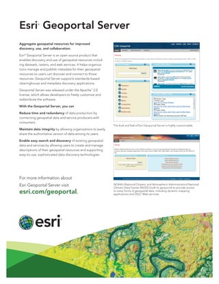
  • 1. Esri Geoportal Server ® Aggregate geospatial resources for improved discovery, use, and collaboration. Esri® Geoportal Server is an open source product that enables discovery and use of geospatial resources includ- ing datasets, rasters, and web services. It helps organiza- tions manage and publish metadata for their geospatial resources so users can discover and connect to those resources. Geoportal Server supports standards-based clearinghouse and metadata discovery applications. Geoportal Server was released under the Apache™ 2.0 license, which allows developers to freely customize and redistribute the software. With the Geoportal Server, you can Reduce time and redundancy of data production by connecting geospatial data and service producers with consumers. The look and feel of Esri Geoportal Server is highly customizable. Maintain data integrity by allowing organizations to easily share the authoritative version of data among its users. Enable easy search and discovery of existing geospatial data and services by allowing users to create and manage descriptions of their geospatial resources and supporting easy-to-use, sophisticated data discovery technologies. For more information about Esri Geoportal Server visit NOAA’s (National Oceanic and Atmospheric Administration) National Climatic Data Center (NCDC) built its geoportal to provide access esri.com/geoportal. to many forms of geospatial data, including dynamic mapping applications and OGC® Web services.
  • 2. Key Features of Esri Geoportal Server Esri Geoportal Server helps you build and administer a geoportal Web site where data producers can register their geospatial resources for users to discover and consume. The Esri Geoportal Server • Supports international data and technology standards, such as ISO, OGC, FGDC, INSPIRE, and W3C® • Catalogs existing GIS resources regardless of location or type • Facilitates discovery of GIS resources with the customizable geoportal web interface • Integrates with ArcGIS® Desktop and ArcGIS Explorer Desktop and Flex™ and Silverlight ® Web maps • Synchronizes content from other catalogs and The Geoportal of Lombardy connects the geospatial data from the geoportals region’s many organizations in one central location. • Supports REST, GeoRSS, OpenSearch, GeoJSON, KML, and HTML to expose content from the catalog service to external clients • Integrates with third-party content management systems, portal frameworks, and authentication systems Open Options with Open Source The free open source model for Geoportal Server makes it easy for you to use and customize multiple geoportals. You can deploy a geoportal for • Personal geospatial data management to aggregate your local datasets and public or enterprise services to manage and browse all your resources in one location • Collaboration with other departments and The New York State Department of Environmental Conservation uses the Geoportal Server to share its data with the public and among its organizations for general or project-specific data sharing various divisions and bureaus. • Enterprise geospatial data management to manage all your organization’s geospatial resources in one location • Communication with the public via the geoportal’s intuitive Web interface For more information about Esri Geoportal Server visit esri.com/geoportal. Copyright © 2012 Esri. All rights reserved. Esri, the Esri globe logo, ArcGIS, and esri.com are trademarks, service marks, or registered marks of Esri in the United States, the European Community, or certain other jurisdictions. Other companies and products or services mentioned herein may be trademarks, service marks, or registered marks of their respective mark owners. 130678 ESRI.25C5/12kp