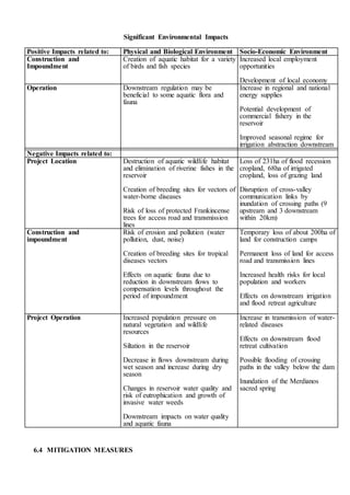
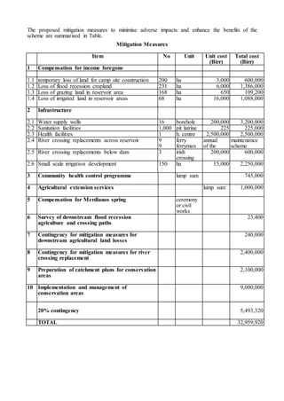
Call Girls Mumbai Gayatri 8617697112 Independent Escort Service Mumbai
Environmental impact assessment
1. ENVIRONMENTAL IMPACT ASSESSMENT
6.1 INTRODUCTION
The purpose of an Environmental Impact Assessment (EIA) is to identify the significant positive
and negative impacts of a project on the local and regional environment, and to determine
appropriate measures to exploit the benefits and mitigate any adverse effects.
Environmental Impact Assessment (EIA) to consider the study of :-
6.2 BASELINE CONDITIONS
6.2.1 Physical Environment
The project is located in the Tekeze River Basin, about 80 km to the west-south-west of
Mekele, the regional capital of Tigray. The topography of the basin is flat and relatively low lying
to the north-west, close to the Sudanese border, but is mountainous in the east, where the elevation
rises to over 4,500m in the Simien highlands. The climate is dry, with an average rainfall ranging
from less then 500 mm in the north-western lowlands to over 1400 mm in the high mountains,
mostly confined to the months June to August.
The Tekeze River drains an area of around 68,000 km² in NW Ethiopia, before joining the
River Atbara in Sudan. The damsite is situated in the middle reaches of the river, where it flows in
a generally northerly direction with a catchment area of 30,390 km². The mean annual flow at the
site is 3,750 Mm3 (119 m3/s) varying from over 1,600 Mm3/month in August to less than 17 Mm3
/month on average in the drier period December to April.
6.2.2 Biological Environment
The flora and fauna in the study area were assessed through field observations, discussions with
local inhabitants and surveys of the available literature. The investigations did not include specific
species or habitat surveys, which were outside the scope of the study.
Vegetation
The catchment to the damsite is characterised by open shrubland, widely grazed and moderately
or intensively cultivated. The natural vegetation in the project area is a mixture of Acacia-
Commiphora and Combretum-Terminalia woodland, which consists of small trees and shrubs that
are mainly drought tolerant. It is reported that the acacia woodland was much denser prior to the
severe drought in the early to mid 1980s, but today the vegetation is much degraded. Only two
species, Aloe elegans and Aloe trichosantha, are endemic, but both these are common outside the
project area. About 15-25 km from the damsite, along the access road from Adi Abi, there is is an
enclosed area with a high concentration of frankinsence trees, Boswellia papyrifera. This area has a
significant commercial value and is protected by the Regional Government.
Wildlife and Fish
The faunistic diversity of the Tekeze catchment is relatively poor, except in the Simien
National Park and the Shire Wildlife reserve, both downstream from the dam site. There is,
however, a wide variety of birdlife centred on the river corridor. Wild animal populations are low
in the project area, but species encountered around the reservoir location include mammals (leopard,
hyena, fox, baboon, etc.), reptiles (crocodile, snakes) and birds. None of the larger mammals and birds
is endemic.
The Tekeze river contains at least seven species of fish. Barbus and Clarias are migratory
species, which move seasonally between the upstream and downstream reaches of the river. Four
species also have a commercial importance.
2. 6.2.3 Socio-Economic Environment
Areas Around the Reservoir
The reservoir is adjacent to four Weredas, three in the Amhara Region (Beyeda, Sekota and
Zikuala) and one in the Tigray Region (Abergele). The total population of Peasant Associations
(PA) adjacent to the reservoir is about 52,200 people. However, there are no houses or settlements
within the area to be flooded up to the top water level of 1140m, and most of the villages are
located at least two kilometres from the river on the plateau,
In both the Tigray and Amhara regions Orthodox Christianity is the main religion (>99%), the
remainder largely being Muslims. In the Tekeze basin, the Orthodox Church generally plays a
dominant role in the village life, for example for resolving conflicts over land.
Downstream areas
The Tekeze river flows through a narrow gorge down to the Shire Wildlife Reserve before
crossing the floodplain aroung Humera, close to the international border. The Kashm-El-Girba
irrigation scheme in sited on the river, now called the Setit, in the Sudan. The first road bridge over
the river below the damsite is located at Embamadre, some 100 km downstream.
The socio-economic survey revealed a 10 ha area which is used for flood recession
cultivation on the right bank of the Tekeze river, some 20 km downstream from the dam site. The
main crops grown are cotton and red peppers. According to discussions with local people, flood
recession agriculture is probably practised further downstream, but no information is available on
the location or extent of these areas. In addition, three crossing points of the Tekeze were identified
below the dam within the 20 km reach.
6.3 POTENTIAL ENVIRONMENTAL IMPACTS
The construction and operation of the Tekeze Hydropower Project will lead to a variety of
changes in the local and wider environment. Many of the effects will be beneficial, particularly the
impact at a national level of increasing the availability of electrical energy, and the potential to
develop the local economy through improved infrastructure and employment opportunities. There
will nevertheless be adverse effects, some of which will be short-term and reversible, but others that
will lead to permanent change. Although the scale and magnitude of many impacts cannot be
predicted accurately, their recognition at an early phase of the project development enables
mitigating measures, where these are practicable, to be incorporated into the design, and monitoring
programmes to be set up to assess the need for remedial action. An awareness of the residual
environmental implications of the project is also fundamental for a balanced decision as to whether
or not the project should be initiated.
6.3.1 Positive Impacts
The project will potentially have a number of beneficial impacts on the natural and the
socio-economic environment, both during its construction and its operational life. The
positive effects in the physical and biological domain and the anticipated socio-economic
benefits are discussed below
Natural Environment
The lake will naturally develop populations of stagnant water fish species, which will lead to a
significant increase in the total fish biomass in the Tekeze river. The reservoir also offers a
potential for the development of a commercial fishery.
Socio-Economic Environment
Positive socio-economic impacts may be anticipated from the regional development stemming from
the project. During the construction phase there will be improved employment opportunities for
local people, for work constructing the civil works, access road, camp and transmission lines.
There will also be a temporary surge in economic activity during the construction phase, and new
markets and services will develop in the area to provide goods and services for the workers and
their families
3. Under operation, the main positive impact will be the generation of reliable energy for Ethiopia.
Negative Impacts
The following section summarises the main negative impacts of the project on the physical,
biological and socio-economic environment, and includes a specific assessment of the potential
impacts downstream of the dam.
Physical impacts
The construction activities will give rise to a temporary local deterioration in air quality, and will
produce high noise levels and vibration. The construction works and the removal the vegetation
cover in the reservoir area prior to first filling will increase the risk of erosion in area, leading to the
loss of fertile soils and higher rates of sedimentation in the river.
Biological impacts
This area includes a significant number of important riverine forest and savannah woodland
vegetation communities, and their loss will reduce both the region’s biodiversity and the availability
of wildlife habitats. The natural forest cover is critical for the maintenance of soil stability, and
plays an important role in protecting against erosion and increased sedimentation in the drainage
system. Forests and woodland ecosystems also contain a wide range of plant species of commercial
and domestic importance.
4. 6.3.2 Summary of Significant Environmental Impacts
6.3.1 Summary of Significant Environmental Impacts
The main positive and negative impacts predicted to arise from the scheme are summarised in Table
5. Significant Environmental Impacts
Positive Impacts related to: Physical and Biological Environment Socio-Economic Environment
Construction and
Impoundment
Creation of aquatic habitat for a variety
of birds and fish species
Increased local employment
opportunities
Development of local economy
Operation Downstream regulation may be
beneficial to some aquatic flora and
fauna
Increase in regional and national
energy supplies
Potential development of
commercial fishery in the
reservoir
Improved seasonal regime for
irrigation abstraction downstream
Negative Impacts related to:
Project Location Destruction of aquatic wildlife habitat
and elimination of riverine fishes in the
reservoir
Creation of breeding sites for vectors of
water-borne diseases
Risk of loss of protected Frankincense
trees for access road and transmission
lines
Loss of 231ha of flood recession
cropland, 68ha of irrigated
cropland, loss of grazing land
Disruption of cross-valley
communication links by
inundation of crossing paths (9
upstream and 3 downstream
within 20km)
Construction and
impoundment
Risk of erosion and pollution (water
pollution, dust, noise)
Creation of breeding sites for tropical
diseases vectors
Effects on aquatic fauna due to
reduction in downstream flows to
compensation levels throughout the
period of impoundment
Temporary loss of about 200ha of
land for construction camps
Permanent loss of land for access
road and transmission lines
Increased health risks for local
population and workers
Effects on downstream irrigation
and flood retreat agriculture
Project Operation Increased population pressure on
natural vegetation and wildlife
resources
Siltation in the reservoir
Decrease in flows downstream during
wet season and increase during dry
season
Changes in reservoir water quality and
risk of eutrophication and growth of
invasive water weeds
Downstream impacts on water quality
and aquatic fauna
Increase in transmission of water-
related diseases
Effects on downstream flood
retreat cultivation
Possible flooding of crossing
paths in the valley below the dam
Inundation of the Merdianos
sacred spring
6.4 MITIGATION MEASURES
6. The proposed mitigation measures to minimise adverse impacts and enhance the benefits of the
scheme are summarised in Table.
Mitigation Measures
Item No Unit Unit cost Total cost
(Birr) (Birr)
1 Compensation for income foregone
1.1 temporary loss of land for camp site cosntruction 200 ha 3,000 600,000
1.2 Loss of flood recession cropland 231 ha 6,000 1,386,000
1.3 Loss of grazing land in reservoir area 168 ha 650 109,200
1.4 Loss of irrigated land in reservoir areas 68 ha 16,000 1,088,000
2 Infrastructure
2.1 Water supply wells 16 borehole 200,000 3,200,000
2.2 Sanitation facilities 1,000 pit latrine 225 225,000
2.3 Health facilities 1 h. centre 2,500,000 2,500,000
2.4 River crossing replacements across reservoir 9 ferry annual maintenance
9 ferryman of the scheme
2.5 River crossing replacements below dam 3 irish
crossing
200,000 600,000
2.6 Small scale irrigation development 150 ha 15,000 2,250,000
3 Community health control programme lump sum 745,000
4 Agricultural extension services lump sum 1,000,000
5 Compensation for Merdianos spring ceremony
or civil
works
6 Survey of downstream flood recession
agriculture and crossing paths
23,400
7 Contingency for mitigation measures for
downstream agricultural land losses
240,000
8 Contingency for mitigation measures for river
crossing replacement
2,400,000
9 Preparation of catchment plans for conservation
areas
2,100,000
10 Implementation and management of
conservation areas
9,000,000
20% contingency 5,493,320
TOTAL 32,959,920
7. 6.5 MONITORING PLAN
An appropriate monitoring programme is recommended to verify the magnitude and scale of the
predicted impacts, and to detect any unforeseen impacts at an early stage. One of the most
important aims of monitoring is to ensure that any necessary corrective action arising from
unforeseen adverse impacts, or from different magnitudes of recognised impacts, is undertaken
before significant environmental damage results.
The EIA studies have shown that there has been relatively little monitoring of existing
environmental conditions in the area. It is therefore important to establish a monitoring programme
prior to the start of construction, in order to establish background conditions against which future
change can be assessed.
Monitoring Activities and Costs
Subject Activity Frequency Responsible Organisation
Water Quality Survey of the physico-
chemical parameters of the
reservoir water
quarterly for 5 years MWR
Fishery Fisheries monitoring in the
river and reservoir
quarterly for 5 years Ministry of Agriculture
- Fisheries Sector
Health Survey of disease vectors
(mosquitoes and snails)
annual survey for 5
years
Ministry of Health
Human health survey annual survey for 3
years
Ministry of Health - Malaria
Control Office
Environmental
co-ordination
Compensation plan 6 man months MWR or EELPA
20%
contingency
214,000
TOTAL 1,284,000