SlideShare a Scribd company logo
EGEO 1 Lesson 01 Notes
THE EARTH: SURFACES, STRUCTURE AND AGE
The science of Geology is concerned with the Earth and the rocks
of which it is composed, the processes by which they were formed during
geological time, and the modelling of the Earth's surface in the past and at
the present day. Surface changes can be observed by engineers and
geologists alike; among them erosion is a dominant process which in time
destroys coastal cliffs, reduces the height of continents, and transports the
material so removed either to the sea or to inland basins of deposition.
Changes that originate below the surface are not so easily observed and
their nature can only be postulated. Some are the cause of slow movements
of continents across the surface of the globe; others cause the more rapid
changes associated with volcanic eruptions and earthquakes.
Geological processes such as those which operate at the present
day have, during the very large span of geological time, left their record in
the rocks - sometimes clearly, sometimes partly obliterated by later events.
The rocks therefore record events in the long history of the Earth, as
illustrated by the remains or marks of living organisms, animals or plants,
when preserved; all rocks make their contribution to the record.
The term rock is used for those materials of many kinds which
form the greater part of the relatively thin outer shell, or crust, of the Earth;
some are comparatively soft and easily deformed and others are hard and
rigid. Three broad rock groups are distinguished, on the basis of their origins
rather than their composition or strength:
❑ Igneous Rocks – derived from hot material that originated below
the Earth's surface and solidified at or near the surface (e.g.
basalt, granite, and their derivatives).
❑ Sedimentary Rocks - mainly formed from the breakdown
products of older rocks, the fragments having been sorted by
water or wind and built up into deposits of sediment (e.g.
sandstone, shale); some rocks in this group have been formed by
chemical deposition (e.g. some limestones). The remains of
organisms such as marine shells or parts of plants that once lived
in the waters and on the land where sediment accumulated, can
be found as fossils.
❑ Metamorphic Rocks - derived from earlier igneous or
sedimentary rocks, but transformed from their original state by
heat or pressure, so as to acquire conspicuous new
characteristics (e.g. slate, schist, gneiss).
Rocks are made up of small crystalline units known as minerals
and a rock can thus be defined as an assemblage of particular minerals, and
named accordingly. For engineering purposes, however, the two terms 'rock'
and 'soil' have also been adopted to define the mechanical characters of
geological materials. 'Rock' is a hard material and 'soil' either a sediment
which has not yet become rock-like, or a granular residue from rock that has
completely weathered (called a residual soil). Rocks and soils contain pores
and fissures that may be filled either with liquid or with gas: e.g. water or air.
Such voids may be very small but can make up a considerable proportion of
a rock or soil mass.
The Surface of the Earth
Dimensions and Surface Relief
The radius of the Earth at the equator is 6370 km and the polar
radius is shorter by about 22 km; thus the Earth is not quite a perfect sphere.
The planet has a surface area of 510 x 106
km², of which some 29 percent
is land.
The Interior of the Earth
Temperature Gradient and Density
The mean mass density of the Earth, which is found from its size
and motion around the Sun, is 5.527 g cm−3
. This is greater than the
density of most rocks found at the surface, which rarely exceeds 3;
sedimentary rocks average 2.3, and the abundant igneous rock granite about
2.7. This has been confirmed from the study of the elastic waves generated
by earthquakes, in particular from research into the way in which earthquake
waves are bent (by diffraction at certain boundaries) as they pass through
the Earth: our knowledge of the Earth's interior comes mainly from such
studies. These have shown that our planet has a core of heavy material with
a density of about 8. Two metals, iron and nickel, have densities a little below
and above 8 respectively, and the core is believed to be a mixture of these
composed mainly of iron.
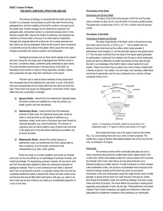
Figure 1.3. Composition of the Earth; depths from the surface in km;
temperature scale in °K; figures on left are mass density in x10³ kg/m³.
Surrounding this heavy core is the region known as the mantle
(Fig. 1.3); and overlying that is the crust, which is itself composite. The
mantle has a range of density intermediate between that of the crust and the
core, as indicated in the figure.
Earthquake
The numerous shocks which continually take place are due to
sharp movements along fractures (called faults) which relieve stress in the
crustal rocks. Stress accumulates locally from various causes until it exceeds
the strength of the rocks, when failure and slip along fractures occur,
followed usually by a smaller rebound. A small movement on a fault, perhaps
a few centimeters or less, can produce a considerable shock because of the
amount of energy involved and the fault may 'grow' by successive
movements of this kind. Earthquakes range from slight tremors which do little
damage, to severe shocks which can open fissures in the ground, initiate
fault scarps and landslides, break and overthrow buildings, and sever supply
mains and lines of transport. The worst effects are produced in weak ground,
especially young deposits of sand, silt and clay. These sediments may shake
violently if their moduli of elasticity and rigidity are insufficient to attenuate
adequately the acceleration imparted to their particles by an earthquake.
EGEO 1 Lesson 01 Notes
Prior to a major earthquake, strain in the crust accumulates to the
extent that small changes may be noticed in the shape of the land surface, in
water levels, in the flow, temperature and chemistry of springs, in the
magnetic properties of the strained crust and the velocity with which it
transmits vibrations, and in the frequency and location of very small (micro)
earthquakes. These precursors are studied in an attempt to predict location
and time of major earthquakes. When a major earthquake at sea rapidly
changes the elevation of the ocean floor, a volume is created that has to be
filled by sea-water. Sea level drops, sometimes causing beaches in the
region to be exposed, and large waves, called tsunamis, may be generated
as sea-level reestablishes itself: these can devastate coastal areas when
they strike a shoreline.
The intensity of an earthquake can be estimated from the effects
felt or seen by an observer, and such observations are collected and used to
determine the centre of the disturbance. They are graded according to a Scale
of Intensity such as the Mercalli Scale, which has twelve grades:
Grade I. Detected only by instruments.
Grade II. Felt by some persons at rest; suspended objects may swing.
Grade III. Felt noticeably indoors; vibration like the passing of a truck.
Grade IV. Felt indoors by many, outdoors by some; windows and doors
rattle.
Grade V. Felt by nearly everyone; some
Grade VI. Felt by all, many frightened; some heavy furniture moved, some
fallen plaster; general damage slight.
Grade VII. Everyone runs outdoors; damage to poorly constructed buildings;
chimneys fall.
Grade VIII. Much damage to buildings, except those specially designed. Tall
chimneys, columns fall; sand and mud flow from cracks in
ground.
Grade IX. Damage considerable in substantial buildings; ground cracked,
buried pipes broken.
Grade X. Disastrous; framed buildings destroyed, rails bent, small
landslides.
Grade XI. Few structures left standing; wide fissures opened in ground, with
slumps and landslides.
Grade XII. Damage total; ground warped, waves seen moving through
ground, objects thrown upwards.
The observed intensity at points in the area affected can be
marked on a map, and lines of equal intensity (isoseismal lines) then drawn
to enclose those points where damage of a certain degree is done giving an
isoseismal map. A more accurate measure of earthquake activity is provided
by the amount of seismic energy released in an earthquake; this defines its
magnitude, for which the symbol M is used. The Scale of Magnitudes due to
C. F. Richter (1952) and now in general use is based on the maximum
amplitudes shown on records made with a standard seismometer. The
smallest felt shocks have M= 2 to 2 1/2. Damaging shocks have M =5 or
more; and any earthquake greater than M= 7 is a major disaster. The Richter
Scale of Magnitudes and the Mercalli Scale of Intensities are not strictly
comparable; but M= 5 corresponds roughly with Grade VI (damage to
chimneys, plaster, etc.) on the Mercalli Scale. The historic record of
earthquakes reveals that shocks of large magnitude occur less frequently
than those of lesser magnitude. A relationship exists between the magnitude
of an earthquake that is likely to occur at a location and its return period, and
this relationship is used to select the accelerations that must be resisted by
the earthquake resisting structures for the locality. When an earthquake
occurs elastic vibrations (or waves) are propagated in all directions from its
center of origin, or focus; the point on the Earth's surface immediately above
the earthquake focus is called the epicenter: here the effects are usually
most intense. Two kinds of wave are recorded:
(i) body waves, comprising of compressional vibrations, called
primary or P waves, which are the fastest and the first to
arrive at a recording station, and transverse or shear
vibrations, called S waves, a little slower than the P waves;
and
(ii) surface waves, (or L-waves) similar to the ripples seen
expanding from the point where a stone is dropped into
water, and created by Love-wave (LQ) and Rayleigh-wave
(LR) ground motions.
Figure 1.6. Paths of earthquake waves through the earth.
Surface waves are of long period that follow the periphery of the
Earth; they are the slowest but have a large amplitude and do the greatest
damage at the surface: M is calculated from their amplitude. For a distant
earthquake, seismographs situated at distances up to 105° of arc from the
epicentre record the onsets of P, S, and L waves (Fig. 1.6). Between 105°
and 142° of arc, the region known as the 'shadow zone', no P or S waves
arrive, but from 142° onwards the P waves are again received. They have,
however, taken longer to travel and hence must have been slowed down
over some part of their path through the Earth. The transverse S vibrations
are not transmitted through the core, indicating that it has the properties of a
fluid (which would not transmit shear vibrations).
Figure 1.7. Seismic waves radiating from the location where crustal
fracture has occurred, the focus (F), and travelling through the
continental crust and uppermost mantle at velocities Pg and Sg, P*
and S*, and P and S.
In Fig. 1.7, the set Pg and Sg follow the direct path in an upper
(granitic) layer, while the set P and S are refracted at the boundary of a lower
layer and travel there with a higher velocity because the material of the lower
layer is denser. This boundary may be considered to mark the base of the
crust and is called the Mohorovicic discontinuity, or 'the Moho'. Later a third
set of vibrations was detected on some seismograms; they are called P* and
S* and have velocities lying between those of the other two sets. They follow
a path in the layer below the granitic layer (Fig. 1.7).
EGEO 1 Lesson 01 Notes
These values correspond to those derived from elasticity tests in
the laboratory on the igneous rocks granite, basalt, and peridotite
respectively. Peridotite is a rock whose mineralogy is formed at pressures
and temperatures similar to those expected in the upper mantle. Thus the
fastest waves, P and S, travel for the greater part of their course in material
of peridotite composition, in the upper part of the mantle just below the
Moho. Above the Moho is the basaltic crust or basaltic layer, in which the P*
and S* waves travel. The granitic layer, which forms the upper part of the
continental crust, transmits the Pg and Sg vibrations.
Continental Drift
Lands in the southern hemisphere including South America, Africa,
Antarctica, Australia, and peninsular India formed a large continent, called
Gondwanaland (Fig. 1.12), some 400 my ago in Carboniferous times; they
have since moved apart to their present positions. When Antarctica and
Australia (with New Zealand) lie together as shown in the figure, certain
geological features (g) of the two continents become aligned; also the west
side of India and Sri Lanka when alongside east Africa show a correspondence
of particular rocks.
Figure 1.12. Reconstruction of Gondwanaland
Mechanism of Drift
Continental drift is associated with the opening and extension of
the ocean floor at the oceanic ridges. The temperatures of rocks near the
centre of a ridge are higher than on either side of it, because material from
the mantle rises towards the surface in the hotter central part of a ridge. The
cause of this upward flow is believed to be the operation of slow-moving
convention currents in the Earth's mantle (Fig. 1.16). The currents rise
towards the base of the lithosphere and spread out horizontally, passing the
continental margins and descending again. The hotter rock-material in the
rising current is less dense and possesses buoyancy, which is the driving
force of the mechanism. Differences in the rate of movement of adjacent
masses away from the oceanic ridges are accommodated by displacement
on fractures called transcurrent faults. The recognition of extensive fracture
systems, with horizontal displacements of hundreds of kilometers, has shown
that large fault movements form part of the architecture of the Earth's crust.
All these are transcurrent faults involving horizontal movements parallel to
the line of the fault; similar extensive fractures are located in the ocean
floors.
Plate Tectonics
When the validity of continental drift became accepted, in the mid-
1960s, the idea was advanced that the outer shell of the Earth, the
lithosphere, could be considered as a mosaic of twelve or more large rigid
plates. These plates were free to move with respect to the underlying
asthenosphere, and could also move relatively to one another in three ways:
(i) by one plate sliding past another along its margin;
(ii) by two plates moving away from one another;
(iii) by two plates moving together and one sliding underneath the
edge of the other.
The first of these is expressed at the Earth's surface by
movement along major transcurrent faults, such as the San Andreas fault.
The second type of movement is shown by the formation of oceanic ridges.
The third kind of movement is expressed by the deep ocean trenches, where
the edge of one plate has moved downwards under the other and is
dispersed in the mantle, a process known as subduction. A distinction must
be made between continental plate and oceanic plate. The former is capped
by continental crust, i.e. the continents 'ride' on the underlying plate. Six of
these major plates are distinguished, namely the North American, South
American, Eurasian, African, Indo-Australian, and Pacific Plates; there are
many other smaller plates whose movements are more difficult to determine.
Oceanic plate is covered by a thin oceanic crust, mainly basaltic
in composition and having a thin covering of sediments (Fig. 1.18). The term
plate tectonics came to be used to denote the processes involved in the
movements and interactions of the plates ('tectonic' is derived from Greek
tekton, a builder).
Earth age and origin
The Earth and other members of the Solar System are believed to
have been formed about 4600 million years ago by condensation from a
flattened rotating cloud of gas and dust. This contracted slowly, giving rise to
the primitive Sun at its centre - a new star - surrounded by a mass of cosmic
gases in which local condensations generated the planets. They, and other
bodies such as the asteroids and meteorites, all revolve in the same direction
in orbits around the Sun. The cold primitive Earth became gradually heated
as its interior was compressed by the increasing weight of accumulated
matter and by the decay of natural radioactive materials. Heat was produced
more quickly than it could escape from the compressed mass, resulting in
the melting of some constituents and heavier matter being drawn by gravity
towards the Earth's centre. The planet thus gradually acquired a core,
surrounded by a mantle of less dense material, and an outer crust. The
primitive crust was probably basaltic, and was cracked and re-melted, with
the separation of lighter (granitic) fluids, which accumulated and eventually
contributed to the material of the continents.
EARTH PROCESSES
What are Earth Processes?
- Earth surface processes include weathering;
sediment production by weathering and
biochemical or chemical precipitation; erosion,
transport, and deposition of sediment under the
influence of gravity, flowing water, air, and ice;
earthquakes and Earth surface motions; volcanic
eruptions and movement of volcanic ejecta. All
around us, the earth is in a constant state of
change, and it’s been that way since its formation.
Some of these changes happen extremely slowly,
while others happen in an instant. Some take place
on a microscopic scale; others affect the entire
plane.
The most gradual processes include:
a.) Formation of Mountains and Oceans-
Mountains are formed by tectonic plates moving
together and pushing up until tall structures are
formed. The ocean formed billions of years ago.
Water remained a gas until the Earth cooled below
212⁰F. At this time, about 3.8 billion years ago, the
water condensed into rain which filled the basins
that we now know as our world ocean.
b.) Continental Drift- The gradual movement of the
continents across the earth’s surface through
geological time.
c.) Deposition- The laying down of sediment
carried by wind, flowing water, the sea or ice.
d.) Erosion- Rain, rivers, floods, lakes, and the
ocean carry away bits of soil and sand and slowly
wash away the sediment.
The fastest processes include:
a.) Earthquake- The underground rock suddenly
breaks and there is rapid motion along fault.
b.) Eruption- When enough magma builds up in
the magma chamber, it forces its way up to the
surface and erupts.
c.) Asteroid Impacts- A rocky, metallic (typically
iron), or icy body that had been orbiting the Sun
passes through the atmosphere to hit the Earth’s
surface.
d.) Motion of Currents- Winds drive currents that
are at or near the ocean’s surface.
e.) Water Cycle- Liquid water evaporates into
water vapor, condenses to form clouds, and
precipitates back to earth in the form of rain and
snow.
f.) Weather Processes- When water evaporates
from places like oceans and lakes, and then
condenses when it cools down again.
Other processes happen relatively quickly on the
geologic time scale, but still very slowly from a
human standpoint, like glacial flow, climate change,
weathering, and other types of erosion.
The largest processes on a physical scale occur
globally, like plate tectonics, the circulation of the
oceans and atmosphere, and very large impacts
and eruptions.
The smallest processes happen on a
microscopic scale. These include mineral
crystallization, chemical reactions within rocks, and
other interactions between atoms and molecules.
WEATHERING
- The process where rocks are dissolved, worn
away or broken down into smaller and smaller
pieces.
WEATHERING PROCESS
a.) Mechanical Weathering- Sometimes called
physical weathering, and it describes the process of
rocks crumbling.
Processes Of Mechanical Weathering
• Mechanical Unloading
• Mechanical Loading
• Thermal Loading
• Wetting and Drying
• Crystallization
• Pneumatic Loading
b.) Chemical Weathering- It involves the reaction
of some chemicals on rocks. It happens in light of
the fact that the procedures are progressive and
continuous, subsequently changing the mineralogy
of the stones after some time that makes them to
erode, break down, or crumble. Some rocks such
as limestone and chalk are more prone to chemical
weathering than others, like granite.
Processes Of Chemical Weathering
• Solution
• Oxidation
• Reduction
• Hydration
• Hydrolysis
• Leaching
• Cation Exchange
c.) Organic Weathering- Also called bio-
weathering or biological weathering, is the
general name for biological processes of
weathering that break down rocks. This
includes the physical penetration and growth of
roots and digging activities of animals
(bioturbation), as well as the action of lichens
and moss on various minerals.
Processes Of Organic Weathering
• Burrowing Animals
• Growing Plant Roots
• Microbial Activity
• Human Activities
WORKS OF RIVERS, WIND, AND SEA
- Rivers, wind, moving ice and water waves are
capable of loosening, dislodging and carrying
particles of soil, sediment and larger pieces of
rock. They are therefore described as the
agents of erosion.
a.) Works of Rivers- A river is a natural flowing
watercourse, usually freshwater, flowing
towards an ocean, sea, lake or another river. In
some cases, a river flows into the ground and
becomes dry at the end of its course without
reaching another body of water. Small rivers
can be referred to using names such as stream,
creek, brook, rivulet, and rill.
Works of Rivers
• Erosion- The breaking of rocks by the river
in along its course is called erosion.
Erosional work of a river is performed
mechanically and chemically. River erosion
is carried out in the following way:
*Hydraulic Action- Refers to the physical
force of the moving water which breaks the
rocks in its course.
*Corrasion- Refers to the breaking of rock in
the bed and on the bank by fragments
carried by the stream.
*Corrosion- It refers to the dissolving
process of soluble minerals by the splashing
of stream water.
*Attrition- Refers to the eroded materials
carried by the stream strike against each
other.
• Transportation- Stream carrying the
fragmented materials broken by the stream
is called transportation. After erosion, the
eroded materials get transported along with
the running water. This transportation of
eroded materials is carried in four ways:
*Traction- The heavier and larger rock
fragments like gravels and pebbles are
forced by the flow of the river to roll along its
bed. These fragments can be seen rolling,
slipping, bumping and being dragged.
*Saltation- Some of the fragments of the
rocks move along the bed of a stream by
bouncing continuously.
*Suspension- The holding up of small
particles of sand, silt, and mud by the water
as the stream flows.
*Solution- Some parts of the rock fragments
dissolve in the river water and transported.
This type of transportation is called solution
transportation.
• Deposition- When the velocity of the
stream decreases, the stream deposits
sand, silt and other fragments. It is called as
the deposition. When a river moves in a
gentle slope, its speed reduces and river
begins to deposit its load. The river starts
depositing larger materials first and smaller
and finer materials are carried further down
to the mouth of the river.
b.) Works of Wind- The earth is surrounded by
an envelope of gases called the atmosphere.
The movement of the atmosphere in a direction
parallel to the earth surface is wind. i.e., the air
in motion is called wind whereas the vertical
movements of the atmosphere are termed as
air currents.
Wind Erosion Process
• Deflation- Process of simply removing the
loose sand and dust sized particles from as
area, by fast moving winds. Wind deflation
can successfully operate in comparatively
dry regions with little or no rainfall and
where the mantle is unprotected due to
absence of vegetation.
• Abrasion- The wind loaded with such
particles attains a considerable erosive
power which helps in eroding the rock
surfaces by rubbing and grinding actions
and produce many changes.
Transportation By Wind
The total sediment load carried by a wind can
be divided into two parts: Bed Load &
Suspended Load
WIND TURBINE- a machine that converts
kinetic energy from the wind into electricity.
c.) Works of Sea- Sea is an extensively
developed continuous body of salt water having
inland extensions or embayment. The average
depth of the sea is generally less than four km.
In almost all cases, seas are shallower parts of
large water bodies called the Oceans.
Exceptionally deep seas (with an average depth
greater than 4 km) having extensive areas and
gigantic underwater features are called Oceans.
A sea is thus part of ocean which is closer to
continental land.
MARINE WATER- It is spread over more than
2/3 of the earth’s surface and is classified
among the most powerful geological agents
operating on the earth. It also acts as an agent
of erosion, transport and deposition.
Marine Erosion- Marine water erodes the rocks
at the shore and elsewhere with which it comes
in contact in a manner broadly similar to that of
stream water. The work of erosion is
accomplished in three ways:
• Hydraulic Action- Process of erosion by
water involving breaking, loosening and
plucking out of loose, disjointed blocks
of rocks from their original places by the
strong forces created by the impact of
sea waves and currents.
• Marine Abrasion- This involves the
rubbing and grinding action of seawater
on the rocks of the shore with the help
of sand particles and other small
fragments that are hurdled up again
these rocks.
• Corrosion- It is the solvent action of
seawater which is particularly strong in
environment where the shore is of
vulnerable chemical composition.
EARTHQUAKE
-The numerous shocks which continually take place
are due to sharp movements along fractures (called
faults) which relieve stress in the crustal rocks.
-A sudden and violent shaking of the ground,
sometimes causing great destruction, as a result of
movements within the earth's crust or volcanic
action.
HOW EARTHQUAKE IS FORMED?
-Stress accumulates locally from various causes
until it exceeds the strength of the rocks, when
failure and slip along fractures occur, followed
usually by a smaller rebound.
-A small movement on a fault, perhaps a few
centimeters or less, can produce a considerable
shock because of the amount of energy involved
and the fault may 'grow' by successive movements
of this kind.
Earthquakes range from slight tremors to severe
shocks.
- Little Damage
- Fissures on the ground
- Fault scarp and landslide
- Break and overthrow buildings
- Sever supply mains and lines of transport
- The worst effects are produced in weak ground,
especially young deposits of sand, silt and clay.
Lives and Property may be saved if Earthquake
Resistant Structures are built
STRESS- forces that push, pull, or twist the earth’s
crust constantly.
STRAIN- deformation or any change in volume or
shape of the earth’s rock.
TSUNAMIS- When a major earthquake at sea
rapidly changes the elevation of the ocean floor, a
volume is created that has to be filled by sea-water.
Sea level drops, sometimes causing beaches in the
region to be exposed, and large waves, called
tsunamis, may be generated as sea-level
reestablishes itself.
What is the difference between intensity and
magnitude?
-Intensity measures the strength of shaking
produced by the earthquake at a certain location.
Intensity is determined from effects on people,
human structures, and the natural environment.
-Magnitude measures the energy released at the
source of the earthquake. Magnitude is determined
from measurements on seismographs.
MERCALLI SCALE OF INTENSITIES
I Detected only by instruments.
II Felt by some persons at rest; suspended objects
may swing.
III Felt noticeably indoors; vibration like the passing
of a truck.
IV Felt indoors by many, outdoors by some;
windows and doors rattle.
V Felt by nearly everyone; some windows broken;
pendulum clocks stop.
VI Felt by all, many frightened; some heavy
furniture moved, some fallen plaster; general
damage slight.
VII Everyone runs outdoors; damage to poorly
constructed buildings; weak chimneys fall.
VIII Much damage to buildings, except those
specially designed. Tall chimneys, columns fall;
sand and mud flow from cracks in the ground.
IX Damage considerable in substantial buildings;
ground cracked, buried pipes broken.
X Disastrous; framed buildings destroyed, rails
bent, small landslides.
XI Few structures left standing; wide fissures
opened in the ground, with slumps and landslides.
XII Damage total; ground warped, waves seen
moving through ground, objects thrown upwards
THE RICHTER SCALE OF MAGNITUDES- The
scale is logarithmic and is related to the elastic
wave energy (E), measured in joules, M ranges
from magnitude 0 to magnitude 9.
Damaging shocks have M =5 or more; and any
earthquake greater than M= 7 is a major disaster.
SEISMOGRAPH - an instrument consisting
essentially of a lightly suspended beam which is
pivoted to a frame fixed to the ground, and which
carries a heavy mass. It measures seismic waves.
Two kinds of wave are recorded:
1. Body waves
• Primary waves or P waves - the fastest and
the first to arrive at a recording station
• Transverse/Shear vibrations or s waves - a
little slower than P waves
2. Surface waves are of long period that follow the
periphery of the Earth; they are the slowest but
have a large amplitude and do the greatest damage
at the surface
• Love-wave or LQ wave - vibrates the
ground in the horizontal direction
perpendicular to the direction that the waves
are traveling.
• Rayleigh-wave or LR wave - moves in an
elliptical motion, producing both a vertical
and horizontal component of motion in the
direction of wave propagation.
EPICENTER - the point on the Earth's surface
immediately above the earthquake focus.
FOCUS - point inside the earth where the
earthquake started. When an earthquake occurs
elastic vibrations (or waves) are propagated in all
directions from its center of origin, or focus.
GROUNDWATER
- Water found underground in the cracks and
spaces in soil, sand and rock. It is the fluid most
commonly encountered in engineering construction.
UNSATURATED ZONE- The region where the soil
is not saturated
SATURATED ZONE- The groundwater completely
fills any open spaces underground
WATER TABLE- The boundary where the
saturated and unsaturated zones meet
Water Cycle
-Groundwater is an important component of the
water cycle, which is the natural cycling of water
through phases and locations on Earth. The water
that soaks into the ground sometimes comes back
out above ground in other locations, feeding the
world’s rivers, lakes, streams, and oceans.
GEYSER- It is a rare kind of hot spring that is under
pressure and erupts, sending jets of water and
steam into the air.
AQUIFER- Rocks and soils that transmit water with
ease through their pores and fractures. Typical
aquifers are gravel, sand, sandstone, limestone
and fractured igneous and metamorphic rocks.
AQUITARDS- Also called aquicludes are rocks and
soils that transmit water with difficulty. Typical
aquicludes are clay, mudstone, shale, evaporite
and unfractured igneous and metamorphic rocks.
Infiltration- The flow of water from above ground
into the subsurface
Percolation- The process by which water moves
downward through the soil under gravitational
forces
Natural ecosystems depend on groundwater
because, as mentioned before, it’s a source of
freshwater for surface water systems, like wetlands
and rivers. Both plants and animals depend on
groundwater because plants take it up through their
roots in the soil, and animals use it as a source of
drinking water.
Mineralogy
- is a scientific discipline that is concerned with all aspects of minerals, including their physical
properties, chemical composition, internal crystal structure, occurrence, distribution in nature, and their
origins in terms of the physicochemical conditions of formation.
Elements of Crystallographic System
Crystallography is the branch of science that deals with discerning the arrangement and bonding of
atoms in crystalline solids and crystal lattices’ geometric structures. Classically, the optical properties of
crystals were of value in mineralogy and chemistry for the identification of substances.
There are six crystal systems. All minerals form crystals in one of these six systems. Although you may
have seen more than six shapes of crystals, they’re all variations of one of these six habits. Each system
is defined by a combination of three factors:
1. How many axes it has.
2. The lengths of the axes.
3. The angles at which the axes meet.
An axis is a direction between the sides. The shortest one is A. The longest is C. There is also a B axis and
sometimes a D axis.
Physical Properties of Minerals
Most minerals can be characterized and classified by their unique physical properties:
(a) Hardness
(b) Luster
(c) Color
(d) Streak
(e) specific gravity
(f) Cleavage
(g) Fracture
(h) Tenacity
HARDNESS is the ability to resist being scratched and it is one of the most useful properties for
identifying minerals. Hardness is also determined by the ability of one mineral to scratch another.
Federick Mohs, a German mineralogist, produced a hardness scale using a set of ten standard
minerals. The scale arranges the minerals in order of increasing hardness. Each higher-
numbered(harder) mineral will scratch any mineral with a lower number(softer).
LUSTER refers to the general appearance of a mineral surface to reflected light. The general types of
luster are designated as follows:
1. Metallic - looks shiny like a metal. Usually opaque and gives black or dark colored streak.
2. Non-metallic - Non metallic lusters are referred to as
a) vitreous - looks glassy - examples: clear quartz, tourmaline
b) resinous - looks resinous - examples: sphalerite, sulfur.
c) pearly - iridescent pearl-like - example: apophyllite.
d) greasy - appears to be covered with a thin layer of oil - example: nepheline.
e) silky - looks fibrous. - examples - some gypsum, serpentine, malachite.
f) adamantine - brilliant luster like diamond
COLOR is one of the most obvious properties of a mineral is color. It should be considered when
identifying a mineral, but in some minerals like quartz, calcite, garnet, tourmaline and others, color may
be the result of slight impurities and will vary greatly.
STREAK is the color of the powdered mineral, which is usually more useful for identification than the
color of the whole mineral sample. Rubbing the mineral on a streak plate will produce a streak. A streak
plate can be made from the unglazed back side of a white porcelain bathroom or kitchen tile. Some
minerals won't streak because they are harder than the streak plate.
SPECIFIC GRAVITY is the ratio between the mass (weight) of a mineral and the mass (weight) of an
equal volume of water. A mineral's specific gravity (SG) can be determined by dividing its weight in air
by the weight of an equal volume of water. For instance, quartz with a density of 2.65 is 2.65 times as
heavy as the same volume of water.
SG =
MINERAL MASS
WATER MASS
CLEAVAGE is the way in which a mineral breaks along smooth flat planes. These breaks occur along
planes of weakness in the mineral's structure. However, if a mineral breaks along an irregular surface, it
does not have cleavage.
FRACTURE is when a mineral breaks irregularly, the breaks are called fractures. Several different kinds
of fracture patterns are observed.
1. Conchoidal fracture - breaks along smooth curved surfaces
2. Fibrous and splintery - similar to the way wood breaks.
3. Hackly - jagged fractures with sharp edges
4. Uneven or Irregular - rough irregular surface
TENACITY is how well a mineral resists breakage. The terms used to describe are:
1. Brittle - mineral crushes to angular fragments (quartz)
2. Malleable - mineral can be modified in shape without breaking and can be flattened to a thin
sheet (copper, gold)
3. Sectile - mineral can be cut with a knife into thin shavings (talc)
4. Flexible - mineral bends but doesn't regain its shape once released (selenite, gypsum)
5. Elastic - mineral bends and regains its original shape when released (muscovite and biotite mica)
Other characteristics may be useful in identifying some minerals:
1. Transparency - objects are visible when viewed through a mineral.
2. Translucency - light, but not an image, is transmitted through a mineral
3. Opaqueness - no light is transmitted, even on the thinnest edges
4. Taste - can be used to help identify some minerals, such as halite (salt).
5. Acid reaction - object reacts to hydrochloric acid.
6. Magnetism - is a distinguishing characteristic of magnetite.
7. Radioactivity - a Geiger counter is used to determine the amount of radioactivity
8. Florescence - its appearance under ultra violet light
9. Crystal shape - Cubic, rhombohedral (tilted cube), hexagonal (six-sided), etc.
Properties and Processes of Rock Forming Minerals
Rock forming minerals compose the building blocks of the solid earth. They are the substances of the
mountains and furnish the minerals and particulates found in soils. Nearly all of the rock forming
minerals are silicates, that is, they contain one of more metals in combination with silicon and oxygen.
Rocks, because they are mixtures of minerals, are more complex and are classified according to how
they formed. The broadest grouping of rocks is based on the origin of the rock rather than on the
minerals that compose it. In this scheme, all rocks are divided into three general groups: igneous,
sedimentary, and metamorphic rocks.
Quartz is the second most abundant mineral in the Earth’s crust being hard (7 on Mohs scale) and
resistant to many forms of chemical weathering, with the result that it becomes concentrated in
sedimentary rocks while the coexisting feldspars are rapidly weathered away. It has a compact
framework structure and has trigonal symmetry. It is an essential mineral in many acid plutonic igneous
rocks such as the granites and granodiorites, and also in hypabyssal and volcanic rocks of equivalent
composition. Metamorphism of such igneous or sedimentary rocks gives rise to quartzites and quartz-
rich veins.
Feldspar is the name applied to a group of minerals that is the second most common of all the
minerals. All feldspars are composed of aluminum, silicon, and oxygen combined with varying amounts
of one or more metals, particularly potassium, sodium, and calcium. Feldspars have a hardness of 6,
have a smooth, glassy or pearly luster, and show good cleavages along two planes at nearly right angles
to each other. Specific gravity is about 2.6. The streak is white, but the color of the mineral is highly
variable.
Augite is a rock-forming mineral that commonly occurs in mafic and intermediate igneous rocks such as
basalt, gabbro, andesite, and diorite. These rocks are found throughout the world, wherever they occur.
Augite is also found in ultramafic rocks and in some metamorphic rocks that form under high
temperatures.
Hornblende is a rock-forming mineral that is an important constituent in acidic and intermediate
igneous rocks such as granite, diorite, syenite, andesite, and rhyolite. It is also found in metamorphic
rocks such as gneiss and schist. These minerals vary in chemical composition but are all double-chain
inosilicates with very similar physical properties
A few rocks consist almost entirely of hornblende. Amphibolite is the name given to
metamorphic rocks that are mainly composed of amphibole minerals. Lamprophyre is an igneous rock
that is mainly composed of amphibole and biotite with a feldspar ground mas
Biotite is a rock-forming mineral found in a wide range of crystalline igneous rocks such as granite,
diorite, gabbro, peridotite, and pegmatite. It is also a name used for a large group of black mica
minerals that are commonly found in igneous and metamorphic rocks. These include annite,
phlogopite, siderophyllite, fluorophlogopite, fluorannite, eastonite, and many others. These micas vary
in chemical composition but are all sheet silicate minerals with very similar physical properties. It also
forms under metamorphic conditions when argillaceous rocks are exposed to heat and pressure to
form schist and gneiss. Although biotite is not very resistant to weathering and transforms into clay
minerals, it is sometimes found in sediments and sandstones.
Muscovite is the most common mineral of the mica family. It is an important rock-forming mineral
present in igneous, metamorphic, and sedimentary rocks. Like other micas it readily cleaves into thin
transparent sheets. Muscovite sheets have a pearly to vitreous luster on their surface. If they are held
up to the light, they are transparent and nearly colorless, but most have a slight brown, yellow, green, or
rose-color. The ability of muscovite to split into thin transparent sheets, sometimes up to several feet
across that gave it an early use as window panes. Sheet muscovite is an excellent insulator, and that
makes it suitable for manufacturing specialized parts for electrical equipment. Scrap, flake, and ground
muscovite are used as fillers and extenders in a variety of paints, surface treatments, and manufactured
products. The pearlescent luster of muscovite makes it an important ingredient that adds "glitter" to
paints, ceramic glazes, and cosmetics.
Calcite is extremely common and found throughout the world in sedimentary, metamorphic, and
igneous rocks. Some geologists consider it to be a "ubiquitous mineral" (found everywhere). Calcite is
the principal constituent of limestone and marble. These rocks are extremely common and make up a
significant portion of Earth's crust. They serve as one of the largest carbon repositories on our planet.
The properties of calcite make it one of the most widely used minerals. It is used as a construction
material, abrasive, agricultural soil treatment, construction aggregate, pigment, pharmaceutical and
more. It has more uses than almost any other mineral.
Garnet is the name used for a large group of rocks. Most garnet found near Earth's surface forms when
a sedimentary rock with a high aluminum content, such as shale, is subjected to heat and pressure
intense enough to produce schist or gneiss. Garnet is also found in the rocks of contact metamorphism,
subsurface magma chambers, lava flows, deep-source volcanic eruptions, and the soils and sediments
formed when garnet-bearing rocks are weathered and eroded. Most people associate the word "garnet"
with a red gemstone; however, they are often surprised to learn that garnet occurs in many other
colors and has many other uses.
Origin and Occurrence of Coal and Petroleum
Coal and Petroleum are formed as a result of degradation of ancient plant life which lived millions of
years ago. These dead plant matter started to pile up, eventually forming a substance called peat. Over
time, heat and pressure from geological processes transformed these materials into coal. Since these
are formed from essentially fossils, they are also known as fossil fuels.
How is coal formed?
Formation of coal dates back to millions of years ago, when the earth was covered only with vast moist
forests, having huge trees, shrubs, ferns, etc. These plants underwent their life cycle and withered away,
eventually falling back to the ground. New plants replaced them, they underwent a life cycle and the
whole process continued repeatedly over the years, as a result of which the earth bed started
accumulating all these dead plants. This gave rise to a very thick layer of dead decomposed matter
packing down plant matter washing away all the decayed matter. Physical and chemical changes took
place as a result of heat and temperature extracting out all oxygen leaving the plant layers with carbon-
rich content, thus resulting in the formation of coal over a period of time.
Types of Coal
Coal is a readily combustible rock containing more than 50% by weight of carbon. Coal formed can be of
three types depending on the amount of oxygen, carbon and hydrogen they contain. They are:
1. Lignite coal - often referred to as brown coal, is a soft, brown, combustible, sedimentary rock
formed from naturally compressed peat. It has a carbon content around 25 to 35 percent, and
is considered the lowest rank of coal due to its relatively low heat content.
2. Bituminous coal - or black coal is a relatively soft coal containing a tarlike substance called
bitumen or asphalt. It is of higher quality than lignite and Sub-bituminous coal, but of poorer
quality than anthracite.
3. Anthracite coal - as hard coal, is a hard, compact variety of coal that has a submetallic luster. It
has the highest carbon content, the fewest impurities, and the highest energy density of all
types of coal and is the highest ranking of coals.
Petroleum is a fossil fuel that naturally occurs in the liquid form created by the decomposition of
organic matter beneath the surface of the earth millions of years ago. These fossil fuels are then refined
into usable substances such as petrol, kerosene, etc. It is formed by the combination of hydrocarbons
and other substances, mainly Sulphur. When first collected in its natural form, it is termed as crude oil.
This substance is generally characterized by a brownish-black color. Although, it can also differ between
red to pale yellow or even colorless. Its thickness (viscosity) varies from nearly solid tar-like consistency
to low viscosity, almost like water.
Petroleum products are obtained as a result of refining crude oil in oil refineries. There are numerous
products that are created from petroleum and its by-products. A study reveals that by-products of
petroleum alone provides scope to obtain 6000+ new products, to name a few, fertilizers, perfumes,
flooring, insecticides, soaps, vitamins, petroleum jelly, etc.
A few of the products obtained from petroleum are:
Gasoline Diesel oil Kerosene
Tar Heavy fuel oil Petroleum coke
Lubricants Special Naphthas
Paraffin wax Aviation Gasoline
CHAPTER 5: IGNEOUS ROCKS
● Molten rock materials which is generated within or below the earth’s crust reaches the surface
from time to time, and flows out from volcanic orifices as lava
● The solidified lavas and intrusions constitute the igneous rocks.
● The molten materials from which igneous rocks have solidified is called magma.
● The content of silica in igneous rocks varies from over 80% to about 40% and results in some
granites and gabbros.
VOLCANOES AND EXTRUSIVE ROCKS
● A volcano is essentially a conduit between the Earth's surface and a body of magma within the
crust beneath it
● Lava is extruded from the vent and gasses are separated from it, either quietly or with explosive
violence.
● In a submarine eruption the lavas flow out over the sea floor; a volcanic pile may be built up
which can eventually rise above sea-level to form
an island
● FISSURE ERUPTIONS
○ Lava is a basic and mobile material
that spreads rapidly over large areas due to
eruptions from fissures, resulting in vast floods of
basalt.
○ In the upper part of the magma
chamber beneath the volcano, gasses accumulate
and build up pressure.
○ When an eruption occurs, the
expanding gasses burst the lava into small
fragments of dust, ash, or pumice, which eventually fail around the vent or are blown
away by wind.
○ Larger fragments (lapilli) and larger lumps of magma (bombs) may also be ejected,
together with fragments and blocks of rock torn by the force of the eruption from the
walls of the volcanic vent.
● CENTRAL ERUPTIONS
○ A central eruption builds a volcano that has a cone with a summit crater connected to the
volcanic 'pipe', through which are ejected lava, gasses, and fragments of exploded lava
(ash) and broken rock
○ Not all central eruptions produce the high conical volcanoes associated with acid
magmas: some are characterized by large flat cones called shield volcanoes, formed by
successive flows of mobile basaltic lava derived from basic magmas
○ Lava is fed from below and overflows into a large pit or caldera, which is emitted from
fissures on the slopes of the cone.
● WANING PHASES
○ The Yellowstone Park region of Wyoming is famous for its geysers and hot springs,
which are eruptive springs of boiling water and steam. Sulphur is deposited around
gas-vents, and geysers are eruptive springs of boiling water and steam.
● PYROCLASTIC ROCKS
○ Volcanic activity in the Lower Palaeozoic rocks of Wales, the Welsh Borderland, and the
Scottish Lowlands has resulted in the formation of pyroclastic layers interbedded with
aqueous sediments. This is evidenced by the thicknesses of bedded tuffs in these areas.
EXTRUSIVE ROCK ASSOCIATIONS
● Volcanism can produce complex associations when they accumulate on land. The oldest rock
shown is a lava flow whose top was once a land surface, which was buried by ash from a later
eruption. The upper surface of lava solidified to form a crust beneath which liquid lava continued
to flow, forming lava tunnels. Deep river valleys eroded the land surface and became the routes
followed by minor lava flows at a later date. Ash falls blanket the area.
● The land surface is typically dry and free from running water, except during periods of intense
rainfall when gullies are eroded. Pyroclastic rocks are porous and lava flows are fractured by
shrinkage cracks on cooling. In regions of active volcanism, hot water may be produced from
fractures, accompanied by sulphurous gases. Strong lavas may be separated by layers of weak
ash, horizons can be abruptly terminated by other rocks, zones of weathering can be found buried
beneath unweathered rock, and sediments can be inter layered with lava flows.
INTRUSIVE ROCKS AND ROCK FORMS
● Magma in the Earth's crust may rise to higher levels and penetrate the rocks above it without
reaching the surface. It may incorporate some of the country-rocks with which it comes into
contact, assimilation, and give off hot fluids. A large mass of magma is a major intrusion and
cools slowly due to its size. When the magma rises and fills fractures or other openings in the
country-rocks, it forms minor intrusions.
● Dykes are wall-like masses with parallel sides and sills, with a fine to medium-grained texture.
Veins are smaller injections of igneous material, filling cracks in the country-rocks around an
intrusion.
● MINOR INTRUSIONS
○ Dykes vary in width from a few centimetres to many metres, but most are not more than
3 m wide. They can run for many km across countries, such as the Great Rhodesian
Dyke, which extends 450 km through Zimbabwe to South Africa. If the dyke-rock is
harder than the countryrocks into which it is intruded, it will stand above the general
ground level and appear as a linear feature. A finegrained chilled margin is often formed
by the rapid cooling of the igneous body at its contact with the countryrock.
○ Sills, unlike dykes, have been intruded under a flat cover or 'roof against a vertical
pressure due to the weight of the cover. A columnar structure is often developed in such
an igneous sheet by the formation of sets of joints which lie at right angles to its roof and
floor. Lava-flows also show a joint pattern. The sediments above and below a sill are
baked by the heat of the intrusion and jointing develops by the cooling and lateral
contraction of the sill-rock.
○ Ring dykes are intrusive masses filling curved fractures, formed when a detached plug of
country-rock sinks and magma rises to fill the annular space around the plug. Conesheets
are fractures having a conical shape, with the apex of the cone pointing downwards, and
filled by magma. Both cone-sheets and ring dykes are seen in the Ardnamurchan
peninsula in west Scotland, composed of quartz-dolerite.
○ Lacolith is a small intrusion having a flat floor and domed roof. The roof has been arched
by the pressure of incoming magma while the Phacolith is a similar body but has both a
curved floor and roof.
● Major intrusions
○ Plutons are moderately large bodies of magma which are intruded essentially at one time
and are contained within a single boundary. They are commonly nearly circular in cross
section.
○ Stock, introduced by R.A.
Daly 1912 stands as a vertical nearly
cylindrical body of igneous rock, cutting
across the rocks into which it is intruded, with
a cross sectional area up to 100km2
○ Batholiths were formerly
defined as a large bottomless igneous mass
rising as an irregular projection into
sedimentary and other rocks of the crust.
○ Stoping or magmatic stoping
is a contributory process by which magma
rises into country-rocs during the process of
intrusion.
○ Basic Sheets are large intrusions that have the form of sheets which are much thicker in
proportion to their extent and sillis, and are often basic composition.
Texture and Composition
● Texture or relative size and arrangement of the component minerals of an igneous rock
corresponds broadly to the rock’s mode of occurrence.
● Plutonic rocks, which have cooled slowly under a cover perhaps several kilometres thick, are
coarsely crystalline or phaneritic,
● When the texture is so fine that individual crystals cannot be distinguished without the aid of a
microscope, it is called aphanitic or microcrystalline.
● Extrusive rocks (lavas) which have cooled rapidly at the Earth's surface are often entirely glassy
or vitreous (without crystals), or partly glassy and partly crystalline.
● Cryptocrystalline is the term used to call for extremely fine-grained rocks whose crystalline
character is only revealed by viewing a rock slice through crossed polars, which enables the
birefringent colors of each embryo crystal to be
displayed.
Composition
● The mineral composition and colour of rocks are
related to their chemical composition. Acid rocks, such
as granite, are the first to crystallize, using up some of
the silica, magnesium, and iron; the remaining Mg and
Fe, together with CaO and Al2O3, are used up later in
augite, hornblende, and dark mica. Ovfelsic minerals,
such as feldspars, feldspathoids, and quartz, form
light-coloured ovfelsic minerals. In acid rocks, felsic
minerals predominate and give the rock a paler colour,
while between acid and basic types there are
intermediate composition rocks.
Classification
● Is a convenient scheme that
can be constructed for more
common varieties of igneous
rock which does not include
all igneous types but some
of the less common rocks.
ULTRABASIC ROCKS
● An igneous rock that consists almost entirely of ferromagnesian minerals and possesses no free
quartz, and with less than 45% silica.
● An igneous rock having a silica content lower than that of a basic rock.
● Ultrabasic rocks have relatively small outcrops at the Earth's surface and often form the lower
parts of basic intrusions: the heavy crystals of which they are composed have sunk through a
body of magma before it fully crystallized, and have accumulated to form an olivine-rich layer.
PICRITE
● Picrite is a variety of high-magnesium olivine basalt that is very rich in the
mineral olivine.
● Intrusive igneous rock of ultramafic (very silica-poor) composition that is
composed largely of olivine and augite and is somewhat similar to
peridotite.
● Picrites are dark, heavy rocks and contain a small but variable amount of
plagioclase feldspar; hornblende and biotite may also be present.
PERIDOTITE
● The word peridotite comes from the gemstone 'peridot', which consists of
pale green olivine.
● A dense and coarse-grained plutonic.
● Derived from Earth's mantle, either as solid blocks and fragments, or as
crystals accumulated from magmas that formed in the mantle.
● The compositions of peridotites from these layered igneous complexes vary
widely, reflecting the relative proportions of pyroxenes, chromite,
plagioclase, and amphibole.
BASIC ROCKS
● Containing below 50% silica.
GABBRO DOLERITE BASALT
● These three igneous rocks pretty much have the same chemistry and mineralogy.
● They are all black or very dark gray.
● The main difference between them is the grain size.
● Basalt is fine grained and Gabbro is coarse grained. This is due to the rate of cooling of the
molten magma.
● Basalt is a volcanic rock that cooled rapidly when it erupted from a volcano, so the crystals did
not have much time to grow.
● Dolerite was intruded into existing rocks as sills and dykes so it was more insulated than basalt
and developed larger crystals.
● Gabbro cooled very slowly in the magma chamber so the crystals had plenty of time to grow.
INTERMEDIATE ROCK
● A volcanic rock with medium silica composition, equally rich in felsic minerals (feldspar) and
mafic minerals (amphibole, biotite, pyroxene).
● Intermediate rocks are gray in color and contain somewhat equal amounts of minerals that are
light and dark in color.
● Containing 50% to 65% silica.
DIORITE
● Igneous rock formed by the slow cooling underground of magma (molten
rock) that has a moderate content of silica and a relatively low content of
alkali metals.
● Diorite is the coarse-grained intrusive rock.
● It contains large interlocking, randomly oriented crystals.
● It is a dark coloured rock, usually medium to dark gray, containing many
mafic crystals.
● Mostly it looks like dark coloured granite.
ANDESITE
● Andesite is the name of a family of fine-grained, extrusive igneous rocks
that are usually light to dark gray in color.
● They have a mineral composition that is intermediate between granite and
basalt.
● Andesite is a rock typically found in volcanoes above convergent plate
boundaries between continental and oceanic plates.
ACID ROCK
● Rocks with above 63% silica.
● Rocks described as acidic usually contain more than 20% of free quartz.
GRANITE
● Granite is a light-colored igneous rock with grains large enough to be visible
with the unaided eye.
● It forms from the slow crystallization of magma below Earth's surface.
● Granite is composed mainly of quartz and feldspar with minor amounts of
mica, amphiboles, and other minerals. This mineral composition usually
gives granite a red, pink, gray, or white color with dark mineral grains
visible throughout the rock.
GRANODIORITE
● Granodiorite is intrusive igneous rock that has phaneritic texture
● The grain sizes are visible to the naked eye.
● Granodiorite formation is slow cooling crystallization below Earth’s surface.
● It is similar to granite and diorite, but it has more plagioclase feldspar than
orthoclase feldspar.
MIGMATITES
● There are many instances, as in the Scottish Highlands and elsewhere,
where granitic material is seen to have become intimately mingled with the
country-rocks, as if it had soaked into them, and the mixed rocks are called
migmatites (Greek migma, a mixture).
● Zones of migmatite may be formed in areas where the country-rocks are
metamorphic and have been invaded by granite; the migmatites pass
gradually into the metamorphic rocks and into the (paler) granitic rocks.
QUARTZ-PORPHYRY
● The dyke equivalent of granite
● contains porphyritic quartz and orthoclase in a microcrystalline matrix of
feldspar and quartz
● small crystals of mica are also present.
● Dykes and sills are commonly found in granite areas. A similar rock but
without porphyritic crystals is called felsite.
PEGMATITES
● Pegmatites are very coarse-grained vein rocks that represent the last part of a
granitic magma to solidify.
● The residual magmatic fluids are rich in volatile constituents, which contain
the rarer elements in the magma.
● Pegmatites are found in the outer parts of intrusive granites and also
penetrate the country-rocks.
APLITES
● Are fine-grained rocks of even texture, found as small dykes and veins in
and around granites.
● They are composed mainly of quartz and feldspar, with few or no dark
minerals.
● Their fine texture points to derivation from more viscous fluids than for
pegmatites; but they are commonly associated, and aplites and pegmatites
may occur within the same vein.
● Aplites also contain fewer rare elements than pegmatites.
ACID LAVAS
● These include rhyolite, obsidian, and dacite; they have a restricted occurrence and their bulk is
very small compared with basic lavas.
Rhyolite (Greek rheo, flow) characteristically shows flow-structure, i.e. a banding formed by
viscous flow in the lava during extrusion. The rock may be glassy or cryptocrystalline, and may
contain a little porphyritic quartz and orthoclase. Some rhyolites show spherulitic structures,
which are small spheres of radiating quartz and feldspar fibrous crystals formed by devitrification
of the glass, and often situated along flow-lines.
Obsidian is a black glassy rock which breaks with a conchoidal fracture and is almost entirely
devoid of crystals. Obsidian CHrT in the Yellowstone Park, U.S.A., is a classic locality.
Pitchstone, another glassy lava, has a pitch-like lustre and general greenish colour; otherwise
resembling rhyolite, pitchstone usually contains a few per cent of water in its composition. Small
curved contraction cracks, formed around centres during the cooling of the glass, are known as
perlitic structure.
Pumice is a very vesicular 'lava froth', with a sponge-like texture due to escaping gases, making
the rock so light as to float on water. It may have the composition of rhyolite or may be basic in
character (black pumice). Pumice is used as a light-weight aggregate for concrete.
ALKALINE ROCKS
● Alkaline rocks are more common in volcanic and hypabyssal facia, and less abundant as plutonic
rocks. Their rock-forming minerals are nepheline, feldspar, clinopyroxene, amphibole, micas,
olivine, leucite, melilite.
Syenite and Trachyte
Syenite
● These alkaline rocks, of which syenite (named after Syene,Egypt) is the
plutonic type, are placed separately here because they do not form part of
the diorite/granodiorite/granite series already described.
● Syenite is somewhat like granite but contains little or no quartz; it is called
an alkaline rock because it contains alkali-feldspars, rich in Na and K. Rocks
of this group are not abundant by comparison with the world's granites;
where they are locally well developed, however, they can be quarried and
used for construction; e.g. the syenites.
Trachyte
● A gray fine-grained volcanic rock consisting largely of alkali feldspar
● Trachyte is the usual silica-rich end member of the alkaline magma series, in which alkaline
basaltic magma experiences fractional crystallization while still underground.
Origin of Igneous Rocks
● This subject has been a matter for discussion for many years, as research has continued to provide
new data, and it is only briefly outlined here. The igneous rocks can be held to be derived from
two kinds of magma, one granitic (acid) and the other basaltic (basic), which originate at different
levels below the Earth's surface. Two different groups of rocks are thus generated: granite and its
relatives (diorite, porphyrite, andesite, quartz-porphyry, and some rhyolites) from the granitic
magmas; and basalt lavas, dolerite, gabbro, and ultrabasics (such as peridotite and picrite), from
the basaltic magma. This grouping corresponds to the way in which igneous rocks are distributed.
● Much discussion has centred on the origin of granite, the most abundant of all plutonic igneous
rocks (granodiorite is included here with granite). Various suggestions have been put forward, of
which the following are believed to be important:
The melting of large amounts of crustai material at depth in high temperature
conditions. This process, called palingenesis, was proposed by Sederholm (1907) to
account for many of the granite and granodiorite masses of Fennoscandia, and was
subsequently developed by other investigators.
The permeation or soaking of country-rocks by igneous fluids, especially those of
alkaline-silicate composition, resulting in the formation of rocks of granitic appearance.
Crustai material is 'made over' in situ into granite on a large scale, thus obviating the
presence of great quantities of intrusive magma. The term 'granitization' is also used. The
character of the 'granite' thus produced depends on the composition of the rocks that have
undergone permeation; shales and sandstones, for instance, are more readily transformed
than some other sediments.
Magmatic Concentration
● Magmatic deposits are formed from magma, which is
molten rock that originates from the Earth's mantle or
lower crust. As the magma cools and solidifies, it can
concentrate certain elements, which can form deposits
of valuable minerals.
Hydrothermal processes
● Hydrothermal processes concern the subsurface movements
of hot water. (“Thermos” means heat and “hydros” means
water.) The heat is usually supplied by upwellings of magma
from Earth's mantle, and the water comes from precipitation
that percolates down from the surface. Ocean water can also
come into contact with the magma that rises continuously
from the mantle to form new oceanic crust along the
mid-ocean ridges. Two metals, calcium and magnesium, are
transported in large quantities by hydro-thermal processes at
the sea floor and are important to the carbon dioxide balance
of the ocean and thus of the atmosphere.
CHAPTER 7: METAMORPHIC ROCKS
What is metamorphism?
● Metamorphism is the term used to denote the transformation of rocks into new types by the
recrystallization of their constituents. The term is derived from the Greek word meta, which
means after (signifying a change), and morphe, which means shape. Heat and pressure are the
agents of metamorphism which impart energy to the rocks, sufficient to mobilize the constituents
of minerals and reassemble them as new minerals whose composition and crystal lattice are in
equilibrium with existing conditions.
Crystal Shape
● The crystalline shape of a metamorphic mineral determines the ease of its growth during
metamorphism, such:
● minerals with a single cleavage, grow as thin plates oriented perpendicular to the maximum stress
(micas and chlorites)
● amphiboles - minerals grow in prismatic forms with length at right angles to the maximum stress
(hornblende)
● porphyroblasts - minerals of high crystallization strength, grow to a relatively large size in
metamorphic rocks (garnet and andalusite)
● granulites - have low and nearly equal strengths of crystallization and show typically a granular
texture (quartz and feldspar)
Crystal Fabric
● Crystal fabric enables the preferred orientation of minerals, when present, to be described with
reference to broader structures. Thus, rocks are either:
isotropic - no orderly arrangement of their components (hornfels)
anisotropic - parallel orientation of minerals, often well developed (schists)
Terms used for describing metamorphic rock texture:
1. Banding
Foliation - series of parallel surfaces
Lineation - series of parallel lines as produced by the trace of foliation on a rock surface (the wall
of a tunnel)
2. Visible crystallinity
Phaneritic - individual crystals can be distinguished
Aphanitic - granularity from the presence of crystals can be seen but individual crystals cannot be
distinguished
3. Crystal size
Coarse - >2.0mm
Medium - 2.0-0.06mm
Fine - <0.06mm
4. Relative crystal size
Granoblastic - all crystals are approximately the same size
Porphyroblastic - larger crystals surrounded by much smaller crystals
Classification
● meta – used by the original rock type (metasandstone, metagabbro)
● psammitic – metamorphosed arenaceuous sediments such sand (psammitic gneiss)
● pelitic - metamorphosed argillaceous sediments such as silts and clays (pelitic gneiss)
THREE BROAD CLASSES OF METAMORPHISM
● Thermal or Contact Metamorphism - the rise of temperature is the dominant factor. Its effects
are brought about in contact zones adjacent to igneous intrusions or when sediments are
down-folded into hotter regions in the crust.
● Dynamic or Dislocation Metamorphism - stress is the dominant control, as in belts of shearing.
● Regional Metamorphism - both temperature and pressure have operated over a large (regional)
area.
Effects of Contact Metamorphism
● Contact Metamorphism of a Shale or Clay
An argillaceous rock such as shale is made up of very small particles, most of which are clay
minerals and are essentially hydrated aluminum silicates; with them are small sericite (secondary
white mica) flakes and chlorite, and smaller amounts of colloidal silica, colloidal iron oxide,
carbon, and other substances. The two dominant oxides in a clay or shale, and when the shale
issubjected to heat over a long period the aluminum silicate andalusite, or its variety chiastolite, is
formed. Cordierite is another mineral frequently formed at the same time; it grows as
porphyroblasts in the metamorphosed shales.
● Contact Metamorphism of a Sandstone
A siliceous rock such as sandstone is converted into a metamorphic quartzite. The original quartz
grains of the sandstone are recrystallized as an interlocking mosaic of quartz crystals. Partial
fusion of the mass may occur in special circumstances, but rarely. Constituents other than quartz
in the cement between the grains give a rise to new minerals, depending on their composition:
examples are a little biotite (from clay), and magnetite (from iron oxide, as in a ferruginous
sandstone). The bulk of the rock consists essentially of quartz.
● Contact Metamorphism of a Limestone
The effects of contact metamorphism on limestone are typically localized around the igneous
intrusion and gradually diminish as you move away from the heat source. The extent and nature
of the metamorphic changes depend on factors such as the temperature, duration of contact, and
composition of the intruding magma. Limestones are made up mainly of calcium carbonate,
together with some magnesium carbonate, silica, and minor constituents, and the metamorphic
product is a marble.
● Contact Metamorphism of Igneous Rock
The effects here are not so striking as in the sedimentary rocks, because the minerals of igneous
rocks were formed at a relatively high temperature and are less affected by re-heating; but some
degree of recrystallization is often evident. A basic rock such as dolerite or diabase may be
converted into one containing hornblende and biotite, from the original augite and chlorite, the
plagioclase being recrystallized. Secondary minerals that occupy vesicles, as in amygdaloidal
basalt, yield new minerals such as calcium-feldspar (after zeolite) and amphibole (after chlorite
and epidote).
Pneumatolysis
● Pneuma means gases, which can affect rocks. It has been assumed that there has been no transfer
of material from the igneous body across the contact and that metasomatic changes have involved
only the recombining of original constituents and loss of gas. It frequently happens that the
volatile substances accumulated in the upper part of a body of magma as it crystallized, pass into
the country-rocks at a moderately high temperature stage in the cooling process of the igneous
mass. Their reaction with the rock is called Pneumatolysis.
Tourmaline
● This is formed by the pneumatolytic action of boron and fluorine on mafic minerals. It has a high
content of alumina (between 30&-40%) and is found also in rocks of clayey composition adjacent
to an igneous contact. When the biotite of a granite is converted into tourmaline the granite itself
is often locally reddened by the introduction of iron. The name luxullianite, from a Cornish
locality, Luxullian, is given to a tourmalinized granite in which the tourmaline occurs as radiating
clusters of slender crystals of schorl embedded in quartz.
Axinite
● This is a calcium-boron-silicate occurring in contact metamorphic aureoles where boron has been
introduced into limestone or altered rocks containing calcite. Axinite crystals are typically flat
and acute-edged brown and transparent with a glassy lustre.
Topaz
● This occurs in cavities in acid igneous rocks, often associated with beryl, tourmaline, and fluorite,
and commonly found in greisen.
Kaolinization
● The term kaolin or China Clay is used for the decomposition products that result from the
alteration of the feldspars of granites, and is partly crystalline kaolinite and partly amorphous
matter.
● Kaolin is an important economic product, and is used as a paper filler, and to a lesser extent in
pottery manufacture and for numerous other purposes as an inert absorbent.
Greisen
● This composed essentially of quartz, white mica, and accessory amounts of tourmaline, fluorite,
and topaz, this is formed from granite under certain pneumatolytic conditions, white mica is
formed from the feldspar of the granite and the name greisen is given to the resulting rock.
China-stone
● This represents an arrested stage in the kaolinization of granite, in addition to quartz and
decomposed feldspar it frequently contains topaz and fluorspar, both of which point to incoming
fluorine.
Regional Metamorphism
● Regional metamorphism is a type of metamorphism that takes place at the edges of colliding
plates and requires a significant energy input. This metamorphism develops under hydrostatic
pressure (or confining pressure) caused by the weight of the rocks above and the shearing stresses
brought on by plate movement.
● Temperature and pressure rise towards an orogenic belt's core root, and thus metamorphism grade
will rise with depth. Circular zones may be established around the root in which various
metamorphism intensities are active.
Slate
● Slate is formed when argillaceous sediments such as shales are compressed and cleaved in a
preferential direction, known as slaty cleavage. The essential minerals are chlorite, sericite and
quartz, and some slates are derived from fine-grained volcanic tuffs. The commercial value of
slate depends on its cleavage and absence of accessory minerals.
Phylite
● Metamorphism increases the size of muscovite and chlorite crystals, leading to the formation of
phyllite and mica-schists. There is a gradation of shale, slate, phyllite, and mica-schist formed
from original muddy sediment under increasing grade of metamorphism.
Schist
● Schist is a crystalline rock of medium-grained texture formed from sedimentary or igneous rocks
during regional metamorphism. It breaks into more or less flat fragments or foliae, which have
lustrous surfaces and similar mineral composition. The name'schist' was originally used to denote
this property of splitting into foliae.
● schists derived from original sedimentary material
Mica-schist
● The rock is composed of muscovite, biotite, and quartz in variable amounts. Stress causes quartz
grains to become elongated and lie on the surface of schistosity. Lenticles of quartz and mica
alternate in the rock, and garnets may form if a higher temperature is reached. They grow as
porphyroblasts pushing apart the micaceous layers.
Quartz-schist
● Mica-gneisses are coarsely foliated rocks formed at a higher grade of regional metamorphism,
derived from sandy sediment with smaller clay content than mica-schist.
● Schists formed from original igneous rocks
Chlorite-schist
● The metamorphic equivalent of basalt of dolerite is composed of chlorite crystals in parallel
orientation, often with quartz and porphyroblasts of magnetite or garnet, formed under moderate
stress and temperature.
Hornblende-schist
● A metamorphic rock derived from basic rocks such as dolerite, which contains hornblende,
quartz, and plagioclase. Soft rocks such as talc-schist and chlorite-schist, and sometimes
decomposedmica-shists, can be a source of weakness in engineering excavations.
China-stone
● This represents an arrested stage in the kaolinization of granite, in addition to quartz and
decomposed feldspar it frequently contains topaz and fluorspar, both of which point to incoming
fluorine.
Gneiss
● Gneiss is a rough banding or foliation, in which pale coloured bands of quartz and feldspar lie
parallel with bands or streaks of mafic minerals. Biotite, hornblende, or pyroxene are common
accessory minerals. Gneisses break less quickly than schists and commonly split across the
foliation
● The term orthogneiss is used for rocks derived from igneous rocks such as granite by regional
metamorphism, and the term paragneiss is given to those derived from sediments.
● Biotite-gneiss is composed of bands in which quartz and feldspar are concentrated, and mica-rich
bands interspersed with them.
● Augen-gneiss is a rock derived from argillaceous rocks such as shales, and is composed of bands
of quartz-feldspar in parallel with streaks of oriented biotite, orbiotite, and hornblende.
Injection-gneisses are beautiful striped gneisses that result from the injection of thin sheets.
Migmatite
● The introduction of igneous material into country-rocks produces migmatites, which can be
mechanical or chemical. They are found in the Precambrian rocks of Scandinavia and Finland, the
Baltic Shield, and areas of high grade metamorphism in many orogenic belts.
Granulite
● Granulites are rocks composed of quartz, feldspar, pyroxene and garnet in nearly equidimensional
grains, formed in conditions of high temperature and pressure.
Dislocation Metamorphism
● Occurs on faults and thrusts where rock is altered by earth movement. It is associated with
earthquakes and is caused by mechanical breaking caused by shearing, grinding and crushing.
Fine-grained rocks are produced, called mylonites. Zones of dislocation metamorphism often
contain greater quantities of the minerals mica and amphibole than occur in adjacent rocks.
● Ancient shear zones containing rocks metamorphosed by dislocation exist in the roots of the
Caledonian mountains in Scotland, and in ancient mountain belts elsewhere. Modern examples
exist in the Alpine-Himalayan chain and in the circum-Pacific orogenic belts.
Metamorphic rock associations
● Metamorphic conditions can vary and an area once at high pressure and low temperature may
gradually come under the influence of both high pressure and high temperature. Numerous
extensive excavations into metamorphic rock have shown that a mixture of metamorphic rock
types must be expected.
● Regionally metamorphosed rocks may be thermally metamorphosed by granite intrusions and cut
by shear zones in which dislocation metamorphism has occurred. Structures such as folds, with
cleavage, faults and thrusts produced by one phase of metamorphism may be refolded by a later
metamorphism to create structures of complex geometry and develop a new cleavage.
● Excavation into rocks of such character is accompanied by the constant risk of slabs of rock
becoming detached at a weak foliation surface in the roof or walls, and falling.
Economic rocks and minerals
● The most important details in this text are the special minerals produced by metamorphism. These
include asbestos, graphite, and talc. Sillimanite, kyanite, and andalusite are metamorphic minerals
of great value to the refractory industry.
● Garnet is an important abrasive and mined from gneiss in New York, New Hampshire, and North
Carolina. Placer deposits of garnet are worked in many countries where the mineral concentration
in rock istoo low for economic extraction by mining
BSCE 2-A
De Guzman, Lawrence
Celajes, Noela Nicole
Jalandoni, Christine Rose
Matillano, Kim Sheenly
Chapter 6: SEDIMENTARY ROCKS & Chapter 8:
GEOLOGICAL STRUCTURES
SEDIMENTARY ROCKS
Definition
- Sedimentary rocks are formed from
pre-existing rocks or pieces of once-living
organisms. They form from deposits that
accumulate on the Earth's surface.
- Sediments form a relatively thin
surface layer of the Earth's crust, covering the
igneous or metamorphic rocks that underlie
them. This sedimentary cover is discontinuous
and averages about 0.8 km in thickness; but it
locally reaches a thickness of 12 km or more in
the long orogenic belts that are the sites of
former geosynclines.
- It has been estimated that the
sedimentary rocks constitute little more than
5% of all crustal rocks (to a depth of 16 km);
within this percentage the proportions of the
three main sedimentary types are: shales and
clays, 4%; sandstones, 0.75%; and limestones,
0.25%. Among other varieties of smaller amount
are rocks composed of organic remains, such as
coals and lignites; and those formed by
chemical deposition.
Composition
- The raw materials from which the
sedimentary rocks have been formed include
accumulations of loose sand and muddy
detritus, derived from the breakdown of older
rocks and brought together and sorted by water
or wind.
- Some sediments are formed mainly
from the remains of animals and plants that
lived in rivers, estuaries, on deltas, along coast-
lines and in the sea.
- Sediments may also be formed by
evaporation of water and precipitation of the
soluble minerals within it.
Development
A. Cementation:
- The components of
sediments become hardened into
sedimentary rocks such as sandstone,
quartzite, limestone and shale by
changes which commence soon after
the sediment has accumulated. Water
percolating through the voids (or pores)
between the particles of sediment
carries mineral matter which coats the
grains and acts as a cement that binds
them together.
- They may eventually
completely fill the pores and are
responsible for converting many
coarse-grained sediments to rock.
B. Compaction:
- During compaction, while
much pore-contained water in the mud
is pressed out, some water with its
dissolved salts may remain in the
sediment.
- In course of time mud will
become a coherent mass of clay, mudstone, or
shale.
C. Diagenesis:
- is used to denote the
processes which convert sediments
into sedimentary rocks.
- Diagenetic processes include
not only cementation and compaction
but also solution and redeposition of
material, to produce extremely strong,
or very weak rocks.
- When fully-formed rocks
come again into the zone of
weathering, perhaps after a long
history of burial, soluble substances are
removed and insoluble particles are
released, to begin a new cycle of
sedimentation in rivers and the sea.
Texture
Two important characters of sediments
are their porosity and packing.
A. Porosity: is a measure of the rocks
ability to hold a fluid. Mathematically, it is the
open space in a rock divided by the total rock
volume (solid and space).
B. Packing: refers to the distribution of
grains and intergranular spaces (either empty or
filled with cement or fine grained matrix) in a
sedimentary rock. It is controlled by grain size
and shape, and by the degree of compaction of
a sedimentary rock; in turn it determines the
rock's bulk density.
Environments of Deposition
A. Continental Environments :
environments which are present on the
terrestrial plains of continents.
- These develop on land areas where
desert, piedmont, alluvial, lacustrine and glacial
deposits are accumulated.
Desert or eolian sands which
are wind deposited materials that
consist primarily of sand or silt-sized
particles.
Piedmont deposits, which are
formed during rapid weathering of
mountains at the end of an orogenic
upheaval and lie at the foot of steep
slopes that are undergoing denudation.
Lacustrine clays are slowly
deposited in lakes of still water.
Where water is impounded in
glacial lakes, seasonal melting of the
ice leads to the formation of varved
clays with alternations of coarser (silty)
and finer (muddy) layers.
B. Shelf sea environments:
- These exist at the margin of
a sea on the continental shelf.
- Deposits of pebbles and sand
of various grades are formed, together
with muds and calcareous material.
- The rough water caused by
wave action along a shore results in the
rounding of rock particles into pebbles,
and the wearing down of the larger
sand grains, which are mainly quartz.
C. Deep-sea environments:
- These were classified by
reference to predominant constituents,
easily visible, with the use of terms
such as Globigerina ooze, siliceous
ooze, and 'red clay'.
- The deep-sea sediments are
spread over vast areas of ocean floor,
and characteristically contain no large
fragments and no features due to
surface current or wave action. In
places they connect with shallower
water (land-derived) sediments by
gradual transition.
Classification of the Unconsolidated Sediments
and Rocks
1. Detrital sedimentary rocks
a. Detrital (terrigenous) sediments:
- This group is divided
according to the sizes of component
particles into rudaceous (Latin,
gravelly), arenaceous (Latin, sandy) and
argillaceous (French, clayey, although
the Latin lutaceous or silty may also be
used). These groups are further divided
into grades which describe more
precisely a range of particle sizes.
Terrigenous - derived from the land by
weathering and erosion, and mechanically
sorted: e.g. gravels, sands and muds,
conglomerates, sandstones, mudstones and
shales.
Pyroclastic - derived from volcanic
eruptions.
Calcareous - derived mainly from
calcareous particles which have been
mechanically sorted, as if detritus.
Example:
Rudaceous deposits like conglomerate and grit
Arenaceous deposits like sands and sandstones
Argillaceous deposits like silts and clay
b. Detrital (pyroclastic) sediments:
- Fine ash and coarser debris
ejected from an active volcano rain
down upon the surrounding land to
form a blanket of pyroclastic deposits.
Some pyroclastic deposits exhibit a
delicate grading of particles from
coarse at the base to fine at the top.
Others contain an unsorted mixture of
sizes and large rock blocks, and
volcanic bombs, may be found
embedded in finer ash.
c. Detrital (calcareous) sediments:
- The Limestones - Limestones
consist essentially of calcium
carbonate, with which there is
generally some magnesium
carbonate, and siliceous matter
such as quartz grains.
2. Chemical and biochemical Sedimentary
rocks - formed mainly either in place or
involving animal or vegetable matter.
a. Calcareous deposits
- The Limestones (cont.) - As explained
in the previous section, the calcareous particles
of many limestones have organic or biochemical
origins but have been sedimented as detritus to
give the resulting rock a character that is
predominantly detrital.
b. Siliceous deposits
c. Saline deposits
- The Evaporites: When a body of salt
water has become isolated its salts crystallize
out as the water evaporates. The Dead Sea is a
well-known example; it has no outlet and its
salinity constantly increases
d. Carbonaceous deposits
- The Coals: The gradual transformation
from rotting woody matter to coal can be
represented by peat, lignite (brown coal), humic
or bituminous coal (soft coal) and anthracite
(hard coal).
e. Ferruginous deposits
- The Ironstones: Numerous sediments
and sedimentary rocks contain iron, some in
concentrations that make the deposits valuable
ores of iron. The iron may be precipitated as a
primary mineral or be locked into crystal lattices
during diagenesis.
f. Sediment associations
-The succession of sediments records
an orderly sequence of events in which shallow
water deposits grade into deeper water
sediments, succeeded by shallow water and
continental deposits. In this example the
shallow water sediments (conglomerates,
gravels and coarse sands) can be grouped as an
association of similar materials.
g. Sedimentary mineral deposits
-The sedimentary processes associated
with the mechanical sorting of grains and the
evaporation of sea water, the accumulation of
organic remains and the activity of bacteria, are
responsible for concentrating dispersed
constituents into mineral deposits.
= Products from Sedimentary mineral
deposits
-Sedimentary mineral deposits
-Minerals for chemicals
- Minerals for chemicals
- Sedimentary ores
- Organic fuels
- Oil and gas
GEOLOGICAL STRUCTURES
Geological structure refers to the arrangements
of rocks in the Earth's crust.
DIP AND STRIKE - strike and dip is a
measurement convention used to describe the
plane orientation or attitude of a planar
geologic feature. A feature's strike is the
azimuth of an imagined horizontal line across
the plane, and its dip is the angle of inclination
(or depression angle) measured downward from
horizontal.
Horizontal strata - Small areas where
sedimentary rocks are horizontal or nearly so
are often preserved as hills capped by a
resistant layer.
Dipping strata - A ridge which is formed of hard
beds overlying softer, with a small to moderate
dip, has one topographical slope steeper than
the other and is called an escarpment. The
length of the ridge follows the strike direction of
the dipping beds; the gentler slope, in the dip
direction, is the dip-slope.
UNCONFORMITY - An unconformity is a buried
erosional or non-depositional surface separating
two rock masses or strata of different ages,
indicating that sediment deposition was not
continuous.
FOLDS - In structural geology, a fold is a stack of
originally planar surfaces, such as sedimentary
strata, that are bent or curved during
permanent deformation. Folds in rocks vary in
size from microscopic crinkles to mountain-
sized folds. They occur as single isolated folds or
in periodic sets (known as fold trains).
FOLD GEOMETRY
Plunge - In most instances the fold hinge is
inclined to the horizontal, and is then said to
plunge. Thus the level of an antiform crest falls
in the direction of plunge, and in some cases the
antiform diminishes in amplitude when traced
along its length in that direction, and may
eventually merge into unfolded beds
Fold groups - The relative strength of strata
during folding is reflected by the relationship
between folds
Minor structures - The structures to be
considered here due fracture-cleavage, tension
gashes, boudinage and slickensides. Slaty
cleavage (or flow cleavage), which results from
the growth of new, oriented minerals
Fracture-cleavage - This is mechanical in origin
and consists of parallel fractures in a deformed
rock
Tension gashes - These are formed during the
deformation of brittle material and may be
related to the shear stress between strata . The
gashes are often filled by minerals, usually
quartz or calcite.
Boudinage - When a competent layer of rock is
subjected to tension in the plane of the layer,
deformation by extension may result in
fracturing of the layer to give rod-like pieces, or
boudins (rather like 'sausages'), with small gaps
between them They are often located on the
limbs of folds; softer material above and below
the boudin layer is squeezed into the gaps.
Slickensides - These are a lineation associated
with the movement of adjacent beds during
folding and occur when weak layers shear
between more competent beds. Similar
features can be produced by the dissolution of
minerals under pressure during shear and re-
crystallization of the mineral matter as streaks
oriented in the direction of bed movement. The
influence these small structures may have upon
the strength of bedded sediments is discussed
by Skempton (1966).
Major fold structures - Folds may form large
structures 10 to 100 km in size. Examples
already considered include fold chains made of
many folds and large folds.
Gravity folds - Gravity folds, which may develop
in a comparatively short space of time, are due
to the sliding of rock masses down a slope
under the influence of gravity. Examples of the
masses of sediment which move over the sea
floor and give rise to slump structures, on a
relatively small scale
Valley bulges - Bulges are formed in clays or
shales which are inter-bedded with more
competent strata, and are exposed in the
bottoms of valleys after these have been
eroded. The excavation of a river's valley is
equivalent to the removal of a large vertical
load at the locality. The rocks on either side of
the valley exert a downward pressure, which is
unbalanced (without lateral restraint) when the
valley has been formed; as a result, soft beds in
the valley bottom become deformed and
squeezed into shallow folds.
Salt domes - These are formed where strata are
upturned by a plug of salt moving upwards
under pressure. A layer of rock-salt is more
easily deformed than other rocks with which it
is associated, and under pressure can rise as an
intrusive plug, penetrating and lifting overlying
strata. The doming thus formed is often nearly
circular in plan.
When rocks break in response to stress,
the resulting break is called a fracture. If rocks
on one side of the break shift relative to rocks
on the other side, then the fracture is a fault. If
there is no movement of one side relative to the
other, and if there are many other fractures
with the same orientation, then the fractures
are called joints. Joints with a common
orientation make up a joint set.
FAULTS - faults are fractures on which relative
displacement of the two sides of the break has
taken place; joints are those where no
displacement has occurred. Groups of faults and
sets of joints may both form patterns which can
be significant in indicating the orientation of the
stresses that resulted in the fracturing, though a
clear indication of this is not always forthcoming.
Brittle Fracture
When a material breaks, it has
undergone brittle deformation. The stone
cylinders in are part of an experiment to test
the strength of the rock. The cylinder looked
like a normal cylinder before it was compressed,
with force applied to the top and bottom.
Initially, it underwent ductile deformation and
thickened in the middle, creating the barrel
shape. But as more stress was applied, the
cylinder eventually underwent brittle
deformation, resulting in the crack across the
middle.
Faulting
A fault is a boundary between two bodies of
rock along which there has been relative motion.
Some large faults, like the San Andreas fault in
California or the Tintina fault, extending from
northern British Columbia through central
Yukon and into Alaska, show evidence of
hundreds of kilometres of motion. Other faults
show only centimetres of movement. In order
to estimate the amount of motion on a fault, it
is necessary to find a feature that shows up on
both sides of the fault, and has been offset by
the fault. This could be the edge of a bed or dike
or it could be a landscape feature, such as a
fence or a stream.
Normal and Reverse Faults
Tension produces normal faults, in
which the crust undergoes extension. This
permits the hanging wall to slide down the
footwall in response to gravity. Compression
produces reverse faults, pushing the hanging
wall up relative to the footwall. Reverse faults
shorten and thicken the crust.
Horst and Graben Structure
In areas that are characterized by
extensional tectonics, and with many normal
faults arranged side-by-side, some blocks may
subside (settle downward) relative to
neighbouring parts. This is typical in areas of
continental rifting, such as the Great Rift Valley
of East Africa or in parts of Iceland. In such
situations, blocks that move down relative to
the other blocks are graben, and elevated
blocks with graben on either side are
called horsts. There are many horsts and graben
in the Basin and Range area of the western
United States, especially in Nevada. Part of the
Fraser Valley region of British Columbia, in the
area around Sumas Prairie, is a graben.
Strike-Slip Faults (Wrench Faults)
Faults where the motion is mostly
horizontal and along the “strike” or the length
of the fault are called strike-slip faults. These
happen where shear stress causes bodies of
rock to slide sideways with respect to each
other, as is the case along a transform boundary.
If the far side moves to the right, it is a right-
handed, right-lateral,or dextral strike-slip fault.
If the far side moves to the left it is a left-
handed, left-lateral, or sinistral strike-slip fault.
Thrust Faults
Thrust faults are a type of reverse fault
with a very low-angle fault plane. The fault
planes of thrust faults typically slope at less
than 30°. Thrust faults are relatively common in
mountain belts that were created by continent-
continent collisions. Some represent tens of
kilometres of thrusting, where thick sheets of
sedimentary rock have been pushed up and
over other layers of rock
Overthrusts and napes
Overthrust nappes are believed to be
caused by transverse horizontal compression
that occurs in geosynclinal systems and by the
gravitational creep of the rocks that make up
the mountain structures which have arisen from
the geosynclines. Both factors may operate
together, first compression and heaving and
then gravitational creep.
Overthrust nappes were first described in the
late 19th century in the Alps, the Canadian
Rockies, and the mountains of Scandinavia. It
was later established that the nappes have
played a large part in the formation of some
mountains (the Alps, the Carpathians, and the
Himalayas), whereas in others they are not
significant (for example, the Andes). Major
overthrust nappes in the USSR have been
identified in the Carpathians, the Caucasus, the
Urals, the Tien-Shan, and the Koriak Highland.
Fault components
The movement on a fault may be of
any amount and in any direction on the fault
surface. The complete displacement along a
fault plane between two originally adjacent
points can be described by means of three
components measured in directions at right
angles to one another. The vertical component,
or throw, the two horizontal components are
the heave, measured in a vertical plane at right
angles to the fault plane; and the strike-slip,
measured parallel to the strike of the fault plane,
The total displacement, is called the slip, or
oblique-slip.
Strike and dip faults
Faults are also described from the
direction of their outcrops on the ground, with
reference to the strata which they displace.
Strike faults outcrop parallel to the strike of the
strata; dip faults run in the direction of the dip
of the beds; and oblique faults are those which
approximate neither to the dip nor strike
direction.
Effect of normal faulting on outcrop
(A) Strike Faults:
Strike faults are those, which are
developed parallel to the strike of the outcrops.
These faults produce, besides other changes,
two pronounced effects on the outcrops-
repetition and omission of strata.
Repetition of the strata occurs when
the downthrow is against the direction of the
dip of the bed in which faulting has taken place.
egeo-merge.pdf
egeo-merge.pdf
egeo-merge.pdf
egeo-merge.pdf
egeo-merge.pdf
egeo-merge.pdf
egeo-merge.pdf
egeo-merge.pdf
egeo-merge.pdf
egeo-merge.pdf

More Related Content

Similar to egeo-merge.pdf

Geotechnical Engineering and hydrology for Engineers
Geotechnical Engineering and hydrology for EngineersGeotechnical Engineering and hydrology for Engineers
Geotechnical Engineering and hydrology for Engineers
Patrickmlawa
 
Chapter 2.in geomorphology
Chapter 2.in geomorphologyChapter 2.in geomorphology
Chapter 2.in geomorphology
MohamedAbdulkadirMoh1
 
4-Weathering-Soil-Formation-Development.pptx
4-Weathering-Soil-Formation-Development.pptx4-Weathering-Soil-Formation-Development.pptx
4-Weathering-Soil-Formation-Development.pptx
PevyMaeNoblezaFuente
 
Hazardous environments
Hazardous environmentsHazardous environments
Hazardous environments
Brittany Farrant
 
U11. the dynamics of the earth
U11. the dynamics of the earthU11. the dynamics of the earth
U11. the dynamics of the earth
anaruperez
 
Aaa earthquake engineering2
Aaa earthquake engineering2Aaa earthquake engineering2
Aaa earthquake engineering2
Edz Gapuz
 
HUMANITIES YEAR 9: EXTREME NATURAL EVENTS
HUMANITIES YEAR 9: EXTREME NATURAL EVENTSHUMANITIES YEAR 9: EXTREME NATURAL EVENTS
HUMANITIES YEAR 9: EXTREME NATURAL EVENTS
George Dumitrache
 
The geosphere
The geosphereThe geosphere
The geosphere
rheamaetimkang
 
K t boundary and Probable causes of Dinosour extinction
K t boundary and Probable causes of Dinosour extinctionK t boundary and Probable causes of Dinosour extinction
K t boundary and Probable causes of Dinosour extinction
Tahsin Islam Ornee
 
lecture1-seismology.ppt
lecture1-seismology.pptlecture1-seismology.ppt
lecture1-seismology.ppt
ajibar
 
DRRR - Earthquake Hazards
DRRR - Earthquake HazardsDRRR - Earthquake Hazards
DRRR - Earthquake Hazards
Dexter Cargullo
 
Geophysics
GeophysicsGeophysics
Geophysics
KAZEMBETVOnline
 
1. geohazards earthquake
1. geohazards earthquake1. geohazards earthquake
1. geohazards earthquake
Azim Mukri
 
GTE 1.pdf
GTE 1.pdfGTE 1.pdf
GTE 1.pdf
hitusp
 
Soil mechanics notes
Soil mechanics notesSoil mechanics notes
Soil mechanics notes
rajashekar bollu
 
LIthosphere
LIthosphereLIthosphere
LIthosphere
Joedy Mae Mangampo
 
Chapter 9 Science Ppt
Chapter 9 Science PptChapter 9 Science Ppt
Chapter 9 Science PptP Cole
 
Chapter 9 Science Ppt
Chapter 9 Science PptChapter 9 Science Ppt
Chapter 9 Science Ppt
P Cole
 
CAMBRIDGE GEOGRAPHY A2 REVISION - HAZARDOUS ENVIRONMENTS RESULTING FROM TECTO...
CAMBRIDGE GEOGRAPHY A2 REVISION - HAZARDOUS ENVIRONMENTS RESULTING FROM TECTO...CAMBRIDGE GEOGRAPHY A2 REVISION - HAZARDOUS ENVIRONMENTS RESULTING FROM TECTO...
CAMBRIDGE GEOGRAPHY A2 REVISION - HAZARDOUS ENVIRONMENTS RESULTING FROM TECTO...
George Dumitrache
 

Similar to egeo-merge.pdf (20)

Geotechnical Engineering and hydrology for Engineers
Geotechnical Engineering and hydrology for EngineersGeotechnical Engineering and hydrology for Engineers
Geotechnical Engineering and hydrology for Engineers
 
Chapter 2.in geomorphology
Chapter 2.in geomorphologyChapter 2.in geomorphology
Chapter 2.in geomorphology
 
4-Weathering-Soil-Formation-Development.pptx
4-Weathering-Soil-Formation-Development.pptx4-Weathering-Soil-Formation-Development.pptx
4-Weathering-Soil-Formation-Development.pptx
 
Hazardous environments
Hazardous environmentsHazardous environments
Hazardous environments
 
U11. the dynamics of the earth
U11. the dynamics of the earthU11. the dynamics of the earth
U11. the dynamics of the earth
 
Aaa earthquake engineering2
Aaa earthquake engineering2Aaa earthquake engineering2
Aaa earthquake engineering2
 
HUMANITIES YEAR 9: EXTREME NATURAL EVENTS
HUMANITIES YEAR 9: EXTREME NATURAL EVENTSHUMANITIES YEAR 9: EXTREME NATURAL EVENTS
HUMANITIES YEAR 9: EXTREME NATURAL EVENTS
 
The geosphere
The geosphereThe geosphere
The geosphere
 
K t boundary and Probable causes of Dinosour extinction
K t boundary and Probable causes of Dinosour extinctionK t boundary and Probable causes of Dinosour extinction
K t boundary and Probable causes of Dinosour extinction
 
lecture1-seismology.ppt
lecture1-seismology.pptlecture1-seismology.ppt
lecture1-seismology.ppt
 
63027 02
63027 0263027 02
63027 02
 
DRRR - Earthquake Hazards
DRRR - Earthquake HazardsDRRR - Earthquake Hazards
DRRR - Earthquake Hazards
 
Geophysics
GeophysicsGeophysics
Geophysics
 
1. geohazards earthquake
1. geohazards earthquake1. geohazards earthquake
1. geohazards earthquake
 
GTE 1.pdf
GTE 1.pdfGTE 1.pdf
GTE 1.pdf
 
Soil mechanics notes
Soil mechanics notesSoil mechanics notes
Soil mechanics notes
 
LIthosphere
LIthosphereLIthosphere
LIthosphere
 
Chapter 9 Science Ppt
Chapter 9 Science PptChapter 9 Science Ppt
Chapter 9 Science Ppt
 
Chapter 9 Science Ppt
Chapter 9 Science PptChapter 9 Science Ppt
Chapter 9 Science Ppt
 
CAMBRIDGE GEOGRAPHY A2 REVISION - HAZARDOUS ENVIRONMENTS RESULTING FROM TECTO...
CAMBRIDGE GEOGRAPHY A2 REVISION - HAZARDOUS ENVIRONMENTS RESULTING FROM TECTO...CAMBRIDGE GEOGRAPHY A2 REVISION - HAZARDOUS ENVIRONMENTS RESULTING FROM TECTO...
CAMBRIDGE GEOGRAPHY A2 REVISION - HAZARDOUS ENVIRONMENTS RESULTING FROM TECTO...
 

Recently uploaded

Industrial Training at Shahjalal Fertilizer Company Limited (SFCL)
Industrial Training at Shahjalal Fertilizer Company Limited (SFCL)Industrial Training at Shahjalal Fertilizer Company Limited (SFCL)
Industrial Training at Shahjalal Fertilizer Company Limited (SFCL)
MdTanvirMahtab2
 
Gen AI Study Jams _ For the GDSC Leads in India.pdf
Gen AI Study Jams _ For the GDSC Leads in India.pdfGen AI Study Jams _ For the GDSC Leads in India.pdf
Gen AI Study Jams _ For the GDSC Leads in India.pdf
gdsczhcet
 
H.Seo, ICLR 2024, MLILAB, KAIST AI.pdf
H.Seo,  ICLR 2024, MLILAB,  KAIST AI.pdfH.Seo,  ICLR 2024, MLILAB,  KAIST AI.pdf
H.Seo, ICLR 2024, MLILAB, KAIST AI.pdf
MLILAB
 
Quality defects in TMT Bars, Possible causes and Potential Solutions.
Quality defects in TMT Bars, Possible causes and Potential Solutions.Quality defects in TMT Bars, Possible causes and Potential Solutions.
Quality defects in TMT Bars, Possible causes and Potential Solutions.
PrashantGoswami42
 
Vaccine management system project report documentation..pdf
Vaccine management system project report documentation..pdfVaccine management system project report documentation..pdf
Vaccine management system project report documentation..pdf
Kamal Acharya
 
road safety engineering r s e unit 3.pdf
road safety engineering  r s e unit 3.pdfroad safety engineering  r s e unit 3.pdf
road safety engineering r s e unit 3.pdf
VENKATESHvenky89705
 
J.Yang, ICLR 2024, MLILAB, KAIST AI.pdf
J.Yang,  ICLR 2024, MLILAB, KAIST AI.pdfJ.Yang,  ICLR 2024, MLILAB, KAIST AI.pdf
J.Yang, ICLR 2024, MLILAB, KAIST AI.pdf
MLILAB
 
power quality voltage fluctuation UNIT - I.pptx
power quality voltage fluctuation UNIT - I.pptxpower quality voltage fluctuation UNIT - I.pptx
power quality voltage fluctuation UNIT - I.pptx
ViniHema
 
Top 10 Oil and Gas Projects in Saudi Arabia 2024.pdf
Top 10 Oil and Gas Projects in Saudi Arabia 2024.pdfTop 10 Oil and Gas Projects in Saudi Arabia 2024.pdf
Top 10 Oil and Gas Projects in Saudi Arabia 2024.pdf
Teleport Manpower Consultant
 
Immunizing Image Classifiers Against Localized Adversary Attacks
Immunizing Image Classifiers Against Localized Adversary AttacksImmunizing Image Classifiers Against Localized Adversary Attacks
Immunizing Image Classifiers Against Localized Adversary Attacks
gerogepatton
 
Courier management system project report.pdf
Courier management system project report.pdfCourier management system project report.pdf
Courier management system project report.pdf
Kamal Acharya
 
Water Industry Process Automation and Control Monthly - May 2024.pdf
Water Industry Process Automation and Control Monthly - May 2024.pdfWater Industry Process Automation and Control Monthly - May 2024.pdf
Water Industry Process Automation and Control Monthly - May 2024.pdf
Water Industry Process Automation & Control
 
Final project report on grocery store management system..pdf
Final project report on grocery store management system..pdfFinal project report on grocery store management system..pdf
Final project report on grocery store management system..pdf
Kamal Acharya
 
Halogenation process of chemical process industries
Halogenation process of chemical process industriesHalogenation process of chemical process industries
Halogenation process of chemical process industries
MuhammadTufail242431
 
Automobile Management System Project Report.pdf
Automobile Management System Project Report.pdfAutomobile Management System Project Report.pdf
Automobile Management System Project Report.pdf
Kamal Acharya
 
weather web application report.pdf
weather web application report.pdfweather web application report.pdf
weather web application report.pdf
Pratik Pawar
 
ASME IX(9) 2007 Full Version .pdf
ASME IX(9)  2007 Full Version       .pdfASME IX(9)  2007 Full Version       .pdf
ASME IX(9) 2007 Full Version .pdf
AhmedHussein950959
 
在线办理(ANU毕业证书)澳洲国立大学毕业证录取通知书一模一样
在线办理(ANU毕业证书)澳洲国立大学毕业证录取通知书一模一样在线办理(ANU毕业证书)澳洲国立大学毕业证录取通知书一模一样
在线办理(ANU毕业证书)澳洲国立大学毕业证录取通知书一模一样
obonagu
 
Event Management System Vb Net Project Report.pdf
Event Management System Vb Net  Project Report.pdfEvent Management System Vb Net  Project Report.pdf
Event Management System Vb Net Project Report.pdf
Kamal Acharya
 
NO1 Uk best vashikaran specialist in delhi vashikaran baba near me online vas...
NO1 Uk best vashikaran specialist in delhi vashikaran baba near me online vas...NO1 Uk best vashikaran specialist in delhi vashikaran baba near me online vas...
NO1 Uk best vashikaran specialist in delhi vashikaran baba near me online vas...
Amil Baba Dawood bangali
 

Recently uploaded (20)

Industrial Training at Shahjalal Fertilizer Company Limited (SFCL)
Industrial Training at Shahjalal Fertilizer Company Limited (SFCL)Industrial Training at Shahjalal Fertilizer Company Limited (SFCL)
Industrial Training at Shahjalal Fertilizer Company Limited (SFCL)
 
Gen AI Study Jams _ For the GDSC Leads in India.pdf
Gen AI Study Jams _ For the GDSC Leads in India.pdfGen AI Study Jams _ For the GDSC Leads in India.pdf
Gen AI Study Jams _ For the GDSC Leads in India.pdf
 
H.Seo, ICLR 2024, MLILAB, KAIST AI.pdf
H.Seo,  ICLR 2024, MLILAB,  KAIST AI.pdfH.Seo,  ICLR 2024, MLILAB,  KAIST AI.pdf
H.Seo, ICLR 2024, MLILAB, KAIST AI.pdf
 
Quality defects in TMT Bars, Possible causes and Potential Solutions.
Quality defects in TMT Bars, Possible causes and Potential Solutions.Quality defects in TMT Bars, Possible causes and Potential Solutions.
Quality defects in TMT Bars, Possible causes and Potential Solutions.
 
Vaccine management system project report documentation..pdf
Vaccine management system project report documentation..pdfVaccine management system project report documentation..pdf
Vaccine management system project report documentation..pdf
 
road safety engineering r s e unit 3.pdf
road safety engineering  r s e unit 3.pdfroad safety engineering  r s e unit 3.pdf
road safety engineering r s e unit 3.pdf
 
J.Yang, ICLR 2024, MLILAB, KAIST AI.pdf
J.Yang,  ICLR 2024, MLILAB, KAIST AI.pdfJ.Yang,  ICLR 2024, MLILAB, KAIST AI.pdf
J.Yang, ICLR 2024, MLILAB, KAIST AI.pdf
 
power quality voltage fluctuation UNIT - I.pptx
power quality voltage fluctuation UNIT - I.pptxpower quality voltage fluctuation UNIT - I.pptx
power quality voltage fluctuation UNIT - I.pptx
 
Top 10 Oil and Gas Projects in Saudi Arabia 2024.pdf
Top 10 Oil and Gas Projects in Saudi Arabia 2024.pdfTop 10 Oil and Gas Projects in Saudi Arabia 2024.pdf
Top 10 Oil and Gas Projects in Saudi Arabia 2024.pdf
 
Immunizing Image Classifiers Against Localized Adversary Attacks
Immunizing Image Classifiers Against Localized Adversary AttacksImmunizing Image Classifiers Against Localized Adversary Attacks
Immunizing Image Classifiers Against Localized Adversary Attacks
 
Courier management system project report.pdf
Courier management system project report.pdfCourier management system project report.pdf
Courier management system project report.pdf
 
Water Industry Process Automation and Control Monthly - May 2024.pdf
Water Industry Process Automation and Control Monthly - May 2024.pdfWater Industry Process Automation and Control Monthly - May 2024.pdf
Water Industry Process Automation and Control Monthly - May 2024.pdf
 
Final project report on grocery store management system..pdf
Final project report on grocery store management system..pdfFinal project report on grocery store management system..pdf
Final project report on grocery store management system..pdf
 
Halogenation process of chemical process industries
Halogenation process of chemical process industriesHalogenation process of chemical process industries
Halogenation process of chemical process industries
 
Automobile Management System Project Report.pdf
Automobile Management System Project Report.pdfAutomobile Management System Project Report.pdf
Automobile Management System Project Report.pdf
 
weather web application report.pdf
weather web application report.pdfweather web application report.pdf
weather web application report.pdf
 
ASME IX(9) 2007 Full Version .pdf
ASME IX(9)  2007 Full Version       .pdfASME IX(9)  2007 Full Version       .pdf
ASME IX(9) 2007 Full Version .pdf
 
在线办理(ANU毕业证书)澳洲国立大学毕业证录取通知书一模一样
在线办理(ANU毕业证书)澳洲国立大学毕业证录取通知书一模一样在线办理(ANU毕业证书)澳洲国立大学毕业证录取通知书一模一样
在线办理(ANU毕业证书)澳洲国立大学毕业证录取通知书一模一样
 
Event Management System Vb Net Project Report.pdf
Event Management System Vb Net  Project Report.pdfEvent Management System Vb Net  Project Report.pdf
Event Management System Vb Net Project Report.pdf
 
NO1 Uk best vashikaran specialist in delhi vashikaran baba near me online vas...
NO1 Uk best vashikaran specialist in delhi vashikaran baba near me online vas...NO1 Uk best vashikaran specialist in delhi vashikaran baba near me online vas...
NO1 Uk best vashikaran specialist in delhi vashikaran baba near me online vas...
 

egeo-merge.pdf

  • 1. EGEO 1 Lesson 01 Notes THE EARTH: SURFACES, STRUCTURE AND AGE The science of Geology is concerned with the Earth and the rocks of which it is composed, the processes by which they were formed during geological time, and the modelling of the Earth's surface in the past and at the present day. Surface changes can be observed by engineers and geologists alike; among them erosion is a dominant process which in time destroys coastal cliffs, reduces the height of continents, and transports the material so removed either to the sea or to inland basins of deposition. Changes that originate below the surface are not so easily observed and their nature can only be postulated. Some are the cause of slow movements of continents across the surface of the globe; others cause the more rapid changes associated with volcanic eruptions and earthquakes. Geological processes such as those which operate at the present day have, during the very large span of geological time, left their record in the rocks - sometimes clearly, sometimes partly obliterated by later events. The rocks therefore record events in the long history of the Earth, as illustrated by the remains or marks of living organisms, animals or plants, when preserved; all rocks make their contribution to the record. The term rock is used for those materials of many kinds which form the greater part of the relatively thin outer shell, or crust, of the Earth; some are comparatively soft and easily deformed and others are hard and rigid. Three broad rock groups are distinguished, on the basis of their origins rather than their composition or strength: ❑ Igneous Rocks – derived from hot material that originated below the Earth's surface and solidified at or near the surface (e.g. basalt, granite, and their derivatives). ❑ Sedimentary Rocks - mainly formed from the breakdown products of older rocks, the fragments having been sorted by water or wind and built up into deposits of sediment (e.g. sandstone, shale); some rocks in this group have been formed by chemical deposition (e.g. some limestones). The remains of organisms such as marine shells or parts of plants that once lived in the waters and on the land where sediment accumulated, can be found as fossils. ❑ Metamorphic Rocks - derived from earlier igneous or sedimentary rocks, but transformed from their original state by heat or pressure, so as to acquire conspicuous new characteristics (e.g. slate, schist, gneiss). Rocks are made up of small crystalline units known as minerals and a rock can thus be defined as an assemblage of particular minerals, and named accordingly. For engineering purposes, however, the two terms 'rock' and 'soil' have also been adopted to define the mechanical characters of geological materials. 'Rock' is a hard material and 'soil' either a sediment which has not yet become rock-like, or a granular residue from rock that has completely weathered (called a residual soil). Rocks and soils contain pores and fissures that may be filled either with liquid or with gas: e.g. water or air. Such voids may be very small but can make up a considerable proportion of a rock or soil mass. The Surface of the Earth Dimensions and Surface Relief The radius of the Earth at the equator is 6370 km and the polar radius is shorter by about 22 km; thus the Earth is not quite a perfect sphere. The planet has a surface area of 510 x 106 km², of which some 29 percent is land. The Interior of the Earth Temperature Gradient and Density The mean mass density of the Earth, which is found from its size and motion around the Sun, is 5.527 g cm−3 . This is greater than the density of most rocks found at the surface, which rarely exceeds 3; sedimentary rocks average 2.3, and the abundant igneous rock granite about 2.7. This has been confirmed from the study of the elastic waves generated by earthquakes, in particular from research into the way in which earthquake waves are bent (by diffraction at certain boundaries) as they pass through the Earth: our knowledge of the Earth's interior comes mainly from such studies. These have shown that our planet has a core of heavy material with a density of about 8. Two metals, iron and nickel, have densities a little below and above 8 respectively, and the core is believed to be a mixture of these composed mainly of iron. Figure 1.3. Composition of the Earth; depths from the surface in km; temperature scale in °K; figures on left are mass density in x10³ kg/m³. Surrounding this heavy core is the region known as the mantle (Fig. 1.3); and overlying that is the crust, which is itself composite. The mantle has a range of density intermediate between that of the crust and the core, as indicated in the figure. Earthquake The numerous shocks which continually take place are due to sharp movements along fractures (called faults) which relieve stress in the crustal rocks. Stress accumulates locally from various causes until it exceeds the strength of the rocks, when failure and slip along fractures occur, followed usually by a smaller rebound. A small movement on a fault, perhaps a few centimeters or less, can produce a considerable shock because of the amount of energy involved and the fault may 'grow' by successive movements of this kind. Earthquakes range from slight tremors which do little damage, to severe shocks which can open fissures in the ground, initiate fault scarps and landslides, break and overthrow buildings, and sever supply mains and lines of transport. The worst effects are produced in weak ground, especially young deposits of sand, silt and clay. These sediments may shake violently if their moduli of elasticity and rigidity are insufficient to attenuate adequately the acceleration imparted to their particles by an earthquake.
  • 2. EGEO 1 Lesson 01 Notes Prior to a major earthquake, strain in the crust accumulates to the extent that small changes may be noticed in the shape of the land surface, in water levels, in the flow, temperature and chemistry of springs, in the magnetic properties of the strained crust and the velocity with which it transmits vibrations, and in the frequency and location of very small (micro) earthquakes. These precursors are studied in an attempt to predict location and time of major earthquakes. When a major earthquake at sea rapidly changes the elevation of the ocean floor, a volume is created that has to be filled by sea-water. Sea level drops, sometimes causing beaches in the region to be exposed, and large waves, called tsunamis, may be generated as sea-level reestablishes itself: these can devastate coastal areas when they strike a shoreline. The intensity of an earthquake can be estimated from the effects felt or seen by an observer, and such observations are collected and used to determine the centre of the disturbance. They are graded according to a Scale of Intensity such as the Mercalli Scale, which has twelve grades: Grade I. Detected only by instruments. Grade II. Felt by some persons at rest; suspended objects may swing. Grade III. Felt noticeably indoors; vibration like the passing of a truck. Grade IV. Felt indoors by many, outdoors by some; windows and doors rattle. Grade V. Felt by nearly everyone; some Grade VI. Felt by all, many frightened; some heavy furniture moved, some fallen plaster; general damage slight. Grade VII. Everyone runs outdoors; damage to poorly constructed buildings; chimneys fall. Grade VIII. Much damage to buildings, except those specially designed. Tall chimneys, columns fall; sand and mud flow from cracks in ground. Grade IX. Damage considerable in substantial buildings; ground cracked, buried pipes broken. Grade X. Disastrous; framed buildings destroyed, rails bent, small landslides. Grade XI. Few structures left standing; wide fissures opened in ground, with slumps and landslides. Grade XII. Damage total; ground warped, waves seen moving through ground, objects thrown upwards. The observed intensity at points in the area affected can be marked on a map, and lines of equal intensity (isoseismal lines) then drawn to enclose those points where damage of a certain degree is done giving an isoseismal map. A more accurate measure of earthquake activity is provided by the amount of seismic energy released in an earthquake; this defines its magnitude, for which the symbol M is used. The Scale of Magnitudes due to C. F. Richter (1952) and now in general use is based on the maximum amplitudes shown on records made with a standard seismometer. The smallest felt shocks have M= 2 to 2 1/2. Damaging shocks have M =5 or more; and any earthquake greater than M= 7 is a major disaster. The Richter Scale of Magnitudes and the Mercalli Scale of Intensities are not strictly comparable; but M= 5 corresponds roughly with Grade VI (damage to chimneys, plaster, etc.) on the Mercalli Scale. The historic record of earthquakes reveals that shocks of large magnitude occur less frequently than those of lesser magnitude. A relationship exists between the magnitude of an earthquake that is likely to occur at a location and its return period, and this relationship is used to select the accelerations that must be resisted by the earthquake resisting structures for the locality. When an earthquake occurs elastic vibrations (or waves) are propagated in all directions from its center of origin, or focus; the point on the Earth's surface immediately above the earthquake focus is called the epicenter: here the effects are usually most intense. Two kinds of wave are recorded: (i) body waves, comprising of compressional vibrations, called primary or P waves, which are the fastest and the first to arrive at a recording station, and transverse or shear vibrations, called S waves, a little slower than the P waves; and (ii) surface waves, (or L-waves) similar to the ripples seen expanding from the point where a stone is dropped into water, and created by Love-wave (LQ) and Rayleigh-wave (LR) ground motions. Figure 1.6. Paths of earthquake waves through the earth. Surface waves are of long period that follow the periphery of the Earth; they are the slowest but have a large amplitude and do the greatest damage at the surface: M is calculated from their amplitude. For a distant earthquake, seismographs situated at distances up to 105° of arc from the epicentre record the onsets of P, S, and L waves (Fig. 1.6). Between 105° and 142° of arc, the region known as the 'shadow zone', no P or S waves arrive, but from 142° onwards the P waves are again received. They have, however, taken longer to travel and hence must have been slowed down over some part of their path through the Earth. The transverse S vibrations are not transmitted through the core, indicating that it has the properties of a fluid (which would not transmit shear vibrations). Figure 1.7. Seismic waves radiating from the location where crustal fracture has occurred, the focus (F), and travelling through the continental crust and uppermost mantle at velocities Pg and Sg, P* and S*, and P and S. In Fig. 1.7, the set Pg and Sg follow the direct path in an upper (granitic) layer, while the set P and S are refracted at the boundary of a lower layer and travel there with a higher velocity because the material of the lower layer is denser. This boundary may be considered to mark the base of the crust and is called the Mohorovicic discontinuity, or 'the Moho'. Later a third set of vibrations was detected on some seismograms; they are called P* and S* and have velocities lying between those of the other two sets. They follow a path in the layer below the granitic layer (Fig. 1.7).
  • 3. EGEO 1 Lesson 01 Notes These values correspond to those derived from elasticity tests in the laboratory on the igneous rocks granite, basalt, and peridotite respectively. Peridotite is a rock whose mineralogy is formed at pressures and temperatures similar to those expected in the upper mantle. Thus the fastest waves, P and S, travel for the greater part of their course in material of peridotite composition, in the upper part of the mantle just below the Moho. Above the Moho is the basaltic crust or basaltic layer, in which the P* and S* waves travel. The granitic layer, which forms the upper part of the continental crust, transmits the Pg and Sg vibrations. Continental Drift Lands in the southern hemisphere including South America, Africa, Antarctica, Australia, and peninsular India formed a large continent, called Gondwanaland (Fig. 1.12), some 400 my ago in Carboniferous times; they have since moved apart to their present positions. When Antarctica and Australia (with New Zealand) lie together as shown in the figure, certain geological features (g) of the two continents become aligned; also the west side of India and Sri Lanka when alongside east Africa show a correspondence of particular rocks. Figure 1.12. Reconstruction of Gondwanaland Mechanism of Drift Continental drift is associated with the opening and extension of the ocean floor at the oceanic ridges. The temperatures of rocks near the centre of a ridge are higher than on either side of it, because material from the mantle rises towards the surface in the hotter central part of a ridge. The cause of this upward flow is believed to be the operation of slow-moving convention currents in the Earth's mantle (Fig. 1.16). The currents rise towards the base of the lithosphere and spread out horizontally, passing the continental margins and descending again. The hotter rock-material in the rising current is less dense and possesses buoyancy, which is the driving force of the mechanism. Differences in the rate of movement of adjacent masses away from the oceanic ridges are accommodated by displacement on fractures called transcurrent faults. The recognition of extensive fracture systems, with horizontal displacements of hundreds of kilometers, has shown that large fault movements form part of the architecture of the Earth's crust. All these are transcurrent faults involving horizontal movements parallel to the line of the fault; similar extensive fractures are located in the ocean floors. Plate Tectonics When the validity of continental drift became accepted, in the mid- 1960s, the idea was advanced that the outer shell of the Earth, the lithosphere, could be considered as a mosaic of twelve or more large rigid plates. These plates were free to move with respect to the underlying asthenosphere, and could also move relatively to one another in three ways: (i) by one plate sliding past another along its margin; (ii) by two plates moving away from one another; (iii) by two plates moving together and one sliding underneath the edge of the other. The first of these is expressed at the Earth's surface by movement along major transcurrent faults, such as the San Andreas fault. The second type of movement is shown by the formation of oceanic ridges. The third kind of movement is expressed by the deep ocean trenches, where the edge of one plate has moved downwards under the other and is dispersed in the mantle, a process known as subduction. A distinction must be made between continental plate and oceanic plate. The former is capped by continental crust, i.e. the continents 'ride' on the underlying plate. Six of these major plates are distinguished, namely the North American, South American, Eurasian, African, Indo-Australian, and Pacific Plates; there are many other smaller plates whose movements are more difficult to determine. Oceanic plate is covered by a thin oceanic crust, mainly basaltic in composition and having a thin covering of sediments (Fig. 1.18). The term plate tectonics came to be used to denote the processes involved in the movements and interactions of the plates ('tectonic' is derived from Greek tekton, a builder). Earth age and origin The Earth and other members of the Solar System are believed to have been formed about 4600 million years ago by condensation from a flattened rotating cloud of gas and dust. This contracted slowly, giving rise to the primitive Sun at its centre - a new star - surrounded by a mass of cosmic gases in which local condensations generated the planets. They, and other bodies such as the asteroids and meteorites, all revolve in the same direction in orbits around the Sun. The cold primitive Earth became gradually heated as its interior was compressed by the increasing weight of accumulated matter and by the decay of natural radioactive materials. Heat was produced more quickly than it could escape from the compressed mass, resulting in the melting of some constituents and heavier matter being drawn by gravity towards the Earth's centre. The planet thus gradually acquired a core, surrounded by a mantle of less dense material, and an outer crust. The primitive crust was probably basaltic, and was cracked and re-melted, with the separation of lighter (granitic) fluids, which accumulated and eventually contributed to the material of the continents.
  • 4. EARTH PROCESSES What are Earth Processes? - Earth surface processes include weathering; sediment production by weathering and biochemical or chemical precipitation; erosion, transport, and deposition of sediment under the influence of gravity, flowing water, air, and ice; earthquakes and Earth surface motions; volcanic eruptions and movement of volcanic ejecta. All around us, the earth is in a constant state of change, and it’s been that way since its formation. Some of these changes happen extremely slowly, while others happen in an instant. Some take place on a microscopic scale; others affect the entire plane. The most gradual processes include: a.) Formation of Mountains and Oceans- Mountains are formed by tectonic plates moving together and pushing up until tall structures are formed. The ocean formed billions of years ago. Water remained a gas until the Earth cooled below 212⁰F. At this time, about 3.8 billion years ago, the water condensed into rain which filled the basins that we now know as our world ocean. b.) Continental Drift- The gradual movement of the continents across the earth’s surface through geological time. c.) Deposition- The laying down of sediment carried by wind, flowing water, the sea or ice. d.) Erosion- Rain, rivers, floods, lakes, and the ocean carry away bits of soil and sand and slowly wash away the sediment. The fastest processes include: a.) Earthquake- The underground rock suddenly breaks and there is rapid motion along fault. b.) Eruption- When enough magma builds up in the magma chamber, it forces its way up to the surface and erupts. c.) Asteroid Impacts- A rocky, metallic (typically iron), or icy body that had been orbiting the Sun passes through the atmosphere to hit the Earth’s surface. d.) Motion of Currents- Winds drive currents that are at or near the ocean’s surface. e.) Water Cycle- Liquid water evaporates into water vapor, condenses to form clouds, and precipitates back to earth in the form of rain and snow. f.) Weather Processes- When water evaporates from places like oceans and lakes, and then condenses when it cools down again. Other processes happen relatively quickly on the geologic time scale, but still very slowly from a human standpoint, like glacial flow, climate change, weathering, and other types of erosion. The largest processes on a physical scale occur globally, like plate tectonics, the circulation of the oceans and atmosphere, and very large impacts and eruptions. The smallest processes happen on a microscopic scale. These include mineral crystallization, chemical reactions within rocks, and other interactions between atoms and molecules. WEATHERING - The process where rocks are dissolved, worn away or broken down into smaller and smaller pieces. WEATHERING PROCESS a.) Mechanical Weathering- Sometimes called physical weathering, and it describes the process of rocks crumbling. Processes Of Mechanical Weathering • Mechanical Unloading • Mechanical Loading • Thermal Loading • Wetting and Drying • Crystallization • Pneumatic Loading b.) Chemical Weathering- It involves the reaction of some chemicals on rocks. It happens in light of the fact that the procedures are progressive and continuous, subsequently changing the mineralogy of the stones after some time that makes them to erode, break down, or crumble. Some rocks such as limestone and chalk are more prone to chemical weathering than others, like granite. Processes Of Chemical Weathering
  • 5. • Solution • Oxidation • Reduction • Hydration • Hydrolysis • Leaching • Cation Exchange c.) Organic Weathering- Also called bio- weathering or biological weathering, is the general name for biological processes of weathering that break down rocks. This includes the physical penetration and growth of roots and digging activities of animals (bioturbation), as well as the action of lichens and moss on various minerals. Processes Of Organic Weathering • Burrowing Animals • Growing Plant Roots • Microbial Activity • Human Activities WORKS OF RIVERS, WIND, AND SEA - Rivers, wind, moving ice and water waves are capable of loosening, dislodging and carrying particles of soil, sediment and larger pieces of rock. They are therefore described as the agents of erosion. a.) Works of Rivers- A river is a natural flowing watercourse, usually freshwater, flowing towards an ocean, sea, lake or another river. In some cases, a river flows into the ground and becomes dry at the end of its course without reaching another body of water. Small rivers can be referred to using names such as stream, creek, brook, rivulet, and rill. Works of Rivers • Erosion- The breaking of rocks by the river in along its course is called erosion. Erosional work of a river is performed mechanically and chemically. River erosion is carried out in the following way: *Hydraulic Action- Refers to the physical force of the moving water which breaks the rocks in its course. *Corrasion- Refers to the breaking of rock in the bed and on the bank by fragments carried by the stream. *Corrosion- It refers to the dissolving process of soluble minerals by the splashing of stream water. *Attrition- Refers to the eroded materials carried by the stream strike against each other. • Transportation- Stream carrying the fragmented materials broken by the stream is called transportation. After erosion, the eroded materials get transported along with the running water. This transportation of eroded materials is carried in four ways: *Traction- The heavier and larger rock fragments like gravels and pebbles are forced by the flow of the river to roll along its bed. These fragments can be seen rolling, slipping, bumping and being dragged. *Saltation- Some of the fragments of the rocks move along the bed of a stream by bouncing continuously. *Suspension- The holding up of small particles of sand, silt, and mud by the water as the stream flows. *Solution- Some parts of the rock fragments dissolve in the river water and transported. This type of transportation is called solution transportation. • Deposition- When the velocity of the stream decreases, the stream deposits sand, silt and other fragments. It is called as the deposition. When a river moves in a gentle slope, its speed reduces and river begins to deposit its load. The river starts depositing larger materials first and smaller and finer materials are carried further down to the mouth of the river. b.) Works of Wind- The earth is surrounded by an envelope of gases called the atmosphere. The movement of the atmosphere in a direction parallel to the earth surface is wind. i.e., the air in motion is called wind whereas the vertical movements of the atmosphere are termed as air currents. Wind Erosion Process • Deflation- Process of simply removing the loose sand and dust sized particles from as area, by fast moving winds. Wind deflation
  • 6. can successfully operate in comparatively dry regions with little or no rainfall and where the mantle is unprotected due to absence of vegetation. • Abrasion- The wind loaded with such particles attains a considerable erosive power which helps in eroding the rock surfaces by rubbing and grinding actions and produce many changes. Transportation By Wind The total sediment load carried by a wind can be divided into two parts: Bed Load & Suspended Load WIND TURBINE- a machine that converts kinetic energy from the wind into electricity. c.) Works of Sea- Sea is an extensively developed continuous body of salt water having inland extensions or embayment. The average depth of the sea is generally less than four km. In almost all cases, seas are shallower parts of large water bodies called the Oceans. Exceptionally deep seas (with an average depth greater than 4 km) having extensive areas and gigantic underwater features are called Oceans. A sea is thus part of ocean which is closer to continental land. MARINE WATER- It is spread over more than 2/3 of the earth’s surface and is classified among the most powerful geological agents operating on the earth. It also acts as an agent of erosion, transport and deposition. Marine Erosion- Marine water erodes the rocks at the shore and elsewhere with which it comes in contact in a manner broadly similar to that of stream water. The work of erosion is accomplished in three ways: • Hydraulic Action- Process of erosion by water involving breaking, loosening and plucking out of loose, disjointed blocks of rocks from their original places by the strong forces created by the impact of sea waves and currents. • Marine Abrasion- This involves the rubbing and grinding action of seawater on the rocks of the shore with the help of sand particles and other small fragments that are hurdled up again these rocks. • Corrosion- It is the solvent action of seawater which is particularly strong in environment where the shore is of vulnerable chemical composition. EARTHQUAKE -The numerous shocks which continually take place are due to sharp movements along fractures (called faults) which relieve stress in the crustal rocks. -A sudden and violent shaking of the ground, sometimes causing great destruction, as a result of movements within the earth's crust or volcanic action. HOW EARTHQUAKE IS FORMED? -Stress accumulates locally from various causes until it exceeds the strength of the rocks, when failure and slip along fractures occur, followed usually by a smaller rebound. -A small movement on a fault, perhaps a few centimeters or less, can produce a considerable shock because of the amount of energy involved and the fault may 'grow' by successive movements of this kind. Earthquakes range from slight tremors to severe shocks. - Little Damage - Fissures on the ground - Fault scarp and landslide - Break and overthrow buildings - Sever supply mains and lines of transport - The worst effects are produced in weak ground, especially young deposits of sand, silt and clay. Lives and Property may be saved if Earthquake Resistant Structures are built
  • 7. STRESS- forces that push, pull, or twist the earth’s crust constantly. STRAIN- deformation or any change in volume or shape of the earth’s rock. TSUNAMIS- When a major earthquake at sea rapidly changes the elevation of the ocean floor, a volume is created that has to be filled by sea-water. Sea level drops, sometimes causing beaches in the region to be exposed, and large waves, called tsunamis, may be generated as sea-level reestablishes itself. What is the difference between intensity and magnitude? -Intensity measures the strength of shaking produced by the earthquake at a certain location. Intensity is determined from effects on people, human structures, and the natural environment. -Magnitude measures the energy released at the source of the earthquake. Magnitude is determined from measurements on seismographs. MERCALLI SCALE OF INTENSITIES I Detected only by instruments. II Felt by some persons at rest; suspended objects may swing. III Felt noticeably indoors; vibration like the passing of a truck. IV Felt indoors by many, outdoors by some; windows and doors rattle. V Felt by nearly everyone; some windows broken; pendulum clocks stop. VI Felt by all, many frightened; some heavy furniture moved, some fallen plaster; general damage slight. VII Everyone runs outdoors; damage to poorly constructed buildings; weak chimneys fall. VIII Much damage to buildings, except those specially designed. Tall chimneys, columns fall; sand and mud flow from cracks in the ground. IX Damage considerable in substantial buildings; ground cracked, buried pipes broken. X Disastrous; framed buildings destroyed, rails bent, small landslides. XI Few structures left standing; wide fissures opened in the ground, with slumps and landslides. XII Damage total; ground warped, waves seen moving through ground, objects thrown upwards THE RICHTER SCALE OF MAGNITUDES- The scale is logarithmic and is related to the elastic wave energy (E), measured in joules, M ranges from magnitude 0 to magnitude 9. Damaging shocks have M =5 or more; and any earthquake greater than M= 7 is a major disaster. SEISMOGRAPH - an instrument consisting essentially of a lightly suspended beam which is pivoted to a frame fixed to the ground, and which carries a heavy mass. It measures seismic waves. Two kinds of wave are recorded: 1. Body waves • Primary waves or P waves - the fastest and the first to arrive at a recording station • Transverse/Shear vibrations or s waves - a little slower than P waves 2. Surface waves are of long period that follow the periphery of the Earth; they are the slowest but have a large amplitude and do the greatest damage at the surface • Love-wave or LQ wave - vibrates the ground in the horizontal direction perpendicular to the direction that the waves are traveling. • Rayleigh-wave or LR wave - moves in an elliptical motion, producing both a vertical and horizontal component of motion in the direction of wave propagation. EPICENTER - the point on the Earth's surface immediately above the earthquake focus. FOCUS - point inside the earth where the earthquake started. When an earthquake occurs elastic vibrations (or waves) are propagated in all directions from its center of origin, or focus. GROUNDWATER - Water found underground in the cracks and spaces in soil, sand and rock. It is the fluid most commonly encountered in engineering construction. UNSATURATED ZONE- The region where the soil is not saturated
  • 8. SATURATED ZONE- The groundwater completely fills any open spaces underground WATER TABLE- The boundary where the saturated and unsaturated zones meet Water Cycle -Groundwater is an important component of the water cycle, which is the natural cycling of water through phases and locations on Earth. The water that soaks into the ground sometimes comes back out above ground in other locations, feeding the world’s rivers, lakes, streams, and oceans. GEYSER- It is a rare kind of hot spring that is under pressure and erupts, sending jets of water and steam into the air. AQUIFER- Rocks and soils that transmit water with ease through their pores and fractures. Typical aquifers are gravel, sand, sandstone, limestone and fractured igneous and metamorphic rocks. AQUITARDS- Also called aquicludes are rocks and soils that transmit water with difficulty. Typical aquicludes are clay, mudstone, shale, evaporite and unfractured igneous and metamorphic rocks. Infiltration- The flow of water from above ground into the subsurface Percolation- The process by which water moves downward through the soil under gravitational forces Natural ecosystems depend on groundwater because, as mentioned before, it’s a source of freshwater for surface water systems, like wetlands and rivers. Both plants and animals depend on groundwater because plants take it up through their roots in the soil, and animals use it as a source of drinking water.
  • 9. Mineralogy - is a scientific discipline that is concerned with all aspects of minerals, including their physical properties, chemical composition, internal crystal structure, occurrence, distribution in nature, and their origins in terms of the physicochemical conditions of formation. Elements of Crystallographic System Crystallography is the branch of science that deals with discerning the arrangement and bonding of atoms in crystalline solids and crystal lattices’ geometric structures. Classically, the optical properties of crystals were of value in mineralogy and chemistry for the identification of substances. There are six crystal systems. All minerals form crystals in one of these six systems. Although you may have seen more than six shapes of crystals, they’re all variations of one of these six habits. Each system is defined by a combination of three factors: 1. How many axes it has. 2. The lengths of the axes. 3. The angles at which the axes meet. An axis is a direction between the sides. The shortest one is A. The longest is C. There is also a B axis and sometimes a D axis. Physical Properties of Minerals Most minerals can be characterized and classified by their unique physical properties: (a) Hardness (b) Luster (c) Color (d) Streak (e) specific gravity (f) Cleavage (g) Fracture (h) Tenacity HARDNESS is the ability to resist being scratched and it is one of the most useful properties for identifying minerals. Hardness is also determined by the ability of one mineral to scratch another.
  • 10. Federick Mohs, a German mineralogist, produced a hardness scale using a set of ten standard minerals. The scale arranges the minerals in order of increasing hardness. Each higher- numbered(harder) mineral will scratch any mineral with a lower number(softer). LUSTER refers to the general appearance of a mineral surface to reflected light. The general types of luster are designated as follows: 1. Metallic - looks shiny like a metal. Usually opaque and gives black or dark colored streak. 2. Non-metallic - Non metallic lusters are referred to as a) vitreous - looks glassy - examples: clear quartz, tourmaline b) resinous - looks resinous - examples: sphalerite, sulfur. c) pearly - iridescent pearl-like - example: apophyllite. d) greasy - appears to be covered with a thin layer of oil - example: nepheline. e) silky - looks fibrous. - examples - some gypsum, serpentine, malachite. f) adamantine - brilliant luster like diamond
  • 11. COLOR is one of the most obvious properties of a mineral is color. It should be considered when identifying a mineral, but in some minerals like quartz, calcite, garnet, tourmaline and others, color may be the result of slight impurities and will vary greatly. STREAK is the color of the powdered mineral, which is usually more useful for identification than the color of the whole mineral sample. Rubbing the mineral on a streak plate will produce a streak. A streak plate can be made from the unglazed back side of a white porcelain bathroom or kitchen tile. Some minerals won't streak because they are harder than the streak plate. SPECIFIC GRAVITY is the ratio between the mass (weight) of a mineral and the mass (weight) of an equal volume of water. A mineral's specific gravity (SG) can be determined by dividing its weight in air by the weight of an equal volume of water. For instance, quartz with a density of 2.65 is 2.65 times as heavy as the same volume of water. SG = MINERAL MASS WATER MASS CLEAVAGE is the way in which a mineral breaks along smooth flat planes. These breaks occur along planes of weakness in the mineral's structure. However, if a mineral breaks along an irregular surface, it does not have cleavage. FRACTURE is when a mineral breaks irregularly, the breaks are called fractures. Several different kinds of fracture patterns are observed. 1. Conchoidal fracture - breaks along smooth curved surfaces 2. Fibrous and splintery - similar to the way wood breaks. 3. Hackly - jagged fractures with sharp edges 4. Uneven or Irregular - rough irregular surface TENACITY is how well a mineral resists breakage. The terms used to describe are: 1. Brittle - mineral crushes to angular fragments (quartz) 2. Malleable - mineral can be modified in shape without breaking and can be flattened to a thin sheet (copper, gold) 3. Sectile - mineral can be cut with a knife into thin shavings (talc) 4. Flexible - mineral bends but doesn't regain its shape once released (selenite, gypsum) 5. Elastic - mineral bends and regains its original shape when released (muscovite and biotite mica)
  • 12. Other characteristics may be useful in identifying some minerals: 1. Transparency - objects are visible when viewed through a mineral. 2. Translucency - light, but not an image, is transmitted through a mineral 3. Opaqueness - no light is transmitted, even on the thinnest edges 4. Taste - can be used to help identify some minerals, such as halite (salt). 5. Acid reaction - object reacts to hydrochloric acid. 6. Magnetism - is a distinguishing characteristic of magnetite. 7. Radioactivity - a Geiger counter is used to determine the amount of radioactivity 8. Florescence - its appearance under ultra violet light 9. Crystal shape - Cubic, rhombohedral (tilted cube), hexagonal (six-sided), etc. Properties and Processes of Rock Forming Minerals Rock forming minerals compose the building blocks of the solid earth. They are the substances of the mountains and furnish the minerals and particulates found in soils. Nearly all of the rock forming minerals are silicates, that is, they contain one of more metals in combination with silicon and oxygen. Rocks, because they are mixtures of minerals, are more complex and are classified according to how they formed. The broadest grouping of rocks is based on the origin of the rock rather than on the minerals that compose it. In this scheme, all rocks are divided into three general groups: igneous, sedimentary, and metamorphic rocks. Quartz is the second most abundant mineral in the Earth’s crust being hard (7 on Mohs scale) and resistant to many forms of chemical weathering, with the result that it becomes concentrated in sedimentary rocks while the coexisting feldspars are rapidly weathered away. It has a compact framework structure and has trigonal symmetry. It is an essential mineral in many acid plutonic igneous rocks such as the granites and granodiorites, and also in hypabyssal and volcanic rocks of equivalent composition. Metamorphism of such igneous or sedimentary rocks gives rise to quartzites and quartz- rich veins. Feldspar is the name applied to a group of minerals that is the second most common of all the minerals. All feldspars are composed of aluminum, silicon, and oxygen combined with varying amounts of one or more metals, particularly potassium, sodium, and calcium. Feldspars have a hardness of 6, have a smooth, glassy or pearly luster, and show good cleavages along two planes at nearly right angles to each other. Specific gravity is about 2.6. The streak is white, but the color of the mineral is highly variable.
  • 13. Augite is a rock-forming mineral that commonly occurs in mafic and intermediate igneous rocks such as basalt, gabbro, andesite, and diorite. These rocks are found throughout the world, wherever they occur. Augite is also found in ultramafic rocks and in some metamorphic rocks that form under high temperatures. Hornblende is a rock-forming mineral that is an important constituent in acidic and intermediate igneous rocks such as granite, diorite, syenite, andesite, and rhyolite. It is also found in metamorphic rocks such as gneiss and schist. These minerals vary in chemical composition but are all double-chain inosilicates with very similar physical properties A few rocks consist almost entirely of hornblende. Amphibolite is the name given to metamorphic rocks that are mainly composed of amphibole minerals. Lamprophyre is an igneous rock that is mainly composed of amphibole and biotite with a feldspar ground mas Biotite is a rock-forming mineral found in a wide range of crystalline igneous rocks such as granite, diorite, gabbro, peridotite, and pegmatite. It is also a name used for a large group of black mica minerals that are commonly found in igneous and metamorphic rocks. These include annite, phlogopite, siderophyllite, fluorophlogopite, fluorannite, eastonite, and many others. These micas vary in chemical composition but are all sheet silicate minerals with very similar physical properties. It also forms under metamorphic conditions when argillaceous rocks are exposed to heat and pressure to form schist and gneiss. Although biotite is not very resistant to weathering and transforms into clay minerals, it is sometimes found in sediments and sandstones. Muscovite is the most common mineral of the mica family. It is an important rock-forming mineral present in igneous, metamorphic, and sedimentary rocks. Like other micas it readily cleaves into thin transparent sheets. Muscovite sheets have a pearly to vitreous luster on their surface. If they are held up to the light, they are transparent and nearly colorless, but most have a slight brown, yellow, green, or rose-color. The ability of muscovite to split into thin transparent sheets, sometimes up to several feet across that gave it an early use as window panes. Sheet muscovite is an excellent insulator, and that makes it suitable for manufacturing specialized parts for electrical equipment. Scrap, flake, and ground muscovite are used as fillers and extenders in a variety of paints, surface treatments, and manufactured products. The pearlescent luster of muscovite makes it an important ingredient that adds "glitter" to paints, ceramic glazes, and cosmetics. Calcite is extremely common and found throughout the world in sedimentary, metamorphic, and igneous rocks. Some geologists consider it to be a "ubiquitous mineral" (found everywhere). Calcite is the principal constituent of limestone and marble. These rocks are extremely common and make up a significant portion of Earth's crust. They serve as one of the largest carbon repositories on our planet. The properties of calcite make it one of the most widely used minerals. It is used as a construction material, abrasive, agricultural soil treatment, construction aggregate, pigment, pharmaceutical and more. It has more uses than almost any other mineral.
  • 14. Garnet is the name used for a large group of rocks. Most garnet found near Earth's surface forms when a sedimentary rock with a high aluminum content, such as shale, is subjected to heat and pressure intense enough to produce schist or gneiss. Garnet is also found in the rocks of contact metamorphism, subsurface magma chambers, lava flows, deep-source volcanic eruptions, and the soils and sediments formed when garnet-bearing rocks are weathered and eroded. Most people associate the word "garnet" with a red gemstone; however, they are often surprised to learn that garnet occurs in many other colors and has many other uses. Origin and Occurrence of Coal and Petroleum Coal and Petroleum are formed as a result of degradation of ancient plant life which lived millions of years ago. These dead plant matter started to pile up, eventually forming a substance called peat. Over time, heat and pressure from geological processes transformed these materials into coal. Since these are formed from essentially fossils, they are also known as fossil fuels. Coal and Petroleum are formed as a result of degradation of ancient plant life which lived millions of years ago. These dead plant matter started to pile up, eventually forming a substance called peat. Over time, heat and pressure from geological processes transformed these materials into coal. Since these are formed from essentially fossils, they are also known as fossil fuels. How is coal formed? Formation of coal dates back to millions of years ago, when the earth was covered only with vast moist forests, having huge trees, shrubs, ferns, etc. These plants underwent their life cycle and withered away, eventually falling back to the ground. New plants replaced them, they underwent a life cycle and the whole process continued repeatedly over the years, as a result of which the earth bed started accumulating all these dead plants. This gave rise to a very thick layer of dead decomposed matter packing down plant matter washing away all the decayed matter. Physical and chemical changes took place as a result of heat and temperature extracting out all oxygen leaving the plant layers with carbon- rich content, thus resulting in the formation of coal over a period of time. Types of Coal Coal is a readily combustible rock containing more than 50% by weight of carbon. Coal formed can be of three types depending on the amount of oxygen, carbon and hydrogen they contain. They are: 1. Lignite coal - often referred to as brown coal, is a soft, brown, combustible, sedimentary rock formed from naturally compressed peat. It has a carbon content around 25 to 35 percent, and is considered the lowest rank of coal due to its relatively low heat content.
  • 15. 2. Bituminous coal - or black coal is a relatively soft coal containing a tarlike substance called bitumen or asphalt. It is of higher quality than lignite and Sub-bituminous coal, but of poorer quality than anthracite. 3. Anthracite coal - as hard coal, is a hard, compact variety of coal that has a submetallic luster. It has the highest carbon content, the fewest impurities, and the highest energy density of all types of coal and is the highest ranking of coals. Petroleum is a fossil fuel that naturally occurs in the liquid form created by the decomposition of organic matter beneath the surface of the earth millions of years ago. These fossil fuels are then refined into usable substances such as petrol, kerosene, etc. It is formed by the combination of hydrocarbons and other substances, mainly Sulphur. When first collected in its natural form, it is termed as crude oil. This substance is generally characterized by a brownish-black color. Although, it can also differ between red to pale yellow or even colorless. Its thickness (viscosity) varies from nearly solid tar-like consistency to low viscosity, almost like water. Petroleum products are obtained as a result of refining crude oil in oil refineries. There are numerous products that are created from petroleum and its by-products. A study reveals that by-products of petroleum alone provides scope to obtain 6000+ new products, to name a few, fertilizers, perfumes, flooring, insecticides, soaps, vitamins, petroleum jelly, etc. A few of the products obtained from petroleum are: Gasoline Diesel oil Kerosene Tar Heavy fuel oil Petroleum coke Lubricants Special Naphthas Paraffin wax Aviation Gasoline
  • 16. CHAPTER 5: IGNEOUS ROCKS ● Molten rock materials which is generated within or below the earth’s crust reaches the surface from time to time, and flows out from volcanic orifices as lava ● The solidified lavas and intrusions constitute the igneous rocks. ● The molten materials from which igneous rocks have solidified is called magma. ● The content of silica in igneous rocks varies from over 80% to about 40% and results in some granites and gabbros. VOLCANOES AND EXTRUSIVE ROCKS ● A volcano is essentially a conduit between the Earth's surface and a body of magma within the crust beneath it ● Lava is extruded from the vent and gasses are separated from it, either quietly or with explosive violence. ● In a submarine eruption the lavas flow out over the sea floor; a volcanic pile may be built up which can eventually rise above sea-level to form an island ● FISSURE ERUPTIONS ○ Lava is a basic and mobile material that spreads rapidly over large areas due to eruptions from fissures, resulting in vast floods of basalt. ○ In the upper part of the magma chamber beneath the volcano, gasses accumulate and build up pressure. ○ When an eruption occurs, the expanding gasses burst the lava into small fragments of dust, ash, or pumice, which eventually fail around the vent or are blown away by wind. ○ Larger fragments (lapilli) and larger lumps of magma (bombs) may also be ejected, together with fragments and blocks of rock torn by the force of the eruption from the walls of the volcanic vent. ● CENTRAL ERUPTIONS ○ A central eruption builds a volcano that has a cone with a summit crater connected to the volcanic 'pipe', through which are ejected lava, gasses, and fragments of exploded lava (ash) and broken rock ○ Not all central eruptions produce the high conical volcanoes associated with acid magmas: some are characterized by large flat cones called shield volcanoes, formed by successive flows of mobile basaltic lava derived from basic magmas ○ Lava is fed from below and overflows into a large pit or caldera, which is emitted from fissures on the slopes of the cone.
  • 17. ● WANING PHASES ○ The Yellowstone Park region of Wyoming is famous for its geysers and hot springs, which are eruptive springs of boiling water and steam. Sulphur is deposited around gas-vents, and geysers are eruptive springs of boiling water and steam. ● PYROCLASTIC ROCKS ○ Volcanic activity in the Lower Palaeozoic rocks of Wales, the Welsh Borderland, and the Scottish Lowlands has resulted in the formation of pyroclastic layers interbedded with aqueous sediments. This is evidenced by the thicknesses of bedded tuffs in these areas. EXTRUSIVE ROCK ASSOCIATIONS ● Volcanism can produce complex associations when they accumulate on land. The oldest rock shown is a lava flow whose top was once a land surface, which was buried by ash from a later eruption. The upper surface of lava solidified to form a crust beneath which liquid lava continued to flow, forming lava tunnels. Deep river valleys eroded the land surface and became the routes followed by minor lava flows at a later date. Ash falls blanket the area. ● The land surface is typically dry and free from running water, except during periods of intense rainfall when gullies are eroded. Pyroclastic rocks are porous and lava flows are fractured by shrinkage cracks on cooling. In regions of active volcanism, hot water may be produced from fractures, accompanied by sulphurous gases. Strong lavas may be separated by layers of weak ash, horizons can be abruptly terminated by other rocks, zones of weathering can be found buried beneath unweathered rock, and sediments can be inter layered with lava flows. INTRUSIVE ROCKS AND ROCK FORMS ● Magma in the Earth's crust may rise to higher levels and penetrate the rocks above it without reaching the surface. It may incorporate some of the country-rocks with which it comes into contact, assimilation, and give off hot fluids. A large mass of magma is a major intrusion and cools slowly due to its size. When the magma rises and fills fractures or other openings in the country-rocks, it forms minor intrusions. ● Dykes are wall-like masses with parallel sides and sills, with a fine to medium-grained texture. Veins are smaller injections of igneous material, filling cracks in the country-rocks around an intrusion. ● MINOR INTRUSIONS ○ Dykes vary in width from a few centimetres to many metres, but most are not more than 3 m wide. They can run for many km across countries, such as the Great Rhodesian Dyke, which extends 450 km through Zimbabwe to South Africa. If the dyke-rock is harder than the countryrocks into which it is intruded, it will stand above the general ground level and appear as a linear feature. A finegrained chilled margin is often formed by the rapid cooling of the igneous body at its contact with the countryrock. ○ Sills, unlike dykes, have been intruded under a flat cover or 'roof against a vertical pressure due to the weight of the cover. A columnar structure is often developed in such an igneous sheet by the formation of sets of joints which lie at right angles to its roof and floor. Lava-flows also show a joint pattern. The sediments above and below a sill are baked by the heat of the intrusion and jointing develops by the cooling and lateral contraction of the sill-rock.
  • 18. ○ Ring dykes are intrusive masses filling curved fractures, formed when a detached plug of country-rock sinks and magma rises to fill the annular space around the plug. Conesheets are fractures having a conical shape, with the apex of the cone pointing downwards, and filled by magma. Both cone-sheets and ring dykes are seen in the Ardnamurchan peninsula in west Scotland, composed of quartz-dolerite. ○ Lacolith is a small intrusion having a flat floor and domed roof. The roof has been arched by the pressure of incoming magma while the Phacolith is a similar body but has both a curved floor and roof. ● Major intrusions ○ Plutons are moderately large bodies of magma which are intruded essentially at one time and are contained within a single boundary. They are commonly nearly circular in cross section. ○ Stock, introduced by R.A. Daly 1912 stands as a vertical nearly cylindrical body of igneous rock, cutting across the rocks into which it is intruded, with a cross sectional area up to 100km2 ○ Batholiths were formerly defined as a large bottomless igneous mass rising as an irregular projection into sedimentary and other rocks of the crust. ○ Stoping or magmatic stoping is a contributory process by which magma rises into country-rocs during the process of intrusion. ○ Basic Sheets are large intrusions that have the form of sheets which are much thicker in proportion to their extent and sillis, and are often basic composition. Texture and Composition ● Texture or relative size and arrangement of the component minerals of an igneous rock corresponds broadly to the rock’s mode of occurrence. ● Plutonic rocks, which have cooled slowly under a cover perhaps several kilometres thick, are coarsely crystalline or phaneritic, ● When the texture is so fine that individual crystals cannot be distinguished without the aid of a microscope, it is called aphanitic or microcrystalline.
  • 19. ● Extrusive rocks (lavas) which have cooled rapidly at the Earth's surface are often entirely glassy or vitreous (without crystals), or partly glassy and partly crystalline. ● Cryptocrystalline is the term used to call for extremely fine-grained rocks whose crystalline character is only revealed by viewing a rock slice through crossed polars, which enables the birefringent colors of each embryo crystal to be displayed. Composition ● The mineral composition and colour of rocks are related to their chemical composition. Acid rocks, such as granite, are the first to crystallize, using up some of the silica, magnesium, and iron; the remaining Mg and Fe, together with CaO and Al2O3, are used up later in augite, hornblende, and dark mica. Ovfelsic minerals, such as feldspars, feldspathoids, and quartz, form light-coloured ovfelsic minerals. In acid rocks, felsic minerals predominate and give the rock a paler colour, while between acid and basic types there are intermediate composition rocks. Classification ● Is a convenient scheme that can be constructed for more common varieties of igneous rock which does not include all igneous types but some of the less common rocks. ULTRABASIC ROCKS ● An igneous rock that consists almost entirely of ferromagnesian minerals and possesses no free quartz, and with less than 45% silica. ● An igneous rock having a silica content lower than that of a basic rock. ● Ultrabasic rocks have relatively small outcrops at the Earth's surface and often form the lower parts of basic intrusions: the heavy crystals of which they are composed have sunk through a body of magma before it fully crystallized, and have accumulated to form an olivine-rich layer.
  • 20. PICRITE ● Picrite is a variety of high-magnesium olivine basalt that is very rich in the mineral olivine. ● Intrusive igneous rock of ultramafic (very silica-poor) composition that is composed largely of olivine and augite and is somewhat similar to peridotite. ● Picrites are dark, heavy rocks and contain a small but variable amount of plagioclase feldspar; hornblende and biotite may also be present. PERIDOTITE ● The word peridotite comes from the gemstone 'peridot', which consists of pale green olivine. ● A dense and coarse-grained plutonic. ● Derived from Earth's mantle, either as solid blocks and fragments, or as crystals accumulated from magmas that formed in the mantle. ● The compositions of peridotites from these layered igneous complexes vary widely, reflecting the relative proportions of pyroxenes, chromite, plagioclase, and amphibole. BASIC ROCKS ● Containing below 50% silica. GABBRO DOLERITE BASALT ● These three igneous rocks pretty much have the same chemistry and mineralogy. ● They are all black or very dark gray. ● The main difference between them is the grain size. ● Basalt is fine grained and Gabbro is coarse grained. This is due to the rate of cooling of the molten magma. ● Basalt is a volcanic rock that cooled rapidly when it erupted from a volcano, so the crystals did not have much time to grow. ● Dolerite was intruded into existing rocks as sills and dykes so it was more insulated than basalt and developed larger crystals. ● Gabbro cooled very slowly in the magma chamber so the crystals had plenty of time to grow.
  • 21. INTERMEDIATE ROCK ● A volcanic rock with medium silica composition, equally rich in felsic minerals (feldspar) and mafic minerals (amphibole, biotite, pyroxene). ● Intermediate rocks are gray in color and contain somewhat equal amounts of minerals that are light and dark in color. ● Containing 50% to 65% silica. DIORITE ● Igneous rock formed by the slow cooling underground of magma (molten rock) that has a moderate content of silica and a relatively low content of alkali metals. ● Diorite is the coarse-grained intrusive rock. ● It contains large interlocking, randomly oriented crystals. ● It is a dark coloured rock, usually medium to dark gray, containing many mafic crystals. ● Mostly it looks like dark coloured granite. ANDESITE ● Andesite is the name of a family of fine-grained, extrusive igneous rocks that are usually light to dark gray in color. ● They have a mineral composition that is intermediate between granite and basalt. ● Andesite is a rock typically found in volcanoes above convergent plate boundaries between continental and oceanic plates. ACID ROCK ● Rocks with above 63% silica. ● Rocks described as acidic usually contain more than 20% of free quartz. GRANITE ● Granite is a light-colored igneous rock with grains large enough to be visible with the unaided eye. ● It forms from the slow crystallization of magma below Earth's surface. ● Granite is composed mainly of quartz and feldspar with minor amounts of mica, amphiboles, and other minerals. This mineral composition usually gives granite a red, pink, gray, or white color with dark mineral grains visible throughout the rock. GRANODIORITE ● Granodiorite is intrusive igneous rock that has phaneritic texture ● The grain sizes are visible to the naked eye. ● Granodiorite formation is slow cooling crystallization below Earth’s surface. ● It is similar to granite and diorite, but it has more plagioclase feldspar than orthoclase feldspar.
  • 22. MIGMATITES ● There are many instances, as in the Scottish Highlands and elsewhere, where granitic material is seen to have become intimately mingled with the country-rocks, as if it had soaked into them, and the mixed rocks are called migmatites (Greek migma, a mixture). ● Zones of migmatite may be formed in areas where the country-rocks are metamorphic and have been invaded by granite; the migmatites pass gradually into the metamorphic rocks and into the (paler) granitic rocks. QUARTZ-PORPHYRY ● The dyke equivalent of granite ● contains porphyritic quartz and orthoclase in a microcrystalline matrix of feldspar and quartz ● small crystals of mica are also present. ● Dykes and sills are commonly found in granite areas. A similar rock but without porphyritic crystals is called felsite. PEGMATITES ● Pegmatites are very coarse-grained vein rocks that represent the last part of a granitic magma to solidify. ● The residual magmatic fluids are rich in volatile constituents, which contain the rarer elements in the magma. ● Pegmatites are found in the outer parts of intrusive granites and also penetrate the country-rocks. APLITES ● Are fine-grained rocks of even texture, found as small dykes and veins in and around granites. ● They are composed mainly of quartz and feldspar, with few or no dark minerals. ● Their fine texture points to derivation from more viscous fluids than for pegmatites; but they are commonly associated, and aplites and pegmatites may occur within the same vein. ● Aplites also contain fewer rare elements than pegmatites. ACID LAVAS ● These include rhyolite, obsidian, and dacite; they have a restricted occurrence and their bulk is very small compared with basic lavas. Rhyolite (Greek rheo, flow) characteristically shows flow-structure, i.e. a banding formed by viscous flow in the lava during extrusion. The rock may be glassy or cryptocrystalline, and may contain a little porphyritic quartz and orthoclase. Some rhyolites show spherulitic structures, which are small spheres of radiating quartz and feldspar fibrous crystals formed by devitrification of the glass, and often situated along flow-lines.
  • 23. Obsidian is a black glassy rock which breaks with a conchoidal fracture and is almost entirely devoid of crystals. Obsidian CHrT in the Yellowstone Park, U.S.A., is a classic locality. Pitchstone, another glassy lava, has a pitch-like lustre and general greenish colour; otherwise resembling rhyolite, pitchstone usually contains a few per cent of water in its composition. Small curved contraction cracks, formed around centres during the cooling of the glass, are known as perlitic structure. Pumice is a very vesicular 'lava froth', with a sponge-like texture due to escaping gases, making the rock so light as to float on water. It may have the composition of rhyolite or may be basic in character (black pumice). Pumice is used as a light-weight aggregate for concrete. ALKALINE ROCKS ● Alkaline rocks are more common in volcanic and hypabyssal facia, and less abundant as plutonic rocks. Their rock-forming minerals are nepheline, feldspar, clinopyroxene, amphibole, micas, olivine, leucite, melilite. Syenite and Trachyte Syenite ● These alkaline rocks, of which syenite (named after Syene,Egypt) is the plutonic type, are placed separately here because they do not form part of the diorite/granodiorite/granite series already described. ● Syenite is somewhat like granite but contains little or no quartz; it is called an alkaline rock because it contains alkali-feldspars, rich in Na and K. Rocks of this group are not abundant by comparison with the world's granites; where they are locally well developed, however, they can be quarried and used for construction; e.g. the syenites. Trachyte ● A gray fine-grained volcanic rock consisting largely of alkali feldspar ● Trachyte is the usual silica-rich end member of the alkaline magma series, in which alkaline basaltic magma experiences fractional crystallization while still underground. Origin of Igneous Rocks ● This subject has been a matter for discussion for many years, as research has continued to provide new data, and it is only briefly outlined here. The igneous rocks can be held to be derived from two kinds of magma, one granitic (acid) and the other basaltic (basic), which originate at different levels below the Earth's surface. Two different groups of rocks are thus generated: granite and its relatives (diorite, porphyrite, andesite, quartz-porphyry, and some rhyolites) from the granitic magmas; and basalt lavas, dolerite, gabbro, and ultrabasics (such as peridotite and picrite), from the basaltic magma. This grouping corresponds to the way in which igneous rocks are distributed. ● Much discussion has centred on the origin of granite, the most abundant of all plutonic igneous rocks (granodiorite is included here with granite). Various suggestions have been put forward, of which the following are believed to be important: The melting of large amounts of crustai material at depth in high temperature conditions. This process, called palingenesis, was proposed by Sederholm (1907) to
  • 24. account for many of the granite and granodiorite masses of Fennoscandia, and was subsequently developed by other investigators. The permeation or soaking of country-rocks by igneous fluids, especially those of alkaline-silicate composition, resulting in the formation of rocks of granitic appearance. Crustai material is 'made over' in situ into granite on a large scale, thus obviating the presence of great quantities of intrusive magma. The term 'granitization' is also used. The character of the 'granite' thus produced depends on the composition of the rocks that have undergone permeation; shales and sandstones, for instance, are more readily transformed than some other sediments. Magmatic Concentration ● Magmatic deposits are formed from magma, which is molten rock that originates from the Earth's mantle or lower crust. As the magma cools and solidifies, it can concentrate certain elements, which can form deposits of valuable minerals. Hydrothermal processes ● Hydrothermal processes concern the subsurface movements of hot water. (“Thermos” means heat and “hydros” means water.) The heat is usually supplied by upwellings of magma from Earth's mantle, and the water comes from precipitation that percolates down from the surface. Ocean water can also come into contact with the magma that rises continuously from the mantle to form new oceanic crust along the mid-ocean ridges. Two metals, calcium and magnesium, are transported in large quantities by hydro-thermal processes at the sea floor and are important to the carbon dioxide balance of the ocean and thus of the atmosphere. CHAPTER 7: METAMORPHIC ROCKS What is metamorphism? ● Metamorphism is the term used to denote the transformation of rocks into new types by the recrystallization of their constituents. The term is derived from the Greek word meta, which means after (signifying a change), and morphe, which means shape. Heat and pressure are the agents of metamorphism which impart energy to the rocks, sufficient to mobilize the constituents of minerals and reassemble them as new minerals whose composition and crystal lattice are in equilibrium with existing conditions. Crystal Shape ● The crystalline shape of a metamorphic mineral determines the ease of its growth during metamorphism, such:
  • 25. ● minerals with a single cleavage, grow as thin plates oriented perpendicular to the maximum stress (micas and chlorites) ● amphiboles - minerals grow in prismatic forms with length at right angles to the maximum stress (hornblende) ● porphyroblasts - minerals of high crystallization strength, grow to a relatively large size in metamorphic rocks (garnet and andalusite) ● granulites - have low and nearly equal strengths of crystallization and show typically a granular texture (quartz and feldspar) Crystal Fabric ● Crystal fabric enables the preferred orientation of minerals, when present, to be described with reference to broader structures. Thus, rocks are either: isotropic - no orderly arrangement of their components (hornfels) anisotropic - parallel orientation of minerals, often well developed (schists) Terms used for describing metamorphic rock texture: 1. Banding Foliation - series of parallel surfaces Lineation - series of parallel lines as produced by the trace of foliation on a rock surface (the wall of a tunnel) 2. Visible crystallinity Phaneritic - individual crystals can be distinguished Aphanitic - granularity from the presence of crystals can be seen but individual crystals cannot be distinguished 3. Crystal size Coarse - >2.0mm Medium - 2.0-0.06mm Fine - <0.06mm 4. Relative crystal size Granoblastic - all crystals are approximately the same size Porphyroblastic - larger crystals surrounded by much smaller crystals Classification ● meta – used by the original rock type (metasandstone, metagabbro) ● psammitic – metamorphosed arenaceuous sediments such sand (psammitic gneiss) ● pelitic - metamorphosed argillaceous sediments such as silts and clays (pelitic gneiss) THREE BROAD CLASSES OF METAMORPHISM ● Thermal or Contact Metamorphism - the rise of temperature is the dominant factor. Its effects are brought about in contact zones adjacent to igneous intrusions or when sediments are down-folded into hotter regions in the crust. ● Dynamic or Dislocation Metamorphism - stress is the dominant control, as in belts of shearing. ● Regional Metamorphism - both temperature and pressure have operated over a large (regional) area.
  • 26. Effects of Contact Metamorphism ● Contact Metamorphism of a Shale or Clay An argillaceous rock such as shale is made up of very small particles, most of which are clay minerals and are essentially hydrated aluminum silicates; with them are small sericite (secondary white mica) flakes and chlorite, and smaller amounts of colloidal silica, colloidal iron oxide, carbon, and other substances. The two dominant oxides in a clay or shale, and when the shale issubjected to heat over a long period the aluminum silicate andalusite, or its variety chiastolite, is formed. Cordierite is another mineral frequently formed at the same time; it grows as porphyroblasts in the metamorphosed shales. ● Contact Metamorphism of a Sandstone A siliceous rock such as sandstone is converted into a metamorphic quartzite. The original quartz grains of the sandstone are recrystallized as an interlocking mosaic of quartz crystals. Partial fusion of the mass may occur in special circumstances, but rarely. Constituents other than quartz in the cement between the grains give a rise to new minerals, depending on their composition: examples are a little biotite (from clay), and magnetite (from iron oxide, as in a ferruginous sandstone). The bulk of the rock consists essentially of quartz. ● Contact Metamorphism of a Limestone The effects of contact metamorphism on limestone are typically localized around the igneous intrusion and gradually diminish as you move away from the heat source. The extent and nature of the metamorphic changes depend on factors such as the temperature, duration of contact, and composition of the intruding magma. Limestones are made up mainly of calcium carbonate, together with some magnesium carbonate, silica, and minor constituents, and the metamorphic product is a marble. ● Contact Metamorphism of Igneous Rock The effects here are not so striking as in the sedimentary rocks, because the minerals of igneous rocks were formed at a relatively high temperature and are less affected by re-heating; but some degree of recrystallization is often evident. A basic rock such as dolerite or diabase may be converted into one containing hornblende and biotite, from the original augite and chlorite, the plagioclase being recrystallized. Secondary minerals that occupy vesicles, as in amygdaloidal basalt, yield new minerals such as calcium-feldspar (after zeolite) and amphibole (after chlorite and epidote). Pneumatolysis ● Pneuma means gases, which can affect rocks. It has been assumed that there has been no transfer of material from the igneous body across the contact and that metasomatic changes have involved only the recombining of original constituents and loss of gas. It frequently happens that the volatile substances accumulated in the upper part of a body of magma as it crystallized, pass into the country-rocks at a moderately high temperature stage in the cooling process of the igneous mass. Their reaction with the rock is called Pneumatolysis. Tourmaline ● This is formed by the pneumatolytic action of boron and fluorine on mafic minerals. It has a high content of alumina (between 30&-40%) and is found also in rocks of clayey composition adjacent to an igneous contact. When the biotite of a granite is converted into tourmaline the granite itself is often locally reddened by the introduction of iron. The name luxullianite, from a Cornish
  • 27. locality, Luxullian, is given to a tourmalinized granite in which the tourmaline occurs as radiating clusters of slender crystals of schorl embedded in quartz. Axinite ● This is a calcium-boron-silicate occurring in contact metamorphic aureoles where boron has been introduced into limestone or altered rocks containing calcite. Axinite crystals are typically flat and acute-edged brown and transparent with a glassy lustre. Topaz ● This occurs in cavities in acid igneous rocks, often associated with beryl, tourmaline, and fluorite, and commonly found in greisen. Kaolinization ● The term kaolin or China Clay is used for the decomposition products that result from the alteration of the feldspars of granites, and is partly crystalline kaolinite and partly amorphous matter. ● Kaolin is an important economic product, and is used as a paper filler, and to a lesser extent in pottery manufacture and for numerous other purposes as an inert absorbent. Greisen ● This composed essentially of quartz, white mica, and accessory amounts of tourmaline, fluorite, and topaz, this is formed from granite under certain pneumatolytic conditions, white mica is formed from the feldspar of the granite and the name greisen is given to the resulting rock. China-stone ● This represents an arrested stage in the kaolinization of granite, in addition to quartz and decomposed feldspar it frequently contains topaz and fluorspar, both of which point to incoming fluorine. Regional Metamorphism ● Regional metamorphism is a type of metamorphism that takes place at the edges of colliding plates and requires a significant energy input. This metamorphism develops under hydrostatic pressure (or confining pressure) caused by the weight of the rocks above and the shearing stresses brought on by plate movement. ● Temperature and pressure rise towards an orogenic belt's core root, and thus metamorphism grade will rise with depth. Circular zones may be established around the root in which various metamorphism intensities are active. Slate ● Slate is formed when argillaceous sediments such as shales are compressed and cleaved in a preferential direction, known as slaty cleavage. The essential minerals are chlorite, sericite and quartz, and some slates are derived from fine-grained volcanic tuffs. The commercial value of slate depends on its cleavage and absence of accessory minerals. Phylite ● Metamorphism increases the size of muscovite and chlorite crystals, leading to the formation of phyllite and mica-schists. There is a gradation of shale, slate, phyllite, and mica-schist formed from original muddy sediment under increasing grade of metamorphism. Schist ● Schist is a crystalline rock of medium-grained texture formed from sedimentary or igneous rocks during regional metamorphism. It breaks into more or less flat fragments or foliae, which have
  • 28. lustrous surfaces and similar mineral composition. The name'schist' was originally used to denote this property of splitting into foliae. ● schists derived from original sedimentary material Mica-schist ● The rock is composed of muscovite, biotite, and quartz in variable amounts. Stress causes quartz grains to become elongated and lie on the surface of schistosity. Lenticles of quartz and mica alternate in the rock, and garnets may form if a higher temperature is reached. They grow as porphyroblasts pushing apart the micaceous layers. Quartz-schist ● Mica-gneisses are coarsely foliated rocks formed at a higher grade of regional metamorphism, derived from sandy sediment with smaller clay content than mica-schist. ● Schists formed from original igneous rocks Chlorite-schist ● The metamorphic equivalent of basalt of dolerite is composed of chlorite crystals in parallel orientation, often with quartz and porphyroblasts of magnetite or garnet, formed under moderate stress and temperature. Hornblende-schist ● A metamorphic rock derived from basic rocks such as dolerite, which contains hornblende, quartz, and plagioclase. Soft rocks such as talc-schist and chlorite-schist, and sometimes decomposedmica-shists, can be a source of weakness in engineering excavations. China-stone ● This represents an arrested stage in the kaolinization of granite, in addition to quartz and decomposed feldspar it frequently contains topaz and fluorspar, both of which point to incoming fluorine. Gneiss ● Gneiss is a rough banding or foliation, in which pale coloured bands of quartz and feldspar lie parallel with bands or streaks of mafic minerals. Biotite, hornblende, or pyroxene are common accessory minerals. Gneisses break less quickly than schists and commonly split across the foliation ● The term orthogneiss is used for rocks derived from igneous rocks such as granite by regional metamorphism, and the term paragneiss is given to those derived from sediments. ● Biotite-gneiss is composed of bands in which quartz and feldspar are concentrated, and mica-rich bands interspersed with them. ● Augen-gneiss is a rock derived from argillaceous rocks such as shales, and is composed of bands of quartz-feldspar in parallel with streaks of oriented biotite, orbiotite, and hornblende. Injection-gneisses are beautiful striped gneisses that result from the injection of thin sheets. Migmatite ● The introduction of igneous material into country-rocks produces migmatites, which can be mechanical or chemical. They are found in the Precambrian rocks of Scandinavia and Finland, the Baltic Shield, and areas of high grade metamorphism in many orogenic belts. Granulite ● Granulites are rocks composed of quartz, feldspar, pyroxene and garnet in nearly equidimensional grains, formed in conditions of high temperature and pressure.
  • 29. Dislocation Metamorphism ● Occurs on faults and thrusts where rock is altered by earth movement. It is associated with earthquakes and is caused by mechanical breaking caused by shearing, grinding and crushing. Fine-grained rocks are produced, called mylonites. Zones of dislocation metamorphism often contain greater quantities of the minerals mica and amphibole than occur in adjacent rocks. ● Ancient shear zones containing rocks metamorphosed by dislocation exist in the roots of the Caledonian mountains in Scotland, and in ancient mountain belts elsewhere. Modern examples exist in the Alpine-Himalayan chain and in the circum-Pacific orogenic belts. Metamorphic rock associations ● Metamorphic conditions can vary and an area once at high pressure and low temperature may gradually come under the influence of both high pressure and high temperature. Numerous extensive excavations into metamorphic rock have shown that a mixture of metamorphic rock types must be expected. ● Regionally metamorphosed rocks may be thermally metamorphosed by granite intrusions and cut by shear zones in which dislocation metamorphism has occurred. Structures such as folds, with cleavage, faults and thrusts produced by one phase of metamorphism may be refolded by a later metamorphism to create structures of complex geometry and develop a new cleavage. ● Excavation into rocks of such character is accompanied by the constant risk of slabs of rock becoming detached at a weak foliation surface in the roof or walls, and falling. Economic rocks and minerals ● The most important details in this text are the special minerals produced by metamorphism. These include asbestos, graphite, and talc. Sillimanite, kyanite, and andalusite are metamorphic minerals of great value to the refractory industry. ● Garnet is an important abrasive and mined from gneiss in New York, New Hampshire, and North Carolina. Placer deposits of garnet are worked in many countries where the mineral concentration in rock istoo low for economic extraction by mining
  • 30. BSCE 2-A De Guzman, Lawrence Celajes, Noela Nicole Jalandoni, Christine Rose Matillano, Kim Sheenly Chapter 6: SEDIMENTARY ROCKS & Chapter 8: GEOLOGICAL STRUCTURES SEDIMENTARY ROCKS Definition - Sedimentary rocks are formed from pre-existing rocks or pieces of once-living organisms. They form from deposits that accumulate on the Earth's surface. - Sediments form a relatively thin surface layer of the Earth's crust, covering the igneous or metamorphic rocks that underlie them. This sedimentary cover is discontinuous and averages about 0.8 km in thickness; but it locally reaches a thickness of 12 km or more in the long orogenic belts that are the sites of former geosynclines. - It has been estimated that the sedimentary rocks constitute little more than 5% of all crustal rocks (to a depth of 16 km); within this percentage the proportions of the three main sedimentary types are: shales and clays, 4%; sandstones, 0.75%; and limestones, 0.25%. Among other varieties of smaller amount are rocks composed of organic remains, such as coals and lignites; and those formed by chemical deposition. Composition - The raw materials from which the sedimentary rocks have been formed include accumulations of loose sand and muddy detritus, derived from the breakdown of older rocks and brought together and sorted by water or wind. - Some sediments are formed mainly from the remains of animals and plants that lived in rivers, estuaries, on deltas, along coast- lines and in the sea. - Sediments may also be formed by evaporation of water and precipitation of the soluble minerals within it. Development A. Cementation: - The components of sediments become hardened into sedimentary rocks such as sandstone, quartzite, limestone and shale by changes which commence soon after the sediment has accumulated. Water percolating through the voids (or pores) between the particles of sediment carries mineral matter which coats the grains and acts as a cement that binds them together. - They may eventually completely fill the pores and are responsible for converting many coarse-grained sediments to rock. B. Compaction: - During compaction, while much pore-contained water in the mud is pressed out, some water with its dissolved salts may remain in the sediment. - In course of time mud will become a coherent mass of clay, mudstone, or shale. C. Diagenesis: - is used to denote the processes which convert sediments into sedimentary rocks. - Diagenetic processes include not only cementation and compaction but also solution and redeposition of material, to produce extremely strong, or very weak rocks. - When fully-formed rocks come again into the zone of weathering, perhaps after a long history of burial, soluble substances are removed and insoluble particles are released, to begin a new cycle of sedimentation in rivers and the sea. Texture Two important characters of sediments are their porosity and packing. A. Porosity: is a measure of the rocks ability to hold a fluid. Mathematically, it is the open space in a rock divided by the total rock volume (solid and space). B. Packing: refers to the distribution of grains and intergranular spaces (either empty or filled with cement or fine grained matrix) in a
  • 31. sedimentary rock. It is controlled by grain size and shape, and by the degree of compaction of a sedimentary rock; in turn it determines the rock's bulk density. Environments of Deposition A. Continental Environments : environments which are present on the terrestrial plains of continents. - These develop on land areas where desert, piedmont, alluvial, lacustrine and glacial deposits are accumulated. Desert or eolian sands which are wind deposited materials that consist primarily of sand or silt-sized particles. Piedmont deposits, which are formed during rapid weathering of mountains at the end of an orogenic upheaval and lie at the foot of steep slopes that are undergoing denudation. Lacustrine clays are slowly deposited in lakes of still water. Where water is impounded in glacial lakes, seasonal melting of the ice leads to the formation of varved clays with alternations of coarser (silty) and finer (muddy) layers. B. Shelf sea environments: - These exist at the margin of a sea on the continental shelf. - Deposits of pebbles and sand of various grades are formed, together with muds and calcareous material. - The rough water caused by wave action along a shore results in the rounding of rock particles into pebbles, and the wearing down of the larger sand grains, which are mainly quartz. C. Deep-sea environments: - These were classified by reference to predominant constituents, easily visible, with the use of terms such as Globigerina ooze, siliceous ooze, and 'red clay'. - The deep-sea sediments are spread over vast areas of ocean floor, and characteristically contain no large fragments and no features due to surface current or wave action. In places they connect with shallower water (land-derived) sediments by gradual transition. Classification of the Unconsolidated Sediments and Rocks 1. Detrital sedimentary rocks a. Detrital (terrigenous) sediments: - This group is divided according to the sizes of component particles into rudaceous (Latin, gravelly), arenaceous (Latin, sandy) and argillaceous (French, clayey, although the Latin lutaceous or silty may also be used). These groups are further divided into grades which describe more precisely a range of particle sizes. Terrigenous - derived from the land by weathering and erosion, and mechanically sorted: e.g. gravels, sands and muds, conglomerates, sandstones, mudstones and shales. Pyroclastic - derived from volcanic eruptions. Calcareous - derived mainly from calcareous particles which have been mechanically sorted, as if detritus. Example: Rudaceous deposits like conglomerate and grit Arenaceous deposits like sands and sandstones Argillaceous deposits like silts and clay b. Detrital (pyroclastic) sediments: - Fine ash and coarser debris ejected from an active volcano rain down upon the surrounding land to form a blanket of pyroclastic deposits. Some pyroclastic deposits exhibit a delicate grading of particles from coarse at the base to fine at the top. Others contain an unsorted mixture of sizes and large rock blocks, and volcanic bombs, may be found embedded in finer ash. c. Detrital (calcareous) sediments: - The Limestones - Limestones consist essentially of calcium carbonate, with which there is generally some magnesium carbonate, and siliceous matter such as quartz grains.
  • 32. 2. Chemical and biochemical Sedimentary rocks - formed mainly either in place or involving animal or vegetable matter. a. Calcareous deposits - The Limestones (cont.) - As explained in the previous section, the calcareous particles of many limestones have organic or biochemical origins but have been sedimented as detritus to give the resulting rock a character that is predominantly detrital. b. Siliceous deposits c. Saline deposits - The Evaporites: When a body of salt water has become isolated its salts crystallize out as the water evaporates. The Dead Sea is a well-known example; it has no outlet and its salinity constantly increases d. Carbonaceous deposits - The Coals: The gradual transformation from rotting woody matter to coal can be represented by peat, lignite (brown coal), humic or bituminous coal (soft coal) and anthracite (hard coal). e. Ferruginous deposits - The Ironstones: Numerous sediments and sedimentary rocks contain iron, some in concentrations that make the deposits valuable ores of iron. The iron may be precipitated as a primary mineral or be locked into crystal lattices during diagenesis. f. Sediment associations -The succession of sediments records an orderly sequence of events in which shallow water deposits grade into deeper water sediments, succeeded by shallow water and continental deposits. In this example the shallow water sediments (conglomerates, gravels and coarse sands) can be grouped as an association of similar materials. g. Sedimentary mineral deposits -The sedimentary processes associated with the mechanical sorting of grains and the evaporation of sea water, the accumulation of organic remains and the activity of bacteria, are responsible for concentrating dispersed constituents into mineral deposits. = Products from Sedimentary mineral deposits -Sedimentary mineral deposits -Minerals for chemicals - Minerals for chemicals - Sedimentary ores - Organic fuels - Oil and gas GEOLOGICAL STRUCTURES Geological structure refers to the arrangements of rocks in the Earth's crust. DIP AND STRIKE - strike and dip is a measurement convention used to describe the plane orientation or attitude of a planar geologic feature. A feature's strike is the azimuth of an imagined horizontal line across the plane, and its dip is the angle of inclination (or depression angle) measured downward from horizontal. Horizontal strata - Small areas where sedimentary rocks are horizontal or nearly so are often preserved as hills capped by a resistant layer. Dipping strata - A ridge which is formed of hard beds overlying softer, with a small to moderate dip, has one topographical slope steeper than the other and is called an escarpment. The length of the ridge follows the strike direction of the dipping beds; the gentler slope, in the dip direction, is the dip-slope. UNCONFORMITY - An unconformity is a buried erosional or non-depositional surface separating two rock masses or strata of different ages, indicating that sediment deposition was not continuous. FOLDS - In structural geology, a fold is a stack of originally planar surfaces, such as sedimentary strata, that are bent or curved during permanent deformation. Folds in rocks vary in size from microscopic crinkles to mountain- sized folds. They occur as single isolated folds or in periodic sets (known as fold trains). FOLD GEOMETRY Plunge - In most instances the fold hinge is inclined to the horizontal, and is then said to plunge. Thus the level of an antiform crest falls in the direction of plunge, and in some cases the antiform diminishes in amplitude when traced along its length in that direction, and may eventually merge into unfolded beds Fold groups - The relative strength of strata during folding is reflected by the relationship between folds
  • 33. Minor structures - The structures to be considered here due fracture-cleavage, tension gashes, boudinage and slickensides. Slaty cleavage (or flow cleavage), which results from the growth of new, oriented minerals Fracture-cleavage - This is mechanical in origin and consists of parallel fractures in a deformed rock Tension gashes - These are formed during the deformation of brittle material and may be related to the shear stress between strata . The gashes are often filled by minerals, usually quartz or calcite. Boudinage - When a competent layer of rock is subjected to tension in the plane of the layer, deformation by extension may result in fracturing of the layer to give rod-like pieces, or boudins (rather like 'sausages'), with small gaps between them They are often located on the limbs of folds; softer material above and below the boudin layer is squeezed into the gaps. Slickensides - These are a lineation associated with the movement of adjacent beds during folding and occur when weak layers shear between more competent beds. Similar features can be produced by the dissolution of minerals under pressure during shear and re- crystallization of the mineral matter as streaks oriented in the direction of bed movement. The influence these small structures may have upon the strength of bedded sediments is discussed by Skempton (1966). Major fold structures - Folds may form large structures 10 to 100 km in size. Examples already considered include fold chains made of many folds and large folds. Gravity folds - Gravity folds, which may develop in a comparatively short space of time, are due to the sliding of rock masses down a slope under the influence of gravity. Examples of the masses of sediment which move over the sea floor and give rise to slump structures, on a relatively small scale Valley bulges - Bulges are formed in clays or shales which are inter-bedded with more competent strata, and are exposed in the bottoms of valleys after these have been eroded. The excavation of a river's valley is equivalent to the removal of a large vertical load at the locality. The rocks on either side of the valley exert a downward pressure, which is unbalanced (without lateral restraint) when the valley has been formed; as a result, soft beds in the valley bottom become deformed and squeezed into shallow folds. Salt domes - These are formed where strata are upturned by a plug of salt moving upwards under pressure. A layer of rock-salt is more easily deformed than other rocks with which it is associated, and under pressure can rise as an intrusive plug, penetrating and lifting overlying strata. The doming thus formed is often nearly circular in plan. When rocks break in response to stress, the resulting break is called a fracture. If rocks on one side of the break shift relative to rocks on the other side, then the fracture is a fault. If there is no movement of one side relative to the other, and if there are many other fractures with the same orientation, then the fractures are called joints. Joints with a common orientation make up a joint set. FAULTS - faults are fractures on which relative displacement of the two sides of the break has taken place; joints are those where no displacement has occurred. Groups of faults and sets of joints may both form patterns which can be significant in indicating the orientation of the stresses that resulted in the fracturing, though a clear indication of this is not always forthcoming. Brittle Fracture When a material breaks, it has undergone brittle deformation. The stone cylinders in are part of an experiment to test the strength of the rock. The cylinder looked like a normal cylinder before it was compressed, with force applied to the top and bottom. Initially, it underwent ductile deformation and thickened in the middle, creating the barrel shape. But as more stress was applied, the cylinder eventually underwent brittle deformation, resulting in the crack across the middle. Faulting A fault is a boundary between two bodies of rock along which there has been relative motion. Some large faults, like the San Andreas fault in California or the Tintina fault, extending from northern British Columbia through central Yukon and into Alaska, show evidence of hundreds of kilometres of motion. Other faults show only centimetres of movement. In order
  • 34. to estimate the amount of motion on a fault, it is necessary to find a feature that shows up on both sides of the fault, and has been offset by the fault. This could be the edge of a bed or dike or it could be a landscape feature, such as a fence or a stream. Normal and Reverse Faults Tension produces normal faults, in which the crust undergoes extension. This permits the hanging wall to slide down the footwall in response to gravity. Compression produces reverse faults, pushing the hanging wall up relative to the footwall. Reverse faults shorten and thicken the crust. Horst and Graben Structure In areas that are characterized by extensional tectonics, and with many normal faults arranged side-by-side, some blocks may subside (settle downward) relative to neighbouring parts. This is typical in areas of continental rifting, such as the Great Rift Valley of East Africa or in parts of Iceland. In such situations, blocks that move down relative to the other blocks are graben, and elevated blocks with graben on either side are called horsts. There are many horsts and graben in the Basin and Range area of the western United States, especially in Nevada. Part of the Fraser Valley region of British Columbia, in the area around Sumas Prairie, is a graben. Strike-Slip Faults (Wrench Faults) Faults where the motion is mostly horizontal and along the “strike” or the length of the fault are called strike-slip faults. These happen where shear stress causes bodies of rock to slide sideways with respect to each other, as is the case along a transform boundary. If the far side moves to the right, it is a right- handed, right-lateral,or dextral strike-slip fault. If the far side moves to the left it is a left- handed, left-lateral, or sinistral strike-slip fault. Thrust Faults Thrust faults are a type of reverse fault with a very low-angle fault plane. The fault planes of thrust faults typically slope at less than 30°. Thrust faults are relatively common in mountain belts that were created by continent- continent collisions. Some represent tens of kilometres of thrusting, where thick sheets of sedimentary rock have been pushed up and over other layers of rock Overthrusts and napes Overthrust nappes are believed to be caused by transverse horizontal compression that occurs in geosynclinal systems and by the gravitational creep of the rocks that make up the mountain structures which have arisen from the geosynclines. Both factors may operate together, first compression and heaving and then gravitational creep. Overthrust nappes were first described in the late 19th century in the Alps, the Canadian Rockies, and the mountains of Scandinavia. It was later established that the nappes have played a large part in the formation of some mountains (the Alps, the Carpathians, and the Himalayas), whereas in others they are not significant (for example, the Andes). Major overthrust nappes in the USSR have been identified in the Carpathians, the Caucasus, the Urals, the Tien-Shan, and the Koriak Highland. Fault components The movement on a fault may be of any amount and in any direction on the fault surface. The complete displacement along a fault plane between two originally adjacent points can be described by means of three components measured in directions at right angles to one another. The vertical component, or throw, the two horizontal components are the heave, measured in a vertical plane at right angles to the fault plane; and the strike-slip, measured parallel to the strike of the fault plane, The total displacement, is called the slip, or oblique-slip. Strike and dip faults Faults are also described from the direction of their outcrops on the ground, with reference to the strata which they displace. Strike faults outcrop parallel to the strike of the strata; dip faults run in the direction of the dip of the beds; and oblique faults are those which approximate neither to the dip nor strike direction. Effect of normal faulting on outcrop (A) Strike Faults: Strike faults are those, which are developed parallel to the strike of the outcrops. These faults produce, besides other changes, two pronounced effects on the outcrops- repetition and omission of strata. Repetition of the strata occurs when the downthrow is against the direction of the dip of the bed in which faulting has taken place.