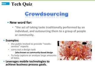
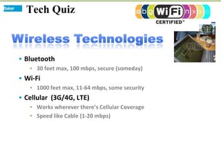
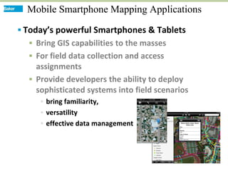
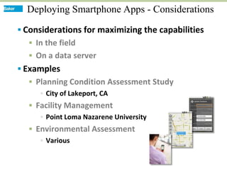
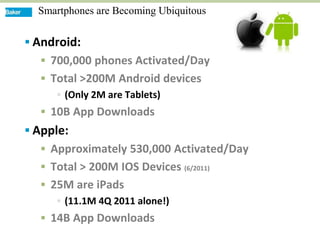
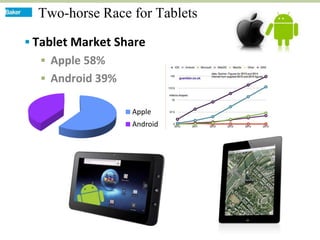
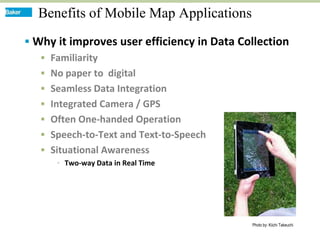
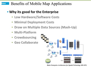
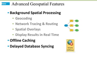
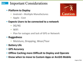
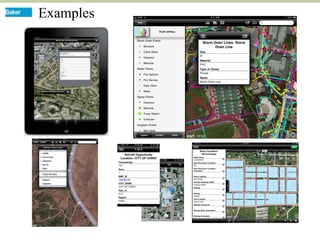
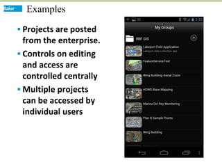
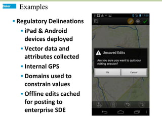
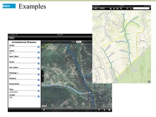
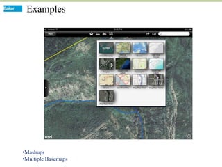
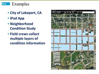
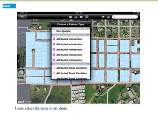
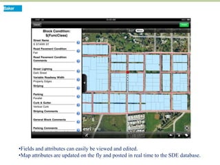
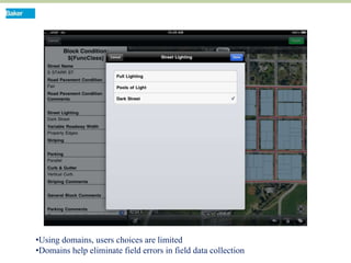
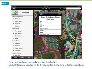
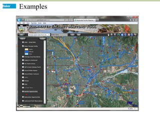
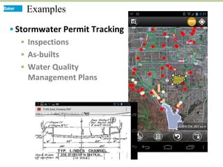
Creating Value …


                                       … Delivering Solutions

            Effective Data Collection and Management
                    through Mobile Phone Applications
                                      Steve Bein PE, GISP
Tech Quiz


   New word for:
      “the act of taking tasks traditionally performed by an
       individual, and outsourcing them to a group of people
       or community.
 Examples:
    the public invited to provide “needs-
     service” reports
    carry out a design task
        (also known as community-based design
    To help capture or analyze large amounts
     of data.
 Leverages mobile technologies to
 achieve business process goals.
Tech Quiz


 Bluetooth
    30 feet max, 100 mbps, secure (someday)
 Wi-Fi
    1000 feet max, 11-64 mbps, some security
 Cellular (3G/4G, LTE)
    Works wherever there’s Cellular Coverage
    Speed like Cable (1-20 mbps)
Tech Quiz
Tech Quiz


 Applications and services
  offered over the Internet
 Data centers can be
  anywhere in the world
 Users can share information
  between multiple systems
  and with other users.
Mobile Smartphone Mapping Applications

 Today’s powerful Smartphones & Tablets
   Bring GIS capabilities to the masses
   For field data collection and access
    assignments
   Provide developers the ability to deploy
    sophisticated systems into field scenarios
      bring familiarity,
      versatility
      effective data management
Deploying Smartphone Apps - Considerations

 Considerations for maximizing the capabilities
   In the field
   On a data server
 Examples
   Planning Condition Assessment Study
      City of Lakeport, CA
   Facility Management
      Point Loma Nazarene University
   Environmental Assessment
      Various
Smart Phone Market Share Q4 2010


                  Tablets not included
                  Symbian and Windows
                   Phone OS future?
                  Android fragmentation
                   among manufacturers
Smartphones are Becoming Ubiquitous


 Android:
   700,000 phones Activated/Day
   Total >200M Android devices
      (Only 2M are Tablets)
   10B App Downloads
 Apple:
   Approximately 530,000 Activated/Day
   Total > 200M IOS Devices (6/2011)
   25M are iPads
      (11.1M 4Q 2011 alone!)
   14B App Downloads
Two-horse Race for Tablets

 Tablet Market Share
   Apple 58%
         Sales
   Android 39%

                  Apple
                  Android
Benefits of Mobile Map Applications
 Why it improves user efficiency in Data Collection
    Familiarity
    No paper to digital
    Seamless Data Integration
    Integrated Camera / GPS
    Often One-handed Operation
    Speech-to-Text and Text-to-Speech
    Situational Awareness
       Two-way Data in Real Time


                                            Photo by: Kiichi Takeuchi
Benefits of Mobile Map Applications

 Why its good for the Enterprise
   Low Hardware/Software Costs
   Minimal Deployment Costs
   Draw on Multiple Data Sources (Mash-Up)
   Multi-Platform
   Crowdsourcing
   Geo Collaborate


                         Baker Enterprise Architecture for Spatial Technology (BEAST)
Advanced Geospatial Features

 Background Spatial Processing
   Geocoding
   Network Tracing & Routing
   Spatial Overlays
   Display Results in Real Time
 Offline Caching
 Delayed Database Syncing
Important Considerations
 Platform to Deploy
     Android – Multiple Manufactures
     Apple - Cost
 Expects Users to be connected to a network
    3G/4G
    WiFi
    Plan for outages and lack of GPS or Network
 Ruggedness
    Moisture, Dropping, Wear/Tear
 Battery Life
 GPS Accuracy
 Offline Caching more Difficult to Deploy and Operate
 Know when to move to Custom Apps or ArcGIS Mobile
                                                         Image by: Ptuffs
Examples
Examples

 Projects are posted
  from the enterprise.
 Controls on editing
  and access are
  controlled centrally
 Multiple projects
  can be accessed by
  individual users
Examples
 Regulatory Delineations
   iPad & Android
    devices deployed
   Vector data and
    attributes collected
   Internal GPS
   Domains used to
    constrain values
   Offline edits cached
    for posting to
    enterprise SDE
Examples
Examples


•Mashups
•Multiple Basemaps
Examples
 City of Lakeport, CA
 iPad App
 Neighborhood
  Condition Study
 Field crews collect
  multiple layers of
  condition information
Users select the layer to attribute.
•Fields and attributes can easily be viewed and edited.
•Map attributes are updated on the fly and posted in real time to the SDE database.
•Using domains, users choices are limited
•Domains help eliminate field errors in field data collection
•Fields and attributes can easily be viewed and edited.
•Map attributes are updated on the fly and posted in real time to the SDE database.
Examples
Examples

 Stormwater Permit Tracking
   Inspections
   As-builts
   Water Quality
    Management Plans
Creating Value …


                                       … Delivering Solutions

            Effective Data Collection and Management
                    through Mobile Phone Applications
                                      Steve Bein PE, GISP

Effective Data Collection and Management through Mobile Phone Applications

  • 1.
    Creating Value … … Delivering Solutions Effective Data Collection and Management through Mobile Phone Applications Steve Bein PE, GISP
  • 2.
    Tech Quiz  New word for:  “the act of taking tasks traditionally performed by an individual, and outsourcing them to a group of people or community.  Examples:  the public invited to provide “needs- service” reports  carry out a design task  (also known as community-based design  To help capture or analyze large amounts of data.  Leverages mobile technologies to achieve business process goals.
  • 3.
    Tech Quiz  Bluetooth  30 feet max, 100 mbps, secure (someday)  Wi-Fi  1000 feet max, 11-64 mbps, some security  Cellular (3G/4G, LTE)  Works wherever there’s Cellular Coverage  Speed like Cable (1-20 mbps)
  • 4.
    Tech Quiz Tech Quiz Applications and services offered over the Internet  Data centers can be anywhere in the world  Users can share information between multiple systems and with other users.
  • 5.
    Mobile Smartphone MappingApplications  Today’s powerful Smartphones & Tablets  Bring GIS capabilities to the masses  For field data collection and access assignments  Provide developers the ability to deploy sophisticated systems into field scenarios  bring familiarity,  versatility  effective data management
  • 6.
    Deploying Smartphone Apps- Considerations  Considerations for maximizing the capabilities  In the field  On a data server  Examples  Planning Condition Assessment Study  City of Lakeport, CA  Facility Management  Point Loma Nazarene University  Environmental Assessment  Various
  • 7.
    Smart Phone MarketShare Q4 2010  Tablets not included  Symbian and Windows Phone OS future?  Android fragmentation among manufacturers
  • 8.
    Smartphones are BecomingUbiquitous  Android:  700,000 phones Activated/Day  Total >200M Android devices  (Only 2M are Tablets)  10B App Downloads  Apple:  Approximately 530,000 Activated/Day  Total > 200M IOS Devices (6/2011)  25M are iPads  (11.1M 4Q 2011 alone!)  14B App Downloads
  • 9.
    Two-horse Race forTablets  Tablet Market Share  Apple 58% Sales  Android 39% Apple Android
  • 10.
    Benefits of MobileMap Applications  Why it improves user efficiency in Data Collection  Familiarity  No paper to digital  Seamless Data Integration  Integrated Camera / GPS  Often One-handed Operation  Speech-to-Text and Text-to-Speech  Situational Awareness  Two-way Data in Real Time Photo by: Kiichi Takeuchi
  • 11.
    Benefits of MobileMap Applications  Why its good for the Enterprise  Low Hardware/Software Costs  Minimal Deployment Costs  Draw on Multiple Data Sources (Mash-Up)  Multi-Platform  Crowdsourcing  Geo Collaborate Baker Enterprise Architecture for Spatial Technology (BEAST)
  • 12.
    Advanced Geospatial Features Background Spatial Processing  Geocoding  Network Tracing & Routing  Spatial Overlays  Display Results in Real Time  Offline Caching  Delayed Database Syncing
  • 13.
    Important Considerations  Platformto Deploy  Android – Multiple Manufactures  Apple - Cost  Expects Users to be connected to a network  3G/4G  WiFi  Plan for outages and lack of GPS or Network  Ruggedness  Moisture, Dropping, Wear/Tear  Battery Life  GPS Accuracy  Offline Caching more Difficult to Deploy and Operate  Know when to move to Custom Apps or ArcGIS Mobile Image by: Ptuffs
  • 14.
  • 15.
    Examples  Projects areposted from the enterprise.  Controls on editing and access are controlled centrally  Multiple projects can be accessed by individual users
  • 16.
    Examples  Regulatory Delineations  iPad & Android devices deployed  Vector data and attributes collected  Internal GPS  Domains used to constrain values  Offline edits cached for posting to enterprise SDE
  • 17.
  • 18.
  • 19.
    Examples  City ofLakeport, CA  iPad App  Neighborhood Condition Study  Field crews collect multiple layers of condition information
  • 20.
    Users select thelayer to attribute.
  • 21.
    •Fields and attributescan easily be viewed and edited. •Map attributes are updated on the fly and posted in real time to the SDE database.
  • 22.
    •Using domains, userschoices are limited •Domains help eliminate field errors in field data collection
  • 23.
    •Fields and attributescan easily be viewed and edited. •Map attributes are updated on the fly and posted in real time to the SDE database.
  • 24.
  • 25.
    Examples  Stormwater PermitTracking  Inspections  As-builts  Water Quality Management Plans
  • 26.
    Creating Value … … Delivering Solutions Effective Data Collection and Management through Mobile Phone Applications Steve Bein PE, GISP