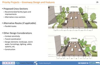
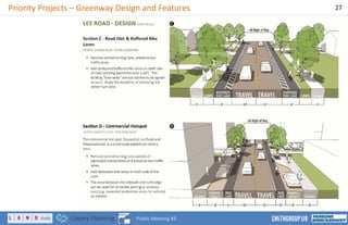
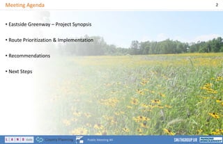
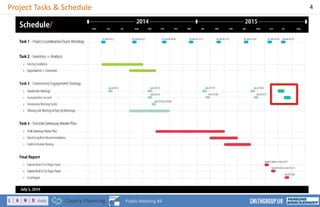
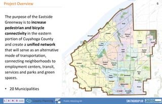
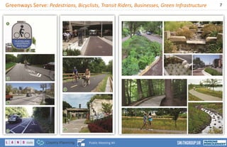
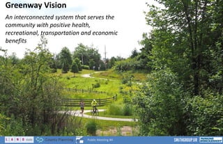
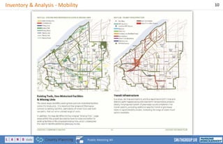
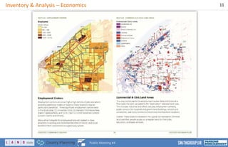
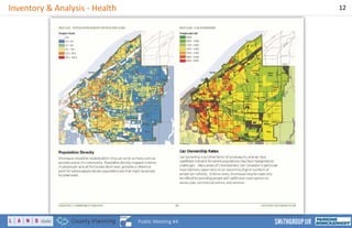
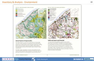
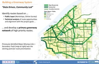
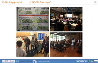
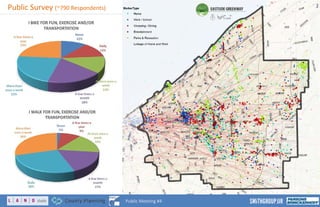
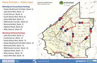
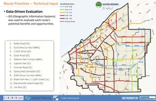
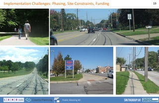
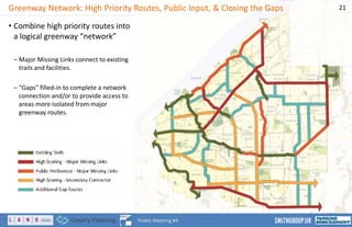
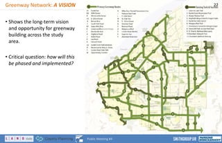
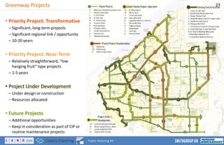
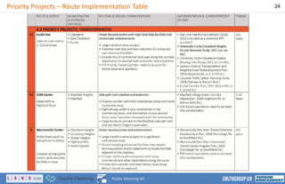
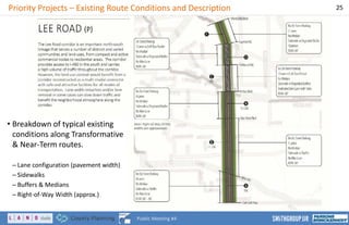
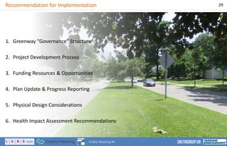
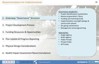
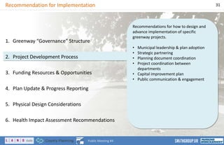
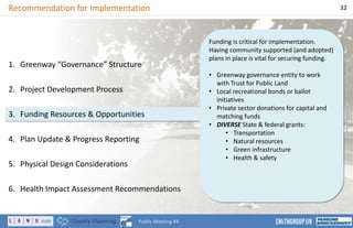
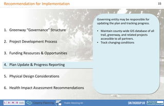
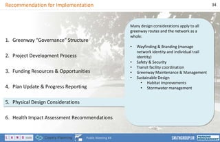
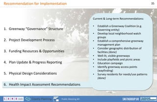
EASTSIDE GREENWAY
Cuyahoga County, East Cleveland Region
Public Meeting #4
July 21, 2015
Public Meeting #4
1
www.eastsidegreenway.weebly.com
Meeting Agenda 2
Public Meeting #4
• Eastside Greenway – Project Synopsis
• Route Prioritization & Implementation
• Recommendations
• Next Steps
Project Participants 3
Public Meeting #4
Project Team
Project Sponsors
Glenn Coyne – Cuyahoga County Planning Commission
Patrick Hewitt – Cuyahoga County Planning Commission
Jim Sonnhalter – Cuyahoga County Planning Commission
Anna Swanberg – LAND studio
Nancy Boylan – LAND studio
Joel Wimbiscus – LAND studio
Advisory Members
Ryan Noles – NOACA
Jacob Van Sickle – Bike Cleveland
Valerie Shea – RTA
Kelly Coffman – Cleveland Metroparks
Consultant Team
Neal Billetdeaux – SmithGroupJJR
Nancy Lyon-Stadler – Baker
Oliver Kiley – SmithGroupJJR
Chad Brintnall – SmithGroupJJR
Steering Committee
Municipalities
Ann Klavora – Shaker Heights
Richard Wong – Cleveland Heights
Belinda Kyle– East Cleveland
Marty Cader – Cleveland
Tina Turick – Beachwood
Jeff Pokorny – University Heights
Mayor Joseph Cicero – Lyndhurst
Steve Presley – Pepper Pike
Mayor Anthony DiCicco – Mayfield
Heights
Diane Wolgamuth – Mayfield Village
Christel Best – Richmond Heights
Keith Benjamin – South Euclid
Jeanne Lyon – Bratenahl
Marlene Kole – Highland Heights
Bob Zugan – Orange Village
Pequita Hansberry – Warrensville
Heights
Advisory Members
Melinda Bartizal / John Motl – ODOT
Stan Kosilesky – Cuyahoga County Dept. of Public Works
Marc Lefkowitz – Green City Blue Lake Institute
Kay Carlson – Nature Center at Shaker Lakes
Victoria Mills – Doan Brook Watershed Partnership
Rory Robinson – National Parks Service
Claire Posius – Cuyahoga Soil and Water Conservation District
Kathy Hexter – Cleveland State University
Elise Yablonsky – University Circle Inc.
Martha Halko – Cuyahoga County Board of Health
Kyle Dreyfuss-Wells – NEORSD
Project Tasks & Schedule 4
Public Meeting #4
Eastside Greenway Plan
A Strategic Vision to Connect Eastern Cuyahoga County
5
Public Meeting #4
Project Overview 6
Public Meeting #4
The purpose of the Eastside
Greenway is to increase
pedestrian and bicycle
connectivity in the eastern
portion of Cuyahoga County
and create a unified network
that will serve as an alternative
mode of transportation,
connecting neighborhoods to
employment centers, transit,
services and parks and green
spaces.
• 20 Municipalities
Greenways Serve: Pedestrians, Bicyclists, Transit Riders, Businesses, Green Infrastructure 7
Public Meeting #4
Greenway Vision
An interconnected system that serves the
community with positive health,
recreational, transportation and economic
benefits
8
Public Meeting #4
Greenway Goals
1. Identify a non-motorized network to provide more travel options.
• Alternative modes of transportation improve neighborhood connectivity to employment centers, transit,
services and open/recreational spaces.
2. Support economic development and reinvestment in underutilized or vacant/abandoned
properties.
• A connected non-motorized transportation network can serve to stimulate economic development and
provides an important element for coordinating land use recommendations.
3. Integrate community health considerations into preferred non-motorized recommendations.
• The Health Impact Assessment provides several recommendations organized around equity, crime/fear of
crime, social cohesion and transportation that will be incorporated into the planning process.
4. Incorporate green infrastructure into the greenway recommendations.
• Green infrastructure improves local and regional water quality, habitat connections and biodiversity.
5. Complement existing plans and initiatives to encourage collaboration between regional and
community partners.
• The Eastside Greenway planning process can serve as a tool to ensure that existing planning efforts and
initiatives are coordinated across the study area.
9
Public Meeting #4
Inventory & Analysis - Mobility 10
Public Meeting #4
Inventory & Analysis – Economics 11
Public Meeting #4
Inventory & Analysis - Health 12
Public Meeting #4
Inventory & Analysis - Environment 13
Public Meeting #4
Building a Greenway System 14
Public Meeting #4
“Data Driven, Community Led”
Identify routes based on …
• Public input (Workshops, Online Survey)
• Technical analysis of route opportunities
and alignment with the project goals …
… and develop a primary greenway
network of high priority routes.
Previously identified Major Missing Links +
Secondary Trails (map at right) was the
starting point for route prioritization.
Major Missing Links
ExistingTrails
Secondary Connectors
Open Space + Parks
CEMETERY
CONSERVATION LAND
GOLF COURSE
PARK LAND
SCHOOLS
UNIVERSITIES
Public Engagement 13 Public Meetings! 15
Public Meeting #4
Public Survey (~790 Respondents) 16
Public Meeting #4
1
7
4
Route Priorities – Public Input 17
Public Meeting #4
MetroQuest Survey Route Ranking
- Shaker Blvd/South Park Blvd (Rank: 1)
- Lake Shore Blvd (Rank: 2)
- Euclid Avenue (Rank: 3)
- South Belvoir Blvd (Rank: 4)
- Gates Mills Blvd (Rank: 5)
- SOM Center Corridor (Rank: 6)
- Monticello Blvd (Rank: 7)
- Highland Road (Rank: 8)
- Miles Avenue (Rank: 9)
Workshop #3 Route Ranking:
- Lake Shore Blvd (Rank: 1)
- Euclid Avenue (Rank : 2)
- South Belvoir Blvd (Rank : 3)
- Shaker Blvd/South Park Blvd (Rank : 4)
- Monticello Blvd (Rank : 5)
- SOM Center Corridor (Rank : 6)
- Highland Road (Rank : 7)
- Miles Avenue (Rank : 8)
- Gates Mills Blvd (Rank : 9)
2
1
3
2
4
3
55
9
6
67
5
8
9
8
Route Priorities – Technical Input
• Data-Driven Evaluation
– GIS (Geographic Information Systems)
was used to evaluate each route’s
potential benefits and opportunities.
18
Public Meeting #4
Implementation Challenges: Phasing, Site Constraints, Funding 19
Public Meeting #4
Route Prioritization & Implementation
20
Public Meeting #4
Greenway Network: High Priority Routes, Public Input, & Closing the Gaps
• Combine high priority routes into
a logical greenway “network”
– Major Missing Links connect to existing
trails and facilities.
– “Gaps” filled-in to complete a network
connection and/or to provide access to
areas more isolated from major
greenway routes.
21
Public Meeting #4
Greenway Network: A VISION
• Shows the long-term vision
and opportunity for greenway
building across the study
area.
• Critical question: how will this
be phased and implemented?
22
Public Meeting #4
Greenway Projects
• Priority Project: Transformative
– Significant, long-term projects
– Significant regional link / opportunity
– 10-20 years
• Priority Project: Near-Term
– Relatively straightforward, “low
hanging fruit” type projects
– 1-5 years
•• Project Under Development
– Under design or construction
– Resources allocated
• Future Projects
– Additional opportunities
– Keep in consideration as part of CIP or
routine maintenance projects
23
Public Meeting #4
Priority Projects – Route Implementation Table 24
Public Meeting #4
Priority Projects – Existing Route Conditions and Description 25
Public Meeting #4
• Breakdown of typical existing
conditions along Transformative
& Near-Term routes.
– Lane configuration (pavement width)
– Sidewalks
– Buffers & Medians
– Right-of-Way Width (approx.)
Priority Projects – Greenway Design and Features 26
Public Meeting #4
• Proposed Cross-Sections
– Recommended facility types and
improvements
– Alternative cross-sections
• Alternative Routes (if applicable)
– Parallel routes
• Other Design Considerations
– Context-sensitivity
– Transit coordination
– Design elements: landscape, storm
water, furnishings, lighting, safety
systems, etc.
– Construction
Priority Projects – Greenway Design and Features 27
Public Meeting #4
Recommendations & Next Steps
28
Public Meeting #4
Recommendation for Implementation 29
Public Meeting #4
1. Greenway “Governance” Structure
2. Project Development Process
3. Funding Resources & Opportunities
4. Plan Update & Progress Reporting
5. Physical Design Considerations
6. Health Impact Assessment Recommendations
Governance needed for:
• Project identification coordination
• Resource generation / focus
• Funding and matching funds
• Implementation oversight (design &
construction phase)
• On-going maintenance
• Management and programming
Approaches:
• Single-Agency
• Multi-Agency
• Public-Private
• Private-Public
• All Private
Recommendation for Implementation 30
Public Meeting #4
1. Greenway “Governance” Structure
2. Project Development Process
3. Funding Resources & Opportunities
4. Plan Update & Progress Reporting
5. Physical Design Considerations
6. Health Impact Assessment Recommendations
Recommendations for how to design and
advance implementation of specific
greenway projects.
• Municipal leadership & plan adoption
• Strategic partnering
• Planning document coordination
• Project coordination between
departments
• Capital improvement plan
• Public communication & engagement
Recommendation for Implementation 31
Public Meeting #4
1. Greenway “Governance” Structure
2. Project Development Process
3. Funding Resources & Opportunities
4. Plan Update & Progress Reporting
5. Physical Design Considerations
6. Health Impact Assessment Recommendations
Funding is critical for implementation.
Having community supported (and adopted)
plans in place is vital for securing funding.
• Greenway governance entity to work
with Trust for Public Land
• Local recreational bonds or ballot
initiatives
• Private sector donations for capital and
matching funds
• DIVERSE State & federal grants:
• Transportation
• Natural resources
• Green infrastructure
• Health & safety
Recommendation for Implementation 32
Public Meeting #4
1. Greenway “Governance” Structure
2. Project Development Process
3. Funding Resources & Opportunities
4. Plan Update & Progress Reporting
5. Physical Design Considerations
6. Health Impact Assessment Recommendations
Governing entity may be responsible for
updating the plan and tracking progress.
• Maintain county-wide GIS database of all
trail, greenway, and related projects
accessible to all partners.
• Track changing conditions
Recommendation for Implementation 33
Public Meeting #4
1. Greenway “Governance” Structure
2. Project Development Process
3. Funding Resources & Opportunities
4. Plan Update & Progress Reporting
5. Physical Design Considerations
6. Health Impact Assessment Recommendations
Many design considerations apply to all
greenway routes and the network as a
whole:
• Wayfinding & Branding (manage
network identity and individual trail
identity)
• Safety & Security
• Transit facility coordination
• Greenway Maintenance & Management
• Sustainable Design
• Habitat improvements
• Stormwater management
Recommendation for Implementation 34
Public Meeting #4
1. Greenway “Governance” Structure
2. Project Development Process
3. Funding Resources & Opportunities
4. Plan Update & Progress Reporting
5. Physical Design Considerations
6. Health Impact Assessment Recommendations
Current & Long-term Recommendations:
• Establish a Greenway Coalition (e.g.
Governing entity)
• Develop local neighborhood watch
groups
• Establish a comprehensive greenway
management plan
• Consider geographic distribution of
facilities (done)
• Well-lit, visible greenways
• Include playfields and picnic areas
• Education campaign
• Identify greenway access points
(wayfinding)
• Survey residents for needs/use patterns
(done)
Recommendation for Implementation 35
Public Meeting #4
1. Greenway “Governance” Structure
2. Project Development Process
3. Funding Resources & Opportunities
4. Plan Update & Progress Reporting
5. Physical Design Considerations
6. Health Impact Assessment Recommendations
Next Steps 36
Public Meeting #4
1. Finalize & issue report draft based
on final feedback
2. Establish a working group of
partners to oversee creation of a
governance structure for
implementing the Greenway Plan.
3. Work with local leaders and
partners to pursue plan adoption
and approval at municipal and
agency level.
4. Pursue funding and route design.

Eastside Greenway Final Presentation

  • 1.
    EASTSIDE GREENWAY Cuyahoga County,East Cleveland Region Public Meeting #4 July 21, 2015 Public Meeting #4 1 www.eastsidegreenway.weebly.com
  • 2.
    Meeting Agenda 2 PublicMeeting #4 • Eastside Greenway – Project Synopsis • Route Prioritization & Implementation • Recommendations • Next Steps
  • 3.
    Project Participants 3 PublicMeeting #4 Project Team Project Sponsors Glenn Coyne – Cuyahoga County Planning Commission Patrick Hewitt – Cuyahoga County Planning Commission Jim Sonnhalter – Cuyahoga County Planning Commission Anna Swanberg – LAND studio Nancy Boylan – LAND studio Joel Wimbiscus – LAND studio Advisory Members Ryan Noles – NOACA Jacob Van Sickle – Bike Cleveland Valerie Shea – RTA Kelly Coffman – Cleveland Metroparks Consultant Team Neal Billetdeaux – SmithGroupJJR Nancy Lyon-Stadler – Baker Oliver Kiley – SmithGroupJJR Chad Brintnall – SmithGroupJJR Steering Committee Municipalities Ann Klavora – Shaker Heights Richard Wong – Cleveland Heights Belinda Kyle– East Cleveland Marty Cader – Cleveland Tina Turick – Beachwood Jeff Pokorny – University Heights Mayor Joseph Cicero – Lyndhurst Steve Presley – Pepper Pike Mayor Anthony DiCicco – Mayfield Heights Diane Wolgamuth – Mayfield Village Christel Best – Richmond Heights Keith Benjamin – South Euclid Jeanne Lyon – Bratenahl Marlene Kole – Highland Heights Bob Zugan – Orange Village Pequita Hansberry – Warrensville Heights Advisory Members Melinda Bartizal / John Motl – ODOT Stan Kosilesky – Cuyahoga County Dept. of Public Works Marc Lefkowitz – Green City Blue Lake Institute Kay Carlson – Nature Center at Shaker Lakes Victoria Mills – Doan Brook Watershed Partnership Rory Robinson – National Parks Service Claire Posius – Cuyahoga Soil and Water Conservation District Kathy Hexter – Cleveland State University Elise Yablonsky – University Circle Inc. Martha Halko – Cuyahoga County Board of Health Kyle Dreyfuss-Wells – NEORSD
  • 4.
    Project Tasks &Schedule 4 Public Meeting #4
  • 5.
    Eastside Greenway Plan AStrategic Vision to Connect Eastern Cuyahoga County 5 Public Meeting #4
  • 6.
    Project Overview 6 PublicMeeting #4 The purpose of the Eastside Greenway is to increase pedestrian and bicycle connectivity in the eastern portion of Cuyahoga County and create a unified network that will serve as an alternative mode of transportation, connecting neighborhoods to employment centers, transit, services and parks and green spaces. • 20 Municipalities
  • 7.
    Greenways Serve: Pedestrians,Bicyclists, Transit Riders, Businesses, Green Infrastructure 7 Public Meeting #4
  • 8.
    Greenway Vision An interconnectedsystem that serves the community with positive health, recreational, transportation and economic benefits 8 Public Meeting #4
  • 9.
    Greenway Goals 1. Identifya non-motorized network to provide more travel options. • Alternative modes of transportation improve neighborhood connectivity to employment centers, transit, services and open/recreational spaces. 2. Support economic development and reinvestment in underutilized or vacant/abandoned properties. • A connected non-motorized transportation network can serve to stimulate economic development and provides an important element for coordinating land use recommendations. 3. Integrate community health considerations into preferred non-motorized recommendations. • The Health Impact Assessment provides several recommendations organized around equity, crime/fear of crime, social cohesion and transportation that will be incorporated into the planning process. 4. Incorporate green infrastructure into the greenway recommendations. • Green infrastructure improves local and regional water quality, habitat connections and biodiversity. 5. Complement existing plans and initiatives to encourage collaboration between regional and community partners. • The Eastside Greenway planning process can serve as a tool to ensure that existing planning efforts and initiatives are coordinated across the study area. 9 Public Meeting #4
  • 10.
    Inventory & Analysis- Mobility 10 Public Meeting #4
  • 11.
    Inventory & Analysis– Economics 11 Public Meeting #4
  • 12.
    Inventory & Analysis- Health 12 Public Meeting #4
  • 13.
    Inventory & Analysis- Environment 13 Public Meeting #4
  • 14.
    Building a GreenwaySystem 14 Public Meeting #4 “Data Driven, Community Led” Identify routes based on … • Public input (Workshops, Online Survey) • Technical analysis of route opportunities and alignment with the project goals … … and develop a primary greenway network of high priority routes. Previously identified Major Missing Links + Secondary Trails (map at right) was the starting point for route prioritization. Major Missing Links ExistingTrails Secondary Connectors Open Space + Parks CEMETERY CONSERVATION LAND GOLF COURSE PARK LAND SCHOOLS UNIVERSITIES
  • 15.
    Public Engagement 13Public Meetings! 15 Public Meeting #4
  • 16.
    Public Survey (~790Respondents) 16 Public Meeting #4
  • 17.
    1 7 4 Route Priorities –Public Input 17 Public Meeting #4 MetroQuest Survey Route Ranking - Shaker Blvd/South Park Blvd (Rank: 1) - Lake Shore Blvd (Rank: 2) - Euclid Avenue (Rank: 3) - South Belvoir Blvd (Rank: 4) - Gates Mills Blvd (Rank: 5) - SOM Center Corridor (Rank: 6) - Monticello Blvd (Rank: 7) - Highland Road (Rank: 8) - Miles Avenue (Rank: 9) Workshop #3 Route Ranking: - Lake Shore Blvd (Rank: 1) - Euclid Avenue (Rank : 2) - South Belvoir Blvd (Rank : 3) - Shaker Blvd/South Park Blvd (Rank : 4) - Monticello Blvd (Rank : 5) - SOM Center Corridor (Rank : 6) - Highland Road (Rank : 7) - Miles Avenue (Rank : 8) - Gates Mills Blvd (Rank : 9) 2 1 3 2 4 3 55 9 6 67 5 8 9 8
  • 18.
    Route Priorities –Technical Input • Data-Driven Evaluation – GIS (Geographic Information Systems) was used to evaluate each route’s potential benefits and opportunities. 18 Public Meeting #4
  • 19.
    Implementation Challenges: Phasing,Site Constraints, Funding 19 Public Meeting #4
  • 20.
    Route Prioritization &Implementation 20 Public Meeting #4
  • 21.
    Greenway Network: HighPriority Routes, Public Input, & Closing the Gaps • Combine high priority routes into a logical greenway “network” – Major Missing Links connect to existing trails and facilities. – “Gaps” filled-in to complete a network connection and/or to provide access to areas more isolated from major greenway routes. 21 Public Meeting #4
  • 22.
    Greenway Network: AVISION • Shows the long-term vision and opportunity for greenway building across the study area. • Critical question: how will this be phased and implemented? 22 Public Meeting #4
  • 23.
    Greenway Projects • PriorityProject: Transformative – Significant, long-term projects – Significant regional link / opportunity – 10-20 years • Priority Project: Near-Term – Relatively straightforward, “low hanging fruit” type projects – 1-5 years •• Project Under Development – Under design or construction – Resources allocated • Future Projects – Additional opportunities – Keep in consideration as part of CIP or routine maintenance projects 23 Public Meeting #4
  • 24.
    Priority Projects –Route Implementation Table 24 Public Meeting #4
  • 25.
    Priority Projects –Existing Route Conditions and Description 25 Public Meeting #4 • Breakdown of typical existing conditions along Transformative & Near-Term routes. – Lane configuration (pavement width) – Sidewalks – Buffers & Medians – Right-of-Way Width (approx.)
  • 26.
    Priority Projects –Greenway Design and Features 26 Public Meeting #4 • Proposed Cross-Sections – Recommended facility types and improvements – Alternative cross-sections • Alternative Routes (if applicable) – Parallel routes • Other Design Considerations – Context-sensitivity – Transit coordination – Design elements: landscape, storm water, furnishings, lighting, safety systems, etc. – Construction
  • 27.
    Priority Projects –Greenway Design and Features 27 Public Meeting #4
  • 28.
    Recommendations & NextSteps 28 Public Meeting #4
  • 29.
    Recommendation for Implementation29 Public Meeting #4 1. Greenway “Governance” Structure 2. Project Development Process 3. Funding Resources & Opportunities 4. Plan Update & Progress Reporting 5. Physical Design Considerations 6. Health Impact Assessment Recommendations
  • 30.
    Governance needed for: •Project identification coordination • Resource generation / focus • Funding and matching funds • Implementation oversight (design & construction phase) • On-going maintenance • Management and programming Approaches: • Single-Agency • Multi-Agency • Public-Private • Private-Public • All Private Recommendation for Implementation 30 Public Meeting #4 1. Greenway “Governance” Structure 2. Project Development Process 3. Funding Resources & Opportunities 4. Plan Update & Progress Reporting 5. Physical Design Considerations 6. Health Impact Assessment Recommendations
  • 31.
    Recommendations for howto design and advance implementation of specific greenway projects. • Municipal leadership & plan adoption • Strategic partnering • Planning document coordination • Project coordination between departments • Capital improvement plan • Public communication & engagement Recommendation for Implementation 31 Public Meeting #4 1. Greenway “Governance” Structure 2. Project Development Process 3. Funding Resources & Opportunities 4. Plan Update & Progress Reporting 5. Physical Design Considerations 6. Health Impact Assessment Recommendations
  • 32.
    Funding is criticalfor implementation. Having community supported (and adopted) plans in place is vital for securing funding. • Greenway governance entity to work with Trust for Public Land • Local recreational bonds or ballot initiatives • Private sector donations for capital and matching funds • DIVERSE State & federal grants: • Transportation • Natural resources • Green infrastructure • Health & safety Recommendation for Implementation 32 Public Meeting #4 1. Greenway “Governance” Structure 2. Project Development Process 3. Funding Resources & Opportunities 4. Plan Update & Progress Reporting 5. Physical Design Considerations 6. Health Impact Assessment Recommendations
  • 33.
    Governing entity maybe responsible for updating the plan and tracking progress. • Maintain county-wide GIS database of all trail, greenway, and related projects accessible to all partners. • Track changing conditions Recommendation for Implementation 33 Public Meeting #4 1. Greenway “Governance” Structure 2. Project Development Process 3. Funding Resources & Opportunities 4. Plan Update & Progress Reporting 5. Physical Design Considerations 6. Health Impact Assessment Recommendations
  • 34.
    Many design considerationsapply to all greenway routes and the network as a whole: • Wayfinding & Branding (manage network identity and individual trail identity) • Safety & Security • Transit facility coordination • Greenway Maintenance & Management • Sustainable Design • Habitat improvements • Stormwater management Recommendation for Implementation 34 Public Meeting #4 1. Greenway “Governance” Structure 2. Project Development Process 3. Funding Resources & Opportunities 4. Plan Update & Progress Reporting 5. Physical Design Considerations 6. Health Impact Assessment Recommendations
  • 35.
    Current & Long-termRecommendations: • Establish a Greenway Coalition (e.g. Governing entity) • Develop local neighborhood watch groups • Establish a comprehensive greenway management plan • Consider geographic distribution of facilities (done) • Well-lit, visible greenways • Include playfields and picnic areas • Education campaign • Identify greenway access points (wayfinding) • Survey residents for needs/use patterns (done) Recommendation for Implementation 35 Public Meeting #4 1. Greenway “Governance” Structure 2. Project Development Process 3. Funding Resources & Opportunities 4. Plan Update & Progress Reporting 5. Physical Design Considerations 6. Health Impact Assessment Recommendations
  • 36.
    Next Steps 36 PublicMeeting #4 1. Finalize & issue report draft based on final feedback 2. Establish a working group of partners to oversee creation of a governance structure for implementing the Greenway Plan. 3. Work with local leaders and partners to pursue plan adoption and approval at municipal and agency level. 4. Pursue funding and route design.