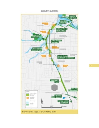
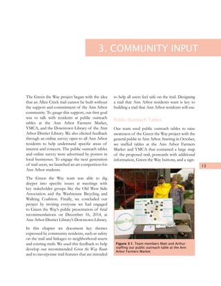
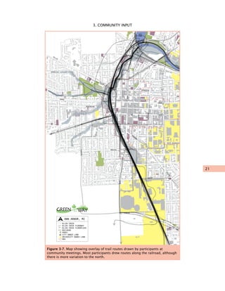
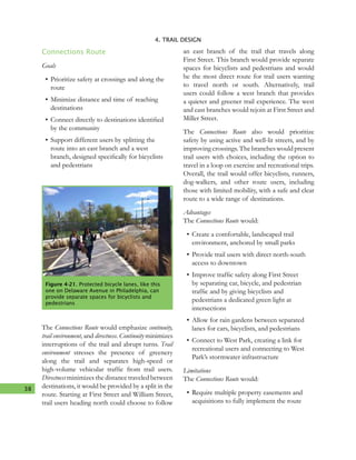
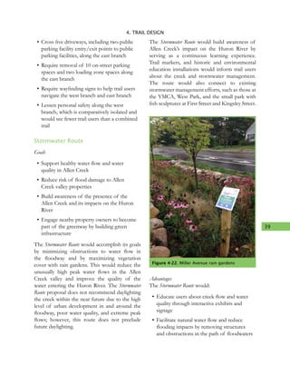
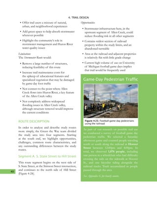
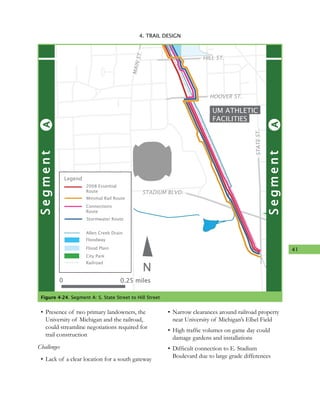
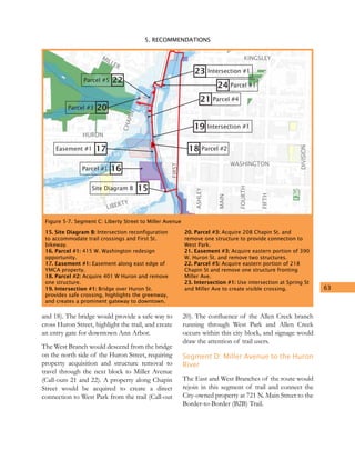
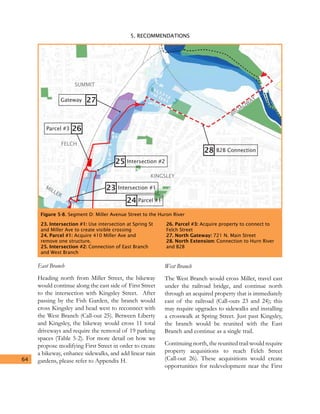
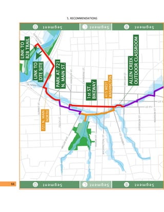
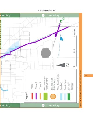
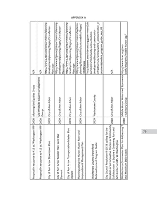
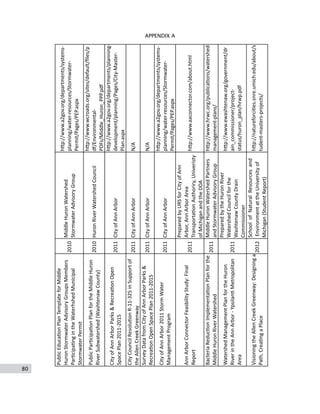
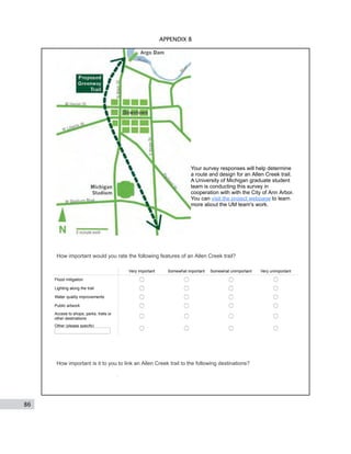
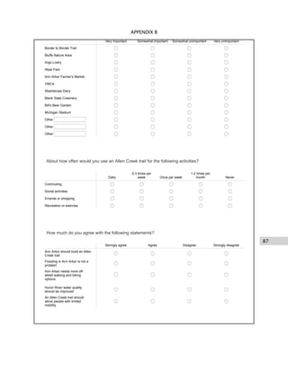
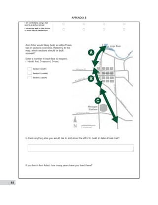
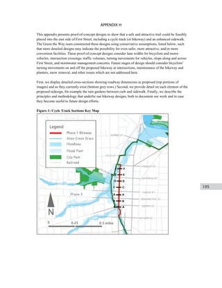
Green the Way
Moving Forward on an
Allen Creek Trail
December 19, 2014
Matt Bourke | Hannah Dean | Matt Ferris-Smith | Ashleigh Johnson
Christopher Johnson | Luke Norman | Tolu Olorode | Tricia Pontau
Arthur Prokosch | Lucas Reigstad | Pam Schaeffer | Douglas Smith
Under the direction of Larissa Larsen & Eric Dueweke
University of Michigan Urban and Regional Planning Program
Capstone Report
This page is intentionally left blank
i
GREEN THE WAY
ACKNOWLEDGEMENTS
Special thanks to Wendy Rampson and the City
of Ann Arbor for the opportunity to complete
this project and for providing knowledge and
feedback throughout. Thanks as well to the City’s
Eli Cooper, Jerry Hancock and Ethan Miller.
We would like to extend a thanks to the Allen
Creek Greenway Conservancy for their support
and enthusiasm, in particular Bob Galardi, Joe
O’Neal and Megan Barnes.
We would also like to thank the following
individuals and organizations, who provided
invaluable help and input to our project:
Robin Bailey, Ann Arbor Public Schools
Claudia Burns
Vince Caruso, Allen’s Creek Watershed Group
Steve Coron, Community High School
Mark Ferrall, Washtenaw Area Transportation
Study (WATS)
Chet Hill, Johnson Hill Land Ethics Studio
Michele Moon, Fairmount/Indigo Corridor
Collaborative (Boston, MA)
Chris Nordstrom, Johnson Hill Land Ethics
Studio
Josie Parker, Ann Arbor District Library
Laura Rubin, Huron River Watershed Council
Thank you to the Dow Sustainability Fellows
program at the Graham Sustainability Institute
for providing funding for our student art project.
We appreciate all the community members who
took time to share their thoughts on an Allen
Creek trail by stopping by our public outreach
tables, completing our survey, or attending a
community meeting on the the trail.
We thank Bethany Ramirez for her careful
reading of this report.
Lastly, we would like to extend an enthusiastic
thanks to our faculty advisors, Larissa Larsen and
Eric Dueweke, for providing excellent guidance
and leadership to our team.
ii
GREEN THE WAY
This page is intentionally left blank
iii
GREEN THE WAY
Table of Contents
M
OVING FORWARD ON
A
N
ALLEN CREEK TRAIL
heGREEN WAY
i Acknowledgements
v List of Figures & Tables
1 Executive Summary
5 Introduction
7 Background & Context
13 Community Input
23 Trail Features & Design
55 Recommendations
75 Works Cited
77 Appendices
iv
GREEN THE WAY
This page is intentionally left blank
v
GREEN THE WAY
LIST OF
FIGURES & TABLES
FIGURES
Executive Summary
Overview of the proposed Green the Way Route
Source: Green the Way
Chapter 2. Background & Context
Figure 2-1
The City’s 1988 Downtown Plan identified the
City-owned 415 W. Washington Street site as a
potential greenway park
Source: Green the Way
Figure 2-2
In 2013 the City unsuccessfully applied for
funding to create a greenway anchor park at the
721 N. Main Street site
Source: Green the Way
Figure 2-3
Flooding at Felch Street and Ashley Street in
2013. The Allen Creek valley sees frequent
floods
Source: mlive.com
Chapter 3. Community Input
Figure 3-1
Team members Matt and Arthur staffing our
public outreach table at the Ann Arbor Farmers
Market
Source: Green the Way
Figure 3-2
Green the Way’s public outreach table at the
YMCA
Source: Green the Way
Figure 3-3
Map showing where survey respondents in
Ann Arbor live. Areas in red had the highest
concentration of survey respondents.
Source: Green the Way
Figure 3-4
Map showing survey respondents’ important
destinations that should be linked to an Allen
Creek trail
Source: Green the Way
Figure 3-5
Green the Way team member Luke facilitates a
community meeting
Source: Green the Way
Figure 3-6
Washtenaw Biking and Walking Coalition
members use maps to draw potential routes and
identify important destinations
Source: Green the Way
Figure 3-7
Map showing overlay of trail routes drawn
by participants at community meetings. Most
participants drew routes along the railroad,
although there is more variation to the north.
Source: Green the Way
vi
GREEN THE WAY
Chapter 4. Trail Features & Design
Figure 4-1
Green the Way team studying route options
Source: Green the Way
Figure 4-2
Gateway parks, rail considerations, and road and
sidewalk crossings
Source: Green the Way
Figure 4-3
Two-lane path striping
Source: www.americantrails.org
Figure 4-4
Safety, traffic, and mile markers on the trail
surface
Source: www.americantrails.org
Figure 4-5
Trail signs and logos
Source: www.americantrails.org, www.
localmotion.org/ctc, bordertoborder.org
Figure 4-6
Small rain garden at Miller Avenue
Source: Green the Way
Figure 4-7
Large rain garden at the Ann Arbor YMCA
Source: Green the Way
Figure 4-8
Mission City Bike Trail next to Metrolink
commuter rail line, San Fernando, CA
Source: Rails to Trails Conservancy
Figure 4-9
Crossing gates installed beyond sidewalk edge
to block sidewalk and road, Ft. Collins, CO
Source: Google.
Figure 4-10
Fencing and gates at rail-trail crossing, Irvine,
CA
Source: Google Street View, accessed
2014.11.04.
Figure 4-11
Enhanced stop sign intersection along
Indianapolis Cultural Trail, featuring high-
visibility crosswalks and corner bump-outs
Source: ndyculturaltrail.org
Figure 4-12
A rendering of a speed table, a design solution
to increase safety where the trail crosses streets
mid-block
Source: NACTO Urban Street Design Guide
Figure 4-13
First Street and Liberty Street intersection
Source: Google.
Figure 4-14
First Street and William Street intersection
Source: Google.
Figure 4-15
Main Street and Madison Street intersection
Source: Google
Figure 4-16
Merge of on-road bicycle lane with side path
Source: Non-motorized Transportation Plan
(Full source-Appendix A) Figure 2.3L, Pg. 41
Figure 4-17
Trail emergency call light or blue light
Source: Town of Chapel Hill, accessed on
12/16/2014
Figure 4-18
Green the Way study routes
Source: Green the Way
Figure 4-19
The Allen Creek Greenway Conservancy
proposed this wide section of railroad property
be used as a park featuring a historic railroad
turntable
Source: Green the Way
vii
GREEN THE WAY
Figure 4-20
Path serving different types of users in
Madison, WI
Source: capitalbikeandwalk.org
Figure 4-21
Protected bicycle lanes like this one on
Delaware Avene in Philadelphia can provide
separate spaces for bicyclists and pedestrians
Source: thisoldcity.com
Figure 4-22
Miller Avenue rain gardens
Source: Green the Way
Figure 4-23
Football game day pedestrians using the railroad
Source: Green the Way
Figure 4-24
Segment A: S. State Street to Hill Street
Source: Green the Way
Figure 4-25
Burke-Gilman Trail near the University of
Washington
Source: www.americantrails.org
Figure 4-26
Segment B: Hill Street to Liberty Street
Source: Green the Way
Figure 4-27
Segment C: Liberty Street to Miller Avenue
Source: Green the Way
Figure 4-28
This bicycle path along the Left Hand Creek
in Boulder, CO was credited with reducing
flooding in the surrounding neighborhood
Source: www.biked.og
Figure 4-29
A cycle track (two-way protected bicycle lane)
paired with a sidewalk along the Indianapolis
Cultural Trail
Source: indyculturaltrail.org
Figure 4-30
Indianapolis Cultural Trail, a bicycle and
pedestrian path with rain gardens and local
artwork
Source: indyculturaltrail.org
Figure 4-31
Segment D: Miller Avenue to the Huron River
Source: Green the Way	
Figure 4-32
A conventional street (left) was tranformed
into a bicycle and pedestrian friendly reoute
(right) with the hlep of stormwater features in
Portland, OR
Source: www.oregonlive.com
Chapter 5. Recommendations
Figure 5-1
Overview of proposed Green the Way Route
Source: Green the Way
Figure 5-2
Segment A: S. State Street to Hill Street
Source: Green the Way
Figure 5-3
On wide railroad property through UM athletic
campus, we propose a Turntable Park in this
section of the trail
Source: Green the Way
Figure 5-4
Suggested configuration for bikeway, roads,
sidewalks, and trail at Liberty Street and First
Street
Source: Green the Way
Figure 5-5
Segment B: Hill Street to Liberty Street
Source: Green the Way
viii
GREEN THE WAY
Figure 5-6
A dedicated bicycle stoplight gives cars a red
arrow when bicyclistis and pedstrians are
crossing on the Dearborn Street cycle track in
Chicago
Source: tcsidewalks.blogspot.com
Figure 5-7
Segment C: Liberty Street to Miller Avenue
Source: Green the Way
Figure 5-8
Segment D: Miller Avenue to the Huron River
Source: Green the Way
Figure 5-9
Phasing for the Green the Way Route
Source: Green the Way
Figure 5-10
Local Motion’s bicycle ferry
Source: www.localmotion.org
Figure 5-11
Winooski River bridge, Vermont
Source: www.enjoyburlington.com
Figure 5-12
Suggested configuration for bikeway, roads,
sidewalks, and trail at Kingsley Street and First
Street
Source: Green the Way
Figure 5-13
Posters at local businesses inform residents of
public meetings
Source: Green the Way
Figure 5-14
Overhead view of the City-owned 721 N. Main
Street site. There are a number of potential
ways to connect this site to the Border-to-
Border trail.
Source: Allen Creek Greenway Task Force
Figure 5-15
Looking south along the railroad at the East
Eisenhower Parkway
Source: Green the Way
Figure 5-16
A complete Allen Creek trail will be an asset in
Ann Arbor, much like the Indianapolis Cultural
Trail has become a part of that city’s urban
environment
Source: indyculturaltrail.org
TABLES
Chapter 3. Community Input
Table 3-1
Trail activity frequency by proximity of home to
trail
Table 3-2
Trail activity frequency by household type
Table 3-3
Strengths and weaknesses of community
outreach process
Chapter 4. Trail Features & Design
Table 4-1
Study Route statistics
Table 4-2
Study Route evaluation
Chapter 5. Recommendations
Table 5-1
Green the Way Route statistics
Table 5-2
Parking spaces removed and driveways crossed
by the East Branch of the Green the Way Route
EXECUTIVE SUMMARY
Moving Forward on an Allen Creek Trail shares
routing, design, and phasing recommendations
for a proposed biking and walking trail in the
City of Ann Arbor, Michigan. The trail would
connect community destinations while providing
attractive green space and enhanced stormwater
management. The trail would also be an
opportunity to improve one of the city’s defining
natural features, Allen Creek, which was buried
in 1926 and has been badly polluted for over 100
years. Increased flooding and persistent pollution
in Allen Creek, alongside a greater awareness
of stormwater management, has created a new
urgency for creative solutions like an Allen Creek
trail.
This idea is not new. First mention of an Allen
Creek trail emerged in the City’s 1981 Plan for
Park, Recreation, and Open Space, and the idea
gained momentum in the early 2000s. Although
no precise alignment of the trail has been chosen,
efforts have focused on the Allen Creek valley
and the active railroad corridor that runs through
it. The railroad and the creek are closely aligned
but follow separate paths at Miller Avenue, where
the creek bends northeast towards the Huron
River, presenting options for trail routing.
The Green the Way project team consists of
12 Master of Urban Planning students and two
faculty members, whose aim it was to develop
detailed recommendations for an Allen Creek
trail. It has been a collaborative effort between
the University of Michigan’s Taubman College
of Architecture and Urban Planning, the City
of Ann Arbor, and the Allen Creek Greenway
Conservancy. To create the recommendations,
the Green the Way team followed a three-step
process, with each step informing the next:
•	Reviewed 65 existing documents and plans
relevant to an Allen Creek Trail.
•	Engaged the Ann Arbor community
through an online survey (600+ responses),
seven community meetings, 38 hours at a
mobile information station, and a youth art
ideas competition.
•	Created trail routing options, evaluated
their trade-offs, and identified next steps
towards implementing an Allen Creek trail.
Our analysis reveals a wide range of motivations
for an Allen Creek trail, including facilitating
recreational and commuter use, connecting
neighborhoods and downtown, mitigating
flooding and stormwater issues, and enhancing
quality of life. To explore the trade-offs
between these interests we compared a route
previously created by the Allen Creek Greenway
Conservancy and three unique new routes
created by the Green the Way team:
1
2
EXECUTIVE SUMMARY
The 2008 Essential Route would provide a
basic route along the railroad. This study
route is based on a proposal developed by
the Allen Creek Greenway Conservancy.
The Minimal Rail Route would follow the
north-south orientation of the railroad
while minimizing use of railroad private
property.
The Connections Route would focus on non-
motorized travel to destinations between
the Huron River, downtown and the south
end of the University of Michigan athletic
campus, connecting users to identified
destinations.
The Stormwater Route would prioritize
stormwater and flooding issues in the
Allen Creek Valley. This route deviates
from the rail corridor near Kingsley Street
and follows the Allen Creek floodway to
the Huron River.
The best features of these four routes, in
combination with our document review and
community engagement, informed our final
recommended route: the Green the Way Route. This
trail option features stormwater infrastructure,
educational opportunities, a new pedestrian and
bicycle bridge, and connections to community
identified destinations, including the Border-to-
Border Trail, Michigan Stadium, and downtown.
Developing an Allen Creek trail presents
challengesforthecity,theUniversityof Michigan,
the railroad, businesses, and private property
owners; however, if constructed, it would be an
asset for generations to come, and its true legacy
would be realized through a healthier community
and improved environment. The Green the Way
team recommends that this trail be implemented
in three phases. As residents begin using
completed parts of the trail, momentum to finish
the greenway and connect it to other destinations
will grow.
3
EXECUTIVE SUMMARYGreen the Way
DOWNTOWN
KERRYTOWN/
OLD 4th WARD
WATER HILL
UM CENTRAL
CAMPUS
UM ATHLETIC
FACILITIES
Huron
River
GERMANTOWN
OLD WEST
SIDE
FIRST STREET
BIKEWAY
LINK TO
WEST PARK
LINK TO
DTE SITE
LINK TO
B2B TRAIL
FUTURE SOUTH
EXTENSION
LINK TO
BURNS PARK
TURNTABLE
PARK
ALLEN CREEK
OUTDOOR CLASSROOM
BRIDGE OVER
HURON STREET
GATEWAY
RAIN GARDEN
PARK AT 721 N.
MAIN STREET
FINGERLE
SOUTH
FINGERLE
NORTH
415 WEST
WASHINGTON
227 FELCH
SOUTH
721 N. MAIN
NORTH
Green The Way trail
Park Space and
Rain Gardens
Site Redesign
Opportunity
Legend
Allen Creek Drain
Floodway
Flood Plain
City Park
Railroad
N
0 0.25 0.5 miles
SUMMIT ST.
FELCH ST.
KINGSLEY ST.
CATHERINE ST.
HURON ST.
WASHINGTON ST.
LIBERTY ST.
WILLIAM ST.
JEFFERSON ST.
MADISON ST.
HILL ST.
HOOVER ST.
MAINST.
ASHLEYST.
STADIUM BLVD.
STATEST.
1stST.
MAINST.
BROADW
AY
MILLER AVE.
SegmentSegmentSegmentSegmentAAABACAD
Overview of the proposed Green the Way Route
4
EXECUTIVE SUMMARY
This page is intentionally left blank
5
This report, Moving Forward on an Allen Creek
Trail, shares routing, design, and phasing
recommendations for a proposed trail in Ann
Arbor, Michigan. The trail, first noted in City’s
planning documents in 1981, follows Allen Creek
from the creek’s source near Michigan Stadium to
the Huron River, and could connect community
destinations while providing attractive green
space and improving stormwater management.
Local leaders and advocates have included an
Allen Creek trail in various City planning efforts,
but a master plan for the project has not been
created. The recommendations in this report are
intended to inform both of these actions, helping
Ann Arbor to move forward with an Allen Creek
trail.
The Green the Way project has been a
collaborative effort between the University of
Michigan’s Taubman College of Architecture
and Urban Planning, the City of Ann Arbor,
and the Allen Creek Greenway Conservancy.
Our team includes 12 Master of Urban Planning
students and two faculty members. In addition
to urban planning, the students belong to
programs in architecture, natural resources and
environment, public policy, and social work. The
team has worked with City staff and Conservancy
members in an effort to produce action-
oriented recommendations that are feasible and
representative of the community’s interests.
While an Allen Creek trail has been included and
discussed in documents for many years, the need
for a comprehensive plan became apparent in
2013 when an application to the Michigan Natural
Resources Trust Fund was denied. The grant
would have helped to transform the City storage
yard at 721 N. Main Street into a park along the
trail. In declining the application, reviewers noted
that the application failed to link the park project
to a larger trail plan. While a disappointment for
trail proponents, the experience highlighted the
value of having a trail master plan, and helped
lead to the Green the Way project.
To create its recommendations, the Green the
Way team followed a three-step process. First,
we reviewed 65 city plans and supplemental
documents about an Allen Creek trail in an
effort to understand the history of the idea and
the current context. Next, the team gathered
community input both in person and through
an online survey. Based on the document
review and community input, the team created
three route options, each of which pursue a
particular goal: minimizing the use of railroad
property; facilitating access to shops, trails, and
other destinations; and maximizing stormwater
management opportunities. We also adapted
a 2008 proposal by the Allen Creek Greenway
Conservancy to create a fourth study route,
which follows the railroad to the Huron River.
1. INTRODUCTION
6
1. INTRODUCTION
Finally, we selected elements from each of the
four study routes — using evaluation criteria
informed by research and community input —
to create a recommended Green the Way Route.
The Green the Way team carefully defined
the scope of our project in order to give
complex issues the attention they deserved. We
intentionally did not consider the potential costs
of our concept routes and Green the Way Route, at
the recommendation of the City. We were told
that City staff are better equipped to calculate
those estimates, and that identifying a route
would need to precede cost estimates. We also
chose to not make specific recommendations for
the three city-owned properties at 721 N. Main
Street, 415 W. Washington Street, and the First
Street and William Street site. Instead, we refer to
the designs that previous planning efforts have
created for these sites.
This report is divided into four additional
chapters. Chapter 2 provides context for the
project, including information on the history
of trail efforts and our summary of previous
documents related to the trail. Chapter 3
describes our community engagement process
and summarizes the input we received. Chapter
4 introduces and analyzes the four study routes
after describing features common to all routes.
Chapter 5 details the Green the Way Route,
proposes phasing for trail development, and
makes recommendations on other next steps.
Appendices to the report contain supplemental
technical and reference material.
7
One of the first tasks undertaken by the Green
the Way team was a document review of previous
work concerning Allen Creek and an Allen Creek
trail. This review increased our familiarity with
the project, informed our understanding of the
motivations behind thetrail, and helpedshape our
approach to trail routing. This chapter reviews
and summarizes the history of the Allen Creek
greenway trail from several planning documents
created by the City of Ann Arbor, previous
University of Michigan master’s projects, and
rails with trails studies, to name a few. These
documents track the evolution of the project
over time, which aided in our identification of
key points for our project. See Appendix A for a
list of the documents reviewed.
History
The first published mention of an Allen Creek
greenway appeared in the City of Ann Arbor’s
1981 Plan for Park, Recreation and Open Space. This
plan recommended developing pathways along
a number of drains through the city, including
Allen Creek. This same plan also recommended
converting a few downtown sites into parks,
including the City-owned site at First Street and
William Street.
The City’s 1988 Downtown Plan connected the
ideas of a pathway along the Allen Creek and
downtown park development, into a single
“greenway” concept (p.54). One of the plan’s
objectives was to “foster the development of a
system of open spaces on the floor of the Allen
Creek Valley” that were “linked by on-street
walkways” (p.54-55). The plan also suggested
that the City-owned properties at First and
William and 415 W. Washington Street could
serve as greenway parks.
An Allen Creek greenway was subsequently
mentioned in the City’s Park, Recreation and
Open Space Plans in 1988, 1994 and 2000. In
2004 the City began to explore an Allen Creek
greenway in earnest, starting with an appointed
Allen Creek Greenway Committee on the Park
Figure 2-1. The City’s 1988 Downtown Plan
identified the City-owned 415 W. Washington
property as a potential greenway park
2. CONTEXT &
BACKGROUND
8
2. CONTEXT & BACKGROUND
Advisory Commission (PAC). This committee
interviewed stakeholders, conducted research,
and ultimately recommended that the City
dedicate three City-owned parcels (721 N. Main
Street, 415 W. Washington, and First and William)
to the greenway. In addition, the committee
recommended that the floodway portion of
each site be dedicated as open space, and the
floodplain portion of each site “be held by the
City for uses in the public interest.” (ACG Task
Force, 2007, p. 13) With this in mind, the City
recognized the flood mitigation potential of a
greenway. The PAC’s Greenway Committee also
recommended a “paved pedestrian/bicycle path
that would roughly parallel the route of the Ann
Arbor railroad tracks” (ACG Task Force, 2007).
While the City contemplated a greenway, citizen
groups also joined in the effort. Groups like
Friends of the Ann Arbor Greenway, the Allen
Creek Greenway Study Group, and later the non-
profit Allen Creek Greenway Conservancy began
investigating and advocating for a greenway
beginning in the mid-2000s.
In 2005 the City took its biggest step towards a
greenway, appointing the Allen Creek Greenway
Task Force to explore a greenway along Allen
Creek. The Task Force focused on how to
develop the three city-owned parcels mentioned
in previous plans. Their work resulted in an
80+ page report with a 650+ page appendix,
completed in 2007. Many hoped that the Task
Force’s report would spark the beginning of work
on a greenway. While the economic recession of
2008 stalled official progress, the Allen Creek
Greenway Conservancy continued their efforts
and proposed a specific route for a greenway that
followed the railroad corridor.
In 2012, a group of master’s students from the
School of Natural Resources and Environment
at the University of Michigan produced a report
that further investigated a greenway along
Allen Creek. Building off the work of the Task
Force and the Conservancy, this student group
investigated where to site a path to form the spine
of a greenway. They followed the Conservancy’s
2008 recommendation to locate the path along
railroad property.
In the years after the Task Force’s report, with
no substantial progress made on a greenway,
the City made efforts to keep the greenway idea
alive. A 2010 City Council resolution expressed a
desire to develop the 415 W. Washington parcel
as a greenway anchor park. The City Council
passed another resolution in 2011 expressing full
support for an Allen Creek greenway.
The City again took concrete steps towards
a greenway in 2013, centered on turning the
decommissioned 721 N. Main Street site into an
anchor park for a greenway. In the early part of
2013, the City secured a FEMA hazard mitigation
Figure 2-2. In 2013, the City applied unsuccessfully for funding to turn the 721 N. Main property into
an anchor park for a greenway trail
9
2. CONTEXT & BACKGROUND
grant to demolish two storage structures at the
721 N. Main Street property. Later that year, the
City applied for a Michigan Natural Resources
Trust Fund (MNRTF) grant to develop the 721
N. Main Street site “as the first part of the Allen
Creek Greenway.” As part of this application,
the City secured $150,000 in matching funds
from Washtenaw County Parks and Recreation
Commission’sConnectingCommunitiesprogram
for the project. The MNRTF grant application
detailed the development of the 721 N. Main
Street site, building off of the work of the City’s
North Main Vision Task Force. The application
also described how the project site and trail
would connect to the existing Border-to-Border
(B2B) Trail network. When the City’s application
was denied, reviewers noted that the City failed
to link the 721 N. Main Street site development
to a larger trail plan. In response, the City and the
Allen Creek Greenway Conservancy decided that
pursuing a comprehensive plan for the greenway
was a necessary step forward.
Past and Present Planning for an Allen
Creek Trail
As part of our research we reviewed 65
documents related to an Allen Creek trail.
These include the City’s Allen Creek Greenway
Task Force Report (2007); Visioning the Allen
Creek Greenway (2012), written by master’s
students in the School of Natural Resources and
Environment at the University of Michigan; Ann
Arbor’s Master Plan, Capital Improvements Plan,
and City Code; additional stormwater, watershed,
and transportation plans; and site assessments
and proposals. While previous proposals have
referred to the project as a “greenway,” we have
adopted the plainer term “trail” in an effort to
reduce confusion. We have divided the content
of these documents into six categories: Trail
Location and Design, Adjacent Properties
and Trail Crossings, Stormwater Management,
Neighborhood Connections and Input, Rails and
Transit, and Funding Opportunities.
Trail Location and Design
The existing approaches for greenway
development can be divided into 1) approaches
that place a greenway trail exclusively along the
railroad corridor and 2) plans advancing the
development of particular sites, especially City-
owned parcels that lie within the Allen Creek
floodway. Despite several past planning efforts,
only the Allen Creek Greenway Conservancy
document Proposed Route of the Allen Creek
Greenway (2008) proposed a specific and detailed
location for the trail. This route followed the
railroad as opposed to the Allen Creek. The
Visioning the Allen Creek Greenway (2012) report
also investigated trail routing, but did not provide
enough detail to be fully considered.
Past plans proposed dividing a trail into
segments and implementing it in phases. The
City’s Downtown Plan (2009) divides a trail based
on the distinctive character of the adjacent areas:
the South Campus Athletic area, the Downtown
commercial/residential area, and the North Main
residential/industrial mix. Visioning the Allen
Creek Greenway (2012) similarly divides a trail into
three segments. The Preliminary Feasibility Study
(2005), created at the University of Michigan’s
Ross School of Business, divides a trail into two
design stages that are contingent on construction
costs and land acquisition within the Ann Arbor
Railroad’s property. The first stage would follow
the railroad from end to end, while the second
stage would deviate from the railroad and cross
over the floodway at the 721 N. Main site, leading
to Wheeler Park and eventually connecting to the
B2B Trail at the DTE site via a new underpass.
Only the Ross report evaluated grading and
construction costs, along with costs associated
with an elevated trail adjacent to the railroad
berm north of Liberty Street.
10
2. CONTEXT & BACKGROUND
The City of Ann Arbor has studied possible
connections between the 721 N. Main Street site
and the B2B Trail, but solutions have proven
difficult. The City submitted a Michigan Natural
Resources Trust Fund Grant Application (2013)
to fund the first part of the trail, but it was
rejected; the grant proposed looped paths at 721
N. Main Street, linking Felch Street, N. Main
Street, and Summit Street and identified several
potential connections to the B2B Trail. The City
also commissioned the Allen Creek Berm: Feasibility
of Flood Reduction and Pedestrian Options (2013)
report, which investigated several initiatives that
could help connect 721 N. Main Street to the
B2B Trail. The study recommends installing two
parallel culverts underneath the railroad berm,
one for the Allen Creek floodway and another
for pedestrians and bicyclists, connecting Depot
Street and the DTE site for an estimated cost of
$3.9 million. In addition to pedestrain and bicycle
links this project could dramatically reduce the
Allen Creek floodplain.
Adjacent Properties and Trail Crossings
According to the Parks & Recreation Open Space
Plan2011-2015,thedowntownareahasashortage
of open space relative to the rest of the city. This
limitsbothrecreationalandstormwatermitigation
opportunities. Incorporating downtown and city-
owned parcels into a greenway trail could help
alleviate these problems.
The City’s Downtown Plan (2009) sets a goal
of reinforcing the stability of the residential
neighborhoods surrounding downtown through
incremental transitions including intermediate-
scale residential development. According to
the Downtown Plan, a greenway could act as an
identifiable boundary between downtown and
adjacent neighborhoods, buffering adjacent uses
with “step-down” development (e.g., medium-
density mixed-income housing). From an
infrastructure improvement point-of-view, the
City’s Non-motorized Transportation Plan (2007, with
update 2013) and the corresponding section of
the Capital Improvements Plan 2014-2019 identify
design principles, funding, and sequencing for
creating safe mid-block non-motorized crossings
that would accommodate trail users and stitch
together neighborhoods across the rail line. The
City has identified railroad crossings at Liberty
Street, Huron Street, and Miller Avenue as
potential major mid-block crossings; Hill Street
and Hoover Street are identified as potential
minor mid-block crossings.
Finally, City plans propose that three city-
owned parcels (415 W. Washington, First and
William, and 721 N. Main Street) serve as major
anchor sites along a trail. Each site has soil
contamination and/or building deterioration
issues. As stated in the Allen Creek Greenway
Task Force’s Report (2007), redevelopment for
an Allen Creek greenway project must consider
additional brownfield mitigation costs.
Stormwater Management
The Allen Creek valley is one of Ann Arbor’s
defining natural features. While the creek is now
enclosedinapipebeneaththeground,itsnorthern
most two miles are significantly impaired, and
those living in this area experience flash flooding
and poor water quality. The Stormwater Model
Calibration and Analysis Preliminary Results and
Recommendations (2014) found the Lower Allen
Creek has the most frequent and severe flooding
in the City. As stated in the Watershed Management
Plan for the Huron River (2011), the Creek’s culverts
and drains are undersized; this often causes
flooding that endangers the 707 properties
within the 100-year floodplain. According to the
Allen Creek Greenway Task Force’s Report (2007)
and the City’s Flood Mitigation Plan (2007), 100%
of National Flood Insurance Program claims
from Ann Arbor have originated from properties
within one quarter mile of Allen Creek. Based
11
2. CONTEXT & BACKGROUND
on water samples, the amount of nutrients
(phosphorus, nitrates, nitrites), suspended solids
(sediment), and pathogens (E. coli) in this water
exceed the City’s new Stormwater Calibration Model
and federal water quality guidelines. Ranked
by the Model as the top area of flood risk and
poor water quality in the City, expanding green
space and integrating the best stormwater
management practices along an Allen Creek trail
would demonstrate Ann Arbor’s commitment to
progressive water management.
Neighborhood Connections and Input
Community engagement directly and indirectly
related to Allen Creek has been going on for
over 10 years through citizen advisory groups,
public meetings, interviews, and surveys. While
individual comments vary, there is broad support
for a greenway. Community engagement is
important in creating an Allen Creek trail because
of the trail’s potential to connect different land
uses, including residential neighborhoods,
commercial centers, parks, and institutional
activities (for example at the University of
Michigan’s athletic facilities). The vision that
emerged from the public input process of the
North Main-Huron River Task Force Report (2013)
was for an Allen Creek corridor that increases
connections between the above destinations,
while being a recreational destination in itself.
The Task Force’s Report (2007) and Visioning the
Allen Creek Greenway (2012) identified two key
neighborhood stakeholders: the Downtown
Development Authority (DDA) and the
University of Michigan. These two stakeholders,
in addition to the City and the owner of the Ann
Arbor Railroad, could benefit from the creation
of a trail along Allen Creek. For the DDA, a
trail would help form a transition between the
residential and commercial areas, while adding
recreational and green space to downtown.
According to the Visioning (2012) report, UM’s
involvement would form “part of the critical
first step” that would make the creation of the
trail viable in Ann Arbor.
Rail and Transit
Trails along rail corridors invariably raise safety
and liability issues for railroad owners. The U.S.
Departmentof Transportation’s(USDOT)report,
Rails-with-Trails: Lessons Learned (2002), found that
accidents between trains and pedestrians are less
frequent when closed fencing separates a trail
from the rail. The Ann Arbor Railroad is a major
thoroughfare for fans traveling to the game on
football Saturdays, posing major liability issues
for the rail owner (WATCO). A designated trail
could help decrease rail trespassing. In addition,
the USDOT report suggests that the liability of
pedestrians using a trail could be shifted to the
City through indemnification agreements, which
could entice WATCO to support the Allen Creek
trail.
Although the Ann Arbor railroad is currently
used for infrequent short-line services (local
line-haul railroads), proposed commuter projects
could increase its use, which will increase the
need for pedestrian safety. The North/South
Figure 2-3. Flooding at Felch Street and Ashley
Street in 2013. The Allen Creek valley sees
frequent floods.
12
2. CONTEXT & BACKGROUND
Commuter Rail (WALLY) project’s evaluation
of downtown Ann Arbor station sites proposes
eight commuter trains daily, connecting Howell
to a proposed downtown station located between
Washington Street and Liberty Street. Meanwhile,
the AAATA is exploring six corridor options for
local transit service known as the Ann Arbor
Connector. One route would follow the railroad
property starting at Madison Street and proceed
south for 1.75 miles, thus complicating the trail’s
potential location within this stretch of the route.
Funding
Constructing an Allen Creek trail would most
likely require a combination of funding sources
that could necessitate phased implementation.
The Allen Creek Greenway Task Force’s Report
(2007) reviewed funding options for a greenway
trail. It suggested that funding requirements
fall into three categories: land acquisition and
easements, park and trail development, and on-
going management and maintenance. Locally,
a source of one time funds could be the
time-limited 2004 Open Space and Parkland
Preservation millage. Commonly known as the
Greenbelt Millage, one-third of these funds
are targeted for land acquisition. Other local
funds might include mitigation funds from new
development or a capital improvement millage.
TheRossSchoolStudy(2005)alsoidentifiedmany
potential funding sources, recommending the
BrownfieldTIFandtheDowntownDevelopment
Authority TIF as the most promising options.
The study also identified numerous funding
sources from the Michigan Department of
Environmental Quality, the U.S. Department
of Housing and Urban Development, the
Federal Emergency Managment Agency, the
Michigan Department of Transportation, and
local government. Many of these are targeted at
watershed improvements, trails, and brownfield
development. Other possible sources of funding
include local foundation support for capital costs,
nonprofit and/or local business support for
operating costs, and Michigan Department of
Natural Resources trail funding. These funding
sources should be revisited due to the time that
has elapsed since the studies were written.
Conclusion
Afterreviewing65cityplansandotherdocuments
concerning an Allen Creek greenway, several key
findings emerge. We determined that only in
the Allen Creek Greenway Conservancy’s 2008
report was a detailed route for the path identified.
In general the approaches for thinking about trail
alignment fall into two categories: exclusively
following the railroad corridor, or deviating
from the railroad in downtown to follow Allen
Creek to the Huron River. In all routes a portion
of a trail will be adjacent to the railroad, which
raises safety and liability concerns. The U.S.
Department of Transportation offers guidelines
that include physical design interventions, such
as fences, and model indemnification agreements
to reduce the railroad’s liability concerns. Several
plans suggest phasing the implementation of
the project, and two plans divide the length
of a trail into three distinct segments: South
Campus/ Stadium, Downtown, and Residential/
Industrial Mix of North Main. Within Ann
Arbor’s Master Plan, the Parks & Recreation Open
Space Plan 2011-2015 noted the shortage of
open space in downtown, and the Downtown Plan
(2009) suggested that a trail could form a needed
buffer between the downtown core and the
residential Old West Side neighborhood. From
a stormwater perspective, the project could
address water quality and quantity problems,
directly and through education. Together, these
issues and plans framed our efforts as we sought
community input and compared potential routes.
13
3. COMMUNITY INPUT
The Green the Way project began with the idea
that an Allen Creek trail cannot be built without
the support and commitment of the Ann Arbor
community. To gauge this support, our first goal
was to talk with residents at public outreach
tables at the Ann Arbor Farmers Market,
YMCA, and the Downtown Library of the Ann
Arbor District Library. We also elicited feedback
through an online survey open to all Ann Arbor
residents to help understand specific areas of
interest and concern. The public outreach tables
and online survey were advertised by posters in
local businesses. To engage the next generation
of trail users, we launched an art competition for
Ann Arbor students.
The Green the Way team was able to dig
deeper into specific issues at meetings with
key stakeholder groups like the Old West Side
Association and the Washtenaw Bicycling and
Walking Coalition. Finally, we concluded our
project by inviting everyone we had engaged
to Green the Way’s public presentation of final
recommendations on December 16, 2014, at
Ann Arbor District Library’s Downtown Library.
In this chapter we document key themes
expressed by community residents, such as safety
on the trail and linkages to neighborhood assets
and existing trails. We used this feedback to help
develop our recommended Green the Way Route
and to incorporate trail features that are intended
to help all users feel safe on the trail. Designing
a trail that Ann Arbor residents want is key to
building a trail that Ann Arbor residents will use.
Public Outreach Tables
Our team used public outreach tables to raise
awareness of the Green the Way project with the
general public in Ann Arbor. Starting in October,
we staffed tables at the Ann Arbor Farmers
Market and YMCA that contained a large map
of the proposed trail, postcards with additional
information, Green the Way buttons, and a sign-
Figure 3-1. Team members Matt and Arthur
staffing our public outreach table at the Ann
Arbor Farmers Market
14
3. COMMUNITY INPUT
up sheet for members of the public to receive
additional updates on the project and online
survey. Green the Way team members engaged
with the public for 34 hours over five days at
the Farmers Market and for four hours over two
days at the YMCA. During this time, we solicited
feedback and answered questions from over 160
people. In addition to our staffed outreach tables,
we set up a standalone information table at the
Downtown Library of the Ann Arbor District
Library.
The Green the Way team gathered feedback at
these public outreach tables on issues like trail
use, safety, and access to destinations. This
feedback helped us define and evaluate different
study routes and trail configurations. The
conversations at these tables also helped us to
identify community and neighborhood groups to
contact.
Key findings from our conversations at
public outreach tables include:
•	Ann Arbor residents and visitors expressed
a strong interest in building a trail in this
corridor, especially if it were safe and
comfortable.
◦◦ While the majority of the people we
talked to supported the plan, some
were concerned with implementation,
specifically when the trail would get built,
and how much it would cost.
•	The highest interest destinations were
recreational facilities along the Huron
River, especially the Border-to-Border Trail.
◦◦ Residents that lived near the trail were
particularly interested in reaching
downtown.
•	The greatest interest in trail use was for
recreation, followed by commuting, dog-
walking, and accessing destinations.
•	Some residents and visitors were
particularly excited to have a safe space
to bike with children, along a trail that
would be separated from street traffic. One
resident remarked that a lack of protected
bikeways currently makes Ann Arbor
“starkly different from Madison.”
•	Some residents were particularly interested
in providing green space downtown and
highlighting natural features like the Allen
Creek.
◦◦ A few residents hoped to daylight the
creek, opening up storm sewers and
reconstructing the creek.
Survey
The Green the Way team gathered feedback
about trail preferences through an online survey.
In a five-week period, 609 residents responded
with 520 completed surveys. The survey was
open to all members of the public.
To encourage residents to complete the survey,
we distributed posters to over 50 Ann Arbor
businesses to place on windows and community
Figure 3-2. Green the Way’s public outreach
table at the YMCA
15
3. COMMUNITY INPUT
boards. The Green the Way team also placed
posters in university buildings, including the
Michigan Union and the Central Campus
Recreation Building, to encourage students to
participate.
The survey contained seven questions about
the trail and three questions about respondents’
demographics, including years lived in Ann
Arbor, number and age of household members,
and the intersection closest to their home. For
the purposes of analysis, we approximated
respondents’ distance from an Allen Creek
trail using the existing railroad line; as a result,
“distance from trail” is synonymous with
“distance from railroad.” Survey respondents
chose from predefined options for all but one of
the survey questions. In addition to completing
the survey, 182 respondents provided their email
addresses and were invited to Green the Way’s
final presentation. See Appendices B and C for
survey questions and responses.
Most respondents (64 percent) indicated that
they live more than half a mile from the trail.
The specific areas with the highest number of
respondents were, in order: the Old West Side,
Kerrytown, and Burns Park near Packard Street
and E. Stadium Boulevard. Twenty-two percent
of respondents indicated that they live in a
household with at least one child aged fifteen or
younger. At the opposite end of the spectrum,
23 percent of respondents live in households
with at least one person aged 61 or older. The
average respondent had lived in Ann Arbor for
21 years, with a range of three months to 70
years of residence in the City.
A majority of respondents were familiar with
the idea of an Allen Creek trail, with 64 percent
reporting that they are familiar or very familiar
with the project. Some respondents may have
been familiar with an Allen Creek trail only
because of their interactions with us at public
outreach tables and community meetings. We
encouraged both of these groups of people to
take our survey, and the survey did not track
other involvement with Green the Way project
efforts.
The survey sought feedback about three main
items related to the trail: routing, design, and
implementation. This included specific questions
on trail features, such as lighting and artwork.
Other questions focused on preferences relating
to a potential trail—such as concerns about
flooding, willingness to walk farther to avoid
difficult intersections, and individuals’ comfort
level around active railroads.
0 0.25 0.5 miles
N
DOWNTOWN
KERRYTOWN/
OLD 4th WARD
WATER HILL
UM CENTRAL
CAMPUS
Huron
River
GERMANTOWN
OLD WEST
SIDE
UM ATHLETIC
FACILITIES
BURNS PARK
HuronRiver
Rail
Huron River
0
204
Survey Respondents
Per Square Mile
Figure 3-3. Map showing where survey
respondents in Ann Arbor live. Areas in red had
the highest concentration of survey respondents
16
3. COMMUNITY INPUT
Table 3-1. Trail activity frequency by proximity of home to proposed trail (n=609)
  Commuting
(%)
Social
activities (%)
Errands or
shopping (%)
Recreation or
exercise (%)
Half mile or less from trail
Daily or several times a week 30 33 38 53
Weekly or monthly 27 59 45 45
Never 43 8 18 2
Total 100 100 100 100
More than half a mile from trail
Daily or several times a week 18 15 11 37
Weekly or monthly 21 68 55 58
Never 61 17 34 5
Total 100 100 100 100
Table 3-2. Trail activity frequency by housing type (n=609)
 
Commuting
(%)
Social
activities (%)
Errands or
shopping (%)
Recreation or
exercise (%)
All respondents
Daily or several times a week 23 22 21 43
Weekly or monthly 22 65 49 52
Never 55 14 30 5
Total 100 100 100 100
Houses with 1+ senior
Daily or several times a week 13 16 17 40
Weekly or monthly 18 65 51 54
Never 69 18 32 6
Total 100 100 100 100
Families with young children
Daily or several times a week 26 25 27 40
Weekly or monthly 22 61 46 56
Never 53 14 27 4
Total 100 100 100 100
Key findings from the Green the Way Survey:
Most desirable trail activity: recreation or exercise
One of the key questions on trail use asked
respondents to rank the following possible trail
activities: 1) commuting, 2) social activities, 3) shopping
or errands, or 4) recreation or exercise.
Survey respondents most desired to use a trail
for recreation or exercise. Nearly all respondents
reported that they would use the trail for these
purposes at least monthly while, 43 percent
reported that they would use the trail for these
purposes at least several days a week. Social
activities were the second most popular activity,
17
3. COMMUNITY INPUT
with 87 percent of respondents indicating they
would use the trail for this purpose at least
monthly. This was followed closely by errands
and shopping (70 percent). In contrast, 55
percent of respondents reported that they would
never use the trail for commuting.
Recreation/exercise was popular even among
subgroups unlikely to use the trail for other
purposes; for example, 69 percent of households
with at least one senior reported that they would
never commute on the trail, yet 94 percent of
these same households were interested in using
the trail for exercise or recreation. Families
with young children also selected recreation or
exercise as their top choice, followed by social
activities, errands or shopping, and commuting.
While 57 percent of respondents living within
a half mile of the trail indicated they would
commute on the trail at least once per month, that
number dropped to 39 percent of respondents
who live more than a half mile from the proposed
trail. Instead of commuting, respondents living
farther from the trail indicated a preference
for recreation or exercise (95 percent), social
activities (83 percent) and errands or shopping
(66 percent). These findings suggest that people
who live farther from the proposed trail see the
trail as an opportunity to create a recreational
amenity in downtown Ann Arbor.
Strong Support for Six Destinations
Respondents rated their desire to reach 10
different destinations along the trail. In order
of popularity — based on the percentage of
respondents who rated them “important” or
“very important” — these destinations are:
•	Border-to-Border Trail
•	Argo Livery
•	Bluffs Nature Area
•	West Park
•	Ann Arbor Farmers Market
•	YMCA
•	Michigan Stadium
•	Washtenaw Dairy
•	Bill’s Beer Garden
•	Blank Slate Creamery
Over 50 percent of respondents selected the
top six destinations. In addition to the 10 pre-
defined destinations in the survey, respondents
Huron
River
Less Important
Legend
Allen Creek Drain
Floodway
Flood Plain
City Park
Railroad
N
0 0.25 0.5 miles
More Important
Number of Survey
Respondents
SUMMIT ST.
FELCH ST.
KINGSLEY ST.
CATHERINE ST.
HURON ST.
WASHINGTON ST.
LIBERTY ST.
WILLIAM ST.
JEFFERSON ST.
MADISON ST.
HILL ST.
HOOVER ST.
MAINST.
ASHLEYST.
STADIUM BLVD.
STATEST.
1stST.
MAINST.
BROADW
AY
MILLER AVE.
Bluffs Nature Area
Argo Livery
Border-to-Border Trail
Farmer’s Market
West Park
Blank Slate Creamery Bill’s Beer Garden
Michigan Stadium
Washtenaw Dairy
YMCA
367
448 480
338
353
157
273
206
212
228
Important Trail
Destinations to
Survey Respondents
228
Figure 3-4. Map showing survey respondents’
important destinations that should be linked to
an Allen Creek trail
.
18
3. COMMUNITY INPUT
were able to to state additional locations in an
“other” category. Locations identified included
downtown (eight mentions), other parks (six
respondents identified Bandemer Park), Argus
Farm Stop (six mentions), the Huron River
(five mentions), and the Amtrak station (four
mentions). Please refer to Appendices D, E, and
F for a full list of open-ended survey responses.
Important Trail Functions
Flood mitigation emerged as an important or
very important trail feature among 89 percent
of respondents. Both respondents living within
a half mile of the proposed trail and those
living farther away reported strong support
for flood mitigation, with 91 percent and 89
percent, respectively, rating this trail function as
“important” or “very important”. This finding
suggests that awareness of flooding and support
for flood mitigation extends far beyond the
immediate Allen Creek area.
Support for public artwork was notably lower
than other trail features. Residents living close to
the trail were the strongest supporters of public
artwork, with 54 percent voicing support for this
feature compared to 36 percent of respondents
living farther away. This finding suggests
that people living close to the trail are more
concerned with the trail’s appearance compared
to more distant residents. Responses from the
open-ended portion also echoed the need for
beautification measures like greenery and natural
landscaping.
Other observations
•	For the majority of respondents, creating
a trail next to the railroad was not a
safety concern. More than 90 percent of
respondents said that they are comfortable
using a trail next to an active railroad.
•	There is broad awareness of flooding.
Seventy-seven percent of respondents
believe that flooding is a problem in Ann
Arbor.
•	Ninety-six percent of residents want Huron
River water quality to be improved.
•	Three-quarters of respondents reported
that they have walked or biked longer
routes to avoid difficult intersections.
Survey respondents gave a fair amount of
feedback on the open comment portion at the
end of the survey. A total of 181 respondents
took the time to write a comment and four major
themes emerged:
General support: Many respondents were in
support of the project, leaving comments like
“great idea!” and “Don’t give up. This will
take a lot of effort over the years.”
Action: Many respondents noted how eager they
were for trail construction to begin. Comments
included: “Do something already!” and “I’d
like to see this in my lifetime!”
Daylighting: Although our research made it clear
that daylighting the Allen Creek is not currently a
viable option, some respondents were interested
in making it part of the trail project. Specific
comments urged plans to “Bring Allen Creek
back to the surface. There must be a way.”
Trail separation: Many respondents want the
proposed trail to separate bicycle riders from
other trail users. One respondent noted: “Make
it WIDE and put a painted divider line to
encourage separation of high speed from
lowspeed traffic. E.g., cyclist, joggers,
rollerbladers from walkers and families with
children.”
Although the overall sentiment from survey
respondents about the trail was positive, not all
respondents were supportive. A few respondents
expressed doubt about the viability of the project,
questioning the wisdom of building a trail next to
19
3. COMMUNITY INPUT
an active railroad. Another respondent suggested
that the City should “fix the infrastructure
first.” Thus, some respondents feel that it is not
worthwhile to construct a trail without assuring
trail quality or addressing infrastructure needs.
Finally, we would like to acknowledge potential
limitations with our survey. Although we
received many completed surveys, these results
should not be taken to represent the views of the
entire Ann Arbor community. Sixty-four percent
of survey respondents were already familiar or
very familiar with the trail. The the majority of
survey respondents also lived close to downtown.
Because the survey was only available online, the
results exclude the opinions of those without
Internet access or those unwilling to use the
Internet.
Art Competition
Youth are frequently excluded from traditional
planning processes. In an effort to include them,
we launched a youth public art ideas competition.
With sponsorship from the Dow Sustainability
Fellows Program, we had $5,000 to cover prizes
and expenses.
In collaboration with the Allen Creek Greenway
Conservancy, the Green the Way Student
Art Ideas Competition encouraged students
to integrate sustainability and environmental
awareness into an Allen Creek trail by designing
artwork that could complement the greenway.
The competition was open to all students in
Washtenaw County, grades 6-12. Students were
asked to submit a unique works of art that could
be replicated and placed at various points along
the trail to mark its path.
The Green the Way project enlisted help of the
AnnArborPublicSchoolartteacherstoshapethe
call for submission and ensure that we engaged
youth in a meaningful way. Award amounts were
substantial with a first-place prize of $1,500, a
second-place prize of $1’000 and a third-place
prize of $500. Fourteen schools participated in
the competition. The entries will be displayed in
Ann Arbor and a jury will select the winners in
January, 2015.
Community Meetings
We prioritized face-to-face meetings with
community groups. These meetings helped to
gather suggestions from residents and hear their
concerns. At each meeting we asked residents
to specify how they would use the trail, identify
key local connections and safety considerations,
and document additional route suggestions or
concerns.
The Green the Way team reached out to 11
neighborhood groups who are geographically
Figure 3-5. Green the Way team member Luke
facilitates a community meeting
20
3. COMMUNITY INPUT
close to the proposed trail and two advocacy
groups representing possible key users of the
trail. We attended seven community group
meetings, with 65 total residents. These groups
were:
•	Washtenaw Biking and Walking Coalition
(board meeting and general meeting);
•	Sierra Club, Huron Valley Group, Michigan
Chapter;
•	North Central Neighborhood Association;
•	Old West Side Association and Near West
Side neighborhood (combined meeting);
•	Water Hill neighborhood; and
•	Germantown Neighborhood Association.
Any groups that were not able to meet with the
Green the Way team were invited to provide their
feedback through e-mail, the online survey, and
attending the public presentation.
Additionally, the current council members
for Wards 1, 4, and 5 were informed of the
community meetings in their wards and invited
to attend. All 10 council members were invited
to attend the public presentation.
A few common themes emerged from our
meetings with community members:
Safety was a common topic of discussion for
community groups, including both personal
safety and traffic safety. Personal safety concerns,
which relate to fear of crime, included a desire
for adequate lighting for evening use and a
desire for an active and lively trail environment.
Traffic safety concerns, which relate to avoiding
crashes, included a desire for safety from cars at
intersections and railroad crossings, as well as
separation between bicyclists and pedestrians.
Desired links to different amenities was also
discussed often in these sessions. Residents
wanted the proposed trail to connect to
destinations in Ann Arbor and serve as a
recreational tool to get to certain destinations.
These potential links included:
•	Downtown area businesses;
•	Other parks and trails (B2B trail, Argo
Canoe Livery); and
•	Briarwood Mall.
Much of the information gathered in these
meetings closely mirrored our survey results,
especially in terms of trail safety and destinations.
Additionally, in each community meeting
participantswereaskedtodrawtheirdesiredroute
for the proposed trail on a map of Ann Arbor.
This collaborative mapping exercise garnered
fruitful discussions about nearby amenities and
how the proposed trail could benefit their daily
lives and activities. Figure 3-7 is an aggregate
map that combines all the community maps
gathered in our meetings. The map indicates that
many community members are familiar with the
railroad as a primary routing option; few maps
depicted routes that strayed far from the railroad.
The most variation in participants’ maps is seen
in the northern section of the trail, where the
Figure 3-6. Washtenaw Biking and Walking
Coalition members use maps to draw potential
routes and identify important destinations
21
3. COMMUNITY INPUT
LIBERTY
LIBERTY
LIBERTY
MADISON
HURON
WASHINGTON
HURON
BROADWAY
LAIRTSUDNIHTUOS
MAIN
DIVISION
FIFTH
MAIN
MAIN
ETATS
ETATS
HTNEVES
HTNEVES
MILLER
MILLER
ARBORVIEW
ANN
CATHERINE
ARGO
POND
B2B
TRAIL
SOUTH UNVERSITY
HOOVER
HILL
PACKARD
PACKARD
STADIUM
ALLEN CREEK
ALLEN CREEK FLOODWAY
ALLEN CREEK FLOODPLAIN
RAILROAD
PARKS
CITY OWNED LAND
UNIVERSITY OWNED LAND
DDA
ANN ARBOR, MIN
MOVING FORWARD ON AN
ALLEN CREEK TRAIL
heGREEN WAY
Figure 3-7. Map showing overlay of trail routes drawn by participants at
community meetings. Most participants drew routes along the railroad, although
there is more variation to the north.
22
3. COMMUNITY INPUT
Green the Way team had previously identified
various routing options. This is especially true
for a connection to the B2B Trail, where no
consensus is evident on participants’ maps. A
number of participants also drew connections to
West Park and down Liberty Street.
During the course of our community meetings,
we found that residents of Ann Arbor were
generally eager and excited about the prospect
of an Allen Creek trail. Residents who had
used urban trails in other cities were especially
enthusiastic about about developing a similar
trail in Ann Arbor.
Summary of Community Input
Our methods of community engagement allowed
us to collect different types of input from a
variety of community members. Nonetheless,
a few themes emerged. Community members
want:
•	Recreational opportunities prioritized above
commuter uses
•	Stormwater and water quality issues
addressed in the Allen Creek valley
•	Safety prioritized along the trail. This
encompasses different dimensions of
safety: personal safety, safety from cars at
crossings, safety at night, safety from fast
moving bicyclists or other users
•	Local destinations and amenities linked to
the trail, especially those at the northern
end of the trail
While we tried to be as inclusive and
comprehensive as possible in our community
engagement, our efforts were not without
limitations. Table 3 summarizes some of the
strengths and limitations of our community
engagement efforts.
The wide-ranging community collected provides
a solid base upon which we have built the trail
features, study routes, and our recommended
Green the Way Route, described in the following
two chapters of this report. We recommend
that future public engagement be targeted to
solve more specific challenges in designing
and implementing a trail. Please see Chapter 5
for recommendations about future community
engagement.
Table 3-3. Strengths and weaknesses of community input process
Strengths Limitations
Open process with multiple ways for residents
to share their opinions
Narrow time frame from September to
December 2014
Over 600 Ann Arbor residents responded to
online survey
Online survey is only accessible to users with
internet access
Community meetings provided a forum to
better understand concerns raised in survey
Self-selection: participants who attended
were more knowledgeable than the general
community
23
4. TRAIL FEATURES
& DESIGN
After describing trail features that are common
to all routes, this chapter introduces and
compares four study routes. In specifying these
features and study routes, the Green the Way
team used insights gained from previous studies
and documents, as reported in Chapter 2, and
community input, as reported in Chapter 3. The
ideas and route evaluations contained in this
chapter informed the recommended Green the
Way Route that we describe in Chapter 5.
TRAIL FEATURES
As part of our route analysis we identified features that would be common to all routes. These
trail features include gateway parks, design elements, railroad considerations, road and sidewalk
crossings, and personal safety infrastructure.
Gateway Parks
While there would be many places to access an Allen Creek trail, gateways are unique spaces that
orient users to the trail, Allen Creek, and Ann Arbor, and accommodate activities and users
beyond dedicated trail use.
Figure 4-1. The Green the Way team studying route options
24
4. TRAIL FEATURES
North Gateway
The city property at 721 N. Main Street
would mark the northern edge of the
trail. In the short term this property
would include a small parking area,
bicycle racks, a trail map and educational
signage about Allen Creek. Long term,
the park would include extensive rain
gardens and stormwater infrastructure.
There would also be demonstration areas
with examples of native vegetation and
“yard-type” rain gardens. This location
would benefit from public restrooms
and a small maintenance area.
We propose a short-term connection
to the existing Border-to-Border Trail
over the Broadway Bridge, following
a path from 721 N. Main along E.
Summit Street through Wheeler Park.
Long-term plans could include a direct
connection, for example through the
proposed tunnel under the railroad
berm or using a new bridge over N.
Main Street. For further detail, see
“North Extension and Connection to
the Huron River” in Chapter 5.
Downtown Gateway
The City-owned property at First Street
and William Street, currently used as a surface parking lot, would mark the downtown anchor
of the trail. In the short term this area would contain rain gardens, bicycle racks, a trail map,
and educational signage about Allen Creek. Long-term this area would be a gathering point
for a network of downtown trails, and include an outdoor classroom with interactive exhibits
about water flow in Allen Creek.
South Gateway
The southern boundary of the trail would occur where the railroad crosses S. State Street,
near the intersection of S. State Street and Stimson Street. There are no City properties or
Figure 4-2. Gateway parks, rail considerations,
and road and sidewalk crossings
DOWNTOWN
KERRYTOWN/
OLD 4th WARD
WATER HILL
UM CENTRAL
CAMPUS
UM ATHLETIC
FACILITIES
Huron
River
GERMANTOWNOLD WEST
SIDE
Gateways
Road &Sidewalk
Crossings
Legend
Allen Creek Drain
Floodway
Flood Plain
City Park
Railroad
N
0 0.25 0.5 milesRailroad on Berm
Trail Features
SUMMIT ST.
FELCH ST.
KINGSLEY ST.
CATHERINE ST.
HURON ST.
WASHINGTON ST.
LIBERTY ST.
WILLIAM ST.
JEFFERSON ST.
MADISON ST.
HILL ST.
HOOVER ST.
MAINST.
ASHLEYST.
STADIUM BLVD.
STATEST.
1stST.
MAINST.
BROADW
AY
MILLER AVE.
25
4. TRAIL FEATURES
undeveloped parcels in the immediate vicinity to provide a clear south gateway. At a minimum,
the southern gateway should include bicycle racks, car parking, open space for rain gardens,
and trail signage with a map and information on Allen Creek.
Ann Arbor residents indicated that the trail should make connections to the south, including
to the Briarwood Mall area and Ann Arbor Airport. We recommend that future work on an
Allen Creek trail consider these southern extensions, along with connections to existing trails
and parks along E. Stadium Boulevard and Washtenaw Avenue. For further detail, see “South
Extension to Pittsfield Township” in Chapter 5.
Design Elements
The basic features of a trail are surface, signage, and rain gardens. Many of these features have
well-established standards, and any recommendations here would be updated to match Ann
Arbor and Washtenaw County standards when construction begins. Further, specific details
are best handled during the landscape design phases of construction.
Trail Specifications
Width. At a minimum the path would be 10 feet wide with 2 feet wide shoulders, creating a
14 foot wide trail. In most locations the “greenway” characteristics of the trail, rain gardens,
green open space, and activity areas, will extend beyond the 14 foot trail width. Further, at
locations with high user volumes or complex merging of different types of users, the trail
should be wider if possible. This could happen near Michigan Stadium, or at the “gateways”.
Surface, Striping, and Markings.
The surface of the trail would be asphalt or concrete in a limited number of locations. The
mix and trail surface should be chosen with year-round maintenance and heavy use in mind.
The high water table in the Allen Creek floodway means that pervious surfaces are not
recommended; during rain events it is possible
that water could rise through the surface,
which is detrimental to the trail and stormwater
management. Run-off from the trail would be
handled through rain gardens.
The majority of the trail would be striped with
two lanes, separating two-way traffic and creating
passing zones for users traveling at different
speeds (see Figure 4-3). The striping material
should be reflective, increasing its visibility
during the early morning and evening.
Figure 4-3. Two-lane path striping
26
4. TRAIL FEATURES
There are a number of different markings that
could be applied to the trail surface: distance
and mile markers; traffic and safety directions
at intersections; branding graphics; and active
children’s games (see Figure 4-4). Markings
should be coordinated with other forms of
signage and can help create an active trail
by engaging the surface of the trail itself in
telling the story of Allen Creek or Ann Arbor.
However, all marking should be clear and
consistent, adding to wayfinding along the trail.
While trail sections are being constructed,
temporary connections on city sidewalks and
streets will be required. Consistent markings
applied to these temporary routes could create a
continuous route before trail completion.
Signage
Signage is one of the most important aspects of a well-defined trail. Creating an identifiable
trail logo, and coordinating colors, fonts, map, and diagram styles, would help users recognize
the trail and follow it. The types of signage that would be part of the trail include:
•	User safety, including traffic signs, warnings
at railroad and road crossings
•	User guidelines
•	Wayfinding, including maps and directional
signposts for neighborhood destinations
•	Education, including information about
Allen Creek, stormwater management, Ann
Arbor history, and neighborhood assets
•	Public engagement, featuring signs to
encourage physical activity, mark special
events, and include public art
Rain Gardens
An Allen Creek trail would be as much a piece of stormwater management infrastructure as
it would be a trail. Rain gardens handling trail and adjacent surface runoff in order to help
mitgate flooding issues in the floodway are as integral to trail design as the trail itself.
Figure 4-4. Safety, traffic, and mile
markers on trail surfaces
Figure 4-5. Trail signs and logos
27
4. TRAIL FEATURES
Rain Gardens are shallow detention areas that
store stormwater during small storms or handle
overflow during large rain events. Best planted
with deep-rooted plants, they are adaptable to
linear locations, adjacent to sidewalks and roads,
wider trail side areas, and large yards and fields.
There are rain gardens in Ann Arbor along Miller
Avenue and at the YMCA similar to those that
would be installed along a trail or at the gateway
parks (see Figures 4-6 and 4-7).
Railroad Considerations
Rail-with-trail projects are well-established.
Three key concepts describe how active railroads
interact with trails: buffer space separating rail
from trail, physical barriers, and rail crossings. The recommended buffer widths and barrier
types vary based on railroad traffic and right-of-way widths. (The railroad property which
surrounds the railroad tracks is also referred to as railroad right-of-way. This report uses the
two terms interchangeably.) Trail crossings also require special attention.
Buffer Space
Michigan Department of Transportation (MDOT) rail standards identify a space 8.5 feet from
the center of railroad tracks as the “minimum clear space,” where no “bridges, structures,
poles, or obstructions” can be located (MDOT, n.d.). Similarly, the Federal Highway
Administration’s Manual on Uniform Traffic
Control Devices recommends a six-foot “dynamic
envelope” measured outward from each rail,
which is equivalent to 8.5 feet from the center
of the tracks (FHWA, p. 767). This space allows
for overhang from freight cars and the natural
“wobble” that occurs as trains move. The study
routes presented later in this chapter each exceed
this minimum separation distance even at the
narrowest clearance points between rail and
trail, including space for a barrier and additional
room between the barrier and trail surface.
Figure 4-6. Small rain garden at Miller
Avenue
Figure 4-7. Large swale at the Ann
Arbor YMCA
28
4. TRAIL FEATURES
Physical Barriers
Proper barriers, such as ornamental iron picket
fences and chain link fences, deter trespassing
on railroad tracks (FHWA, 2002). Ornamental
iron picket fences are more difficult to climb
and vandalize, but are also more expensive. Any
fence that divides the rail from the trail would
be at least six feet high (See Figure 4-8).
Fencing would be installed south of Hill Street
where trespassing occurs frequently on football
game days. The fencing would help contain
foot traffic to a safe and designated area. In
general, fencing would be installed whenever
the rail is relatively level with the trail (south of
Washington Street), and especially on segments where the railroad property is narrow, such as
between Hill Street and Madison Street.
While fencing helps to prevent pedestrians from interfering with rail operations, it could be
impractical at locations where the rail crosses closely-spaced streets. The railroad occupies
small triangles of land adjacent to many downtown crossings such as William Street and
Liberty Street. These areas would not be fenced. Also, fencing would not be required where
the path runs next to elevated railroad segments with steep side slopes. This is the case from
Washington Street northward.
Rail Crossings
Most study routes suggest east-west track crossings mid-block on Hill Street and/or Hoover
Street. In these locations, the trail would cross the tracks perpendicularly using existing or
Figure 4-8. Mission City Bike Trail
next to Metrolink commuter rail line,
San Fernando, CA
Figure 4-9. Crossing gates
installed beyond sidewalk
edge to block sidewalk and
road, Ft. Collins, CO
Figure 4-10. Fencing and
crossing gates at rail/trail
crossing, Irvine, CA
Crossing Gates
Currently, there
are no road or
sidewalk gates at
railroad crossings
in downtown Ann
Arbor. Increased
pedestrian and
bicycle traffic may
require upgrades.
TRAIL FEATURES
29
4. TRAIL FEATURES
expanded sidewalks. The mid-block street crossing would follow the guidelines described in
the paragraphs that follow. Additionally, a crosswalk beacon may be appropriate and crossing
gates spanning both the street and sidewalk could be used to guard the railroad crossing itself.
Road and Sidewalk Crossings
A trail through the central area of Ann Arbor
would require road and sidewalk crossings. A
greenway presents an opportunity to prioritize
anddesignthesecrossingstosafelyaccommodate
all users. Many crossings along these routes fall
into typical crossing types based on their common
features. At a few specific road and sidewalk crossings,
common to many routes, current conditions
pose special challenges.
Typical Crossing Types
Stop Sign Intersections- When any of our study
routes encounters a stop sign, generally the
route makes a sharp, right-angle turn at the same
intersection. Thus, pedestrians and bicyclists would cross a street at a crosswalk and immediately
turn to either continue on the trail or cross another street. This type of intersection presents
two challenges. First, providing safety from cars; and second, allocating sufficient space for
bicyclists to maneuver without blocking other
trail users.
We propose narrowing the road at stop sign
intersections and expanding the sidewalk,
giving bicyclists and pedestrians more space.
Additionally the intersection and crosswalks
should include lighting for nighttime visibility,
pavement markings, and signage to increase the
visibility of the trail and its users (see Figure
4-11).
Mid-block Crossings- This report describes
locations drivers do not expect to stop, either
between intersections or at intersections where
the larger street does not stop, as mid-block
crossings. To make mid-block crossings as safe
Figure 4-11. Enhanced stop sign
intersection along Indianapolis
Cultural Trail, featuring high-visibility
crosswalks and corner bump-outs
TRAIL FEATURES
Figure 4-12. A rendering of a speed
table, a design solution to increase
safety where the trail crosses streets
mid-block
30
4. TRAIL FEATURES
as possible, we propose using widened and raised crosswalks, otherwise known as speed tables.
At a speed table the road is raised where the trail crossing occurs and for a short distance
ahead and behind it (see Figure 4-12). Speed tables slow cars down and eliminate grade change
in the trail by keeping it at curb and sidewalk height. We also recommend that speed tables be
accompanied by curb-bump outs to reduce the street crossing distance, along with lighting to
increase visibility at night. In some locations, it may be too difficult to design speed tables that
also accommodate stormwater drainage. In those
cases as well as in higher traffic areas, flashing
crossing beacons could be considered.
Specific Road and Sidewalk Crossings
First Street and Liberty Street
At the intersection of First Street and Liberty
Street the trail would connect from the
Downtown Gateway, otherwise known as the
Allen Creek Outdoor Classroom, to the 415 W.
Washington Street parcel. This would require
two crossings of busy streets (See Figure 4-13).
The crosswalk across First Street is the longest
in the proposed route, exposing pedestrians and
bicyclists to traffic for a longer period of time.
The sidewalks around the intersection are narrow,
providing little room to accommodate trail users.
Driveways into Blank Slate Creamery and 305
W. Liberty (Liberty Lofts Annex) create conflict
points for cars and sidewalk users. The railroad
tracks also cut through the southwest corner of
the intersection, limiting the amount of space for
crossing.
In the short term, we suggest that the trail follow
existing crosswalks on the south and west sides
of the intersection. This solution would involve
widening sidewalks, using bump-outs, and
increasing trail visibility. In the long term, this
could be an intersection where grade separation
is explored.
TRAIL FEATURES
Figure 4-13. First Street and Liberty
Street intersection
Figure 4-14. First Street and William
Street intersection
31
4. TRAIL FEATURES
First Street and William Street
The intersection of First Street and William
Street presents similar challenges to the
intersection at Liberty Street. The railroad tracks
cross William mid-block at an angle, and limit
the amount of space around the intersection.
Furthermore, the tracks would have to be crossed
to reach the proposed Downtown Gateway park.
We suggest routing a trail through the triangular
parcelof railroadpropertyonthenortheastcorner
of First and W. William in order to bridge the
connection from the trail south of William to the
Downtown Gateway park (See Figure 4-14).
This allows the trail to cross W. William and the
railroad tracks at a right angle, which is ideal for
safe crossings.
S. Main Street and Madison Street
The trail approaches Madison Street close to
where the street intersects with S. Main Street,
requiring two crossings in a short distance. The
crossings are complicated by the fact that S.
Main is wide with heavy traffic flow and narrow
sidewalks. The City’s Non-motorized Transportation
Plan Update recommends that S. Main be
converted from two lanes in each direction to
one lane in each direction, plus a center turn
lane, and on-road bike lanes (Ann Arbor, 2013,
p. 178-179). The reconfiguration would be an
opportunity to allocate some road space to
make it easier for trail users as well as on-road
bicyclists to traverse this intersection.
We propose crossing the intersection using the
south and west crosswalks. This represents the
Figure 4-16. Merge of on-road bicycle
lane with side path
TRAIL FEATURES
Figure 4-15. Main Street and Madison
Street intersection
32
4. TRAIL FEATURES
Figure 4-17. Trail emergency call light
or blue light
safest way to move trail users from one corner of
the intersection to the other, with a minimum of
right-angle turns. This crossing will be improved
when the City’s Non-motorized Transportation Plan
recommendations are implemented. At that
point it may be possible to widen the S. Main
Street sidewalks, providing extra space for trail
users. One potential option to explore is for the
new bike lanes to merge up onto the curb and
into the trail, similar to how bicycle lanes merge
on and off the sidewalk on Nixon Road (See
Figure 4-15).
Personal Safety Infrastructure
Personal safety was a recurring theme in
community meetings, at the public outreach
tables, and in survey responses. In addition to
the traffic safety measures previously noted,
we recommend incorporating specific elements
to increase personal safety and evening use of
the trail. The trail should be well lit at night,
particularly in narrow and constrained sections.
Additionally, blue lights with police call buttons
could be distributed along the route (See Figure
4-17). The route itself should have frequent and
well-defined entry and exit points.
TRAIL FEATURES
33
4. TRAIL DESIGN
THE STUDY ROUTES
Our analysis of previous plans and documents
revealed a range of motivations for an Allen
Creek trail. These include facilitating recreational
andcommuteruse,connectingneighborhoodand
downtown destinations, mitigating stormwater
and flooding issues around Allen Creek, and
increasing green space in downtown Ann
Arbor. Additionally, the documents show two
approaches for aligning a trail, either following
the historic creek bed or the railroad.
To explore the trade-offs between these interests
the Green the Way team specified four study
routes and compared their differences:
The 2008 Essential Route would provide a
basic route along the railroad. This study
route is based on a proposal developed by
the Allen Creek Greenway Conservancy.
The Minimal Rail Route would follow the
railroad while minimizing use of railroad
private property.
The Connections Route would focus on non-
motorized travel to destinations between
the Huron River, downtown and the south
end of the University of Michigan athletic
campus, connecting users to identified
destinations.
The Stormwater Route would prioritize
stormwater and flooding issues in the
Allen Creek valley. This route deviates
from the rail corridor near Kingsley Street
and follows the Allen Creek floodway to
the Huron River.
Evaluating Routes
We developed a list of evaluation criteria based on
the various motivations articulated for an Allen
Creek trail. These criteria allow us to compare
how well the different routes would perform.
Evaluation Criteria
Stormwater
•	Improve water flow in the Allen Creek
valley
•	Incorporate rain gardens and other
stormwater infrastructure
•	Foster public awareness of Allen Creek
and the environmental challenges in
urban watersheds
Commuting
•	Create a protected trail environment for
bicyclists and pedestrians
•	Create a continuous travel experience by
minimizing crossings
Community Resources
•	Provide bicycling and walking
connections to residential neighborhoods
•	Highlight historic features of nearby
neighborhoods or natural environments
Safety
•	Minimize secluded areas and provides
trail users with visibility into their
surroundings
•	Minimize mid-block and non-
perpendicular pedestrian and bicycle
crossings of roads and railroad
•	Minimize railroad crossings
Feasibility
•	Minimize structure removal
•	Minimize property acquisition
•	Minimize linear feet of easements on
non-railroad private property
•	Minimize linear feet on railroad property
DOWNTOWN
KERRYTOWN/
OLD4thWARD
WATERHILL
UMCENTRAL
CAMPUS
Huron
River
GERMANTOWNOLDWEST
SIDE
SUMMITST.
FELCHST.
KINGSLEYST.
CATHERINEST.
HURONST.
WASHINGTONST.
LIBERTYST.
WILLIAMST.
JEFFERSONST.
MADISONST.
YST.
1stST.
MAINST.
BROADW
AY
MILLERAVE.
Segment SegmentSegment ABACAD
721N.
MAINST.
DOWNTOWN
GATEWAYPARK
LINKTO
WESTPARK
PROPOSED
B2BLINK
UMCENTRAL
CAMPUS
UMATHLETIC
FACILITIES
GERMANTOWNOLDWEST
SIDE
MinimalRailRoute
Legend
AllenCreekDrain
Floodway
FloodPlain
CityPark
Railroad
N
00.250.5miles
2008Essential
Route
Connections
Route
StormwaterRoute
JEFFERSONST.
MADISONST.
HILLST.
HOOVERST.
MAINST.
ASHLEYST.
STADIUMBLVD.
STATEST.
1stST.
Segme SegmentAA
Segme SegmentAA
FUTURESOUTH
EXTENSION
Figure4-18.GreentheWaystudyroutes
36
4. TRAIL DESIGN
In order to apply the criteria, we developed
qualitative and quantitative descriptions for each
route. For qualitative analysis, each route has a
set of goals and a brief description of the trail
as it proceeds through the city. The quantitative
analysis provides a set of common metrics for
each route. These metrics include: length of
the proposed trail, with breakdowns into length
on city, railroad, University of Michigan and
other private property; number of railroad and
street crossings; number of parcels requiring
easements; and number of structures identified
for removal.
ROUTE GOALS
2008 Essential Route
Adapted from the Allen Creek Greenway
Conservancy’s Proposed Route of the Allen Creek
Greenway: Essentail Route and Future Opportunities;
January 2008 Draft
Goals
•	Create a continuous trail route adjacent to
railroad property
•	Identify railroad and other private property
along the route requiring easements
•	Establish a rationale for a downtown
greenway park at 415 W. Washington Street
The 2008 Essential Route would largely run within
railroad property, and create a direct north-south
connection from the Huron River to the railroad
crossing at S. State Street. The route identifies
parcels and property owners adjacent to and in
the path of the route. Note: the Green the Way
team inferred the goals listed above from the
route’s path and accompanying descriptions; the
goals were not explicitly listed in the documents
we reviewed.
Advantages
The 2008 Essential Route would:
•	Create a direct and legible route
•	Propose property acquisitions and structure
demolition that could improve water flow
in the Allen Creek valley
•	Link to existing walking and cycling routes,
including the bicycle lanes on E. Stadium
Boulevard and the Border-to-Border Trail
•	Address issues surrounding development
in the floodplain and floodway by
recommending parks and open space
Limitations
The 2008 Essential Route would:
•	Require negotiating many property
easements with the railroad and other
private property owners
•	Increase cost by relying more on property
easements and acquisitions relative to the
other study routes
•	Require further development to assess
the safety of pedestrian, bicycle, car and
railroad crossings at many locations along
the route
Figure 4-19. The Allen Creek Greenway
Conservancy proposed this wide section of
railroad property be used as a park featuring a
historic railroad turntable
37
4. TRAIL DESIGN
•	Require a clear and feasible solution for the
acknowledged challenge of crossing the
railroad berm separating the northern trail
segment from the Huron River
•	Recommend construction of significant
new infrastructure elements, mainly bridges,
that may require phasing
Minimal Rail Route
Goals
•	Maximize distance between the route and
railroad-owned property
•	Control the interface between rail and route
The Minimal Rail Route is designed to minimize
interaction between a trail and the railroad.
In some areas, rail-trail crossings and railroad
property easements are difficult to avoid without
jeopardizing the continuity and feasibility of
the trail. Avoiding railroad property requires
easements on property located next to the
railroad property. It also requires engaging with
the University of Michigan and the City of Ann
Arbor, owners of approximately 60 percent
of the property within this route. With willing
partners, the Minimal Rail Route would only
require railroad easements along 12 percent of
its length.
The Minimal Rail Route acknowledges that the
rail corridor is active and may see new passenger
service in the future. Trains currently travel along
these tracks at a maximum speed of five miles
per hour; still, it is important to separate the
route from the rail with a barrier of some kind
(FHWA, 2002, p. 52). The Minimal Rail Route
would control the interface between the railroad
and trail users through signage and pedestrian
crossing treatments at rail intersections, and by
minimizing rail-trail crossings.
Advantages
The Minimal Rail Route would:
•	Avoid railroad property except for 1,600
feet of trail at five pinch points where there
is no other feasible option
•	Promote safe travel along the trail by
minimizing the danger of pedestrians
walking out onto the rail
•	Respect railroad operations by exceeding
the minimum required separation distance
between the rail and trail
Limitations
The Minimal Rail Route would:
•	Cross several private properties and a
considerable amount of UM property on
the south end of campus
•	Rely on private property easements outside
of railroad property
•	Require removal of a number of private
parking spaces within potential trail
easements
Figure 4-20. Path serving different types of
users in Madison, WI
38
4. TRAIL DESIGN
Connections Route
Goals
•	Prioritize safety at crossings and along the
route
•	Minimize distance and time of reaching
destinations
•	Connect directly to destinations identified
by the community
•	Support different users by splitting the
route into an east branch and a west
branch, designed specifically for bicyclists
and pedestrians
The Connections Route would emphasize continuity,
trail environment, and directness. Continuity minimizes
interruptions of the trail and abrupt turns. Trail
environment stresses the presence of greenery
along the trail and separates high-speed or
high-volume vehicular traffic from trail users.
Directness minimizes the distance traveled between
destinations, it would be provided by a split in the
route. Starting at First Street and William Street,
trail users heading north could choose to follow
an east branch of the trail that travels along
First Street. This branch would provide separate
spaces for bicyclists and pedestrians and would
be the most direct route for trail users wanting
to travel north or south. Alternatively, trail
users could follow a west branch that provides
a quieter and greener trail experience. The west
and east branches would rejoin at First Street and
Miller Street.
The Connections Route also would prioritize
safety by using active and well-lit streets, and by
improving crossings. The branches would present
trail users with choices, including the option to
travel in a loop on exercise and recreational trips.
Overall, the trail would offer bicyclists, runners,
dog-walkers, and other route users, including
those with limited mobility, with a safe and clear
route to a wide range of destinations.
Advantages
The Connections Route would:
•	Create a comfortable, landscaped trail
environment, anchored by small parks
•	Provide trail users with direct north-south
access to downtown
•	Improve traffic safety along First Street
by separating car, bicycle, and pedestrian
traffic and by giving bicyclists and
pedestrians a dedicated green light at
intersections
•	Allow for rain gardens between separated
lanes for cars, bicyclists, and pedestrians
•	Connect to West Park, creating a link for
recreational users and connecting to West
Park’s stormwater infrastructure
Limitations
The Connections Route would:
•	Require multiple property easements and
acquisitions to fully implement the route
Figure 4-21. Protected bicycle lanes, like this
one on Delaware Avenue in Philadelphia, can
provide separate spaces for bicyclists and
pedestrians
39
4. TRAIL DESIGN
•	Cross five driveways, including two public
parking facility entry/exit points to public
parking facilities, along the east branch
•	Require removal of 10 on-street parking
spaces and two loading zone spaces along
the east branch
•	Require wayfinding signs to help trail users
navigate the west branch and east branch
•	Lessen personal safety along the west
branch, which is comparatively isolated and
would see fewer trail users than a combined
trail
Stormwater Route
Goals
•	Support healthy water flow and water
quality in Allen Creek
•	Reduce risk of flood damage to Allen
Creek valley properties
•	Build awareness of the presence of the
Allen Creek and its impacts on the Huron
River
•	Engage nearby property owners to become
part of the greenway by building green
infrastructure
The Stormwater Route would accomplish its goals
by minimizing obstructions to water flow in
the floodway and by maximizing vegetation
cover with rain gardens. This would reduce the
unusually high peak water flows in the Allen
Creek valley and improve the quality of the
water entering the Huron River. The Stormwater
Route proposal does not recommend daylighting
the creek within the near future due to the high
level of urban development in and around the
floodway, poor water quality, and extreme peak
flows; however, this route does not preclude
future daylighting.
The Stormwater Route would build awareness of
Allen Creek’s impact on the Huron River by
serving as a continuous learning experience.
Trail markers, and historic and environmental
education installations would inform trail users
about the creek and stormwater management.
The route would also connect to existing
stormwater management efforts, such as those at
the YMCA, West Park, and the small park with
fish sculptures at First Street and Kingsley Street.
Advantages
The Stormwater Route would:
•	Educate users about creek flow and water
quality through interactive exhibits and
signage
•	Facilitate natural water flow and reduce
flooding impacts by removing structures
and obstructions in the path of floodwaters
Figure 4-22. Miller Avenue rain gardens
40
4. TRAIL DESIGN
•	Offer trail users a mixture of natural,
urban, and neighborhood experiences
•	Add green space to help absorb stormwater
wherever possible
•	Highlight the community’s role in
stormwater management and Huron River
water quality issues
Limitations
The Stormwater Route would:
•	Remove a large number of structures,
reducing feasibility of this route
•	Increase trail maintenance costs for
the upkeep of educational features and
specialized vegetation that may be damaged
by game-day foot traffic
•	Not connect to the point where Allen
Creek flows into Huron River, a key feature
of the Allen Creek valley
•	Not completely address widespread
flooding issues in Allen Creek valley,
although structure removel would improve
the current conditions
ROUTE DESCRIPTION
In order to analyze and describe study routes
more simply, the Green the Way team divided
the study area into four segments. Starting
at the south end, we highlight opportunities,
challenges, common route characteristics, and
any outstanding differences between the study
routes.
Segment A: S. State Street to Hill Street
This route segment begins on the west side of
S. State Street, at the Stimson Street intersection,
and continues to the north side of Hill Street
(Figure 4-24).
Opportunities
•	Stormwater infrastructure here, in the
upstream segment of Allen Creek, could
reduce flooding risk in all other segments
•	Contains widest section of railroad
property within the study limits, and an
abandoned turntable
•	Area at the railroad and adjacent properties
is relatively flat with little grade change
•	Current high volume of use on University
of Michigan football game days implies
that trail would be frequently used
Game-Day Pedestrian Traffic
As part of our research on possible trail use
we conducted a survey of football game day
pedestrian traffic. We selected a Saturday
afternoon game and counted people traveling
north or south along the railroad at Hoover
Street between 12:00pm and 4:00pm. In
total, we observed 1,076 people, including
one person in a wheelchair who had difficulty
crossing the rails on the sidewalk at Hoover
St., and one bicyclist riding alongside the
railroad tracks. Trash accumulated as people
passed through the area.
See Appendix G for hourly counts.
Figure 4-23. Football game day pedestrians
using the railroad
41
4. TRAIL DESIGN
Figure 4-24. Segment A: S. State Street to Hill Street
UM ATHLETIC
FACILITIES
N
HILL ST.
HOOVER ST.
MAINST.
STADIUM BLVD.
STATEST.
A
ASegment
ASegment
Minimal Rail Route
Legend
Allen Creek Drain
Floodway
Flood Plain
City Park
Railroad
2008 Essential
Route
Connections
Route
Stormwater Route
0 0.25 miles
•	Presence of two primary landowners, the
University of Michigan and the railroad,
could streamline negotiations required for
trail construction
Challenges
•	Lack of a clear location for a south gateway
•	Narrow clearances around railroad property
near University of Michigan’s Elbel Field
•	High traffic volumes on game day could
damage gardens and installations
•	Difficult connection to E. Stadium
Boulevard due to large grade differences
42
4. TRAIL DESIGN
General Routing
All study routes would begin at S. State Street
and Stimson Street, on the west side of the
railroad property, and remain on the west side
until Hoover Street. In order to avoid the narrow
clearances on the west side of the track north
of Hoover St., the Minimal Rail, Connections and
Stormwater Routes would cross to the east side of
the railroad. From there they would continue
north on the east side of the tracks, using an
easement along the University of Michigan’s
Elbel Field. The 2008 Essential Route would
continue on the east side of the track.
The 2008 Essential, Connections and Stormwater
Routes would take advantage of the wide railroad
property between the E. Stadium Boulevard
bridge and Hoover Street for trail use. The
Minimal Rail Route would remain outside of
railroad property, with the exception of a small
area near the abandoned turntable.
Unique Features of Study Routes
2008 Essential Route would:
•	Connect to the sidewalks and bicycle lanes
on E. Stadium Boulevard
•	Use abandoned turntable as anchor point
for linear park
Minimal Rail Route would:
•	Require easements at the UM Golf Course,
parking facility (removing 46 parking
spaces), and Elbel Field
•	Require railroad easements near abandoned
turntable and to avoid encroaching into the
artificial turf field within Elbel Field
Connections Route would:
•	Reconfigure Elbel Field in order to allow
the trail to remain out of railroad property
and maintain width and character of trail
Stormwater Route would:
•	Uses wide area of railroad property
for a linear park with rain gardens and
stormwater infrastructure
Segment B: Hill Street to Liberty Street
This route segment begins on the north side of
Hill Street and continues to the north side of
Liberty Street, at 415 W. Washington (Figure
4-26).
Opportunities
•	Adjacent to community-identified
destinations
•	Area at the railroad and adjacent properties
is relatively flat with little grade change
•	Includes City property at First Street and
W. William Street
•	Connects to existing bicycle routes at Hill
Street, Madison Street, and Liberty Street,
as well as proposed bicycle lanes on Main
Street and William Street
Challenges
•	Difficult trail, road, and railroad crossings
at Madison Street and S. Main Street, First
Street and William Street, and First Street
and Liberty Street
General Routing
From Hill Street the Minimal Rail, Connections and
Stormwater Routes would proceed north on the
east side of the railroad tracks until reaching
Madison Street. On the east side of the tracks,
the routes would require an easement through
the Fingerle Lumber site. At Madison Street
these three routes would cross to the west side
of the tracks, joining the 2008 Essential Route.
All routes would remain on the west side of
the tracks until reaching W. William Street,
43
4. TRAIL DESIGN
The Burke-Gilman Trail
The Burke-Gilman Trail was built in the 1970s along a portion of the Seattle, Lake Shore and
Eastern Railway corridor and was among the first rails-with-trails projects. In the years since,
the trail has expanded alongside the Northern
Pacific and Burlington Northern railroads. It
is approximately 18.8 miles long, starting at
Puget Sound, running through the University of
Washington campus, and around the north end
of Lake Washington to Bothell, WA. The Burke-
Gilman Trail typically serves 2,000-3,000 people
a day, especially students and faculty affiliated
with the University of Washington, who use the
trail to commute across campus and connect to
Downtown Seattle. The trail is managed by the
City of Seattle, King County, and UW.
Safety and Liability
The Burke-Gilman is next to operating railroads
with freight service running at speeds no more
than 10 mph. To alleviate the railroad’s liability
concerns the City purchased the rail property
adjacent to the trail. The trail itself is 10.0 to
12.0 feet wide, and is set back 10.0 to 25.0 feet from the rail centerline. Chain link fencing is
installed along the trail and is generally 3.5 feet high. According to both the City and railroad,
trespassing and trash dumping problems have decreased significantly since the trail was built.
The reduction in trespassing can be credited to trail activity and policing.
Seattle has been improving pedestrian and traffic signaling equipment as well as making
improvements at busy intersections. These improvements include retiming traffic signals and
constructing speed tables which slow cars, and give drivers a visual cue that they are entering
a walking and biking zone.
Lessons for an Allen Creek trail
The Burke-Gilman Trail demonstrates how to manage a trail along an operating railroad, and
connect residents with multiple destinations in a city. It is also an example of how county
and city agencies, railroad companies, and universities can work together to manage a trail.
The heavy use of the Burke-Gilman by UW students and faculty is an example for the UM
community, and should encourage UM to adopt UW’s trail management practices at the South
Athletic Campus.
SEATTLE, WA
Figure 4-25. Burke-Gilman Trail
near the University of Washginton
44
4. TRAIL DESIGN
where the 2008 Essential, Connections, and
Stormwater Routes cross the tracks to enter the
City property at First Street and W. William
Street.
All routes would cross Liberty Street and enter
the City property at 415 W. Washington at its
southeast corner.
All routes would leave the railroad at the
intersections of Madison Street and S. Main
Street, and Jefferson Street and Ashley Street
to make use of existing sidewalks and road
crossings. See “Trail Features – Specific Road
and Sidewalk Crossings” for information on
crossings at First and William, and First and
Liberty.
Unique Features of Study Routes
2008 Essential Route would:
•	Propose future acquisition of Fingerle
Lumber site for stormwater infrastructure
•	Use First and William property for
downtown gateway
Minimal Rail Route would:
•	Require easements at property adjacent
to 521 S. Ashley Street, removing of 23
parking spaces
•	Use existing sidewalks between William
and Liberty on the west side of First Street,
entering railroad property near Liberty
Figure 4-26. Segment B: Hill Street to Liberty Street
UM CENTRAL
CAMPUS
GERMANTOWN
OLD WEST
SIDE
N
WASHINGTON ST.
LIBERTY ST.
WILLIAM ST.
JEFFERSON ST.
MADISON ST.
HILL ST.
MAINST.
FIRSTST.
BSegment
BSegmentMinimal Rail Route
Legend
Allen Creek Drain
Floodway
Flood Plain
City Park
Railroad
2008 Essential
Route
Connections
Route
Stormwater Route
0 0.25 miles
45
4. TRAIL DESIGN
•	Cross Liberty on the west side of the
railroad
Connections Route would:
•	Propose acquisition of properties at 507,
511, and 527 S. Ashley Street for trail and
stormwater infrastructure
•	Use First and William property for
downtown gateway, including the south end
of the First Street bikeway
Stormwater Route would:
•	Use First and William property for
downtown gateway with outdoor classroom
features, including interactive exhibits
that simulate the water cycle of the creek
and demonstrate current water quality
conditions in the creek.
Segment C: Liberty Street to Miller
Avenue
This route segment begins on the north side of
Liberty Street and continues to the north side of
Miller Avenue, crossing the 415 W. Washington
site, the YMCA property, and areas adjacent to
West Park (Figure 4-28).
Opportunities
•	Includes City-owned property at 415 W.
Washington Street
•	Includes existing stormwater infrastructure
at the YMCA and West Park
•	Adjacent to West Park, a community
identified destination
Challenges
•	Potential mid-block crossings at
Washington Street, Huron Street, and
Miller Avenue
•	Railroad on elevated berm 14 feet above
ground level between Huron Street and
Miller Avenue
•	Small parcel sizes mean that the City would
have to negotiate with multiple property
owners to complete even short distances of
trail
Figure 4-27. Segment C: Liberty Street to Miller Avenue
DOWNTOWN
KERRYTOWN/
OLD 4th WARD
River
N
HURON ST.
WASHINGTON ST.
LIBERTY ST.
MAINST.
MILLER AVE.
FIRSTST.
MAINST.
CSegment
CSegment
West
Park
Minimal Rail Route
Legend
Allen Creek Drain
Floodway
Flood Plain
City Park
Railroad
2008 Essential
Route
Connections
Route
Stormwater Route
0 0.25 miles
46
4. TRAIL DESIGN
Bicycle Paths and Flooding
Like many urban areas, Boulder, CO faces flooding challenges. In 2013 major 1,000-year floods
struck Colorado. The current floodway mapping, meant to assess risk from 100-year storms,
can no longer protect residents.
Faced with expanded flooding that poses a
substantial risk to people and property, Boulder
developed a comprehensive strategy to keep
residents safe. A key part of the strategy was
developing bicycle paths that run along existing
rivers to help channel water quickly and safely
out of the city. To prevent bridges from washing
out, the path bridges contain giant hinges that
swing out under the pressure of flood waters.
When flooding is expected, the City shuts gates
to exclude trail users and allows floodwaters to
overflow safely into the bicylcle paths. Following
a 1,000-year flood in 2013, City officials credited
the bicycle paths with reducing property damage
and protecting residents.
However, bicycle paths and adaptive
infrastructure alone are not sufficient to deal with the challenges caused by urban floods.
These strategies have to be complemented by efforts to reduce risks that keep residents and
structures out of potential flood areas. Boulder began by preventing expensive and potentially
hazardous industrial uses from locating in the floodplain. The City expanded this effort by
using taxpayer dollars to purchase land near urban rivers. It removed any structures from this
property and has currently been able to purchase almost 50,000 acres. All of these efforts
support the goal of city planner David Driskell, who stated “We just need to move the water
through our community as quickly as possible with as little damage as possible” (Next City,
2013).
Lessons for an Allen Creek Trail
New mapping systems, like Boulder’s focus on the 1,000-year floodplain and Ann Arbor’s
Stormwater Calibration Model, highlight growing risks to property and life. In light of these
growing risks future infrastructure investments should be multi-purpose, such as bicycle paths
that provide safe routes for bicyclists and help channel flood water safely out of the city.
However, to truly address urban flooding, taxpayers must be willing to purchase and remove
structures in flood prone areas.
BOULDER, CO
Figure 4-28. This bicycle path along
the Left Hand Creek in Boulder, CO
was credited with reducing flooding in
the surronding neighborhood
47
4. TRAIL DESIGN
Figure 4-29. A cycle track (two-way protected
bicycle lane) paired with a sidewalk along the
Indianapolis Cultural Trail
General Routing
All routes would enter 415 W. Washington at the
southwest corner and proceed north within the
floodway area of the property. All routes would
complete this segment of trail on the north side
of Miller Avenue, and on the east side of the
railroad. Between these endpoints, each route
would take a different path.
Unique Features of Study Routes
2008 Essential Route would:
•	Proceed adjacent to the west side of the
railroad; due to the railroad berm, this
could require easements and property
acquisitions between Washington Street and
Huron Street, and Huron Street and Miller
Avenue
•	Propose future acquisition of a home on
the east side of Chapin Street to make a
connection to West Park
Minimal Rail Route would:
•	Proceed on existing sidewalks on
Washington, Third Street, and Huron
Street, going around the Ann Arbor YMCA
and the rain garden at the corner of Third
and Huron Street
•	Cross to east side of railroad at Huron
Street
•	Proceed north between Huron Street and
Miller through a parking lot, requiring
removal of 40 parking spaces
Connections Route:
From Liberty to Miller the Connections Route
would split into two different branches; a
bicyclist-oriented east branch along First
Street, offering more direct access to
downtown destinations, and a pedestrian-
oriented west branch designed to engage
recreational users, Ann Arbor YMCA
patrons, and West Park visitors. Both
branches would welcome all trail users,
although we expect that trail users would
self-select to some degree.
East Branch would:
•	Consist of a two-way cycle track on the
east side of First Street with an adjoining
sidewalk for pedestrian use.
•	Be protected from motor vehicle traffic
by continuous raised planters. Sidewalks
would be at least 6.5 feet wide and would
have linear rain gardens separating them
from the cycle track. For more details,
see “Segment D: Miller Avenue to the
Border-to-Border Trail” in Chapter 5.
•	Dedicate traffic signals for bicyclists
and pedestrians ensuring their safety by
prohibiting motor vehicles from turning
when trail users have a green light.
•	Eliminate 10 on-street metered parking
spaces and two loading zone spaces along
First Street and reduce First Street to a
consistent two lanes wide, eliminating the
third lane at those intersections where it
exists
48
4. TRAIL DESIGN
West Branch would:
•	Proceed on existing sidewalks on W.
Washington and Third Street traveling
past the Ann Arbor YMCA and the rain
garden at the corner of Third Street and
Huron Street
•	Cross Huron Street at the existing
crosswalk and pedestrian-activated
stoplight, also known as a HAWK beacon
(High-Intensity Activated crossWalK)
•	Continue on the west side of Chapin
Street, adjacent to West Park; proposes
widening the sidewalk and adding rain
gardens along Chapin Street, which
would be accomplished by turning
Chapin Street into a one-way street for
motor vehicles
•	Follow the sidewalk on the south side of
Miller Avenue under the railroad bridge
and to the intersection with First Street
Stormwater Route would:
•	Use 415 W. Washington Street for
landscaping and educational features
•	Proceed adjacent to the west side of the
railroad; due to the railroad berm, this
could require easements and property
acquisitions between Washington Street and
Huron Street, and Huron Street and Miller
Avenue.
•	Propose acquisition of two properties
between Huron Street and Miller Street
•	Require and easement to make connection
to West Park
•	Propose installation of extensive rain
gardens and stormwater infrastructure
between Huron Street and Miller Avenue
with educational signage over the
confluence of the West Park and Allen
Creek waterways
Segment D: Miller Avenue to 721 N.
Main Street
This route segment begins on the north side of
Miller Avenue, crosses to the east side of the
railroad, and continues to the 721 N. Main Street
site (Figure 4-31).
Opportunities
•	Includes City-owned property at 721 N.
Main Street
•	Includes existing stormwater infrastructure
at the small park at First Street and
Kingsley Street, the Fish Garden
•	Adjacent to the Huron River, the most
important community identified destination
Challenges
•	Handling grade differnces between railraod
berm and adjacent property
•	Creating a clear connection to the Border-
to-Border trail
General Routing
All study routes would proceed north from Miller
Avenue adjacent to the railroad berm, requiring
easements and/or property acquisitions at 410
Miller, 310 Miller, and 227 Felch Street.
At Felch the Minimal Rail, Connections, and
Stormwater Routes would connect to the City
property at 721 N. Main Street through a City-
owned access drive located between 128 and 220
Felch Street.
The Minimal Rail, Connections, and Stormwater
Routes would connect to the Huron River and
Border-to-Border Trail using existing roads
and sidewalks through Wheeler Park and over
the Broadway Bridge. The 2008 Essential Route
envisions a N. Main Street overpass, adjacent to
the railroad bridge.
49
4. TRAIL DESIGN
The Trail
The Indianapolis Cultural Trail (ICT) is an 8-mile urban bicycle and pedestrian path in
downtown Indianapolis that opened in 2013 and serves as the downtown hub for central
Indiana’s greenway system. Private donations and a federal transportation grant funded the $63
million project, negating the need for local tax
money. The ICT circulates through downtown
Indianapolis, providing a safe, convenient, and
attractive connection to major cultural districts,
historic attractions, and entertainment venues.
Areas of the trail feature split pathways where
plantings separate bicyclists and pedestrians,
while other sections feature combined paths
where bicyclists and pedestrians coexist. Linear
rain gardens and infiltration beds manage
stormwater and provide a protective barrier
between the trail and the road. Art installations
along the trail include work by local artists,
highlight the character of the different cultural
districts, and celebrate historic figures who made peaceful contributions to humanity. The ICT
contains multiple loops and spurs that encourage exploring and connect to other trails and
greenways. The resulting network has increased recreation, tourism, and bicycle commuting.
Trail Management
Indianapolis Cultural Trail, Inc. (ICT, Inc.) is a local nonprofit that manages, maintains, and
promotes the trail. ICT, Inc. is largely responsible for hardscape and electrical maintenance,
landscaping, and snow removal. However, a city ordinance tasks adjacent property owners
with clearing snow from the sidewalks or pedestrian paths that are adjacent to their properties.
Additionally, ICT, Inc. utilizes volunteer help to clear the trail of litter and organizes a “Trail
Watcher” program that assigns a second set of eyes and ears to different sections of the trail
for maintenance issues. Donations to ICT, Inc. are tax deductible and yearly donations of $100
or more earn the contributor perks with participating businesses and attractions along the trail.
Lessons for an Allen Creek Trail
The Indianapolis Cultural Trail offers several lessons for an Allen Creek trail. First, potential
funding mechanisms exist that could minimize the use of local tax dollars to fund the trail.
Next, a well-designed trail would allow pedestrians and bicyclists to safely and productively use
a shared path. Lastly, creating a non-profit organization to manage and maintain the trail could
relieve the City of the added responsibility after it builds the trail.
INDIANAPOLIS, IN
Figure 4-30. Indianapolis
Cultural Trail, a bicycle and
pedestrian path with rain
gardens and local artwork
50
4. TRAIL DESIGN
KERRYTOWN/
OLD 4th WARD
WATER HILL
Huron
N
SUMMIT ST.
FELCH ST.
KINGSLEY ST.
BROADW
AY
MILLER AVE.
River
MAINST.
DSegment
West
Park
DSegment
B2B TRAIL
Minimal Rail Route
Legend
Allen Creek Drain
Floodway
Flood Plain
City Park
Railroad
2008 Essential
Route
Connections
Route
Stormwater Route
0 0.25 miles
Figure 4-31. Segment D: Miller Avenue to 721 N. Main Street
Unique Features of Study Routes
2008 Essential Route would:
•	Proceed adjacent to the east side of
the railroad berm, possibly requiring an
easement at 220 Felch in addition to those
listed above
•	Connect through the propsed 721 N. Main
gateway park to a pocket park at N. Main
Street and Depot Street
Minimal Rail Route would:
•	Proceed adjacent to the east side of the
railroad berm, requiring an easement at 220
Felch in addition to those listed above
Connections Route would:
•	Join the West Branch and East Branch at
the intersection of First Street and Miller
Avenue
•	Propose acquisition of 310 Miller Avenue
for trail connections and stormwater
management
Stormwater Route would:
•	Phase acquisition of structures on Ashley
Street, between Kingsley Street and Felch
Street, for removal; these structures face
some of the highest risk in the floodway,
and would be integrated into the trail
using rain gardens and other stormwater
infrastructure. Removing these structures
could also improve upstream flooding;
these benefits could be calculated using the
City’s new stormwater calibration model.
SUMMARY
The four study routes described above reflect
an array of options for advancing the design of
51
4. TRAIL DESIGN
Stormwater features serve dual purpose in Portland
Bioswales in Portland, OR, are designed to help the environment and make streets safer. The
city’s bioswales capture runoff from roads, and produce narrower streets and wider sidewalks.
This shortens crossings, and encourages drivers to slow down. According to Catherine
Ciarlo, a former transportation advisor for the City, “If we’re doing traffic calming with curb
extensions, why not use the opportunity to treat stormwater?”(Mayer, 2010).
The City’s environmental services and transportation bureaus work together to identify
locations where bioswales serve stormwater and safety purposes. This process can be
challenging. Transportation planners in Portland want to add bicycle facilities farther from
the City Center, while stormwater planners want bioswales closer to downtown. After initially
proposing to spend $20 million on dual-purpose bioswales, the City scaled back the effort in
2013, committing to spend $11.4 million on 13 projects.
The bioswales are key elements in the City’s effort to retrofit select streets into “neighborhood
greenways.” These are low-traffic roads that support walking and bicycling while minimizing
stormwater runoff. In one example on N.E. Holman Street the City’s Bureau of Environmental
Services provided about three quarters of the $950,000 project budget to make a neighborhood
greenway with bioswales at key intersections.
Lessons for an Allen Creek Trail
While Ann Arbor’s “green streets” policy adds stormwater features to improve water quality,
Portland’s experience highlights how these features can also support the safety of bicyclists
and pedestrians.
PORTLAND, OR
Figure 4-32. A conventional street (left) was transformed into a bicycle and
pedestrian friendly route (right) with the help of stormwater features in
Portland, OR
52
4. TRAIL DESIGN
an Allen Creek trail. In order to synthesize the
unique features and challenges of each route
option, we created two summary tables. First, we
tabulated potential impacts based on property
ownership, as well as each route’s count of
street and railroad crossings (Table 1). With this
information and descriptions the Green the Way
team rated each route on how well it appeared to
meet evaluation criteria relating to Stormwater,
Commuting, Community Resources, Safety, and
Feasibility (Table 2). Together, these statistics
and ratings helped the team make decisions
about how to balance these routes and form our
recommended Green the Way Route, detailed in the
next chapter.
Table 4-1. Study route evaluation
Connections
Route
Stormwater
Route
MinimalRail
Route
2008Essential
Route
GreentheWay
Route
Stormwater & Flooding
Improves water flow in the Allen Creek Valley
Incorporates rain gardens and other stormwater
infrastructure
Fosters public awareness of Allen Creek and the
environmental challenges in urban watersheds
Commuting
Creates a protected trail environment for bicycles and
pedestrians
Creates a continuous travel experience by minimizing
crossings
Community Resources
Provides bicycling and walking connections to
residential neighborhoods
Highlights historic features of nearby neighborhoods
or natural environments
Safety
Minimizes secluded areas and provides trail users with
visibility of surroundings
Minimizes mid-block and non-perpendicular
pedestrian and bicycle crossings
Minimizes rail crossings
Feasibility
Minimizes structure removal
Minimizes property acquisition
Minimizes linear feet of easements on non-railroad
private property
Minimizes linear feet on railroad property
Medium
High
Key
Low
53
4. TRAIL DESIGN
Table 4-1. Study route statistics
   
Connections
Route
Stormwater
Route
MinimalRail
Route
2008Essential
Route
Description
Total length of trail
2.82 mi 2.82 mi 2.49 mi 2.71 mi
   
14,930 ft 12,060 ft 13,130 ft 14,320 ft  
Length of trail (ft) within:
 
City property 1,620 1,640 1,270 1,400
Parks, parking lots, and va-
cant sites currently owned by
the City
 
Sidewalks and
streets
5,670 1,070 3,840 2,560
Existing public right-of-way,
including bridges
 
University
property
1,280 1280 3,180 120  
 
Railroad
property
3,460 5,890 1,690 8,970  
 
Other private
property
2,890 3,470 3,170 1,310
Includes property to be ac-
quired/redesigned
Crossings
 
Railroad
crossings
4 5 2 3  
 
Street crossings 18 11 15 16
All street crossings, including
mid-block crossings
 
mid-block
crossings
1 6 6 7
Street crossings where cross
traffic currently does not stop
Changes proposed to existing property
 
Parcels which
would require
easements
9 9 24 0
Counts U-M property and
private, non-railroad property.
Multiple parcels belonging to
the same owner are counted
separately.
 
Parcels to
acquire/redesign
5 19 1 2
Consists entirely of private,
non-railroad parcels. Multiple
parcels belonging to the
same owner are counted
separately.
 
Structures
impacted
6 21 1 0  
54
4. TRAIL DESIGN
This page is intentionally left blank
55
5. RECOMMENDATIONS
As a culmination of the findings gathered from
community input and our evaluation of the
study routes, the Green the Way team developed
a recommended route, or the Green the Way Route.
We begin this chapter with a summary of the
Green the Way Route before describing its unique
features in greater detail. Phasing follows and
then Next Steps to implement the trail closes this
section.
GREEN THE WAY ROUTE
Goals
•	Maximize connections to community-
identified destinations
•	Combine the best aspects of the study
routes and community input
•	Provide short-term and long-term
implementation options
Trail Description
Insights from Study Routes and New Ideas
We developed the Green the Way Route by
combining the best features of the four study
routes:
•	2008 Essential Route: big ideas like the
Turntable Park and the bridge over Huron
Street
•	Minimal Rail Route: acquiring easements and
properties adjacent to the route to enhance
the trail experience
•	Connections Route: connection to West
Park and separate options for cyclists and
pedestrians
•	Stormwater Route: acquiring easements and
properties within the floodway, and route
features like extensive rain gardens and
environmental education opportunities
The Green the Way Route stands out in several ways
when compared to the study routes. It would
provide the longest trail, use the largest amount
of existing City property, and has the greatest
length of trail on existing streets and sidewalks.
The Green the Way Route’s impacts on railroad
private property and university property would
be relatively moderate compared to the other
routes; however, because the route would directly
address flood mitigation and stormwater through
property acquisition and structure removal, it
has larger implications for non-railroad private
property owners.
The Green the Way Route would also incorporate
common trail features identified in the previous
chapter, including gateway parks, trail design
elements, railroad considerations, road and
5. RECOMMENDATIONS
56
GreentheWay
DOWNTOWN
KERRYTOWN/
OLD4thWARD
WATERHILL
UMCENTRAL
CAMPUS
Huron
River
GERMANTOWN
OLDWEST
SIDE
FIRSTSTREET
BIKEWAY
LINKTO
WESTPARK
LINKTO
DTESITE
LINKTO
B2BTRAIL
ALLENCREEK
OUTDOORCLASSROOM
BRIDGEOVER
HURONSTREET
PARKAT721N.
MAINSTREET
FINGERLE
SOUTH
FINGERLE
NORTH
415WEST
WASHINGTON
227FELCH
SOUTH
721N.MAIN
NORTH
SUMMITST.
FELCHST.
KINGSLEYST.
CATHERINEST.
HURONST.
WASHINGTONST.
LIBERTYST.
WILLIAMST.
JEFFERSONST.
MADISONST.
EYST.
1stST.
MAINST.
BROADW
AY
MILLERAVE.
Segment SegmentSegment ABACAD
5. RECOMMENDATIONS
57
Figure5-1.OverviewofproposedGreentheWayRoute
UMATHLETIC
FACILITIES
FUTURESOUTH
EXTENSION
LINKTO
BURNSPARK
TURNTABLE
PARK
GATEWAY
RAINGARDEN
GreenTheWaytrail
ParkSpaceand
RainGardens
SiteRedesign
Opportunity
Legend
AllenCreekDrain
Floodway
FloodPlain
CityPark
Railroad
N
00.250.5miles
HILLST.
HOOVERST.
MAINST.
ASH
STADIUMBLVD.
STATEST.
SegmentAA
SegmentAA
UMATHLETIC
FACILITIES
GERMANTOWN
OLDWEST
SIDE
FUTURESOUTH
EXTENSION
LINKTO
BURNSPARK
TURNTABLE
PARK
OUTDOORCLASSROOM
GATEWAY
RAINGARDEN
FINGERLE
SOUTH
NORTH
GreenTheWaytrail
ParkSpaceand
RainGardens
SiteRedesign
Opportunity
Legend
AllenCreekDrain
Floodway
FloodPlain
CityPark
Railroad
N
00.250.5miles
JEFFERSONST.
MADISONST.
HILLST.
HOOVERST.
MAINST.
ASHLEYST.
STADIUMBLVD.
STATEST.
1stST.
Segment SegmentAA
Segment SegmentAA
5. RECOMMENDATIONS
58
sidewalks crossings, and safety infrastructure.
For more information on these features, refer to
Chapter 4, “Trail Features.”
While the proposed Green the Way Route adopts
features from the study routes, it also contains
new features and routing decisions. Of special
note is the southern extension to E. Stadium
Boulevard. This link would increase the trail’s
visibility and provide a connection to the Burns
Park neighborhood. We also propose a new
cyclist and pedestrian bridge over Huron Street.
Community Input: Desires & Concerns
Community input gathered from our information
tables, online survey, and community meetings
have been incorporated into the Green the Way
Route’s proposed design. Community members
identified the Green the Way Route’s major linkages,
including: the Border-to-Border (B2B) trail,
West Park, and the DTE Site. To address safety
concerns, we’ve developed conceptual diagrams
that create potential solutions at challenging
intersections and crossings.
Community members expressed concerns about
water quality and flooding in the Allen Creek
valley. To address these concerns, the Green
the Way Route would include rain gardens and
educational displays to improve stormwater
management. The majority of the trail would also
be surrounded by linear park space minimizing
obstructions to water flow in the floodway.
Finally, the trail would be located primarily in
the floodway, which presents opportunities to
preserve open space and remove structures
where there is danger of flooding.
Segment A: S. State Street to Hill Street
The Green the Way Route would begin south of
downtown at the intersection of State Street
and Stimson Street. Residents of the Burns Park
neighborhood would also be able to access the
Table 5-1. Green the Way Route statistics
Total length of trail
3.56 mi
    18,840 ft  
Length of trail (ft) within:
 
City prop-
erty
1,620
Parks, parking
lots, and vacant
sites currently
owned by the
City
 
Sidewalks
and streets
7,170
Existing public
right-of-way,
including bridges
 
University
property
850  
 
Railroad
property
3,960  
 
Other
private
property
4,420
Includes property
to be acquired/
redesigned
Crossings
 
Railroad
crossings
4  
 
Street
crossings
22
All street
crossings,
including mid-
block crossings
 
mid-block
crossings
9
Street crossings
where cross traf-
fic currently does
not stop
Changes proposed to existing property
 
Parcels
which would
require
easements
7
UM property and
private, non-
railroad property;
multiple parcels
belonging to
the same owner
are counted
separately
 
Parcels to
acquire/
redesign
12
Private, non-
railroad parcels;
multiple parcels
belonging to
the same owner
are counted
separately
 
Structures
impacted
13  
5. RECOMMENDATIONS
59
HILL
HOOVER
PACKARD
STATE
MAIN
STADIUM
1
2
3
6
4
5
Parcel #1
Easement #1
Stormwater Feature #1
Railroad Pinchpoint #2
Railroad Pinchpoint #1
Easement #2
Figure 5-2. Segment A: State Street to Hill Street
1. Parcel #1: The western tip of Rose White Park
would be conected to the greenway
2. Easement #1: A switchback trail from the
railroad right of way to the E. Stadium Boulevard
bridge
3. Stormwater Feature #1: Linear garden in
railroad property leading to Turntable Park, the
southern gateway park
4. Railroad Pinchpoint #1: Distance from west
rail to east trail edge is 9.7 feet along 180-foot
trail segment
5. Easement #2: Easement on two university
parcels that comprise Elbel Field
6. Railroad Pinchpoint #2: Distance from east
rail to west trail edge is 12 feet along 40-foot
trail segment
5. RECOMMENDATIONS
60
trail by a new ADA-compliant ramp constructed
along the University athletic parking lots (Call-
outs 1 and 2). This ramp would directly connect
the trail to E. Stadium Boulevard. The ramp’s
design would need to consider potential issues
with bicycle velocity and switchbacks. As an
alternative to E. Stadium Boulevard,. pedestrians
could travel along Rose Avenue and use the
existing stairs to reach Stadium.
Heading north, the trail would feature Turntable
Park (Figure 5-3) a linear park which would act
as the trail’s south gateway (Call-out 3). The
trail would weave through the linear park on
the west side of the railroad. The park would
include extensive rain gardens and stormwater
infrastructure, which could possibly receive
stormwater from the adjacent structures and
parking lots.
At its north end, Turntable Park would widen
to include the historic railroad turntable, and
include educational signage. As with the north
gateway at 721 N. Main Street, this south gateway
would include a trail map and educational signage
about the Allen Creek. Parking for trail users
driving from other parts of Ann Arbor could
be accommodated at the nearby University of
Michigan parking lot.
Heading north from Turntable Park the trail
would run through railroad property (Call-out
4). After crossing Hoover Street, the trail would
require an easement from University of Michigan
along the west side of Elbel Field up to Hill
Street, as the railroad property narrows (Call-
outs 5 and 6). Athletic event patrons could use
this part of the trail to reach Michigan Stadium
and Crisler Center.
Segment B: Hill Street to Liberty Street
From Hill Street to Liberty Street, the Green
the Way Route would follow the the Allen Creek
floodway. As a consequence of being in the
floodway we propose a number of property
acquisitions and structure removals to aid
stormwater efforts and an Allen Creek Outdoor
Classroom in the Downtown gateway at First
Street and William Street.
Moving north from Hill, the trail would require
an easement along the west side of the Fingerle
Figure 5-3. On wide railroad property through
UM’s athletic campus, we propose a Turntable
Park through this section of trail
0 50 100 ft.
N
LIBERTY
STREET
FIRST
STREET
Bikeway
GREENTHEWAY
Figure 5-4. Suggested configuration for
bikeway, roads, sidewalks, and trail at Liberty
Street and First Street
5. RECOMMENDATIONS
61
LIBERTY
WILLIAM
JEFFERSON
MADISON
HILL
MAIN
DIVISION
FIFTH
FOURTH
MAIN
ASHLEY
FIRST
9
14
10
13
11
7
8
Site Diagram A
Stormwater Feature #1
Easement #2
Easement #3
Parcel #3
Easement #1
Parcel #2
12Parcel #4
Figure 5-5. Segment B: Hill Street to Liberty Street
7. Easement #1: Easement across central
Fingerle Lumber parcel.
8. Parcel #2: Acquire east and west Fingerle
Lumber parcels and remove two structures.
9. Site Diagram A: Widen sidewalks on south
side of Madison and west side of Main and
reconfigure roadways.
10. Easement #2: Easement on parking lot at
544 S Main. Owner: 516-518 S. Main.
11. Parcel #3: Acquire three parcels (507,
511, and 521 South Ashley) and remove two
structures.
12. Parcel #4: Acquire 221 West William and
remove two structures. Owner: Fingerle Lumber.
13. Easement #3: Easement along backyards of
parcels (200 W Jefferson, 431, 435, 441 and S
First).
14. Stormwater Feature #1: 1st and William
parcel would be an outdoor classroom featuring
innovative educational displays of an active Allen
Creek.
Lumber property, with two structures needing to
be removed (Call-outs 7 and 8). If this property
is redeveloped, the route could be integrated into
future site redesign.
At Madison Street the route would cross to the
west side of the tracks, widening the existing
crosswalks to cross Main and Madison (Call-out
9). Continuing north through the intersection
5. RECOMMENDATIONS
62
of Jefferson Street and Ashley Street to William,
the trail would require property acquisitions and
easements immediately west of the railroad (Call-
outs 10-13). On part of these acquired properties,
the existing structures would be removed and
replaced with stormwater infrastructure.
Continuing north, the trail would first cross
William and then the railroad tracks to reach the
Downtown gateway featuring the Allen Creek
Outdoor Classroom. The Classroom would
feature elements intended to educate the public
on Allen Creek (Call-out 14). For information on
crossings at Madison and Main, First and William,
and First and Liberty, see Chapter 4, “Trail
Features – Specific Road and Sidewalk Crossings.”
Leaving the Classroom, the route would split
into a West Branch and an East Branch (Call-
out 15). The East Branch would continue north
as a bikeway along First, while the West Branch
would cross First and Liberty to reach the City-
owned 415 W. Washington Street property (see
Figure 5-5).
Segment C: Liberty Street to Miller
Avenue
The East and West Branches of the Green the
Way Route would remain separate through this
segment. The East Branch would continue along
First Street, providing a direct route for bicyclists,
while the West Branch would remain close to the
railroad, providing a pleasant trail environment
for pedestrians.
East Branch
The East Branch of the route would be a
two-way bikeway along the east side of First
through Catherine Street. The bikeway would be
configured as a cycle track, a physically separated
space between pedestrians and motor vehicles
to create a more comfortable and safe bicycling
environment.
As a result, pedestrians could use the expanded
sidewalks and bicyclists could travel in both
directions alongside First Street, which would
remain one way running south for vehicles.
To protect bicyclists and pedestrians crossing
Liberty, Washington, Huron, and Miller, we
propose adding dedicated bicycle stoplights at
intersections. These would be green when cars
had a red left arrow, preventing all turns across
the bikeway and crosswalk. Dedicated bicycle
signals have worked well on a cycle track on
Dearborn Street in Chicago, a similar but busier
one-way street (Figure 5-7).
West Branch
The West Branch of the route would continue
north in the Allen Creek floodway to the 415 W.
Washington Street property (Call-out 16). This
City-owned site has been identified by the City
for potential redevelopment. Heading north
from 415 W. Washington, the branch would cross
Washington mid-block. On the north side of
Washington the ramping for a new pedestrian and
bicycling bridge over Huron Street would begin.
This bridge would require an easement from the
YMCA (included in the YMCA’s development
agreement) and the acquisition of 401 W. Huron
Street with removal of its structure (Call-out 17
Figure 5-6. A dedicated bicycle stoplight gives
cars a red arrow when bicyclists and pedestrians
are crossing on the Dearborn Street cycle track
in Chicago
5. RECOMMENDATIONS
63
and 18). The bridge would provide a safe way to
cross Huron Street, highlight the trail, and create
an entry gate for downtown Ann Arbor.
The West Branch would descend from the bridge
on the north side of the Huron Street, requiring
property acquisition and structure removal to
travel through the next block to Miller Avenue
(Call-outs 21 and 22). A property along Chapin
Street would be acquired to create a direct
connection to West Park from the trail (Call-out
20). The confluence of the Allen Creek branch
running through West Park and Allen Creek
occurs within this city block, and signage would
draw the attention of trail users.
Segment D: Miller Avenue to the Huron
River
The East and West Branches of the route would
rejoin in this segment of trail and connect the
City-owned property at 721 N. Main Street to the
Border-to-Border (B2B) Trail.
KINGSLEY
HURON
CHAPIN
MILLER
LIBERTY
WASHINGTON
DIVISION
FIFTH
FOURTH
MAIN
ASHLEY
FIRST
19
23
15
17
16
20
22
21
24
18
Intersection #1
Intersection #1
Site Diagram B
Easement #1
Parcel #1
Parcel #3
Parcel #5
Parcel #4
Parcel #1
Parcel #2
Figure 5-7. Segment C: Liberty Street to Miller Avenue
15. Site Diagram B: Intersection reconfiguration
to accommodate trail crossings and First St.
bikeway.
16. Parcel #1: 415 W. Washington redesign
opportunity.
17. Easement #1: Easement along east edge of
YMCA property.
18. Parcel #2: Acquire 401 W Huron and remove
one structure.
19. Intersection #1: Bridge over Huron St.
provides safe crossing, highlights the greenway,
and creates a prominent gateway to downtown.
20. Parcel #3: Acquire 208 Chapin St. and
remove one structure to provide connection to
West Park.
21. Easement #3: Acquire eastern portion of 390
W. Huron St. and remove two structures.
22. Parcel #5: Acquire eastern portion of 218
Chapin St and remove one structure fronting
Miller Ave.
23. Intersection #1: Use intersection at Spring St
and Miller Ave to create visible crossing.
5. RECOMMENDATIONS
64
East Branch
Heading north from Miller Street, the bikeway
would continue along the east side of First Street
to the intersection with Kingsley Street. After
passing by the Fish Garden, the branch would
cross Kingsley and head west to reconnect with
the West Branch (Call-out 25). Between Liberty
and Kingsley, the bikeway would cross 11 total
driveways and require the removal of 19 parking
spaces (Table 5-2). For more detail on how we
propose modifying First Street in order to create
a bikeway, enhance sidewalks, and add linear rain
gardens, please refer to Appendix H.
West Branch
The West Branch would cross Miller, travel east
under the railroad bridge, and continue north
through an acquired property that is immediately
east of the railroad (Call-outs 23 and 24); this
may require upgrades to sidewalks and installing
a crosswalk at Spring Street. Just past Kingsley,
the branch would be reunited with the East
Branch and continue as a single trail.
Continuing north, the reunited trail would require
property acquisitions to reach Felch Street
(Call-out 26). These acquisitions would create
opportunities for redevelopment near the First
Figure 5-8. Segment D: Miller Avenue Street to the Huron River
FELCH
KINGSLEY
MILLER
SUMMIT
BROADWAY
23
25
28
26
24
Intersection #1
Intersection #2
B2B Connection
Parcel #3
Parcel #1
27Gateway
23. Intersection #1: Use intersection at Spring St
and Miller Ave to create visible crossing
24. Parcel #1: Acquire 410 Miller Ave and
remove one structure.
25. Intersection #2: Connection of East Branch
and West Branch
26. Parcel #3: Acquire property to connect to
Felch Street
27. North Gateway: 721 N. Main Street
28. North Extension: Connection to Hurn River
and B2B
5. RECOMMENDATIONS
65
and Kingsley intersection and provide additional
rain gardens. Lighting and visibility would require
special consideration in this segment of trail. At
Felch, the trail would turn east and cross Felch
to reach the 721 N. Main Street site, another
potential redevelopment site. 721 N. Main Street
would also serve as the north gateway for the
trail. This site would include bicycle racks, a trail
map, and educational signage about Allen Creek
(Call-out 27).
From the northeast corner of the 721 N. Main
Street site, the route would follow Summit Street
through Wheeler Park to the Broadway Bridge,
where it would cross over the Huron River to
connect to the DTE Site and the B2B Trail (Call-
out 28). This connection would represent the
best short-term solution for connecting to the
B2B. For a more detailed discussion of future
options to connect the two trails, please see North
Extension and Connection to the Huron River, later in
the chapter..
PHASING
Phasing the implementation of the Green the Way
Route would allow for the gradual construction
of the trail. In the short term, phasing would
give Ann Arbor residents a wanted amenity and
increase connections inside the City. As residents
begin using completed parts of the trail, the
momentum to finish the greenway and connect
it to other destinations will grow.
The following phases are arranged based on
the complexity of construction, popularity of
individual trail segments, and avoidance of gaps
between completed trail segments. Complexity
in later phases relates to negotiations with the
University, Railroad, and other private property
owners. These negotiations could begin during
the construction of early trail segments to speed
the development of a full, continuous trail.
Inclusion in the Master Plan
Before construction could begin, the City
would need to first adopt the recommendations
from this report, along with other documents
identified in Chapter 2, into a master plan
focused on trail and stormwater goals. That plan
would be adopted into the City’s Master Plan, for
example within the Parks and Recreation Open
Space plan or Sustainability Framework. These
steps would clearly show the importance of the
trail in City policy, better position trail-related
projects for grant funding, and demonstrate
the City’s commitment so that other property
owners such as the University of Michigan could
plan accordingly.
Phase 1: Use City properties and streets
In this phase, trail construction in Segment C
and Segment D would depend on coordination
with City units, including Parks and Recreation
and Systems Planning, as well as the Downtown
Development Authority (DDA), but would not
require property negotiations with other entities.
First,werecommenddevelopingthetrailthrough
the 721 N. Main Street site and to the Border-to-
Border trail. Second, we recommend creating
the Bikeway on First Street and the Downtown
gateway with the Outdoor Classroom at the
Table 5-2. Parking spaces removed and
driveways crossed by the East Branch of the
proposed Green the Way Route
Type of parking space  
half-price meter 13
full-price meter 4
loading zone 2
Total parking spaces removed 19
Type of driveway  
residential 5
private parking lot 4
public parking lot 2
Total driveways crossed 11
5. RECOMMENDATIONS
66
Huron
River
1stST.
BIKEWAY
LINKTO
DTESITE
LINKTO
B2BTRAIL
ALLENCREEK
OUTDOORCLASSROOM
PARKAT721
N.MAINST.
415WEST
WASHINGTON
721N.MAIN
NORTH
SUMMITST.
FELCHST.
KINGSLEYST.
CATHERINEST.
HURONST.
WASHINGTONST.
LIBERTYST.
WILLIAMST.
JEFFERSONST.
MADISONST.
YST.
1stST.
MAINST.
BROADW
AY
MILLERAVE.
Segment SegmentSegment ABACAD
5. RECOMMENDATIONS
67
OUTDOORCLASSROOM
ParkSpaceand
RainGardens
SiteRedesign
Opportunity
Legend
AllenCreekDrain
Floodway
FloodPlain
CityPark
Railroad
N
00.250.5miles
PhaseI
Phase2
Phase3
JEFFERSONST.
MADISONST.
HILLST.
HOOVERST.
MAINST.
ASHLEYST.
STADIUMBLVD.
STATEST.
1stST.
Segmen SegmentAA
Segmen SegmentAA
Figure5-9.PhasingforproposedGreentheWayRoute
5. RECOMMENDATIONS
68
Burlington’s Island Line trail
Burlington, VT has a well developed recreational trail network. The centerpiece of the
network is the Island Line Trail, which follows an abandoned rail bed along Lake Champlain.
The Island Line connects to a 10-mile “Cycle in the City” loop connecting Burlington parks,
historic districts and shopping streets. The system has paved and gravel paths, bicycle lanes on
city streets, dedicated bridges and even a bicycle ferry.
From 1971 to 1988 the trail was constructed in
sections as property issues were settled. This
allowed Burlington residents to use parts of the
trail as soon as possible, making it part of the
culture of the City. The trail started in 1971
when a group of volunteers cleared the first
three miles of the abandoned Island Line rail
bed. Ownership of the railroad propoerty was
unclear, so in 1981 the City began to clear titles
and acquire the parcels needed for the 7-mile
trail section within city limits. Construction
started in 1985 and was largely complete within
a year, however some properties were contested
and unconnected until 1988 (Smith, p.6).
The next extension of the trail was also an example of incremental expansion. Local Motion,
a non-profit organization working to expand “people-powered transportation” in Burlington,
started a bicycle ferry service across the Winooski River in 1997. Originally operated by
volunteers, the City assumed service in 2000 and eventually a new bridge opened in 2004. Local
Motion now runs a ferry at the next gap in the Colchester Causeway across Lake Champlain.
Lessons for an Allen Creek Trail
The Island Line trail shows that extensive trail networks are built over time. Further, it
demonstrates how a small start and incremental
expansion can build public use, creating
support for larger investments. The Burlington
experience was summed up by a Kerrytown
Market visitor from Vermont who offered this
advice, “The best thing is just get started. We
began clearing trees in the 70’s, ran a ferry, and
just a few years ago opened a new bridge. We
did it in parts and people just started using it.”
BURLINGTON, VT
Figure 5-10.Local Motion’s bicycle
ferry
Ficure 5-11. Winooski River Bridge
5. RECOMMENDATIONS
69
First and William site. A temporary connection
between the Bikeway and the 721 N. Main Street
site along existing sidewalks could be indicated
through new signs and pavement markings.
Third, we recommend developing the trail and
stormwater features in the 415 W. Washington
site, connecting the Outdoor Classroom to the
YMCA.
When complete, this phase would result in
improved flood control by removing structures
at the base of the floodway, better access to
recreational destinations, especially the B2B
trail, and improved traffic safety for bicyclists
and pedestrians traveling downtown.
Phase 2: Complete a continuous route
In this phase, the City would negotiate easements
across non-City properties in Segments A, B, and
D, including railroad properties, and acquiring
others as needed (see Figures 5-2, 5-4, 5-6).
Some structures would be removed. Plans for
this phase would need to be coordinated with
The Connector transit study.
ForthisphasewerecommendstartinginSegment
A, where the trail crosses larger properties,
including the longest proposed railroad easement,
and where there are fewer property-owners with
which to negotiate. However, exact sequencing
will depend on property-owners’ situations and
the progress of negotiations. Temporary signs
and pavement markings along Madison Street to
First Street and/or Ashley Street can avoid a gap
in Segment B during trail construction.
When complete, this phase would result in a
continuous trail from the Stadium area to
the Huron River, a direct connection to many
neighborhoods and downtown, and improved
flood control and water quality through
structure removal and rain gardens.
Phase 3: Connect the Huron Street
Bridge
In this phase, the City would negotiate an
easement, acquire properties, and demolish
structures in Segment C in order to construct
the West Branch of the trail and its connection
to West Park. Building the bridge over Huron
Street, which is a designated as a state highway,
would involve negotiations with the Michigan
Department of Transportation .
Completing this last phase of the Green the Way
Route would result in a high-quality continuous
path with more options and connections for
all trail users, including a safe, barrier-free way
to cross Huron. Structure removal would also
result in a continuous path for floodwater to
leave the Allen Creek valley, further improving
flood control.
KINGSLEY ST
FIRSTST
G
reen the
FISH
SCU
LPTU
RES
N
0 125 250 ft
Bikeway
Way Trail
221 Felch St
Tentative Site Plan
Figure 5-12. Suggested configuration for
bikeway, roads, sidewalks, and trail at Kingsley
Street and First Street
5. RECOMMENDATIONS
70
CONTINUED COMMUNITY
ENGAGEMENT
As stated in our community engagement chapter,
we believe that the Green the Way Route will not
be built unless the Ann Arbor community
supports it. To earn that support, we have begun
a conversation with the community through
public outreach, surveys, and community group
meetings. We have outlined a couple ways for the
City of Ann Arbor to continue that conversation.
The first step is to share the Green the Way Route
with neighborhood and advocacy groups. The
Green the Way Route incorporated feedback from
the groups with which we were able to meet in
the fall of 2014, so sharing our recommendations
with them lets them tell us what we got right and
what still needs to be changed. Additionally, a
special effort should be made to engage groups
that weren’t able to meet with the Green the Way
team to make sure their feedback is reflected in
future decisions.
The second step is to hold targeted meetings on
specific issues of concern and design decisions
related to the trail development. While some
residents may support the Allen Creek trail
as a broad concept, they may have differing
opinions on certain key features. For example,
implementing the bikeway along First Street and
Kingsley Street would include speaking with
residents and business owners near the path in
order to incorporate their feedback into the final
design (Figure 5-12).
Finally, the City of Ann Arbor should hold
public meetings on the Green the Way trail
recommendations to gather feedback from the
general community. Residents who provided
e-mail addresses through the public outreach and
survey should be invited to attend, in addition to
announcements in local newspapers and public
gathering places. These public hearings will allow
the City to inform residents of the Green the
Way recommendations that have been selected
and prioritized for implementation. These
meetings are especially important for engaging
residents who are interested in using the trail, but
don’t live in one of the nearby neighborhoods.
As the City of Ann Arbor continues this
conversation it is important to communicate
that these recommendations are a step toward a
Master Plan and actionable Allen Creek trail. The
Figure 5-13. Posters at local businesses can
inform residents of public meetings on an Allen
Creek trail
5. RECOMMENDATIONS
71
support for the trail we have witnessed should
grow as the community sees the City taking steps
to make the plans a reality.
NORTH EXTENSION AND
CONNECTIONS TO THE HURON RIVER
There are challenges to connecting an Allen
Creek trail to the Border-to-Border (B2B) trail
and destinations at the Huron River. The Huron
River itself blocks access to the B2B, and the
east-west (MDOT) railroad tracks must also be
crossed. Additionally, the DTE site on the south
river bank has long made that area inaccessible.
However, DTE has completed soil remediation
and solicited site plan proposals. As this bank
opens up for development the City should
require clear public access to the river. As part
of the 2013 Michigan Natural Resources Trust
Fund grant application Ann Arbor prepared a
map showing possible future connections (see
Appendix I.) Currently, there are only two places
to cross the Huron River in the vicinity of an
Allen Creek Trail: Argo Dam and the Broadway
Bridge.
Immediate Connection
In the short-term, we recommend using the
Broadway Bridge to cross the Huron River
and the MDOT railroad tracks. The primary
advantage of this solution is that it uses existing
infrastructure to connect to the B2B trail, making
it a feasible short-term option. Additionally, this
solution incorporates Wheeler Park into an Allen
Creek trail (for additional details see “Phasing”
earlier in the chapter). One potential challenge
is the complex intersection where Summit,
Broadway, Beakes, Detroit, and Division Streets
all come together. This intersection would require
some upgrading for clear trail access.
Stormwater and Trail Connections to the Huron River
Looking into the near future, the City plans to
begin construction of a tunnel under the east-
west MDOT railroad berm along Depot Street
that will be useable by pedestrians. This presents
another opportunity to connect an Allen Creek
trail to the B2B Trail, as this tunnel would be
easy to reach from 721 N. Main Street site. The
berm tunnel would connect to the DTE site. Part
of the DTE site is intended for open space as
part of a larger project in the next few years, and
could add to the trail’s recreational destinations.
The tunnel, which is primarily intended to
enhance water flow to the Huron River during
flood events, would also increase awareness of
stormwater in the Allen Creek valley.
Crossing Over N. Main
A potential long-term solution to connect an
Allen Creek trail to the B2B trail is a walking
and bicycling bridge over N. Main Street north
of Depot. The City considered this idea in
its N. Main-Huron River Task Force Report,
Figure 5-14. Overhead view of the City-owned
721 N. Main Street site; there are a number of
potential options to connect this site to the
Border-to-Border trail
5. RECOMMENDATIONS
72
and the Conservancy has supported the idea.
While such a bridge poses feasibility challenges,
including cost and limited space, it could become
a recognizable symbol for the trail and create a
striking entry into Ann Arbor from the north.
SOUTH EXTENSION TO PITTSFIELD
TOWNSHIP
Although the southern boundary of our study
area is S. State Street and E. Stadium Boulevard,
we recognize opportunities for the trail to extend
farther south. The S. State Street area has a mix of
commercial, industrial, residential, and retail land
uses. A southern extension could connect Ann
Arbor residents to jobs and leisure opportunities,
while also connecting Pittsfield Township to the
Border-to-Border Trail.
Support in Existing Plans
The concept of a southern non-motorized
trail is already part of planning efforts. Most
recently, the S. State Street Corridor Plan makes
a recommendation to create a non-motorized
trail that links an Allen Creek trail to Pittsfield
Township. More specifically, it recommends using
a city-owned parcel that is 66 ft wide to create an
east-west connection from S. State Street to S.
Industrial Highway. These recommendations are
further supported by the City’s Non-motorized
Transportation Plan, which recommends bicycle
facility improvements along S. State Street, and
the Master Plan Land Use Plan, which suggests
increasing parkland to accommodate further
residential development.
Opportunities for Trail
The railroad south of S. State Street and E.
Stadium Boulevard has a variety of characteristics
that give it potential for extending the Allen
Creek trail. The railroad property is consistently
100 feet wide across relatively flat land, which
offers some potential for trail development.
Additionally, the adjacent land uses are primarily
commercial and industrial and have large lot
sizes with spacious landscaping and underused
parking lots. While the railroad property may be
wide enough to accommodate a trail, it may be
aesthetically beneficial to create more separation
between it and the industrial nature of the
railroad by securing easements from nearby
landowners. Nonetheless, between the right-of-
way and adjacent land uses there exists space for
a 14-foot wide trail that conforms to AASHTO
standards.
Residential Trail Users
The nearby residential neighborhoods could
provide users for the trail. The residential areas
directly east of S. Industrial Highway are zoned as
R1B, R1C, and R1D and are fairly compact single
units. On November 7th, members of our team
observed people using several informal paths to
cross the railroad in the area between Stimson
Street and E. Ellsworth Road, suggesting that
there is demand for pedestrian facilities in the
area.
Figure 5-15. Looking south at Eisenhower
Parkway East in Ann Arbor
5. RECOMMENDATIONS
73
In our community engagement efforts, we witnessed a lot of excitement in the Ann Arbor
community for an Allen Creek trail. We close our report with an imagined future for the trail,
that is meant to capture that excitement:
It is 2024, and the Allen Creek Trail is
an amenity that Ann Arbor residents are
proud to have invested in. The Trail and
its parks buzz with activity most hours
of the day. Bicyclists and walkers on the
Border-to-Border Trail use the Trail to reach
destinations in downtown Ann Arbor. It
providesacomfortableplaceforseniorwalking
groups to walk and talk, and for children
learning to bicycle to test out their new wheels.
Downtown residents appreciate having parks
within walking distance of their homes. On
football Saturdays, thousands of fans use
the Trail to walk between the stadium and
downtown.
The Trail has positively affected stormwater issues in the Allen Creek valley. Rain gardens have improved
water flow during flooding events. Educational materials along the trail have created an awareness of flooding
issues in the valley, prompting residents to install rain gardens and barrels at their own homes. Children enjoy
interacting with the exhibits in the Allen Creek Outdoor Classroom.
The Allen Creek Trail has become an important part of Ann Arbor’s identity, enjoyed by residents and
visitors alike. Many cannot imagine Ann Arbor without it.
ENVISIONING AN ALLEN CREEK TRAIL IN 2024
Figure 5-16. Indianapolis Cultural Trail
74
This page is intentionally left blank
75
WORKS CITED
WORKS CITED
Ann Arbor Area Transportation Authority.
(2014). Connecting our Communities: Summary
Report for Evaluation of Downtown Ann Arbor
North-South Commuter Rail (WALLY) Station
Sites. Retrieved from http://www.theride.
org/Portals/0/Documents/5AboutUs/
WALLY/2.4.10%20NS_CommuterRail_
AA%20Report%202014_0701%20low%20
res.pdf
City of Ann Arbor. (1981). Plan for Park,
Recreation and Open Space. Ann Arbor, MI.
City of Ann Arbor. (1988). Ann Arbor Downtown
Plan. Ann Arbor, MI.
City of Ann Arbor. (2013). Michigan Natural
Resources Trust Fund 2013 Grant Application for
721 North Main Street Improvements.
City of Ann Arbor. (2013, November 18). Non-
motorized Transportation Plan Update. Retrieved
from http://www.a2gov.org/departments/
planning-development/planning/Pages/City-
Master-Plan.aspx
City of Ann Arbor, Allen Creek Greenway
Task Force. (2007). The Allen Creek Greenway
- Findings and Recommendations. Retrieved from:
http://www.a2gov.org/greenway/Pages/
AllenCreekGreenwayHome.aspx
Federal Highway Administration (FHWA).
(2002, August). Rails-with-Trails: Lessons
Learned. Retrieved from http://www.fhwa.
dot.gov/environment/recreational_trails/
publications/rwt/index.cfm
Federal Highway Administration (FHWA).
(2009). Manual on Uniform Traffic Control
Devices. Part 8: Traffic Control for Railroad
and Light Rail Transit Grade Crossings.
Retrieved from http://mutcd.fhwa.dot.gov/
pdfs/2009r1r2/pdf_index.htm
Mayer, James. (2010, March 6). “Mayor Adams
Finds $20 Million for Bike Boulevards.”
Oregonian. Retrieved from http://www.
oregonlive.com/portland/index.ssf/
Michigan Department of Transportation
(MDOT). (n.d.). Required Clearances Near
Railroad Tracks. Retrieved from http://
www.michigan.gov/mdot/0,4616,7-151-
11056_22444_56495---,00.html
Sanderson, P., Sebastian, J., & Shaw, A. (2012).
Visioning the Allen Creek Greenway: Designing a
Path, Creating a Place. Retrieved from http://
natureforcities.snre.umich.edu/about/
student-masters-projects/
76
WORKS CITED
Smith, Melissa (unknown). “The Beginnings
of the Burlington Bike Path and the Cycle
the City Route, 1971-1999.” Retrieved from
http://www.localmotion.org/images/
BurlingtonBikePathReportFINALbyMeliss
aSmith.pdf
Washtenaw County Water Resources
Commissioner. (August 6, 2014). Rules and
Guidelines: Procedures and Design Criteria for
Stormwater Management Systems.
CASE STUDY RESOURCES
Seattle, WA
www.traillink.com/trail/burke-gilman-trail.aspx
www.americantrails.org/resources/railtrails/
RWTcasestudies.html
www.seattlebikeblog.com/2014/11/12/raised-
crosswalk-bike-leaning-rail-better-signal-
timing-coming-to-burke-gilman-near-u-
village/
Boulder, CO
nextcity.org/features/view/you-cant-stop-
urban-flooding
303cycling.com/Boulder-flooded-bike-paths-
helped-move-waters
www.bikede.org/2013/09/25/boulder-biking-
slowed-by-floods/
www.nytimes.com/2014/09/07/travel/to-ride-
again-another-day-in-colorado.html
www.dailycamera.com/colorado-flood-2013-
one-year-later/ci_26388288/historic-storm-
recalled-its-lessons-learned - Photo 2
Indianapolis, IN
indyculturaltrail.org/
Portland, OR
Schmidt, Brad. (2013, November 5). “City
Scales Back Utility Money for Bike
Boulevards: Portland City Hall Roundup.”
Oregonian Retrieved from http://
www.oregonlive.com/portland/index.
ssf/2013/11/city_scales_back_utility_money.
html
Schmidt, Brad. (2014, April 24). “Portland
Utility Lawsuit: City Wants to Appeal Judge’s
Decision over Authority, Misspent Money.”
Oregonian. Retrieed from http://www.
oregonlive.com/portland/index.ssf/
Burlington, VT
www.enjoyburlington.com/Parks/BikePath1.
cfm
www.localmotion.org/
77
APPENDIX
APPENDICES
78 Appendix A: List of Docs
Reviewed
85 Appendix B: Survey Questions
90 Appendix C: Survey Results
91 Appendix D: Open Ended
Suggestions
97 Appendix E: Open Ended Trail
Features
101 Appendix F: Open Ended Trail
Connections
104 Appendix G: Pedestrian Counts
105 Appendix H: Cycle Track
Configurations
111 Appendix I: 721 N. Main
Potential B2B Connection
78
APPENDIX A
TitleYearOrganiza?onURL
Allen's	
  Creek	
  Watershed	
  Management	
  Plan2001Allen's	
  Creek	
  Watershed	
  Group	
  
h;p://www.hrwc.org/publicaCons/watershed-­‐
management-­‐plans/
Rails-­‐with-­‐Trails:	
  Lessons	
  Learned2002US	
  Department	
  of	
  TransportaCon
h;p://www.Lwa.dot.gov/environment/recre
aConal_trails/publicaCons/rwt/page00.cfm
City	
  of	
  Ann	
  Arbor	
  Natural	
  Features	
  Master	
  Plan2004City	
  of	
  Ann	
  Arbor
h;p://www.a2gov.org/departments/planning-­‐
development/planning/Pages/City-­‐Master-­‐
Plan.aspx
Allen	
  Creek	
  Greenway	
  Preliminary	
  Feasibility	
  
Study
2005
Stephen	
  M.	
  Ross	
  School	
  of	
  Business	
  
at	
  the	
  University	
  of	
  Michigan	
  
(Student	
  Report)
h;p://www.bus.umich.edu/MAP/AllenCreek/
AllenCreek_FinalReport_v4.pdf
Recommended	
  Vision	
  &	
  Policy	
  Framework	
  for	
  
Downtown	
  Ann	
  Arbor:	
  Downtown	
  Development	
  
Strategies	
  Project
2006
Prepared	
  by	
  Calthorpe	
  Associates	
  
and	
  Strategic	
  Economics	
  for	
  City	
  of	
  
Ann	
  Arbor
h;p://www.a2gov.org/departments/planning-­‐
development/planning/Documents/MasterPl
ans/DevelopmentStrategiesReport_02-­‐17-­‐
06.pdf
The	
  Allen	
  Creek	
  Greenway	
  -­‐	
  Findings	
  and	
  
RecommendaCons
2007
Allen	
  Creek	
  Greenway	
  Task	
  Force,	
  
City	
  of	
  Ann	
  Arbor	
  
h;p://www.a2gov.org/greenway/Pages/Allen
CreekGreenwayHome.aspx
City	
  of	
  Ann	
  Arbor	
  Flood	
  MiCgaCon	
  Plan2007City	
  of	
  Ann	
  Arbor
h;p://www.a2gov.org/departments/systems-­‐
planning/Sustainability/sustainability/Pages/F
loodMiCgaCon.aspx
Proposed	
  Route	
  of	
  the	
  Allen	
  Creek	
  Greenway:	
  
EssenCal	
  Route	
  and	
  Future	
  OpportuniCes
2008Allen	
  Creek	
  Greenway	
  ConservancyN/A
Request	
  for	
  Proposal	
  for	
  the	
  AcquisiCon	
  and	
  
Redevelopment/Reuse	
  of	
  City-­‐Owned	
  Property	
  
415	
  West	
  Washington	
  Street
2008City	
  of	
  Ann	
  Arbor
h;p://www.mitn.info/Bids/A;achments.asp?
TN=110746&GroupID=1077 
Frequently	
  Asked	
  QuesCons	
  415	
  W.	
  Washington	
  
Request	
  for	
  Proposals
2008City	
  of	
  Ann	
  Arbor
h;p://www.mitn.info/Bids/A;achments.asp?
TN=110746&GroupID=1077 
Proposal	
  in	
  response	
  to	
  415	
  W.	
  Washington	
  RFP2008Ann	
  Arbor	
  Art	
  CenterN/A
79
APPENDIX A
APPENDIX	
  A	
  -­‐	
  LIST	
  OF	
  REVIEWED	
  DOCUMENTS
Proposal	
  in	
  response	
  to	
  415	
  W.	
  Washington	
  RFP2008Morningside	
  EquiCes	
  GroupN/A
Proposal	
  in	
  response	
  to	
  415	
  W.	
  Washington	
  RFP2008
Old	
  Westside	
  Square	
  Development	
  
Group
N/A
City	
  of	
  Ann	
  Arbor	
  Downtown	
  Plan2009City	
  of	
  Ann	
  Arbor
h;p://www.a2gov.org/departments/planning-­‐
development/planning/Pages/City-­‐Master-­‐
Plan.aspx
City	
  of	
  Ann	
  Arbor	
  Master	
  Plan:	
  Land	
  Use	
  
Element
2009City	
  of	
  Ann	
  Arbor
h;p://www.a2gov.org/departments/planning-­‐
development/planning/Pages/City-­‐Master-­‐
Plan.aspx
City	
  of	
  Ann	
  Arbor	
  TransportaCon	
  Master	
  Plan	
  
Update
2009City	
  of	
  Ann	
  Arbor
h;p://www.a2gov.org/departments/planning-­‐
development/planning/Pages/City-­‐Master-­‐
Plan.aspx
Planning	
  Along	
  the	
  Huron:	
  Huron	
  River	
  and	
  
Impoundment	
  Management	
  Plan
2009City	
  of	
  Ann	
  Arbor
h;p://www.a2gov.org/departments/systems-­‐
planning/Sustainability/sustainability/Pages/
HRIMP.aspx
Washtenaw	
  County	
  Brownfield	
  
Redevevlopment	
  Program	
  Guide
2009Washtenaw	
  County
 h;p://www.ewashtenaw.org/government/de
partments/community-­‐and-­‐economic-­‐
development/housing-­‐and-­‐community-­‐
infrastructure/wcbra/wcbra_administraCve_d
ocuments/wcbra_program_guide_sep_09
City	
  Council	
  ResoluCon	
  R-­‐10-­‐28	
  calling	
  for	
  the	
  
CreaCon	
  of	
  an	
  InnovaCve	
  Process	
  of	
  Community	
  
CollaboraCon	
  to	
  Explore	
  a	
  Greenway	
  Park	
  and	
  
Arts	
  Center	
  at	
  415.	
  W.	
  Washington
2010City	
  of	
  Ann	
  ArborN/A
Middle	
  Huron	
  Stormwater	
  Plan	
  for	
  Addressing	
  T
otal	
  Maximum	
  Daily	
  Loads
2010
Middle	
  Huron	
  Watershed	
  Stormwate
r	
  Advisory	
  Group	
  
h;p://www.hrwc.org/our-­‐
work/programs/middle-­‐huron-­‐sag/
80
APPENDIX A
APPENDIX	
  A	
  -­‐	
  LIST	
  OF	
  REVIEWED	
  DOCUMENTS
Public	
  EducaCon	
  Plan	
  Template	
  for	
  Middle	
  
Huron	
  Stormwater	
  Advisory	
  Groups	
  Members	
  
ParCcipaCng	
  in	
  the	
  Waterhshed	
  Municipal	
  
Stormwater	
  Permit
2010
Middle	
  Huron	
  Watershed	
  
Stormwater	
  Advisory	
  Group
h;p://www.a2gov.org/departments/systems-­‐
planning/water-­‐resources/Stormwater-­‐
Permit/Pages/PEP.aspx
Public	
  ParCcipaCon	
  Plan	
  for	
  the	
  Middle	
  Huron	
  
River	
  Subwatershed	
  (Washtenaw	
  County)
2010Huron	
  River	
  Watershed	
  Council
h;p://www.wcroads.org/sites/default/files/p
df/Environmental-­‐
PDFs/Middle_Huron_PPP.pdf
City	
  of	
  Ann	
  Arbor	
  Parks	
  &	
  RecreaCon	
  Open	
  
Space	
  Plan	
  2011-­‐2015
2011City	
  of	
  Ann	
  Arbor
h;p://www.a2gov.org/departments/planning-­‐
development/planning/Pages/City-­‐Master-­‐
Plan.aspx
City	
  Council	
  ResoluCon	
  R-­‐11-­‐325	
  in	
  Support	
  of	
  
the	
  Allen	
  Creek	
  Greenway
2011City	
  of	
  Ann	
  ArborN/A
Survey	
  Data	
  from	
  City	
  of	
  Ann	
  Arbor	
  Parks	
  &	
  
RecreaCon	
  Open	
  Space	
  Plan	
  2011-­‐2015
2011City	
  of	
  Ann	
  ArborN/A
City	
  of	
  Ann	
  Arbor	
  2011	
  Storm	
  Water	
  
Management	
  Program
2011City	
  of	
  Ann	
  Arbor
h;p://www.a2gov.org/departments/systems-­‐
planning/water-­‐resources/Stormwater-­‐
Permit/Pages/PEP.aspx
Ann	
  Arbor	
  Connector	
  Feasbility	
  Study:	
  Final	
  
Report
2011
Prepared	
  by	
  URS	
  for	
  City	
  of	
  Ann	
  
Arbor,	
  Ann	
  Arbor	
  Area	
  
TransportaCon	
  Authoriry,	
  Univeristy	
  
of	
  Michigan	
  and	
  the	
  DDA
h;p://www.aaconnector.com/about.html
Bacteria	
  ReducCon	
  ImplementaCon	
  Plan	
  for	
  the	
  
Middle	
  Huron	
  River	
  Watershed
2011
Middle	
  Huron	
  Watershed	
  Partners	
  
and	
  Stormwater	
  Advisory	
  Group
h;p://www.hrwc.org/publicaCons/watershed-­‐
management-­‐plans/
Watershed	
  Management	
  Plan	
  for	
  the	
  Huron	
  
River	
  in	
  the	
  Ann	
  Arbor	
  -­‐	
  YpsilanC	
  Metropolitan	
  
Area
2011
Prepared	
  by	
  the	
  Huron	
  River	
  
Watershed	
  Council	
  for	
  the	
  
Washtenaw	
  County	
  Drain	
  
Commissioner
h;p://www.ewashtenaw.org/government/dr
ain_commissioner/project-­‐
status/huron_plan/hrwp.pdf
Visioning	
  the	
  Allen	
  Creek	
  Greenway:	
  Designing	
  a	
  
Path,	
  CreaCng	
  a	
  Place
2012
School	
  	
  of	
  	
  Natural	
  	
  Resources	
  	
  and	
  
	
  Environment	
  at	
  the	
  University	
  of	
  
Michigan	
  (Student	
  Report)
h;p://natureforciCes.snre.umich.edu/about/s
tudent-­‐masters-­‐projects/
81
APPENDIX A
APPENDIX	
  A	
  -­‐	
  LIST	
  OF	
  REVIEWED	
  DOCUMENTS
City	
  of	
  Ann	
  Arbor	
  FY2014-­‐2019	
  Capital	
  
Improvements	
  Plan:	
  TransportaCon	
  -­‐	
  AlternaCve	
  
TransportaCon
2012City	
  of	
  Ann	
  Arbor
h;p://www.a2gov.org/departments/systems-­‐
planning/capital-­‐
improvements/Pages/FY2014-­‐
2019CapitalImprovementsPlanDocument.asp
x 
City	
  of	
  Ann	
  Arbor	
  FY2014-­‐2019	
  Capital	
  
Improvements	
  Plan:	
  Municipal	
  FaciliCes	
  –	
  City	
  
Owned	
  Buildings
2012City	
  of	
  Ann	
  Arbor
h;p://www.a2gov.org/departments/systems-­‐
planning/capital-­‐
improvements/Pages/FY2014-­‐
2019CapitalImprovementsPlanDocument.asp
x 
City	
  of	
  Ann	
  Arbor	
  FY2014-­‐2019	
  Capital	
  
Improvements	
  Plan:	
  Municipal	
  FaciliCes	
  –	
  Parks	
  
and	
  RecreaCon
2012City	
  of	
  Ann	
  Arbor
h;p://www.a2gov.org/departments/systems-­‐
planning/capital-­‐
improvements/Pages/FY2014-­‐
2019CapitalImprovementsPlanDocument.asp
x 
City	
  of	
  Ann	
  Arbor	
  FY2014-­‐2019	
  Capital	
  
Improvements	
  Plan:	
  UCliCes	
  –	
  Storm	
  Sewer	
  
System
2012City	
  of	
  Ann	
  Arbor
h;p://www.a2gov.org/departments/systems-­‐
planning/capital-­‐
improvements/Pages/FY2014-­‐
2019CapitalImprovementsPlanDocument.asp
x 
Phase	
  I	
  Environmental	
  Assessment:	
  721	
  North	
  
Main	
  Street
2012
Prepared	
  by	
  Tetra	
  Tech	
  for	
  City	
  of	
  
Ann	
  Arbor
h;p://www.a2gov.org/departments/planning-­‐
development/planning/Documents/721%20N
%20Main/1%20ESA1%20pg%201-­‐44.pdf
AASHTO	
  Guide	
  for	
  the	
  Development	
  of	
  Bicycle	
  
FaciliCes
2012
American	
  AssociaCon	
  of	
  State	
  
Highway	
  and	
  TransportaCon	
  Officals	
  
(AASHTO)
N/A
City	
  of	
  Ann	
  Arbor	
  Non-­‐motorized	
  TransportaCon	
  
Plan	
  (with	
  2013	
  update)
2013City	
  of	
  Ann	
  Arbor
h;p://www.a2gov.org/departments/planning-­‐
development/planning/Pages/City-­‐Master-­‐
Plan.aspx
82
APPENDIX A
APPENDIX	
  A	
  -­‐	
  LIST	
  OF	
  REVIEWED	
  DOCUMENTS
City	
  of	
  Ann	
  Arbor	
  South	
  State	
  Street	
  Corridor	
  
Plan
2013City	
  of	
  Ann	
  Arbor
h;p://www.a2gov.org/departments/planning-­‐
development/planning/Pages/City-­‐Master-­‐
Plan.aspx
City	
  of	
  Ann	
  Arbor	
  Sustainability	
  Framework2013City	
  of	
  Ann	
  Arbor
h;p://www.a2gov.org/departments/planning-­‐
development/planning/Pages/City-­‐Master-­‐
Plan.aspx
721	
  North	
  Main	
  Street	
  ExisCng	
  Facility	
  
Assessment:	
  Final	
  Report
2013
Prepared	
  by	
  inForm	
  Studio	
  for	
  City	
  
of	
  Ann	
  Arbor
h;p://www.a2gov.org/departments/planning-­‐
development/planning/Documents/North%2
0Main/721NMainBuildingAssessment-­‐
Final.pdf
The	
  North	
  Main	
  Street	
  -­‐	
  Huron	
  River	
  Corridor	
  
Vision	
  for	
  the	
  Future
2013
City	
  of	
  Ann	
  Arbor	
  The	
  North	
  Main-­‐
Huron	
  River	
  Corridor	
  Vision	
  Task	
  
Force
h;p://www.a2gov.org/departments/planning-­‐
development/planning/Pages/NorthMainHur
onRiverCorridorProject.aspx 
Michigan	
  Natural	
  Resources	
  Trust	
  Fund	
  Grant	
  
ApplicaCon	
  for	
  721	
  North	
  Main	
  Street	
  
Improvements
2013City	
  of	
  Ann	
  ArborN/A
Allen	
  Creek	
  Berm:	
  Feasibility	
  of	
  Flood	
  ReducCon	
  
and	
  Pedestrian	
  OpCons	
  Memo
2013
Prepared	
  by	
  OHM	
  Advisors	
  for	
  City	
  
of	
  Ann	
  Arbor
h;p://www.a2gov.org/departments/systems-­‐
planning/water-­‐
resources/Stormwater/stormwater-­‐
projects/Pages/AllenCreekBermStudy.aspx
Ann	
  Arbor	
  Connector	
  Preliminary	
  Route	
  
AlternaCves
2013Ann	
  Arbor	
  Connector
h;p://www.aaconnector.com/presentaCons.
html
2040	
  Long	
  Range	
  TransportaCon	
  Plan	
  for	
  
Washtenaw	
  County
2013
Washtenaw	
  Area	
  TransportaCon	
  
Study	
  (WATS)
h;p://www.miwats.org/2040lrp/home/
Floodplain	
  Management	
  in	
  Michigan:	
  Quick	
  
Guide
2013
Michigan	
  Department	
  of	
  
Environmental	
  Quality
h;p://www.michigan.gov/documents/deq/lw
m-­‐quickguide_202673_7.pdf
NACTO	
  Urban	
  Street	
  Design	
  Guide2013
NaConal	
  AssociaCon	
  of	
  City	
  
TransportaCon	
  Officials
h;p://nacto.org/usdg/
83
APPENDIX A
APPENDIX	
  A	
  -­‐	
  LIST	
  OF	
  REVIEWED	
  DOCUMENTS
America's	
  Rails-­‐with-­‐Trails:	
  A	
  Resource	
  for	
  
Planners,	
  Agencies	
  and	
  Advocates	
  on	
  Trails	
  
Along	
  AcCve	
  Railroad	
  Corridors
2013Rails-­‐to-­‐Trails	
  Conservancy
 h;p://www.railstotrails.org/ourWork/reports
/railwithtrail/report.html
Ann	
  Arbor	
  Allen	
  Creek	
  Greenway	
  Collected	
  
Parcel	
  InformaCon
2014Peter	
  Allen	
  &	
  AssociatesN/A
Ann	
  Arbor	
  Stormwater	
  Model	
  CalibraCon	
  and	
  
Analysis	
  Project	
  -­‐	
  Public	
  MeeCng	
  11/6/2014
2014City	
  of	
  Ann	
  ArborN/A
Ann	
  Arbor	
  StaCon	
  Environmental	
  Review	
  Site	
  
Tour	
  ICnerary
2014City	
  of	
  Ann	
  Arbor
h;p://www.a2gov.org/departments/systems-­‐
planning/TransportaCon/Documents/AAS-­‐-­‐
Tour_Packet_9-­‐15-­‐2014_Combined.pdf
ConnecCng	
  our	
  CommuniCes:	
  Summary	
  Report	
  
for	
  EvaluaCon	
  of	
  Downtown	
  Ann	
  Arbor	
  North-­‐
South	
  Commuter	
  Rail	
  (WALLY)	
  StaCon	
  Sites
2014
Prepared	
  by	
  Smithgroup	
  JJR	
  and	
  
Quandel	
  Consultants	
  for	
  the	
  Ann	
  
Arbor	
  Area	
  TransportaCon	
  Authority
h;p://www.theride.org/Portals/0/Documents
/5AboutUs/WALLY/2.4.10%20NS_CommuterR
ail_AA%20Report%202014_0701%20low%20r
es.pdf
North-­‐South	
  (Wally)	
  Commuter	
  Rail	
  History	
  and	
  
Status	
  Report	
  -­‐	
  June	
  2014
2014
Ann	
  Arbor	
  Area	
  TransportaCon	
  
Authority
h;p://www.theride.org/AboutUs/IniCaCves/
NorthSouthCommuterRail/CurrentEfforts
Rules	
  and	
  Guidelines:	
  Procedures	
  and	
  Design	
  
Criteria	
  for	
  Stormwater	
  Management	
  Systems
2014
Washtenaw	
  County	
  Water	
  Resources	
  
Commissioner
h;p://www.ewashtenaw.org/government/dr
ain_commissioner/dc_webPermits_DesignSta
ndards/dc_Rules/wcwrc-­‐rules-­‐2014-­‐08-­‐
06_book.pdf
WATS	
  FY	
  2014-­‐2017	
  TransportaCon	
  
Improvement	
  Program
2014
Washtenaw	
  Area	
  TransportaCon	
  
Study	
  (WATS)
h;p://www.miwats.org/Cp/
NACTO	
  Urban	
  Bikeway	
  Design	
  Guide2014
NaConal	
  AssociaCon	
  of	
  City	
  
TransportaCon	
  Officials
h;p://nacto.org/ciCes-­‐for-­‐cycling/design-­‐
guide/
Ann	
  Arbor	
  City	
  Code	
  Chapter	
  29:	
  Sewer	
  RatesN/ACity	
  of	
  Ann	
  Arbor
h;ps://www.municode.com/library/mi/ann_
arbor/codes/code_of_ordinances
Ann	
  Arbor	
  City	
  Code	
  Chapter	
  33:	
  Stormwater	
  
System
N/ACity	
  of	
  Ann	
  Arbor
h;ps://www.municode.com/library/mi/ann_
arbor/codes/code_of_ordinances
Ann	
  Arbor	
  City	
  Code	
  Chapters	
  47-­‐50:	
  Streets	
  
and	
  Sidewalks
N/ACity	
  of	
  Ann	
  Arbor
h;ps://www.municode.com/library/mi/ann_
arbor/codes/code_of_ordinances
84
APPENDIX A
APPENDIX	
  A	
  -­‐	
  LIST	
  OF	
  REVIEWED	
  DOCUMENTS
Ann	
  Arbor	
  City	
  Code	
  Chapter	
  57:	
  Land	
  Use	
  
Control
N/ACity	
  of	
  Ann	
  Arbor
h;ps://www.municode.com/library/mi/ann_
arbor/codes/code_of_ordinances
Ann	
  Arbor	
  City	
  Code	
  Chapter	
  63:	
  Stormwater	
  
Management
N/ACity	
  of	
  Ann	
  Arbor
h;ps://www.municode.com/library/mi/ann_
arbor/codes/code_of_ordinances
Required	
  Clearances	
  Near	
  Railroad	
  TracksN/AMDOT
h;p://www.michigan.gov/documents/rcbook
_55515_7.pdf
WALLY	
  Corridor	
  and	
  Surroundings	
  Map2013
Ann	
  Arbor	
  Area	
  TransportaCon	
  
Authority
h;p://www.theride.org/AboutUs/IniCaCves/
NorthSouthCommuterRail/NSRailQuickFacts
Best	
  Management	
  PracCces	
  for	
  Storm	
  Water:	
  A	
  
Developers’	
  Guide	
  for	
  Ann	
  Arbor	
  
2005City	
  of	
  Ann	
  Arbor
h;p://www.a2gov.org/departments/systems-­‐
planning/water-­‐
resources/Documents/DevelopersGuide_4-­‐6-­‐
05.pdf
City	
  of	
  Ann	
  Arbor	
  Floodplain	
  and	
  Floodway	
  
Maps
2010City	
  of	
  Ann	
  Arbor
h;p://www.a2gov.org/services/data/Pages/d
efault.aspx
85
APPENDIX B
Green the Way survey questions
This brief survey is anonymous and will take about six minutes to complete. For questions about this
survey, you can email the Green the Way project. Thanks for participating!
How familiar are you with efforts to build an Allen Creek trail, also known as the Allen Creek
Greenway?
Very familiar Familiar Unfamiliar Very unfamiliar
The Allen Creek trail is a new walking and biking path that Ann Arbor is considering building. The
trail would follow the general path of the Ann Arbor Railroad and Allen Creek (see map). The creek
flows underground from near Michigan Stadium north to downtown, connecting to the Huron River
near the Argo Dam.
86
APPENDIX B
Your survey responses will help determine
a route and design for an Allen Creek trail.
A University of Michigan graduate student
team is conducting this survey in
cooperation with with the City of Ann Arbor.
You can visit the project webpage to learn
more about the UM team's work.
How important would you rate the following features of an Allen Creek trail?
Very important Somewhat important Somewhat unimportant Very unimportant
Flood mitigation
Lighting along the trail
Water quality improvements
Public artwork
Access to shops, parks, trails or
other destinations
Other (please specify)
How important is it to you to link an Allen Creek trail to the following destinations?
87
APPENDIX B
Very important Somewhat important Somewhat unimportant Very unimportant
Border to Border Trail
Bluffs Nature Area
Argo Livery
West Park
Ann Arbor Farmer's Market
YMCA
Washtenaw Dairy
Blank Slate Creamery
Bill's Beer Garden
Michigan Stadium
Other
Other
Other
About how often would you use an Allen Creek trail for the following activities?
Daily
2-3 times per
week Once per week
1-2 times per
month Never
Commuting
Social activities
Errands or shopping
Recreation or exercise
How much do you agree with the following statements?
Strongly agree Agree Disagree Strongly disagree
Ann Arbor should build an Allen
Creek trail
Flooding in Ann Arbor is not a
problem
Ann Arbor needs more off-
street walking and biking
options
Huron River water quality
should be improved
An Allen Creek trail should
serve people with limited
mobility
88
APPENDIX B
I am comfortable using a trail
next to an active railroad
I sometimes walk or bike farther
to avoid difficult intersections
Ann Arbor would likely build an Allen Creek
trail in sections over time. Referring to the
map, which sections should be built
soonest?
Enter a number in each box to respond.
(1=build first, 2=second, 3=last)
Section A (north)
Section B (middle)
Section C (south)
Is there anything else you would like to add about the effort to build an Allen Creek trail?
If you live in Ann Arbor, how many years have you lived there?
89
APPENDIX B
If you live in Ann Arbor, what is the street intersection nearest to your home? (E.g., West Liberty &
3rd Street)
Including yourself, how many people live in your household, and what are their ages?
Ages 0-15 Ages 16-31 Ages 32-60 Ages 61 or older
Number of people in household
If you would like to receive occasional updates about the Green the Way project, please enter your
email address below.
90
APPENDIX C
Activities frequency
Percentage Absolute Percentage Absolute Percentage Absolute Percentage Absolute
All n= 485 n= 497 n= 496 n= 513
Daily or several 23% 111 22% 108 21% 104 43% 221
Weekly or monthly 22% 109 65% 321 49% 245 52% 268
Never 55% 265 14% 68 30% 147 5% 24
Senior housing n= 130 n= 136 n= 135 n= 140
Daily or several 13% 17 16% 22 17% 23 40% 56
Weekly or monthly 18% 23 65% 89 51% 69 54% 75
Never 69% 90 18% 25 32% 43 6% 9
Families with young children n= 129 n= 133 n= 132 n= 136
Daily or several 26% 33 25% 33 27% 35 40% 54
Weekly or monthly 22% 28 61% 81 46% 61 56% 76
Never 53% 68 14% 19 27% 36 4% 6
Half mile or less n= 175 n= 179 n= 181 n= 184
Daily or several 30% 52 33% 59 38% 68 53% 97
Weekly or monthly 27% 47 59% 105 45% 81 45% 83
Never 43% 76 8% 15 18% 32 2% 4
More than half a mile n= 234 n= 238 n= 238 n= 246
Daily or several 18% 42 15% 36 11% 25 37% 91
Weekly or monthly 21% 49 68% 162 55% 132 58% 142
Never 61% 143 17% 40 34% 81 5% 13
Commuting Social activities Errands or shopping Recreation or exercise
Features frequency
Percentage Absolute Percentage Absolute Percentage Absolute Percentage Absolute Percentage Absolute
All n= 523 n= 522 n= 517 n= 524 n= 523
Important 89% 468 85% 445 86% 444 44% 229 87% 453
Not important 11% 55 15% 77 14% 73 56% 295 13% 70
Senior housing n= 139 n= 137 n= 137 n= 138 n= 137
Important 88% 123 85% 117 85% 117 53% 73 86% 118
Not important 12% 16 15% 20 15% 20 47% 65 14% 19
Families with young children n= 135 n= 136 n= 134 n= 136 n= 136
Important 91% 123 82% 111 89% 119 33% 45 90% 122
Not important 9% 12 18% 25 11% 15 67% 91 10% 14
Half mile or less n= 183 n= 184 n= 182 n= 184 n= 182
Important 91% 167 90% 166 87% 158 54% 99 88% 161
Not important 9% 16 10% 18 13% 24 46% 85 12% 21
More than half a mile n= 242 n= 241 n= 240 n= 243 n= 243
Important 89% 215 82% 197 85% 204 36% 88 86% 208
Not important 11% 27 18% 44 15% 36 64% 155 14% 35
Water qualityLightingFlood mitigation Public artwork Access to destinations
Destinations frequency
Percentage Absolute Percentage Absolute Percentage Absolute Percentage Absolute Percentage Absolute Percentage Absolute Percentage Absolute Percentage Absolute Percentage Absolute Percentage Absolute
All n= 516 n= 500 n= 515 n= 505 n= 514 n= 505 n= 502 n= 491 n= 501 n= 494
Important 93% 478 73% 367 87% 448 70% 353 66% 338 54% 273 42% 212 32% 157 41% 206 46% 228
Not important 7% 38 27% 133 13% 67 30% 152 34% 176 46% 232 58% 290 68% 334 59% 295 54% 266
YMCA Washtenaw Dairy Blank Slate Bill’s Beer Garden Michigan StadiumWest ParkB2B Trail Bluffs Argo Livery Farmer’s Market
91
APPENDIX D
	
  
Responses	
  to	
  the	
  question,	
  “Is	
  there	
  anything	
  else	
  you	
  would	
  like	
  to	
  add	
  about	
  the	
  effort	
  to	
  build	
  an	
  
Allen	
  Creek	
  trail?”	
  Responses	
  were	
  grouped	
  into	
  categories	
  by	
  the	
  research	
  team.	
  
Total	
  responses	
  -­‐	
  181	
  
Action-­‐	
  “Do	
  something	
  already”	
  	
  
1. Do	
  something	
  already!	
  
2. Let's	
  get	
  started	
  before	
  anymore	
  humungous	
  buildings	
  get	
  built!	
  
3. I'd	
  like	
  to	
  see	
  it	
  in	
  my	
  lifetime.	
  
4. Please	
  get	
  this	
  built!	
  
5. Do	
  it	
  now!	
  
6. This	
  project	
  needs	
  a	
  champion	
  to	
  move	
  from	
  planning	
  into	
  action.	
  
7. I	
  live	
  in	
  Whitmore	
  lake	
  but	
  grew	
  up	
  in	
  and	
  work	
  in	
  Ann	
  Arbor.	
  Keep	
  up	
  the	
  good	
  work!	
  I	
  am	
  58	
  
years	
  old.	
  
8. I	
  would	
  support	
  an	
  effort	
  to	
  put	
  a	
  trail	
  in	
  that	
  lacks	
  certain	
  amenities	
  in	
  the	
  beginning	
  if	
  it	
  means	
  
the	
  trail	
  could	
  be	
  used	
  sooner.	
  	
  If	
  the	
  amenities	
  (art,	
  lighting,	
  etc)	
  came	
  later.	
  
9. Need	
  to	
  begin	
  where	
  possible	
  in	
  order	
  to	
  establish	
  it	
  as	
  a	
  reality.	
  
General	
  support	
  –	
  “Great	
  idea”	
  
1. great	
  idea!	
  
2. great	
  idea!	
  
3. Don't	
  give	
  up.	
  	
  This	
  will	
  take	
  a	
  lot	
  of	
  effort	
  over	
  many	
  years.	
  
4. I'm	
  glad	
  that	
  there's	
  still	
  an	
  effort	
  to	
  make	
  it	
  happen!	
  
5. it	
  would	
  be	
  a	
  wonderful	
  amenity	
  to	
  our	
  town.	
  
6. Our	
  downtown	
  area	
  is	
  woefully	
  short	
  of	
  green	
  spaces	
  that	
  enhance	
  the	
  quality	
  of	
  life	
  at	
  least	
  as	
  
much,	
  if	
  not	
  more,	
  than	
  our	
  wide	
  selection	
  of	
  restaurants.	
  	
  The	
  Greenway	
  would	
  be	
  a	
  lovely	
  
addition.	
  	
  I	
  think	
  the	
  trail	
  should	
  be	
  paved	
  or	
  crushed	
  blue	
  stone,	
  both	
  of	
  which	
  would	
  allow	
  for	
  
bicycles	
  and	
  limited	
  mobility	
  comfortably.	
  
7. I	
  think	
  it	
  would	
  be	
  very	
  successful.	
  A	
  comparison	
  that	
  could	
  be	
  used	
  is	
  the	
  B-­‐line	
  trail	
  in	
  
Bloomington,	
  IN.	
  
8. I	
  appreciate	
  the	
  effort	
  to	
  help	
  pedestrians	
  and	
  bicyclists;	
  it's	
  needed.	
  
9. I'm	
  excited	
  to	
  hear	
  about	
  this	
  for	
  the	
  first	
  time.	
  I	
  ride	
  the	
  Border	
  to	
  Border	
  Trail	
  almost	
  every	
  
week...any	
  extension	
  or	
  additions	
  are	
  needed	
  and	
  welcomed!	
  Thank	
  you!	
  
10. THANK	
  YOU!	
  I	
  hate	
  biking/running	
  on	
  the	
  streets	
  in	
  Ann	
  Arbor.	
  I	
  moved	
  here	
  from	
  Madison,	
  WI	
  
which	
  was	
  just	
  a	
  series	
  of	
  connecting	
  ped/bike	
  trails,	
  which	
  I	
  loved	
  
11. Build	
  it	
  and	
  they	
  will	
  come.	
  	
  We	
  need	
  this	
  in	
  Ann	
  Arbor.	
  	
  While	
  I	
  don't	
  mind	
  a	
  trail	
  next	
  to	
  an	
  
active	
  railroad,	
  how	
  about	
  we	
  just	
  shut	
  down	
  the	
  very	
  lightly	
  used	
  railroad	
  and	
  make	
  it	
  a	
  
complete	
  rail	
  to	
  trail	
  conversion.	
  	
  Like	
  many	
  other	
  mid-­‐sized	
  cities	
  have	
  done!	
  
12. It	
  would	
  be	
  a	
  very	
  valuable	
  addition	
  to	
  the	
  livability	
  of	
  Ann	
  Arbor	
  and	
  perhaps	
  help	
  more	
  people	
  
to	
  bike	
  to	
  work	
  or	
  on	
  errands	
  instead	
  of	
  driving.	
  	
  It	
  looks	
  like	
  a	
  great	
  start!!	
  
13. It's	
  about	
  time	
  that	
  this	
  area	
  gets	
  some	
  attention.	
  	
  Would	
  love	
  to	
  be	
  able	
  to	
  ride	
  a	
  bike	
  without	
  
doing	
  it	
  in	
  traffic.	
  	
  We	
  really	
  need	
  something	
  like	
  this.	
  	
  Sick	
  of	
  looking	
  at	
  the	
  Road	
  Commission	
  
building.	
  
92
APPENDIX D
14. An	
  Allen	
  Creek	
  trail	
  would	
  contribute	
  greatly	
  to	
  quality	
  of	
  life	
  in	
  AA,	
  and	
  to	
  our	
  reputation	
  as	
  a	
  
livable	
  city.	
  
15. Ann	
  Arbor	
  is	
  growing	
  more	
  dynamically	
  all	
  the	
  time.	
  This	
  would	
  add	
  to	
  the	
  tall	
  cement	
  and	
  make	
  
our	
  city	
  welcoming	
  even	
  with	
  more	
  concrete	
  and	
  high	
  rises	
  on	
  the	
  way.	
  
16. A	
  special	
  place	
  to	
  walk	
  and	
  bicycle	
  is	
  a	
  precious	
  gift	
  to	
  our	
  community.	
  
17. I	
  support	
  it,	
  but	
  would	
  only	
  use	
  it	
  infrequently,	
  as	
  I	
  live	
  in	
  the	
  northeast	
  part	
  of	
  town.	
  
18. I	
  enjoy	
  using	
  these	
  sorts	
  of	
  off-­‐road	
  walking	
  and	
  biking	
  trails,	
  particularly	
  when	
  they	
  aren't	
  just	
  
loops	
  through	
  a	
  park.	
  	
  While	
  that	
  is	
  enjoyable,	
  I	
  do	
  like	
  the	
  concept	
  of	
  having	
  the	
  trail	
  be	
  more	
  of	
  
a	
  commutable,	
  point	
  A	
  to	
  point	
  B	
  type	
  of	
  thoroughfare.	


  Thank	
  you	
  for	
  your	
  efforts!	
  
Nope-­‐	
  “No	
  comments	
  here”	
  
1. No.	
  
2. no,	
  thank	
  you	
  
3. Sorry,	
  I	
  don't	
  have	
  an	
  opinion	
  on	
  most	
  of	
  the	
  questions.	
  	
  Incidentally,	
  your	
  map	
  seems	
  to	
  have	
  
Michigan	
  Stadium	
  north	
  of	
  the	
  downtown	
  area.	
  
Safety-­‐“make	
  it	
  safe”	
  	
  
1. I	
  think	
  this	
  is	
  a	
  great	
  idea.	
  As	
  a	
  bicyclist,	
  there	
  are	
  places	
  I	
  cannot	
  ride	
  because	
  of	
  the	
  lack	
  of	
  bike	
  
lanes	
  or	
  the	
  shoddy	
  quality	
  of	
  the	
  roads,	
  so	
  I	
  find	
  myself	
  driving	
  instead.	
  This	
  trail	
  would	
  provide	
  
more	
  opportunities	
  for	
  safe,	
  active	
  transportation,	
  reducing	
  the	
  use	
  of	
  cars	
  and	
  improving	
  our	
  
communities	
  ability	
  to	
  walk,	
  bike,	
  or	
  run,	
  in	
  a	
  safe	
  and	
  beautiful	
  environment,	
  to	
  the	
  health	
  
improvement	
  of	
  all	
  of	
  us.	
  There	
  should	
  be	
  little	
  to	
  no	
  concern	
  about	
  a	
  trail	
  next	
  to	
  a	
  train,	
  I	
  grew	
  
up	
  next	
  to	
  tracks	
  my	
  whole	
  life,	
  walking	
  to	
  and	
  from	
  school	
  next	
  to	
  the	
  tracks,	
  and	
  there	
  was	
  
never	
  any	
  risk.	
  I	
  would	
  avidly	
  support	
  this	
  effort	
  with	
  my	
  continued	
  use	
  of	
  the	
  trail.	
  
2. I'm	
  interested	
  in	
  how	
  safe	
  it	
  might	
  be	
  for	
  teenagers	
  	
  (13-­‐16)	
  to	
  use	
  safely	
  alone.	
  "Lighting	
  
doesn't	
  calure	
  this	
  because	
  they	
  aren't	
  often	
  out	
  w/o	
  an	
  adult	
  too	
  late.	
  
3. Provide	
  a	
  safe	
  way	
  for	
  kids	
  to	
  get	
  to	
  some	
  of	
  the	
  schools	
  on	
  the	
  west	
  side	
  of	
  town	
  
4. It	
  would	
  be	
  great	
  to	
  have	
  connected	
  bike	
  lanes	
  through	
  town	
  that	
  are	
  safer	
  than	
  is	
  currently	
  
available.	
  
5. Keep	
  it	
  simple,	
  clean	
  and	
  safe	
  
6. This	
  has	
  an	
  opportunity	
  to	
  create	
  a	
  safer	
  way	
  to	
  cross	
  (avoid)	
  the	
  downtown	
  area	
  with	
  
overcrowded	
  sidewalks	
  and	
  bad	
  traffic,	
  please	
  be	
  extra	
  thoughtful	
  with	
  road	
  crossings	
  to	
  make	
  
sure	
  they	
  are	
  safe	
  for	
  all	
  (especially	
  in	
  situations	
  when	
  bikers	
  choose	
  not	
  to	
  wait	
  for	
  lights,	
  or	
  
during	
  rush	
  hour	
  when	
  cars	
  tend	
  not	
  to	
  yield	
  to	
  pedestrians	
  in	
  crosswalk).	
  
7. it	
  must	
  be	
  very	
  well	
  policed	
  so	
  it	
  feels	
  and	
  is	
  safe	
  and	
  so	
  vagrancy	
  doesn't	
  become	
  a	
  problem.	
  	
  It	
  
must	
  also	
  be	
  very	
  well	
  maintained,	
  meaning	
  constant	
  attention	
  to	
  snow	
  removal	
  &	
  weed	
  
removal	
  lest	
  it	
  not	
  be	
  pedestrian	
  friendly	
  in	
  all	
  seasons.	
  	
  It	
  must	
  also	
  be	
  designed	
  to	
  make	
  it	
  
interesting	
  (parks	
  tend	
  not	
  to	
  be	
  very	
  interesting	
  because	
  they	
  are	
  not	
  utilized	
  in	
  most	
  instances,	
  
but	
  a	
  connection	
  to	
  the	
  Farmers	
  Market	
  and	
  Argo	
  would	
  make	
  it	
  interesting.	
  
Daylighting-­‐	
  “I	
  think	
  the	
  effort	
  should	
  include	
  plans	
  to	
  daylight	
  Allen	
  Creek”	
  
1. I	
  think	
  the	
  effort	
  should	
  include	
  plans	
  to	
  daylight	
  Allen	
  Creek,	
  at	
  least	
  sections	
  of	
  it.	
  	
  If	
  it's	
  out	
  of	
  
sight	
  it's	
  out	
  of	
  mind.	
  
93
APPENDIX D
2. The	
  sooner	
  the	
  better.	
  	
  We	
  feel	
  certain	
  that	
  the	
  naysayers	
  will	
  come	
  to	
  like	
  it.	
  	
  It	
  would	
  be	
  great	
  
if	
  a	
  special	
  assessment	
  could	
  be	
  approved	
  for	
  it.	
  	
  We	
  are	
  also	
  hopeful	
  that	
  Allen	
  Creek	
  might	
  
eventually	
  be	
  opened	
  &	
  cleaned	
  enough,	
  along	
  with	
  the	
  Huron	
  River,	
  for	
  safe	
  body	
  contact	
  with	
  
the	
  water	
  (yes,	
  wishful	
  thinking	
  at	
  this	
  point).	
  
3. daylighting	
  the	
  creek	
  would	
  be	
  good	
  in	
  the	
  long	
  run,	
  but	
  just	
  get	
  the	
  trail	
  started	
  and	
  worry	
  
about	
  this	
  later	
  -­‐-­‐	
  if	
  ever	
  
4. I	
  would	
  like	
  to	
  see	
  the	
  creek	
  exposed.	
  
5. Bring	
  Allen	
  Creek	
  back	
  to	
  the	
  surface.	
  There	
  must	
  be	
  a	
  way.	
  
6. for	
  all	
  the	
  proposed	
  effort	
  to	
  build	
  this,	
  investigation	
  should	
  be	
  had	
  to	
  open	
  parts	
  of	
  the	
  creek	
  
currently	
  underground	
  for	
  both	
  aesthetic	
  and	
  water	
  quality	
  points	
  of	
  view.	
  	
  it	
  should	
  be	
  thought	
  
of	
  in	
  terms	
  of	
  a	
  natural	
  restoration	
  issue	
  rather	
  than	
  a	
  civil	
  engineered	
  stromwater	
  management	
  
condition	
  
7. Please	
  unearth	
  the	
  creek	
  at	
  points	
  along	
  the	
  way.	
  Also,	
  please	
  offer	
  water	
  fountains	
  and	
  dog	
  
amenities	
  (waste	
  collection,	
  water	
  bowl	
  fountains)	
  along	
  the	
  way.	
  Also,	
  please	
  add	
  a	
  dog	
  park	
  
somewhere	
  along	
  the	
  route.	
  Thanks!	
  
8. I	
  urge	
  that	
  you	
  find	
  someway	
  to	
  uncover	
  as	
  much	
  of	
  the	
  creek	
  as	
  possible	
  along	
  the	
  way.	
  	
  That	
  
will	
  add	
  an	
  incentive	
  to	
  clean	
  it	
  and	
  its	
  tributaries	
  up.	
  
Separate	
  Bikes	
  and	
  peds/	
  cars	
  
1. Separate	
  the	
  bikes	
  from	
  the	
  pedestrians,	
  please.	
  I	
  don't	
  walk	
  where	
  I	
  am	
  afraid	
  of	
  bikes.	
  Which	
  
means	
  that	
  there	
  are	
  lovely	
  places	
  in	
  Ann	
  Arbor	
  where	
  I	
  don't	
  walk	
  (Border	
  to	
  Border	
  Trail,	
  
Gallup	
  Park,	
  Bandemer	
  Park).	
  
2. We	
  really	
  need	
  a	
  north-­‐south	
  bike	
  trail	
  that	
  is	
  SEPARATE	
  from	
  the	
  street.	
  The	
  on-­‐street,	
  painted	
  
bike	
  lanes	
  do	
  not	
  work	
  -­‐	
  they	
  are	
  dangerous	
  and	
  scary	
  
3. SEPARATE	
  PEDESTRIANS	
  FROM	
  BIKE	
  USE	
  
4. If	
  you	
  think	
  of	
  it	
  as	
  a	
  street	
  for	
  peds	
  and	
  cyclists,	
  it	
  could	
  be	
  very	
  valuable.	
  If	
  it's	
  just	
  another	
  bike	
  
path	
  that	
  leads	
  nowhere	
  useful,	
  we	
  have	
  plenty	
  of	
  that	
  now.	
  
5. Get	
  rid	
  of	
  invasive	
  plants	
  and	
  provide	
  designated	
  bike	
  lanes	
  and	
  designated	
  pedestrian	
  lanes	
  
that	
  are	
  repeatedly	
  and	
  clearly	
  marked.	
  
6. Make	
  it	
  WIDE	
  and	
  put	
  a	
  painted	
  divider	
  line	
  to	
  encourage	
  separation	
  of	
  high	
  speed	
  from	
  low	
  
speed	
  traffic.	
  E.g.,	
  cyclist,	
  joggers,	
  rollerbladers	
  from	
  walkers	
  and	
  families	
  with	
  children.	


Connections	
  
1. It	
  would	
  be	
  great	
  if	
  the	
  trail	
  could	
  connect	
  to	
  a	
  bike	
  friendly	
  way	
  to	
  get	
  to	
  briarwood	
  mall.	
  	
  There	
  
is	
  ample	
  parking	
  at	
  the	
  mall	
  for	
  people	
  to	
  park	
  and	
  get	
  on	
  their	
  bicycles	
  to	
  ride	
  	
  into	
  the	
  city.	
  	
  It	
  
would	
  also	
  connect	
  people	
  in	
  town	
  to	
  safe	
  non-­‐motorized	
  transport	
  to	
  the	
  mall.	
  
2. If	
  it	
  mostly	
  passes	
  through	
  residential	
  neighborhood	
  it's	
  a	
  poor	
  idea.	
  If	
  it	
  provides	
  access	
  to	
  
amenities	
  and	
  shopping	
  and	
  actual	
  urban	
  destinations,	
  that'd	
  be	
  cool.	
  
3. Its	
  all	
  about	
  the	
  Huron	
  River.	
  	
  If	
  you	
  can	
  connect	
  to	
  the	
  trail	
  will	
  be	
  a	
  success.	
  	
  if	
  you	
  dont,	
  it	
  will	
  
not	
  be.	
  
4. Connecting	
  downtown	
  to	
  the	
  river	
  (which	
  is	
  currently	
  entirely	
  isolated	
  by	
  the	
  RR	
  tracks	
  from	
  
Bandemeer	
  to	
  Broadway)	
  should	
  be	
  a	
  primary	
  focus.	
  For	
  pedestrians	
  in	
  the	
  downtown	
  area,	
  the	
  
94
APPENDIX D
riverfront	
  is	
  currently	
  entirely	
  unreachable.	
  Good	
  luck	
  getting	
  through	
  the	
  tracks,	
  but	
  I	
  believe	
  
reconnecting	
  downtown	
  to	
  the	
  riverfront	
  should	
  be	
  a	
  priority.	
  
5. Access	
  to	
  proposed	
  Kline	
  parking	
  lot	
  park	
  
6. I	
  hope	
  it	
  coincided	
  with	
  building	
  a	
  commuter	
  rail!!!	
  
7. Coordinate	
  efforts	
  around	
  the	
  Y	
  with	
  the	
  preferred	
  location	
  for	
  the	
  WALLY	
  commuter	
  line	
  
downtown	
  station.	
  
8. Connecting	
  to	
  the	
  border	
  to	
  border	
  trail,	
  Argo	
  and	
  the	
  river	
  is	
  much	
  more	
  important	
  than	
  
connecting	
  to	
  the	
  Michigan	
  stadium	
  
9. Love	
  to	
  have	
  it	
  connect	
  to	
  the	
  Dexter-­‐Huron	
  metro	
  park	
  so	
  that	
  we	
  could	
  easily	
  connect	
  to	
  the	
  
Dexter	
  Trail	
  to	
  Hudson	
  Mills.	
  
10. important	
  to	
  have	
  lots	
  of	
  access	
  points	
  so	
  you	
  can	
  join	
  the	
  greenway	
  wherever	
  you	
  want.	
  	
  
Should	
  be	
  an	
  iterative	
  process...build	
  what	
  we	
  can	
  and	
  add	
  as	
  we	
  can.	
  
Railroad	
  
1. I	
  doubt	
  if	
  the	
  railroad	
  would	
  give	
  its	
  approval.	
  This	
  is	
  based	
  on	
  previous	
  reports	
  
2. I	
  work	
  directly	
  next	
  to	
  the	
  railroad	
  line,	
  and	
  walk/drive	
  sections	
  of	
  it	
  most	
  days	
  as	
  I	
  do	
  my	
  job	
  
and	
  live	
  my	
  life.	
  	
  Building	
  an	
  entertainment	
  path	
  next	
  to	
  it	
  is	
  one	
  of	
  the	
  silliest	
  ideas	
  I've	
  heard.	
  	
  
This	
  is	
  an	
  active	
  rail	
  line.	
  	
  With	
  REALLY	
  BIG	
  TRAINS	
  that	
  come	
  through	
  often.	
  I	
  see	
  people	
  already	
  
trying	
  to	
  cut	
  around	
  the	
  crossing	
  bars	
  when	
  bells	
  are	
  ringing,	
  and	
  engaging	
  in	
  risky	
  behavior.	
  	
  
Trains	
  produce	
  products	
  dangerous	
  to	
  small	
  children	
  (fumes,	
  occasional	
  shooting	
  rocks	
  from	
  the	
  
train	
  bed)	
  -­‐-­‐	
  this	
  is	
  a	
  particularly	
  silly	
  place	
  to	
  put	
  small	
  children,	
  including	
  small	
  children	
  on	
  
bikes	
  that	
  may	
  be	
  fast-­‐moving.	
  	
  Putting	
  more	
  people	
  immediately	
  next	
  to	
  working	
  trains	
  is	
  
beyond	
  stupid	
  -­‐-­‐	
  it	
  is	
  criminally	
  negligent.	
  	
  If	
  you	
  have	
  to	
  have	
  a	
  multi-­‐million	
  dollar	
  boondoggle,	
  
put	
  the	
  walkers/bikers	
  out	
  in	
  farmland	
  where	
  there	
  are	
  no	
  deadly	
  trains	
  and	
  cross	
  roads	
  every	
  
70	
  yards,	
  or	
  somewhere	
  like	
  Burns	
  Park	
  or	
  OWS	
  that	
  was	
  built	
  for	
  pedestrians.	
  
3. Different	
  options	
  for	
  crossing	
  the	
  railroad	
  tracks	
  at	
  Argo	
  Dam	
  have	
  been	
  proposed.	
  	
  I	
  prefer	
  the	
  
most	
  direct	
  route	
  from	
  Main	
  Street	
  to	
  the	
  dam.	
  	
  I	
  cross	
  there	
  myself	
  and	
  know	
  it	
  is	
  a	
  busy	
  
crossing.	
  	
  I	
  like	
  the	
  direct	
  arrow	
  on	
  your	
  website,	
  but	
  don't	
  see	
  much	
  advantage	
  (for	
  myself)	
  to	
  
the	
  longer	
  route	
  on	
  the	
  poster.	
  
4. what	
  a	
  lovely,	
  and	
  not	
  in	
  any	
  way	
  practical,	
  idea.	
  there	
  is	
  zero	
  reason	
  that	
  the	
  railroads	
  would	
  
allow	
  this,	
  and	
  without	
  the	
  railroads,	
  there	
  is	
  no	
  project.	
  shameful	
  hand-­‐waving	
  and	
  typical	
  
townie	
  stubbornness.	
  it's	
  astounding	
  how	
  much	
  time	
  and	
  effort	
  has	
  been	
  put	
  into	
  a	
  project	
  for	
  
which	
  no	
  leverage	
  exists	
  to	
  make	
  happen.	
  
5. I	
  hope	
  we	
  can	
  also	
  use	
  the	
  railway	
  for	
  a	
  light	
  rail	
  line	
  as	
  part	
  of	
  the	
  A2	
  connector	
  project	
  
Other	
  
1. Fix	
  the	
  infrastructure	
  first	
  
2. By	
  the	
  way,	
  it	
  would	
  be	
  helpful	
  to	
  have	
  had	
  some	
  "don't	
  know"	
  options	
  in	
  here.	
  	
  That's	
  what	
  I	
  
left	
  blank.	
  
3. Greenways	
  in	
  cities	
  where	
  I	
  have	
  seen	
  them	
  have	
  had	
  very	
  positive	
  effect	
  on	
  the	
  community	
  
ecologically,	
  economically	
  and	
  socially.	
  
4. will	
  this	
  trail	
  offer	
  walking	
  sidewalks?	
  travelator?	
  
5. Suggest	
  separating	
  public	
  art	
  from	
  the	
  greenway	
  project.	
  Public	
  art	
  should	
  not	
  be	
  a	
  driving	
  
factor	
  for	
  recreation	
  and	
  transportation	
  issues.	
  
95
APPENDIX D
6. Facilitated	
  5th	
  grade	
  Huron	
  Watershed	
  prjt	
  in	
  part	
  that	
  biked	
  the	
  blue	
  painted	
  drains	
  &	
  copy	
  of	
  
historic	
  A2	
  map	
  from	
  Eberwhite	
  woods	
  to	
  Bandermere	
  Park	
  Huron	
  R	
  outlet	
  
7. The	
  city	
  should	
  work	
  toward	
  buying	
  up	
  parcels	
  in	
  the	
  flood	
  way	
  that	
  have	
  houses	
  that	
  wouldn't	
  
be	
  allowed	
  to	
  be	
  built	
  there	
  today.	
  
8. It	
  would	
  be	
  great	
  to	
  add	
  a	
  few	
  drinking	
  fountains	
  along	
  the	
  way	
  and	
  dog	
  waste	
  stations!	
  This	
  is	
  
great!	
  We	
  need	
  more	
  off-­‐road	
  locations	
  to	
  run,	
  walk,	
  and	
  bike!	
  
9. With	
  the	
  flood	
  control	
  questions,	
  I	
  wouldn't	
  so	
  much	
  worry	
  about	
  what	
  happens	
  during	
  a	
  storm	
  
but	
  how	
  quickly	
  it	
  can	
  be	
  returned	
  to	
  use	
  after.	
  The	
  trail	
  is	
  built	
  on	
  Allen	
  Creek,	
  its	
  gonna	
  have	
  
flooding	
  problems.	
  Worrying	
  about	
  what	
  happens	
  during	
  a	
  storm	
  when	
  few	
  people	
  would	
  be	
  
using	
  it	
  should	
  not	
  be	
  a	
  high	
  concern.	
  
10. Should	
  serve	
  the	
  community	
  both	
  recreationally	
  and	
  economically.	
  Don't	
  mess	
  up	
  any	
  economic	
  
development	
  in	
  the	
  name	
  of	
  recreation	
  -­‐	
  there	
  is	
  plenty	
  of	
  space.	
  Both	
  goals	
  can	
  be	
  
accomplished.	
  
11. Please	
  consider	
  incorporating	
  a	
  cycletrack	
  around	
  the	
  perimeter	
  of	
  the	
  golf	
  course	
  with	
  a	
  
connector	
  to	
  Briarwood.	
  	
  With	
  all	
  of	
  its	
  superfluous	
  parking	
  Briarwood	
  would	
  make	
  a	
  great	
  
mode	
  switch	
  connection	
  point.	
  	
  Folks	
  could	
  park	
  at	
  the	
  mall	
  and	
  commute	
  by	
  bike	
  downtown	
  for	
  
work/entertainment	
  or	
  to	
  the	
  stadium	
  for	
  football	
  games.	
  	
  Would	
  be	
  a	
  great	
  means	
  of	
  
increasing	
  bike-­‐ability	
  and	
  reducing	
  congestion	
  downtown.	
  
12. As	
  someone	
  who	
  has	
  frequently	
  commuted	
  by	
  bicycle,	
  it	
  would	
  be	
  beneficial	
  if	
  the	
  trail	
  added	
  a	
  
new	
  route,	
  rather	
  than	
  duplicating	
  an	
  already	
  existing	
  bike	
  path	
  or	
  lane.	
  
13. Would	
  like	
  to	
  know	
  if	
  there	
  is	
  a	
  longer	
  term	
  vision	
  for	
  it,	
  or	
  if	
  it	
  stops	
  after	
  those	
  3	
  segments	
  are	
  
complete.	
  Will	
  it	
  be	
  uninterrupted	
  path?	
  (not	
  have	
  to	
  cross	
  streets)	
  Boulder,	
  CO	
  does	
  such	
  a	
  
great	
  job	
  of	
  this.	
  
14. Knowing	
  the	
  university	
  is	
  involved	
  with	
  this	
  project	
  is	
  both	
  good	
  and	
  bad,	
  coming	
  from	
  an	
  Ann	
  
Arbor	
  homeowner	
  with	
  no	
  ties	
  to	
  the	
  university.	
  I	
  fear	
  that,	
  like	
  so	
  many	
  of	
  their	
  services,	
  
certain	
  aspects	
  will	
  be	
  off	
  limits	
  to	
  those	
  who	
  don't	
  possess	
  an	
  M-­‐Card	
  
15. Please	
  add	
  those	
  workout	
  things	
  along	
  the	
  trail.	
  
16. Consider	
  using	
  parkland	
  acquisition	
  millage	
  funds	
  to	
  get	
  it	
  going.	
  There	
  are	
  millions	
  sitting	
  in	
  the	
  
bank	
  from	
  that	
  millage.	
  If	
  it	
  requires	
  repurposing	
  those	
  funds,	
  give	
  voters	
  that	
  chance	
  to	
  say	
  
they	
  want	
  to	
  fund	
  the	
  greenway	
  with	
  those	
  dollars.	
  
17. The	
  city	
  does	
  not	
  have	
  funds	
  available	
  for	
  such	
  a	
  project.	
  
18. I	
  think	
  the	
  city	
  and	
  the	
  planners/designers	
  should	
  look	
  at	
  the	
  "High	
  Line"	
  in	
  New	
  York	
  City	
  for	
  
inspiration.	
  	
  The	
  High	
  Line	
  is	
  a	
  retro	
  fitted	
  above	
  ground	
  railroad	
  line	
  turned	
  into	
  green	
  space	
  for	
  
public	
  enjoyment.	
  	
  http://www.thehighline.org	
  	
  Also,	
  I	
  think	
  it	
  is	
  paramount	
  that	
  the	
  City	
  build	
  a	
  
pedestrian	
  crosswalk	
  connecting	
  the	
  land	
  right	
  on	
  the	
  Huron	
  River	
  (near	
  Michcon	
  Site)	
  to	
  land	
  
on	
  the	
  West	
  side	
  of	
  N.	
  Main	
  Street.	
  	
  The	
  area's	
  current	
  configuration	
  makes	
  it	
  very	
  difficult	
  for	
  a	
  
person	
  trying	
  to	
  cross	
  the	
  street	
  at	
  Main	
  and	
  Depot.	
  	
  I	
  would	
  like	
  to	
  see	
  a	
  pedestrian	
  crosswalk	
  
in	
  the	
  N.	
  Main	
  Corridor	
  incorporated	
  into	
  the	
  Greenway	
  Master	
  Plan.	
  	
  Finally,	
  the	
  Master	
  Plan	
  
should	
  strongly	
  reccomend	
  and	
  incorporate	
  plans	
  for	
  the	
  City	
  to	
  move	
  ahead	
  with	
  the	
  Allen	
  
Creek	
  Berm	
  Project.	
  	
  The	
  North	
  Main	
  Corridor	
  is	
  being	
  held	
  back	
  from	
  too	
  many	
  properties	
  
being	
  in	
  the	
  floodplain/floodway.	
  	
  The	
  Berm	
  Project	
  would	
  remedy	
  this	
  making	
  the	
  whole	
  area	
  
more	
  economically	
  viable.	
  
96
APPENDIX D
19. Wealthy	
  Ann	
  Arborites	
  could	
  sponsor	
  construction	
  and	
  maintenance	
  of	
  small	
  parks	
  named	
  in	
  
their	
  honor	
  along	
  the	
  trail.	
  These	
  parks	
  should	
  NOT	
  have	
  children's	
  equipment	
  in.	
  Bright	
  colors.	
  
They	
  should	
  be	
  as	
  close	
  to	
  nature	
  as	
  possible.	
  Drinking	
  water	
  fountains	
  would	
  be	
  ok.	
  
20. What	
  is	
  the	
  latest	
  plan	
  to	
  Argo	
  Dam?	
  Is	
  it	
  a	
  tunnel	
  or	
  an	
  overpass	
  over	
  Main	
  Street?	
  Which	
  is	
  
preferable	
  and	
  more	
  attractive	
  and	
  innovative?	
  
21. need	
  to	
  show	
  some	
  accomplishments	
  to	
  get	
  more	
  residents	
  involved	
  
22. I	
  would	
  rather	
  see	
  an	
  investment	
  in	
  downtown	
  parks.	
  
23. Thanks	
  for	
  this	
  work.	
  We	
  desperately	
  need	
  more	
  off-­‐street	
  bike	
  routes.	
  "Share	
  the	
  Road"	
  bike	
  
lanes	
  do	
  not	
  work.	
  The	
  Allen	
  Creek	
  trail	
  could	
  be	
  a	
  good	
  north-­‐south	
  route,	
  next	
  up	
  should	
  be	
  a	
  
similar	
  off-­‐street	
  east-­‐west	
  route	
  
24. While	
  improving	
  Huron	
  River	
  water	
  quality	
  and	
  flood	
  resistance	
  are	
  desirable	
  goals,	
  don't	
  let	
  the	
  
perfect	
  be	
  the	
  enemy	
  of	
  the	
  good.	
  Build	
  a	
  trail	
  that	
  joins	
  at	
  each	
  segment	
  to	
  public	
  streets	
  or	
  
sidewaalks.	
  Let	
  the	
  trail	
  not	
  worsen	
  water	
  quality	
  or	
  flooding.	
  But	
  don't	
  insist	
  that	
  1	
  project	
  do	
  
all	
  possible	
  good	
  things.	
  
25. Good	
  signage	
  and	
  maps	
  
26. Need	
  a	
  celebrity	
  donor,	
  need	
  to	
  develop	
  the	
  3	
  small	
  parks	
  at	
  1st	
  and	
  Williams,	
  415	
  W.	
  
Washington	
  and	
  721	
  N.	
  Main	
  to	
  serve	
  as	
  anchor	
  parks	
  for	
  recreation	
  and	
  resting,	
  music,	
  art.	
  
27. Flood	
  mitigation,	
  particularly	
  in	
  the	
  middle	
  section	
  @W.Washington	
  Street	
  is	
  essential.	
  
28. There	
  are	
  some	
  nice	
  spots	
  to	
  bike	
  in	
  Ann	
  Arbor,	
  but	
  nearly	
  every	
  commuting	
  or	
  shopping	
  path	
  
requires	
  some	
  very	
  unpleasant	
  or	
  even	
  dangerous	
  traffic	
  situations.	
  
29. More	
  biking/running	
  trails	
  PLEASE!	
  
30. BtoB	
  is	
  a	
  big	
  plus	
  for	
  funding	
  	
  Don't	
  block	
  flow	
  to	
  river	
  	
  Include	
  daylight	
  options	
  even	
  if	
  years	
  off,	
  
may	
  happen	
  sooner	
  then	
  most	
  think	
  	
  Festival	
  site	
  	
  Go	
  for	
  any	
  grants	
  we	
  can	
  	
  Bike	
  and	
  walking	
  
friendly	
  critical	


  Thanks	
  for	
  your	
  efforts!	
  This	
  could	
  be	
  a	
  big	
  change	
  for	
  the	
  better	
  for	
  AA	
  and	
  
the	
  watershed	
  and	
  river	
  
31. I	
  think	
  a	
  greenway	
  is	
  a	
  fine	
  idea,	
  but	
  I	
  would	
  like	
  to	
  see	
  it	
  be	
  very	
  active	
  (maybe	
  with	
  fitness	
  
trail/parcourse	
  options	
  along	
  the	
  way);	
  open	
  to	
  as	
  many	
  forms	
  of	
  non-­‐motorized	
  traffic	
  as	
  
possible;	
  and	
  maintained	
  for	
  safety,	
  looks,	
  and	
  security.	
  Wayfinding	
  for	
  people	
  coming	
  from	
  the	
  
Stadium	
  and	
  clear	
  links	
  to	
  downtown	
  business	
  and	
  activities	
  are	
  important.	
  
Trail	
  Components	
  	
  
1. Please	
  be	
  sure	
  that	
  the	
  trail	
  isn't	
  made	
  using	
  crushed	
  rock	
  (block	
  top	
  or	
  cement	
  preferred).	
  	
  
Crushed	
  rock	
  makes	
  bike	
  riding	
  difficult	
  and	
  unsafe.	
  
2. Set	
  up	
  volunteer	
  patrols	
  (like	
  in	
  NYC's	
  Central	
  Park);	
  make	
  it	
  accessible	
  to	
  inline	
  skates.	
  Be	
  sure	
  
not	
  to	
  plant	
  obnoxious	
  deciduous	
  plants	
  that	
  will	
  litter	
  the	
  trail.	
  Probably	
  have	
  emergency	
  
phone	
  stations...a	
  few	
  benches	
  for	
  resting.	
  :)	
  
3. It	
  would	
  be	
  nice	
  if	
  it	
  extended	
  further	
  east.	
  
4. Areas	
  with	
  child	
  friendly	
  activities	
  which	
  are	
  lacking	
  around	
  Main	
  Street	
  -­‐	
  including	
  playground	
  
and	
  benches	
  
97
APPENDIX E
Other	
  features	
  identified	
  by	
  respondents	
  to	
  the	
  question,	
  “How	
  important	
  would	
  you	
  rate	
  the	
  following	
  
features	
  of	
  an	
  Allen	
  Creek	
  trail?”	
  Responses	
  were	
  grouped	
  into	
  categories	
  by	
  the	
  research	
  team.	
  
Total	
  responses	
  -­‐	
  94	
  
Safety	
  
1. Safety	
  
2. Safety	
  
3. safe,	
  attractive,	
  well	
  maintained	
  
4. bike	
  and	
  walk	
  path	
  that	
  safely	
  avoids	
  car	
  traffic	
  
5. The	
  joy	
  of	
  walking	
  some	
  distance	
  safe	
  from	
  auto	
  traffic	
  
6. Safety	
  and	
  peacefulness	
  
7. personal	
  safety	
  
8. Emergency	
  call	
  phones	
  
9. Safety	
  
10. residential	
  "eyes	
  on	
  the	
  path"	
  
11. eyes	
  on	
  the	
  trail	
  -­‐	
  adjacent	
  housing	
  development	
  
12. movement	
  without	
  threat	
  of	
  vehicular	
  traffic	
  
13. traffic	
  signals	
  at	
  major	
  cross	
  streets	
  
14. safe	
  intersections	
  with	
  existing	
  streets	
  
15. Safe	
  well	
  marked	
  car	
  free	
  lanes.	
  	
  Mark	
  a	
  center	
  dividing	
  line	
  and	
  dedicate	
  no	
  passing	
  zones	
  in	
  
unsafe	
  areas.	
  	
  Add	
  signage	
  for	
  riding	
  on	
  right	
  and	
  pass	
  to	
  left.	
  
Greenery/	
  beautification	
  	
  
1. beautiful/peaceful/green	
  
2. natural	
  features	
  such	
  as	
  plants	
  and	
  rocks	
  
3. trees	
  &	
  vegetation	
  
4. greenway	
  space	
  to	
  improve	
  the	
  railway-­‐side	
  landscape	
  
5. landscaping	
  
6. Keep	
  it	
  green	
  and	
  natural;	
  except	
  for	
  pavement,	
  less	
  man-­‐made	
  stuff,	
  the	
  better.	
  
7. Natural	
  feel	
  
8. trees,	
  bushes,	
  flowers	
  
9. Native	
  Plants/Greenery	
  
10. Green	
  space	
  for	
  mental	
  health	
  
11. Actual	
  green	
  views-­‐-­‐	
  block	
  traffic	
  sounds/views	
  
12. Nice	
  natural	
  landscaping	
  like	
  at	
  Cascades	
  
13. attractive,	
  clean,	
  intimate	
  walking	
  environment	
  
14. Native	
  plant	
  gardens	
  
15. Enjoy	
  nature	
  
16. cleared	
  areas	
  for	
  exercise	
  eg	
  County	
  Farm	
  park.	
  	
  Also,	
  	
  Disc	
  Golf!!	
  
17. I	
  would	
  oppose	
  artwork	
  except	
  at	
  intersections	
  and	
  prefer	
  an	
  unpaved,	
  natural	
  trail.	
  
18. To	
  me	
  the	
  purpose	
  of	
  trail/greenspace	
  is	
  that	
  it	
  is	
  away	
  from	
  art,	
  lighting,	
  and	
  attractions.	
  These	
  
are	
  distractions	
  from	
  the	
  purpose	
  of	
  greenspace.	
  
Maintained	
  
98
APPENDIX E
1. Well	
  maintained	
  
2. good	
  maintenance	
  
3. winter	
  maintenance	
  
4. well	
  maintained,	
  e.g.,	
  snow	
  cleared	
  
5. 1)	
  Maintenance!!!!	
  2)	
  Shows	
  off	
  features	
  of	
  town	
  
Specific	
  infrastructure	
  
1. Benches	
  to	
  sit,	
  meditate,	
  etc	
  
2. Dog	
  waste	
  bags	
  and	
  trash	
  bins,drinking	
  fountains	
  
3. water	
  fountains	
  
4. Benches,	
  drinking	
  fountains,	
  shade	
  
5. public	
  bathroom	
  access	
  
6. drinking	
  fountains	
  
7. paved	
  
8. Paved	
  
9. Integrated	
  play	
  structures	
  and	
  equipment	
  for	
  kids	
  
10. Smooth	
  surface	
  for	
  inline	
  skaters	
  
Separation	
  from	
  bikes	
  and	
  peds	
  
1. Dedicated	
  cycling	
  lanes	
  
2. Bike	
  path	
  
3. separation	
  between	
  bicyclists	
  and	
  pedestrians	
  
4. planning	
  and	
  posting/marking	
  for	
  bicycles	
  and	
  pedestrians	
  
5. separating	
  cyclists	
  from	
  pedestrians	
  
6. a	
  WIDE	
  path	
  with	
  a	
  line	
  to	
  separate	
  walkers	
  from	
  joggers/cyclist/rollerbladers	
  
7. provide	
  a	
  place	
  	
  to	
  move	
  bikers	
  out	
  if	
  the	
  streets.	
  
8. nice	
  wide	
  path;	
  could	
  be	
  like	
  HIgh	
  Line	
  in	
  NYC	
  
Connections	
  
1. It	
  has	
  to	
  GO	
  somewhere,	
  not	
  just	
  be	
  recreational.	
  
2. creating	
  pedestrian	
  connection	
  to	
  the	
  river	
  
3. It	
  would	
  be	
  better	
  if	
  the	
  trail	
  led	
  to	
  the	
  Saline	
  road	
  overpass	
  (and	
  eventually	
  on	
  to	
  Saline),	
  but	
  I	
  
understand	
  it	
  might	
  be	
  more	
  feasible	
  to	
  follow	
  the	
  railroad	
  line	
  in	
  town.	
  
4. Access	
  to	
  B2B	
  trail	
  
5. grade	
  separated	
  access	
  across	
  north	
  main	
  connecting	
  with	
  b2b	
  
6. connecting	
  to	
  other	
  nearby	
  biking	
  trails	
  
7. Safe	
  contiguous	
  access	
  over	
  main	
  st	
  to	
  Argo	
  Pond/Bandemer	
  park	
  
8. access	
  to	
  parking;	
  city	
  bus,	
  B2B	
  trails,	
  children's	
  parks	
  
9. access	
  to	
  train	
  station	
  
Other	
  
99
APPENDIX E
1. Above	
  question	
  should	
  separate	
  parks	
  and	
  trails	
  from	
  shops.	
  
2. Buffer	
  from	
  denser	
  downtown	
  
3. Events	
  like	
  music	
  festivals	
  
4. creating	
  amenities	
  that	
  make	
  people	
  want	
  to	
  live	
  in	
  and	
  visit	
  the	
  city	
  
5. bikeability	
  
6. recreation	
  and	
  commuting	
  through	
  the	
  city	
  
7. Increase	
  A2	
  as	
  a	
  walkable	
  town	
  
8. Long-­‐lived	
  materials,	
  i.e.	
  NOT	
  asphalt.	
  
9. Continuous	
  hike/bike	
  path	
  with	
  minimal	
  interruptions	
  or	
  diversions	
  
10. opening	
  the	
  creek	
  to	
  daylight	
  
11. Dog-­‐friendly	
  
12. Good	
  signage	
  
13. Thoughtful	
  planning	
  to	
  accommodate	
  a	
  variety	
  of	
  users:	
  bikes,	
  walkers,	
  skaters,	
  disabled,	
  young	
  
children,	
  the	
  elderly,	
  dog	
  walkers.	
  
14. Quality	
  of	
  Life	
  
15. Traffic	
  Relief/Non	
  motorized	
  option	
  
16. This	
  is	
  a	
  remarkably	
  poorly	
  conceived	
  project.	
  	
  I	
  work	
  along	
  what	
  would	
  be	
  the	
  trail,	
  and	
  this	
  
plan	
  makes	
  no	
  sense.	
  	
  It	
  is	
  a	
  working	
  railroad.	
  
17. educational	
  concerning	
  relation	
  to	
  Huron	
  Valley	
  Watershed	
  and	
  onto	
  Rouge	
  River	
  and	
  onto	
  
Detroit	
  River	
  and	
  onto	
  Great	
  Lakes	
  
18. minimizing	
  forced	
  stops	
  (for	
  commuters)	
  
19. homeless	
  people	
  living	
  on	
  trail	
  
20. Potential	
  daylighting	
  
21. Child	
  friendly	
  
22. view	
  of	
  the	
  creek,	
  bike	
  lane	
  
23. It	
  will	
  help	
  with	
  non-­‐motor	
  transportation	
  
24. open	
  wter	
  w	
  	
  here	
  possible	
  
25. handicap	
  accessability	
  
26. recreation	
  
27. Seamless,	
  over	
  the	
  roads	
  &	
  Amtrak	
  tracks	
  
28. it's	
  important	
  that	
  it	
  be	
  built!	
  
29. social	
  spaces	
  
30. bike	
  commuter	
  friendly	
  
31. Non-­‐motorized	
  transportation	
  pathway	
  and	
  greenspace.	
  
32. pedestrian	
  commuting	
  from	
  the	
  large	
  unused	
  parking	
  at	
  the	
  old	
  power	
  plant	
  site	
  to	
  the	
  hospital.	
  	
  
It	
  would	
  get	
  people	
  out	
  of	
  their	
  cars	
  off	
  the	
  streets	
  and	
  really	
  using	
  a	
  path	
  along	
  the	
  river	
  next	
  to	
  
the	
  railroad	
  tracts.	
  Now	
  that	
  the	
  site	
  between	
  the	
  cascades	
  and	
  the	
  train	
  station	
  is	
  cleaned	
  up	
  
take	
  down	
  the	
  god	
  damm	
  fense	
  already	
  and	
  use	
  the	
  parking	
  lot	
  for	
  parking.	
  	
  People	
  could	
  use	
  it	
  
for	
  the	
  cascades,	
  argo	
  and	
  the	
  river	
  front	
  as	
  well	
  as	
  rent	
  assigned	
  parking	
  spots	
  for	
  hospital	
  
employees	
  or	
  anyone	
  else	
  who	
  needs	
  a	
  guaranteed	
  spot.	
  	
  Can	
  you	
  just	
  take	
  down	
  the	
  fense	
  and	
  
pick	
  up	
  the	
  parking	
  lot	
  or	
  is	
  that	
  going	
  to	
  take	
  another	
  eighty	
  years?	
  
33. Accessible	
  by	
  public	
  transit,	
  low-­‐income	
  communities,	
  and	
  disabled	
  individuals	
  
100
APPENDIX E
34. Other	
  nodes	
  of	
  transportation	
  or	
  transportation	
  infrastructure	
  (bus	
  stops,	
  other	
  trails	
  pathways,	
  
bike	
  repair	
  shops,	
  drinking	
  fountain,etc)	
  
35. Please	
  don't	
  (or	
  do	
  as	
  little	
  as	
  possible)	
  clearing	
  of	
  greenery	
  and	
  natural	
  wildlife	
  habitats,	
  to	
  
make	
  the	
  trail.	
  This	
  unfortunately	
  occurred	
  along	
  Argo	
  park,	
  as	
  they	
  cleared	
  a	
  large	
  woodland	
  
area,	
  so	
  it's	
  no	
  longer	
  a	
  peaceful	
  sanctuary	
  to	
  walk	
  through,	
  and	
  thus	
  the	
  wildlife	
  and	
  their	
  
natural	
  habitat	
  was	
  displaced.	
  Please	
  don't	
  make	
  a	
  cement	
  path,	
  however,	
  a	
  path	
  could	
  be	
  made	
  
of	
  mulch,	
  as	
  it's	
  in	
  keeping	
  with	
  nature	
  and	
  it's	
  peacefulness,	
  and	
  easier	
  on	
  joggers/walkers	
  
(injury	
  prevention).	
  Also,	
  could	
  you	
  please	
  consider	
  avoiding	
  gentrification,	
  and	
  allowing	
  the	
  
preexisting	
  buildings	
  to	
  remain,	
  which	
  are	
  Ann	
  Arbor's	
  history	
  and	
  character.	
  Please	
  don't	
  build	
  
more	
  housing(condominiums/high-­‐rises/	
  lofts)/shopping	
  areas/restaurants	
  (Ann	
  Arbor	
  has	
  
enough).	
  Please	
  use	
  empty	
  lands/vacant	
  lots	
  (such	
  as	
  the	
  DTE	
  property)	
  for	
  wildlife	
  habitats	
  and	
  
parks,	
  but	
  please	
  ensure	
  these	
  areas	
  are	
  removed	
  of	
  pollutants/toxins.	
  If	
  buildings	
  are	
  
converted	
  (please	
  use	
  historical	
  preservation-­‐style)/or	
  built,	
  please	
  consider	
  fine	
  
arts/performing	
  arts/cultural/environmental-­‐ecological	
  education/holistic-­‐alternative	
  therapy	
  
centers	
  and	
  performance	
  centers	
  for	
  the	
  community,	
  which	
  are	
  low/no	
  cost/sliding-­‐
scale/scholarships.	
  This	
  could	
  be	
  similar	
  to	
  the	
  Neutral	
  Zone	
  or	
  Ann	
  Arbor's	
  Rec	
  and	
  Ed.	
  Could	
  
you	
  please	
  work	
  with	
  the	
  SNRE,	
  as	
  they	
  may	
  offer	
  many	
  environmentally	
  sound	
  ideas	
  and	
  help.	
  
Thank	
  you	
  for	
  your	
  time	
  and	
  consideration!	
  	
  	
  :)	
  
36. Revenue	
  production	
  
101
APPENDIX F
Other	
  destinations	
  identified	
  by	
  respondents	
  to	
  the	
  question,	
  “How	
  important	
  is	
  it	
  to	
  you	
  to	
  link	
  an	
  Allen	
  
Creek	
  trail	
  to	
  the	
  following	
  destinations?”	
  Responses	
  were	
  grouped	
  into	
  categories	
  by	
  the	
  research	
  team.	
  
Total	
  responses	
  -­‐	
  102	
  
Parks/Trails	
  
1. Trail	
  at	
  the	
  South	
  end	
  
2. Greenview	
  Nature	
  Area	
  
3. Bandamer	
  Park	
  
4. Future	
  trail	
  to	
  Saline	
  
5. Bandemer	
  Park	
  
6. Kuebler	
  Langford	
  Park	
  
7. Vet's	
  Park	
  
8. County	
  Farm	
  Park	
  
9. Bandemere	
  Park	
  
10. Wildwood	
  Park	
  
11. Bandemere	
  park	
  
12. Bandemer	
  Park	
  
13. Broadway	
  Park	
  
14. Bandemeer	
  Park	
  
15. Barton	
  Pond	
  trail	
  
16. proposed	
  downtown	
  parks	
  
17. County	
  Farm	
  Park	
  
18. Huron	
  River	
  Drive	
  area	
  parks	
  
19. Run	
  out	
  to	
  Rolling	
  Hills	
  Park	
  
20. Continue	
  and	
  the	
  length	
  along	
  side	
  Barton	
  Pond	
  
Schools	
  
1. Possibly	
  UM	
  
2. Pioneer	
  High	
  School	
  
3. Pass	
  near	
  schools	
  
4. Pioneer	
  High	
  School	
  
Library	
  
1. Ann	
  Arbor	
  Library	
  
2. Public	
  Library	
  
3. Library	
  &	
  adjacent	
  lot	
  
River	
  
1. The	
  Huron	
  River	
  
2. Huron	
  River	
  
3. Huron	
  River	
  
4. Huron	
  River	
  
5. Huron	
  River	
  
102
APPENDIX F
Downtown	
  (general)	
  
1. Clear	
  link	
  to	
  downtown	
  
2. Possibly	
  City	
  Hall	
  
3. Downtown	
  
4. Downtown	
  
5. main	
  street	
  restaurants.	
  
6. Downtown	
  
7. Any	
  downtown	
  locations	
  
8. access	
  to	
  downtown	
  
9. downtown	
  
10. historic	
  downtown	
  
11. downtown	
  
Transit	
  areas/	
  parking	
  lots	
  
1. Train	
  station	
  
2. Train	
  station	
  
3. Amtrak	
  Station	
  
4. State	
  St.	
  Commuter	
  Lot	
  
5. bus	
  stations	
  
6. AATA	
  Routes/stops	
  
7. ArborBike	
  stations	
  
8. Commuter	
  rail	
  stations	
  
9. Amtrak	
  Station	
  
Streets/Roads	
  
1. access	
  at	
  Main	
  &	
  Depot	
  
2. Recycle	
  Ann	
  Arbor,	
  S.	
  Industrial	
  
3. Ellsworth	
  Rd	
  
4. Huron	
  River	
  Drive	
  
5. Summit	
  St./Water	
  Hill	
  
6. huron	
  river	
  drive	
  
7. summit	
  street	
  
8. Eisenhower	
  Pkwy	
  
9. 1st	
  Street	
  businesses	
  
Specific	
  Businesses	
  
1. Produce	
  Station	
  
2. briarwood	
  mall	
  
3. argus	
  farm	
  stop	
  
4. knights	
  grocery	
  
5. argus	
  farm	
  stop	
  
6. Cobblestone	
  Farm	
  
7. Argus	
  Farm	
  Stop	
  
103
APPENDIX F
8. Argo	
  Farm	
  Stop	
  
9. Big	
  City	
  Bakery	
  
10. Argus	
  Farm	
  Stop	
  
11. Argus	
  
Other	
  
1. Pioneer	
  Woods	
  
2. Kerrytown	
  -­‐	
  same	
  as	
  farmer's	
  mkt,	
  but	
  let's	
  make	
  it	
  explicit	
  
3. A2	
  Rowing	
  Club	
  
4. SoPack	
  area	
  
5. connectivity	
  to	
  other	
  attractions	
  is	
  important	
  to	
  make	
  it	
  a	
  nonmotorized	
  commuting	
  route	
  as	
  
well	
  as	
  a	
  recreation	
  destination	
  
6. cycletrack	
  around	
  the	
  golf	
  course	
  with	
  connector	
  to	
  the	
  mall-­‐-­‐park	
  and	
  RIDE!	
  
7. General	
  good	
  north	
  south	
  route	
  through	
  town	
  
8. Railroad	
  Depot	
  (hopefully	
  remaining	
  at	
  Depot	
  St)	
  
9. Eberwhite	
  Woods	
  
10. an	
  actual	
  view	
  of	
  the	
  creek	
  
11. Cascades	
  Area	
  
12. Ann	
  Arbor	
  Rowing	
  Club	
  
13. I	
  will	
  not	
  want	
  to	
  use	
  the	
  trail	
  if	
  it	
  is	
  merely	
  a	
  way	
  to	
  get	
  from	
  one	
  commercial	
  space	
  to	
  another.	
  
14. Less	
  busy	
  road	
  crossings	
  the	
  better	
  
15. Northeast	
  side	
  of	
  town	
  
16. safe	
  led	
  crossing	
  at	
  N	
  Main	
  and	
  14	
  
17. HOUSING	
  
18. North	
  Main	
  city	
  yard	
  
19. Crysler	
  Arena	
  
20. Boardwalk	
  /	
  State	
  /	
  Eisenhower	
  offices	
  
21. all	
  the	
  AA	
  highlights	
  
22. Eventually	
  south	
  to	
  Saline	
  
23. Most	
  of	
  these	
  connections	
  can	
  occur	
  via	
  our	
  street	
  grid	
  a	
  fairly	
  short	
  blocks.	
  
24. river	
  walkways	
  on	
  both	
  banks	
  
25. 720	
  N.	
  Main	
  
26. Use	
  the	
  area	
  under	
  the	
  broadway	
  bridge	
  next	
  to	
  the	
  railroad	
  station	
  as	
  a	
  bus	
  stop	
  connecting	
  to	
  
the	
  pedestrian	
  path	
  like	
  every	
  city	
  in	
  Europe	
  does.	
  	
  This	
  makes	
  it	
  possible	
  for	
  multimodal	
  non	
  car	
  
transport.	
  
27. Water	
  Hill	
  Music	
  Fest	
  
28. Public	
  Housing	
  
29. AADL	
  
30. DTE	
  site	
  
104
APPENDIX G
GAME DAY PEDESTRIAN COUNTS
November 1 Pedestrian Counts at Hoover St Crossing. Game at 3:30PM
Time Pedestrians
12:00 - 1:00 PM 33
1:00 - 2:00 87
2:00 - 3:00 239
3:00 - 4:00 717
3:00 - 3:30 324
3:30 - 4:00 393
TOTAL 1076
Notes:
- Represents all pedestrians who traveled along the rail right-of-way, either
entering Hoover St from the North or South, or departing Hoover St to the
North or South.
- A person using a wheelchair had a difficult time crossing the train tracks
that intersected the sidewalk on the north side of Hoover. They were being
assisted across the tracks, and the wheels got stuck in the wider than
necessary gap between the rail and an aging wooden plank.
-There was one bicyclist using the rail right-of-way. He was "riding down
the rail right-of-way"
-The vast majority of pedestrians entered Hoover from the North side rail
right-of-way. A smaller but still significant number left Hoover onto the
South side right-of-way towards the Golf Course, especially before 3-4pm.
- There was a lot of trash (Solo cups, beer bottles, pizza boxes) that
seemed to be generated largely from the stadium fans, many of whom
were using alcohol publicly; trail design should take these factors into
account (i.e., trash receptacles, safety).
105
APPENDIX HAppendix H. Cycle Track Configurations
This appendix presents proof-of-concept designs to show that a safe and attractive trail could be feasibly
placed into the east side of First Street, including a cycle track (or bikeway) and an enhanced sidewalk.
The Green the Way team constructed these designs using conservative assumptions, listed below, such
that more detailed designs may indicate the possibility for even safer, more attractive, and/or more
convenient facilities. These proof-of-concept designs consider lane widths for bicyclists and motor
vehicles, intersection crossings, traffic volumes, turning movements for vehicles, slope along and across
First Street, and stormwater management concerns. Future stages of design should consider bicyclists’
turning movements on and off the proposed bikeway at intersections, maintenance of the bikeway and
planters, snow removal, and other issues which are not addressed here.
First, we display detailed cross-sections showing roadway dimensions as proposed (top portions of
images) and as they currently exist (bottom grey rows.) Second, we provide detail on each element of the
proposed redesign, for example the rain gardens between curb and sidewalk. Finally, we describe the
principles and methodology that underlie our bikeway designs, both to document our work and in case
they become useful to future design efforts.
Figure 1: Cycle Track Sections Key Map
106
APPENDIX H
Figure 2: Cycle Track Section A
Figure 3: Cycle Track Section B
107
APPENDIX H
Figure 4: Cycle Track Sections C, D & E
Figure 5: Cycle Track Section F
Detailed Elements
● Cycle track barriers would range from 3 to 4 feet wide, and would be approximately 3 feet high.
These proposed barriers would be permanent and solid, constructed for example out of concrete,
108
APPENDIX
with periodic gaps cutting underneath them for drainage onto the main travel lanes to the west, or
downhill. In our proof-of-concept design, they would be filled with traditional plantings, because
a true linear rain garden would need to be connected to a reconfigured storm sewer.
● Cycle track width would range from 9 to 12.5 feet. These dimensions correspond to a “desired
minimum” of 12 feet, and 8 feet in “constrained conditions” (NACTO 2012, p. 45). They also
reflect the reality that bicyclists should avoid the lip between the paved roadway and the gutter
that is integral to the curb, which is often bumpy. When choosing widths for each direction of
bicyclist travel within the two-way cycle track, we suggest allocating more width for bicyclists
traveling uphill, when they would be traveling more slowly and would have a tendency to wobble
more from side to side.
● Vegetation between the cycle track and the sidewalk would provide a buffer between
bicyclists and pedestrians. Any existing trees in this space would be maintained. To improve
stormwater capacity, existing grass and some existing pavement would be converted to rain
gardens, following the specifics of Ann Arbor’s “Green Streets” policies.
● Widened sidewalks, from the existing 4.5 feet to at least 6 feet and preferably 8 feet, would
allow for side-by-side walking. Special care would need to be taken with the steep slope between
the street and sidewalk between Ann and Miller.
● Enhanced stoplights along First Street would allow bicyclists to safely travel in both directions
along the one way street. We propose that protected bike signal heads, extra stoplights which
display bicycle symbols in place of arrows or solid circles, be used at these intersections (see
Figure 5-7 in Chapter 5.) They are described in detail in NACTO’s Urban Bikeway Design Guide
(2012, p. 93-98).
● Making driveway crossings more visible to cars and to trail users would improve safety.
Visibility could be improved by lowering the height of barriers between the bikeway and the
roadway near driveways, by installing signs and/or mirrors allowing driveway users to see along
the trail, and by painting driveway intersections distinctively as recommended by the NACTO
Urban Bikeway Design Guide (2012, p. 93-98).
● Relocating access points to public parking facilities would reduce the number of potential
conflict points. For example, the public parking lot at First and Huron has two entrances and two
exits, one each on Ashley Street and First Street. The entrance and exit on First could be closed
and the entrance on Ashley could be expanded to accommodate the extra traffic. For the City
Apartments parking structure at First and Washington Street, access might be consolidated onto
the existing Washington access point. If capacity or other issues prevent the First Street curb cuts
from being removed completely, we suggest removing entrances to the parking facilities from
First Street while leaving the exits in place. This would reduce the complexity of turns across the
cycle track and would improve vehicle flow on First Street.
Design Principles and Assumptions
● Create a cohesive trail that residents and visitors can easily understand and find. Ann
Arbor’s Non-motorized Transportation Plan calls for a pair of one-way bicycle lanes on First and
Ashley to bring bicyclists north and south. In order to create an identifiable trail and unify trail
users, we looked for ways to avoid splitting the trail further than the East and West Branches of
the Green the Way Route.
109
APPENDIX
● Follow accepted principles for safe bicycle facility design. In general, we followed the
American Association of State Highway and Transportation Officials (AASHTO) guidance on
bicycle and roadway configurations. Unfortunately, AASHTO’s latest design guide (2012) fails
to recommend any protected bicycle facilities, which have been shown to be safer and attract
more riders than the unprotected bicycle lanes and shared lane markings that the design guide
does recommend (Lusk et al., 2011). Thus, in order to design the safest and most desirable
bicycle facility, we follow guidance published by the National Association of City Transportation
Officials (NACTO, 2012) for the design of the two-way bikeway itself.
● Accommodate motor vehicle traffic along First St. and across the downtown Ann Arbor
street network. Vehicles must remain able to access local destinations and make trips that
currently use First Street. Thus, motor vehicles would remain on First Street with enough lanes on
First Street and the adjoining traffic network to accommodate traffic trends. In fact, traffic
volumes have been falling over the past 10 years, on First Street and across downtown (WATS
2014). We see no indication that this trend will reverse; instead, the City’s commitment to
expanding local bus service, creating a new transit line (The Connector), and starting two new
commuter rail projects suggests that auto traffic may decline even faster. Thus, even if First Street
were to become a slightly slower route for cars, some cars would divert to nearby streets like
Fifth Avenue, which would have plenty of excess capacity given overall falling traffic volumes.
We conclude that motor vehicle travel along First Street can be slowed somewhat without causing
a noticeable hardship on motor vehicle traffic in general.
● Follow accepted principles for vehicle lane widths. AASHTO (2012) recommends lane widths
of 10-12’ for urban streets designated as arterials and collectors. Research on city streets in
Michigan and Wisconsin shows that smaller widths result in higher safety for all users, at the
expense only of vehicular speed (Potts, Harwood, & Richard, 2007; Noland, 2013). We conclude
that 10’ lanes would be acceptable in the context of a busy downtown street where stopped traffic
is usually the controlling factor slowing down cars, and we propose wider lanes, up to 11.5’, to
provide more room in portions of First St. that may experience higher traffic volumes and/or
more truck traffic.
● Avoid changing the location of curbs, except by extending the curb into the street for short
areas, or bump-outs, at intersections. Changing the location of curbs often requires street
reconstruction and/or storm sewer reconfiguration, both of which are costly. If funding and
logistics were to in fact permit curb movement, we recommend considering that the cycle track be
raised to curb level in order to provide greater traffic safety at driveway crossings, to provide
higher perceived safety, and to better link the bicycle and pedestrian components of the trail.
Additionally, if curb movement were feasible, it might be possible to move vehicle lanes west,
narrowing sidewalks or planting space on the west side of the street in order to expand the
bikeway.
● Avoid removing street trees. Ann Arbor places a high value on street trees, which provide
shade, an attractive streetscape, and cleaner air – and which are difficult to replace. Thus, we
avoided proposing reconfigurations that would move the sidewalk or combine the sidewalk and
bikeway in such a way that would remove street trees.
● Minimize number of driveways a trail would cross and the number of on-street parking
spaces taken. Driveway crossings are potentially hazardous, and on-street parking is productive
especially for local businesses. Additionally, on-street parking serves as a buffer that slows traffic
110
APPENDIX
and protects pedestrians from motor vehicles. At an early stage, the Green the Way team
considered placing a bikeway along Ashley Street, but rejected that option due to its
comparatively larger number of driveways and on-street parking spaces.
Measurement methodology
The Green the Way team conducted measurements of curb-to-curb widths, sidewalks on the east side of
the street, and the space between those sidewalks and the curb using a distance measuring wheel, Oct.-
Nov. 2014. We also verified these measurements using Google Earth imagery dated 5/9/2010. Lane
widths, parking lane widths, and widths of sidewalks on the west side of the street were estimated using
Google Earth imagery, which displayed conditions before recent street work, and photographs taken in
Oct.-Nov. 2014. Widths were cross-checked against the 66’ distance between properties on either side of
the street that we calculated using MapWashtenaw services (accessed via www.ewashtenaw.org.)
References
AASHTO. (2012). Guide for the Development of Bicycle Facilities, 4th Edition. Washington, DC:
American Association of State Highway and Transportation Officials.
Lusk, A. C., Furth, P. G., Morency, P., Miranda-Moreno, L. F., Willett, W. C., & Dennerlein, J. T.
(2011). Risk of injury for bicycling on cycle tracks versus in the street. Injury Prevention, 17(2), 131–
135.
NACTO. (2012). Two-way Cycle Tracks. In Urban Bikeway Design Guide (2nd ed., pp. 41-46). New
York: National Association of City Transportation Officials, 41–46.
NACTO. (2012). Bicycle Signal Heads. In Urban Bikeway Design Guide (2nd ed., pp. 93-98). New York:
National Association of City Transportation Officials, 93-98.
Potts, I. B., Harwood, D. W., & Richard, K. R. (2007). Relationship of Lane Width to Safety on Urban
and Suburban Arterials. Transportation Research Record, 2023, 63–82.
Noland, R. (2003). Traffic fatalities and injuries: the effect of changes in infrastructure and other trends.
Accident Analysis and Prevention, 35, 599–611
WATS (Washtenaw Area Transportation Study). (2014). Traffic Count Web DB (Excel File, with data on
Ann Arbor streets originally sourced from City of Ann Arbor counts.) Attachment to email
communication from WATS staff to Green the Way team, October 2014.
111
APPENDIX I

Green-the-Way-2014Capstone

  • 1.
    Green the Way MovingForward on an Allen Creek Trail December 19, 2014 Matt Bourke | Hannah Dean | Matt Ferris-Smith | Ashleigh Johnson Christopher Johnson | Luke Norman | Tolu Olorode | Tricia Pontau Arthur Prokosch | Lucas Reigstad | Pam Schaeffer | Douglas Smith Under the direction of Larissa Larsen & Eric Dueweke University of Michigan Urban and Regional Planning Program Capstone Report
  • 2.
    This page isintentionally left blank
  • 3.
    i GREEN THE WAY ACKNOWLEDGEMENTS Specialthanks to Wendy Rampson and the City of Ann Arbor for the opportunity to complete this project and for providing knowledge and feedback throughout. Thanks as well to the City’s Eli Cooper, Jerry Hancock and Ethan Miller. We would like to extend a thanks to the Allen Creek Greenway Conservancy for their support and enthusiasm, in particular Bob Galardi, Joe O’Neal and Megan Barnes. We would also like to thank the following individuals and organizations, who provided invaluable help and input to our project: Robin Bailey, Ann Arbor Public Schools Claudia Burns Vince Caruso, Allen’s Creek Watershed Group Steve Coron, Community High School Mark Ferrall, Washtenaw Area Transportation Study (WATS) Chet Hill, Johnson Hill Land Ethics Studio Michele Moon, Fairmount/Indigo Corridor Collaborative (Boston, MA) Chris Nordstrom, Johnson Hill Land Ethics Studio Josie Parker, Ann Arbor District Library Laura Rubin, Huron River Watershed Council Thank you to the Dow Sustainability Fellows program at the Graham Sustainability Institute for providing funding for our student art project. We appreciate all the community members who took time to share their thoughts on an Allen Creek trail by stopping by our public outreach tables, completing our survey, or attending a community meeting on the the trail. We thank Bethany Ramirez for her careful reading of this report. Lastly, we would like to extend an enthusiastic thanks to our faculty advisors, Larissa Larsen and Eric Dueweke, for providing excellent guidance and leadership to our team.
  • 4.
    ii GREEN THE WAY Thispage is intentionally left blank
  • 5.
    iii GREEN THE WAY Tableof Contents M OVING FORWARD ON A N ALLEN CREEK TRAIL heGREEN WAY i Acknowledgements v List of Figures & Tables 1 Executive Summary 5 Introduction 7 Background & Context 13 Community Input 23 Trail Features & Design 55 Recommendations 75 Works Cited 77 Appendices
  • 6.
    iv GREEN THE WAY Thispage is intentionally left blank
  • 7.
    v GREEN THE WAY LISTOF FIGURES & TABLES FIGURES Executive Summary Overview of the proposed Green the Way Route Source: Green the Way Chapter 2. Background & Context Figure 2-1 The City’s 1988 Downtown Plan identified the City-owned 415 W. Washington Street site as a potential greenway park Source: Green the Way Figure 2-2 In 2013 the City unsuccessfully applied for funding to create a greenway anchor park at the 721 N. Main Street site Source: Green the Way Figure 2-3 Flooding at Felch Street and Ashley Street in 2013. The Allen Creek valley sees frequent floods Source: mlive.com Chapter 3. Community Input Figure 3-1 Team members Matt and Arthur staffing our public outreach table at the Ann Arbor Farmers Market Source: Green the Way Figure 3-2 Green the Way’s public outreach table at the YMCA Source: Green the Way Figure 3-3 Map showing where survey respondents in Ann Arbor live. Areas in red had the highest concentration of survey respondents. Source: Green the Way Figure 3-4 Map showing survey respondents’ important destinations that should be linked to an Allen Creek trail Source: Green the Way Figure 3-5 Green the Way team member Luke facilitates a community meeting Source: Green the Way Figure 3-6 Washtenaw Biking and Walking Coalition members use maps to draw potential routes and identify important destinations Source: Green the Way Figure 3-7 Map showing overlay of trail routes drawn by participants at community meetings. Most participants drew routes along the railroad, although there is more variation to the north. Source: Green the Way
  • 8.
    vi GREEN THE WAY Chapter4. Trail Features & Design Figure 4-1 Green the Way team studying route options Source: Green the Way Figure 4-2 Gateway parks, rail considerations, and road and sidewalk crossings Source: Green the Way Figure 4-3 Two-lane path striping Source: www.americantrails.org Figure 4-4 Safety, traffic, and mile markers on the trail surface Source: www.americantrails.org Figure 4-5 Trail signs and logos Source: www.americantrails.org, www. localmotion.org/ctc, bordertoborder.org Figure 4-6 Small rain garden at Miller Avenue Source: Green the Way Figure 4-7 Large rain garden at the Ann Arbor YMCA Source: Green the Way Figure 4-8 Mission City Bike Trail next to Metrolink commuter rail line, San Fernando, CA Source: Rails to Trails Conservancy Figure 4-9 Crossing gates installed beyond sidewalk edge to block sidewalk and road, Ft. Collins, CO Source: Google. Figure 4-10 Fencing and gates at rail-trail crossing, Irvine, CA Source: Google Street View, accessed 2014.11.04. Figure 4-11 Enhanced stop sign intersection along Indianapolis Cultural Trail, featuring high- visibility crosswalks and corner bump-outs Source: ndyculturaltrail.org Figure 4-12 A rendering of a speed table, a design solution to increase safety where the trail crosses streets mid-block Source: NACTO Urban Street Design Guide Figure 4-13 First Street and Liberty Street intersection Source: Google. Figure 4-14 First Street and William Street intersection Source: Google. Figure 4-15 Main Street and Madison Street intersection Source: Google Figure 4-16 Merge of on-road bicycle lane with side path Source: Non-motorized Transportation Plan (Full source-Appendix A) Figure 2.3L, Pg. 41 Figure 4-17 Trail emergency call light or blue light Source: Town of Chapel Hill, accessed on 12/16/2014 Figure 4-18 Green the Way study routes Source: Green the Way Figure 4-19 The Allen Creek Greenway Conservancy proposed this wide section of railroad property be used as a park featuring a historic railroad turntable Source: Green the Way
  • 9.
    vii GREEN THE WAY Figure4-20 Path serving different types of users in Madison, WI Source: capitalbikeandwalk.org Figure 4-21 Protected bicycle lanes like this one on Delaware Avene in Philadelphia can provide separate spaces for bicyclists and pedestrians Source: thisoldcity.com Figure 4-22 Miller Avenue rain gardens Source: Green the Way Figure 4-23 Football game day pedestrians using the railroad Source: Green the Way Figure 4-24 Segment A: S. State Street to Hill Street Source: Green the Way Figure 4-25 Burke-Gilman Trail near the University of Washington Source: www.americantrails.org Figure 4-26 Segment B: Hill Street to Liberty Street Source: Green the Way Figure 4-27 Segment C: Liberty Street to Miller Avenue Source: Green the Way Figure 4-28 This bicycle path along the Left Hand Creek in Boulder, CO was credited with reducing flooding in the surrounding neighborhood Source: www.biked.og Figure 4-29 A cycle track (two-way protected bicycle lane) paired with a sidewalk along the Indianapolis Cultural Trail Source: indyculturaltrail.org Figure 4-30 Indianapolis Cultural Trail, a bicycle and pedestrian path with rain gardens and local artwork Source: indyculturaltrail.org Figure 4-31 Segment D: Miller Avenue to the Huron River Source: Green the Way Figure 4-32 A conventional street (left) was tranformed into a bicycle and pedestrian friendly reoute (right) with the hlep of stormwater features in Portland, OR Source: www.oregonlive.com Chapter 5. Recommendations Figure 5-1 Overview of proposed Green the Way Route Source: Green the Way Figure 5-2 Segment A: S. State Street to Hill Street Source: Green the Way Figure 5-3 On wide railroad property through UM athletic campus, we propose a Turntable Park in this section of the trail Source: Green the Way Figure 5-4 Suggested configuration for bikeway, roads, sidewalks, and trail at Liberty Street and First Street Source: Green the Way Figure 5-5 Segment B: Hill Street to Liberty Street Source: Green the Way
  • 10.
    viii GREEN THE WAY Figure5-6 A dedicated bicycle stoplight gives cars a red arrow when bicyclistis and pedstrians are crossing on the Dearborn Street cycle track in Chicago Source: tcsidewalks.blogspot.com Figure 5-7 Segment C: Liberty Street to Miller Avenue Source: Green the Way Figure 5-8 Segment D: Miller Avenue to the Huron River Source: Green the Way Figure 5-9 Phasing for the Green the Way Route Source: Green the Way Figure 5-10 Local Motion’s bicycle ferry Source: www.localmotion.org Figure 5-11 Winooski River bridge, Vermont Source: www.enjoyburlington.com Figure 5-12 Suggested configuration for bikeway, roads, sidewalks, and trail at Kingsley Street and First Street Source: Green the Way Figure 5-13 Posters at local businesses inform residents of public meetings Source: Green the Way Figure 5-14 Overhead view of the City-owned 721 N. Main Street site. There are a number of potential ways to connect this site to the Border-to- Border trail. Source: Allen Creek Greenway Task Force Figure 5-15 Looking south along the railroad at the East Eisenhower Parkway Source: Green the Way Figure 5-16 A complete Allen Creek trail will be an asset in Ann Arbor, much like the Indianapolis Cultural Trail has become a part of that city’s urban environment Source: indyculturaltrail.org TABLES Chapter 3. Community Input Table 3-1 Trail activity frequency by proximity of home to trail Table 3-2 Trail activity frequency by household type Table 3-3 Strengths and weaknesses of community outreach process Chapter 4. Trail Features & Design Table 4-1 Study Route statistics Table 4-2 Study Route evaluation Chapter 5. Recommendations Table 5-1 Green the Way Route statistics Table 5-2 Parking spaces removed and driveways crossed by the East Branch of the Green the Way Route
  • 11.
    EXECUTIVE SUMMARY Moving Forwardon an Allen Creek Trail shares routing, design, and phasing recommendations for a proposed biking and walking trail in the City of Ann Arbor, Michigan. The trail would connect community destinations while providing attractive green space and enhanced stormwater management. The trail would also be an opportunity to improve one of the city’s defining natural features, Allen Creek, which was buried in 1926 and has been badly polluted for over 100 years. Increased flooding and persistent pollution in Allen Creek, alongside a greater awareness of stormwater management, has created a new urgency for creative solutions like an Allen Creek trail. This idea is not new. First mention of an Allen Creek trail emerged in the City’s 1981 Plan for Park, Recreation, and Open Space, and the idea gained momentum in the early 2000s. Although no precise alignment of the trail has been chosen, efforts have focused on the Allen Creek valley and the active railroad corridor that runs through it. The railroad and the creek are closely aligned but follow separate paths at Miller Avenue, where the creek bends northeast towards the Huron River, presenting options for trail routing. The Green the Way project team consists of 12 Master of Urban Planning students and two faculty members, whose aim it was to develop detailed recommendations for an Allen Creek trail. It has been a collaborative effort between the University of Michigan’s Taubman College of Architecture and Urban Planning, the City of Ann Arbor, and the Allen Creek Greenway Conservancy. To create the recommendations, the Green the Way team followed a three-step process, with each step informing the next: • Reviewed 65 existing documents and plans relevant to an Allen Creek Trail. • Engaged the Ann Arbor community through an online survey (600+ responses), seven community meetings, 38 hours at a mobile information station, and a youth art ideas competition. • Created trail routing options, evaluated their trade-offs, and identified next steps towards implementing an Allen Creek trail. Our analysis reveals a wide range of motivations for an Allen Creek trail, including facilitating recreational and commuter use, connecting neighborhoods and downtown, mitigating flooding and stormwater issues, and enhancing quality of life. To explore the trade-offs between these interests we compared a route previously created by the Allen Creek Greenway Conservancy and three unique new routes created by the Green the Way team: 1
  • 12.
    2 EXECUTIVE SUMMARY The 2008Essential Route would provide a basic route along the railroad. This study route is based on a proposal developed by the Allen Creek Greenway Conservancy. The Minimal Rail Route would follow the north-south orientation of the railroad while minimizing use of railroad private property. The Connections Route would focus on non- motorized travel to destinations between the Huron River, downtown and the south end of the University of Michigan athletic campus, connecting users to identified destinations. The Stormwater Route would prioritize stormwater and flooding issues in the Allen Creek Valley. This route deviates from the rail corridor near Kingsley Street and follows the Allen Creek floodway to the Huron River. The best features of these four routes, in combination with our document review and community engagement, informed our final recommended route: the Green the Way Route. This trail option features stormwater infrastructure, educational opportunities, a new pedestrian and bicycle bridge, and connections to community identified destinations, including the Border-to- Border Trail, Michigan Stadium, and downtown. Developing an Allen Creek trail presents challengesforthecity,theUniversityof Michigan, the railroad, businesses, and private property owners; however, if constructed, it would be an asset for generations to come, and its true legacy would be realized through a healthier community and improved environment. The Green the Way team recommends that this trail be implemented in three phases. As residents begin using completed parts of the trail, momentum to finish the greenway and connect it to other destinations will grow.
  • 13.
    3 EXECUTIVE SUMMARYGreen theWay DOWNTOWN KERRYTOWN/ OLD 4th WARD WATER HILL UM CENTRAL CAMPUS UM ATHLETIC FACILITIES Huron River GERMANTOWN OLD WEST SIDE FIRST STREET BIKEWAY LINK TO WEST PARK LINK TO DTE SITE LINK TO B2B TRAIL FUTURE SOUTH EXTENSION LINK TO BURNS PARK TURNTABLE PARK ALLEN CREEK OUTDOOR CLASSROOM BRIDGE OVER HURON STREET GATEWAY RAIN GARDEN PARK AT 721 N. MAIN STREET FINGERLE SOUTH FINGERLE NORTH 415 WEST WASHINGTON 227 FELCH SOUTH 721 N. MAIN NORTH Green The Way trail Park Space and Rain Gardens Site Redesign Opportunity Legend Allen Creek Drain Floodway Flood Plain City Park Railroad N 0 0.25 0.5 miles SUMMIT ST. FELCH ST. KINGSLEY ST. CATHERINE ST. HURON ST. WASHINGTON ST. LIBERTY ST. WILLIAM ST. JEFFERSON ST. MADISON ST. HILL ST. HOOVER ST. MAINST. ASHLEYST. STADIUM BLVD. STATEST. 1stST. MAINST. BROADW AY MILLER AVE. SegmentSegmentSegmentSegmentAAABACAD SegmentSegmentSegmentSegmentAAABACAD Overview of the proposed Green the Way Route
  • 14.
    4 EXECUTIVE SUMMARY This pageis intentionally left blank
  • 15.
    5 This report, MovingForward on an Allen Creek Trail, shares routing, design, and phasing recommendations for a proposed trail in Ann Arbor, Michigan. The trail, first noted in City’s planning documents in 1981, follows Allen Creek from the creek’s source near Michigan Stadium to the Huron River, and could connect community destinations while providing attractive green space and improving stormwater management. Local leaders and advocates have included an Allen Creek trail in various City planning efforts, but a master plan for the project has not been created. The recommendations in this report are intended to inform both of these actions, helping Ann Arbor to move forward with an Allen Creek trail. The Green the Way project has been a collaborative effort between the University of Michigan’s Taubman College of Architecture and Urban Planning, the City of Ann Arbor, and the Allen Creek Greenway Conservancy. Our team includes 12 Master of Urban Planning students and two faculty members. In addition to urban planning, the students belong to programs in architecture, natural resources and environment, public policy, and social work. The team has worked with City staff and Conservancy members in an effort to produce action- oriented recommendations that are feasible and representative of the community’s interests. While an Allen Creek trail has been included and discussed in documents for many years, the need for a comprehensive plan became apparent in 2013 when an application to the Michigan Natural Resources Trust Fund was denied. The grant would have helped to transform the City storage yard at 721 N. Main Street into a park along the trail. In declining the application, reviewers noted that the application failed to link the park project to a larger trail plan. While a disappointment for trail proponents, the experience highlighted the value of having a trail master plan, and helped lead to the Green the Way project. To create its recommendations, the Green the Way team followed a three-step process. First, we reviewed 65 city plans and supplemental documents about an Allen Creek trail in an effort to understand the history of the idea and the current context. Next, the team gathered community input both in person and through an online survey. Based on the document review and community input, the team created three route options, each of which pursue a particular goal: minimizing the use of railroad property; facilitating access to shops, trails, and other destinations; and maximizing stormwater management opportunities. We also adapted a 2008 proposal by the Allen Creek Greenway Conservancy to create a fourth study route, which follows the railroad to the Huron River. 1. INTRODUCTION
  • 16.
    6 1. INTRODUCTION Finally, weselected elements from each of the four study routes — using evaluation criteria informed by research and community input — to create a recommended Green the Way Route. The Green the Way team carefully defined the scope of our project in order to give complex issues the attention they deserved. We intentionally did not consider the potential costs of our concept routes and Green the Way Route, at the recommendation of the City. We were told that City staff are better equipped to calculate those estimates, and that identifying a route would need to precede cost estimates. We also chose to not make specific recommendations for the three city-owned properties at 721 N. Main Street, 415 W. Washington Street, and the First Street and William Street site. Instead, we refer to the designs that previous planning efforts have created for these sites. This report is divided into four additional chapters. Chapter 2 provides context for the project, including information on the history of trail efforts and our summary of previous documents related to the trail. Chapter 3 describes our community engagement process and summarizes the input we received. Chapter 4 introduces and analyzes the four study routes after describing features common to all routes. Chapter 5 details the Green the Way Route, proposes phasing for trail development, and makes recommendations on other next steps. Appendices to the report contain supplemental technical and reference material.
  • 17.
    7 One of thefirst tasks undertaken by the Green the Way team was a document review of previous work concerning Allen Creek and an Allen Creek trail. This review increased our familiarity with the project, informed our understanding of the motivations behind thetrail, and helpedshape our approach to trail routing. This chapter reviews and summarizes the history of the Allen Creek greenway trail from several planning documents created by the City of Ann Arbor, previous University of Michigan master’s projects, and rails with trails studies, to name a few. These documents track the evolution of the project over time, which aided in our identification of key points for our project. See Appendix A for a list of the documents reviewed. History The first published mention of an Allen Creek greenway appeared in the City of Ann Arbor’s 1981 Plan for Park, Recreation and Open Space. This plan recommended developing pathways along a number of drains through the city, including Allen Creek. This same plan also recommended converting a few downtown sites into parks, including the City-owned site at First Street and William Street. The City’s 1988 Downtown Plan connected the ideas of a pathway along the Allen Creek and downtown park development, into a single “greenway” concept (p.54). One of the plan’s objectives was to “foster the development of a system of open spaces on the floor of the Allen Creek Valley” that were “linked by on-street walkways” (p.54-55). The plan also suggested that the City-owned properties at First and William and 415 W. Washington Street could serve as greenway parks. An Allen Creek greenway was subsequently mentioned in the City’s Park, Recreation and Open Space Plans in 1988, 1994 and 2000. In 2004 the City began to explore an Allen Creek greenway in earnest, starting with an appointed Allen Creek Greenway Committee on the Park Figure 2-1. The City’s 1988 Downtown Plan identified the City-owned 415 W. Washington property as a potential greenway park 2. CONTEXT & BACKGROUND
  • 18.
    8 2. CONTEXT &BACKGROUND Advisory Commission (PAC). This committee interviewed stakeholders, conducted research, and ultimately recommended that the City dedicate three City-owned parcels (721 N. Main Street, 415 W. Washington, and First and William) to the greenway. In addition, the committee recommended that the floodway portion of each site be dedicated as open space, and the floodplain portion of each site “be held by the City for uses in the public interest.” (ACG Task Force, 2007, p. 13) With this in mind, the City recognized the flood mitigation potential of a greenway. The PAC’s Greenway Committee also recommended a “paved pedestrian/bicycle path that would roughly parallel the route of the Ann Arbor railroad tracks” (ACG Task Force, 2007). While the City contemplated a greenway, citizen groups also joined in the effort. Groups like Friends of the Ann Arbor Greenway, the Allen Creek Greenway Study Group, and later the non- profit Allen Creek Greenway Conservancy began investigating and advocating for a greenway beginning in the mid-2000s. In 2005 the City took its biggest step towards a greenway, appointing the Allen Creek Greenway Task Force to explore a greenway along Allen Creek. The Task Force focused on how to develop the three city-owned parcels mentioned in previous plans. Their work resulted in an 80+ page report with a 650+ page appendix, completed in 2007. Many hoped that the Task Force’s report would spark the beginning of work on a greenway. While the economic recession of 2008 stalled official progress, the Allen Creek Greenway Conservancy continued their efforts and proposed a specific route for a greenway that followed the railroad corridor. In 2012, a group of master’s students from the School of Natural Resources and Environment at the University of Michigan produced a report that further investigated a greenway along Allen Creek. Building off the work of the Task Force and the Conservancy, this student group investigated where to site a path to form the spine of a greenway. They followed the Conservancy’s 2008 recommendation to locate the path along railroad property. In the years after the Task Force’s report, with no substantial progress made on a greenway, the City made efforts to keep the greenway idea alive. A 2010 City Council resolution expressed a desire to develop the 415 W. Washington parcel as a greenway anchor park. The City Council passed another resolution in 2011 expressing full support for an Allen Creek greenway. The City again took concrete steps towards a greenway in 2013, centered on turning the decommissioned 721 N. Main Street site into an anchor park for a greenway. In the early part of 2013, the City secured a FEMA hazard mitigation Figure 2-2. In 2013, the City applied unsuccessfully for funding to turn the 721 N. Main property into an anchor park for a greenway trail
  • 19.
    9 2. CONTEXT &BACKGROUND grant to demolish two storage structures at the 721 N. Main Street property. Later that year, the City applied for a Michigan Natural Resources Trust Fund (MNRTF) grant to develop the 721 N. Main Street site “as the first part of the Allen Creek Greenway.” As part of this application, the City secured $150,000 in matching funds from Washtenaw County Parks and Recreation Commission’sConnectingCommunitiesprogram for the project. The MNRTF grant application detailed the development of the 721 N. Main Street site, building off of the work of the City’s North Main Vision Task Force. The application also described how the project site and trail would connect to the existing Border-to-Border (B2B) Trail network. When the City’s application was denied, reviewers noted that the City failed to link the 721 N. Main Street site development to a larger trail plan. In response, the City and the Allen Creek Greenway Conservancy decided that pursuing a comprehensive plan for the greenway was a necessary step forward. Past and Present Planning for an Allen Creek Trail As part of our research we reviewed 65 documents related to an Allen Creek trail. These include the City’s Allen Creek Greenway Task Force Report (2007); Visioning the Allen Creek Greenway (2012), written by master’s students in the School of Natural Resources and Environment at the University of Michigan; Ann Arbor’s Master Plan, Capital Improvements Plan, and City Code; additional stormwater, watershed, and transportation plans; and site assessments and proposals. While previous proposals have referred to the project as a “greenway,” we have adopted the plainer term “trail” in an effort to reduce confusion. We have divided the content of these documents into six categories: Trail Location and Design, Adjacent Properties and Trail Crossings, Stormwater Management, Neighborhood Connections and Input, Rails and Transit, and Funding Opportunities. Trail Location and Design The existing approaches for greenway development can be divided into 1) approaches that place a greenway trail exclusively along the railroad corridor and 2) plans advancing the development of particular sites, especially City- owned parcels that lie within the Allen Creek floodway. Despite several past planning efforts, only the Allen Creek Greenway Conservancy document Proposed Route of the Allen Creek Greenway (2008) proposed a specific and detailed location for the trail. This route followed the railroad as opposed to the Allen Creek. The Visioning the Allen Creek Greenway (2012) report also investigated trail routing, but did not provide enough detail to be fully considered. Past plans proposed dividing a trail into segments and implementing it in phases. The City’s Downtown Plan (2009) divides a trail based on the distinctive character of the adjacent areas: the South Campus Athletic area, the Downtown commercial/residential area, and the North Main residential/industrial mix. Visioning the Allen Creek Greenway (2012) similarly divides a trail into three segments. The Preliminary Feasibility Study (2005), created at the University of Michigan’s Ross School of Business, divides a trail into two design stages that are contingent on construction costs and land acquisition within the Ann Arbor Railroad’s property. The first stage would follow the railroad from end to end, while the second stage would deviate from the railroad and cross over the floodway at the 721 N. Main site, leading to Wheeler Park and eventually connecting to the B2B Trail at the DTE site via a new underpass. Only the Ross report evaluated grading and construction costs, along with costs associated with an elevated trail adjacent to the railroad berm north of Liberty Street.
  • 20.
    10 2. CONTEXT &BACKGROUND The City of Ann Arbor has studied possible connections between the 721 N. Main Street site and the B2B Trail, but solutions have proven difficult. The City submitted a Michigan Natural Resources Trust Fund Grant Application (2013) to fund the first part of the trail, but it was rejected; the grant proposed looped paths at 721 N. Main Street, linking Felch Street, N. Main Street, and Summit Street and identified several potential connections to the B2B Trail. The City also commissioned the Allen Creek Berm: Feasibility of Flood Reduction and Pedestrian Options (2013) report, which investigated several initiatives that could help connect 721 N. Main Street to the B2B Trail. The study recommends installing two parallel culverts underneath the railroad berm, one for the Allen Creek floodway and another for pedestrians and bicyclists, connecting Depot Street and the DTE site for an estimated cost of $3.9 million. In addition to pedestrain and bicycle links this project could dramatically reduce the Allen Creek floodplain. Adjacent Properties and Trail Crossings According to the Parks & Recreation Open Space Plan2011-2015,thedowntownareahasashortage of open space relative to the rest of the city. This limitsbothrecreationalandstormwatermitigation opportunities. Incorporating downtown and city- owned parcels into a greenway trail could help alleviate these problems. The City’s Downtown Plan (2009) sets a goal of reinforcing the stability of the residential neighborhoods surrounding downtown through incremental transitions including intermediate- scale residential development. According to the Downtown Plan, a greenway could act as an identifiable boundary between downtown and adjacent neighborhoods, buffering adjacent uses with “step-down” development (e.g., medium- density mixed-income housing). From an infrastructure improvement point-of-view, the City’s Non-motorized Transportation Plan (2007, with update 2013) and the corresponding section of the Capital Improvements Plan 2014-2019 identify design principles, funding, and sequencing for creating safe mid-block non-motorized crossings that would accommodate trail users and stitch together neighborhoods across the rail line. The City has identified railroad crossings at Liberty Street, Huron Street, and Miller Avenue as potential major mid-block crossings; Hill Street and Hoover Street are identified as potential minor mid-block crossings. Finally, City plans propose that three city- owned parcels (415 W. Washington, First and William, and 721 N. Main Street) serve as major anchor sites along a trail. Each site has soil contamination and/or building deterioration issues. As stated in the Allen Creek Greenway Task Force’s Report (2007), redevelopment for an Allen Creek greenway project must consider additional brownfield mitigation costs. Stormwater Management The Allen Creek valley is one of Ann Arbor’s defining natural features. While the creek is now enclosedinapipebeneaththeground,itsnorthern most two miles are significantly impaired, and those living in this area experience flash flooding and poor water quality. The Stormwater Model Calibration and Analysis Preliminary Results and Recommendations (2014) found the Lower Allen Creek has the most frequent and severe flooding in the City. As stated in the Watershed Management Plan for the Huron River (2011), the Creek’s culverts and drains are undersized; this often causes flooding that endangers the 707 properties within the 100-year floodplain. According to the Allen Creek Greenway Task Force’s Report (2007) and the City’s Flood Mitigation Plan (2007), 100% of National Flood Insurance Program claims from Ann Arbor have originated from properties within one quarter mile of Allen Creek. Based
  • 21.
    11 2. CONTEXT &BACKGROUND on water samples, the amount of nutrients (phosphorus, nitrates, nitrites), suspended solids (sediment), and pathogens (E. coli) in this water exceed the City’s new Stormwater Calibration Model and federal water quality guidelines. Ranked by the Model as the top area of flood risk and poor water quality in the City, expanding green space and integrating the best stormwater management practices along an Allen Creek trail would demonstrate Ann Arbor’s commitment to progressive water management. Neighborhood Connections and Input Community engagement directly and indirectly related to Allen Creek has been going on for over 10 years through citizen advisory groups, public meetings, interviews, and surveys. While individual comments vary, there is broad support for a greenway. Community engagement is important in creating an Allen Creek trail because of the trail’s potential to connect different land uses, including residential neighborhoods, commercial centers, parks, and institutional activities (for example at the University of Michigan’s athletic facilities). The vision that emerged from the public input process of the North Main-Huron River Task Force Report (2013) was for an Allen Creek corridor that increases connections between the above destinations, while being a recreational destination in itself. The Task Force’s Report (2007) and Visioning the Allen Creek Greenway (2012) identified two key neighborhood stakeholders: the Downtown Development Authority (DDA) and the University of Michigan. These two stakeholders, in addition to the City and the owner of the Ann Arbor Railroad, could benefit from the creation of a trail along Allen Creek. For the DDA, a trail would help form a transition between the residential and commercial areas, while adding recreational and green space to downtown. According to the Visioning (2012) report, UM’s involvement would form “part of the critical first step” that would make the creation of the trail viable in Ann Arbor. Rail and Transit Trails along rail corridors invariably raise safety and liability issues for railroad owners. The U.S. Departmentof Transportation’s(USDOT)report, Rails-with-Trails: Lessons Learned (2002), found that accidents between trains and pedestrians are less frequent when closed fencing separates a trail from the rail. The Ann Arbor Railroad is a major thoroughfare for fans traveling to the game on football Saturdays, posing major liability issues for the rail owner (WATCO). A designated trail could help decrease rail trespassing. In addition, the USDOT report suggests that the liability of pedestrians using a trail could be shifted to the City through indemnification agreements, which could entice WATCO to support the Allen Creek trail. Although the Ann Arbor railroad is currently used for infrequent short-line services (local line-haul railroads), proposed commuter projects could increase its use, which will increase the need for pedestrian safety. The North/South Figure 2-3. Flooding at Felch Street and Ashley Street in 2013. The Allen Creek valley sees frequent floods.
  • 22.
    12 2. CONTEXT &BACKGROUND Commuter Rail (WALLY) project’s evaluation of downtown Ann Arbor station sites proposes eight commuter trains daily, connecting Howell to a proposed downtown station located between Washington Street and Liberty Street. Meanwhile, the AAATA is exploring six corridor options for local transit service known as the Ann Arbor Connector. One route would follow the railroad property starting at Madison Street and proceed south for 1.75 miles, thus complicating the trail’s potential location within this stretch of the route. Funding Constructing an Allen Creek trail would most likely require a combination of funding sources that could necessitate phased implementation. The Allen Creek Greenway Task Force’s Report (2007) reviewed funding options for a greenway trail. It suggested that funding requirements fall into three categories: land acquisition and easements, park and trail development, and on- going management and maintenance. Locally, a source of one time funds could be the time-limited 2004 Open Space and Parkland Preservation millage. Commonly known as the Greenbelt Millage, one-third of these funds are targeted for land acquisition. Other local funds might include mitigation funds from new development or a capital improvement millage. TheRossSchoolStudy(2005)alsoidentifiedmany potential funding sources, recommending the BrownfieldTIFandtheDowntownDevelopment Authority TIF as the most promising options. The study also identified numerous funding sources from the Michigan Department of Environmental Quality, the U.S. Department of Housing and Urban Development, the Federal Emergency Managment Agency, the Michigan Department of Transportation, and local government. Many of these are targeted at watershed improvements, trails, and brownfield development. Other possible sources of funding include local foundation support for capital costs, nonprofit and/or local business support for operating costs, and Michigan Department of Natural Resources trail funding. These funding sources should be revisited due to the time that has elapsed since the studies were written. Conclusion Afterreviewing65cityplansandotherdocuments concerning an Allen Creek greenway, several key findings emerge. We determined that only in the Allen Creek Greenway Conservancy’s 2008 report was a detailed route for the path identified. In general the approaches for thinking about trail alignment fall into two categories: exclusively following the railroad corridor, or deviating from the railroad in downtown to follow Allen Creek to the Huron River. In all routes a portion of a trail will be adjacent to the railroad, which raises safety and liability concerns. The U.S. Department of Transportation offers guidelines that include physical design interventions, such as fences, and model indemnification agreements to reduce the railroad’s liability concerns. Several plans suggest phasing the implementation of the project, and two plans divide the length of a trail into three distinct segments: South Campus/ Stadium, Downtown, and Residential/ Industrial Mix of North Main. Within Ann Arbor’s Master Plan, the Parks & Recreation Open Space Plan 2011-2015 noted the shortage of open space in downtown, and the Downtown Plan (2009) suggested that a trail could form a needed buffer between the downtown core and the residential Old West Side neighborhood. From a stormwater perspective, the project could address water quality and quantity problems, directly and through education. Together, these issues and plans framed our efforts as we sought community input and compared potential routes.
  • 23.
    13 3. COMMUNITY INPUT TheGreen the Way project began with the idea that an Allen Creek trail cannot be built without the support and commitment of the Ann Arbor community. To gauge this support, our first goal was to talk with residents at public outreach tables at the Ann Arbor Farmers Market, YMCA, and the Downtown Library of the Ann Arbor District Library. We also elicited feedback through an online survey open to all Ann Arbor residents to help understand specific areas of interest and concern. The public outreach tables and online survey were advertised by posters in local businesses. To engage the next generation of trail users, we launched an art competition for Ann Arbor students. The Green the Way team was able to dig deeper into specific issues at meetings with key stakeholder groups like the Old West Side Association and the Washtenaw Bicycling and Walking Coalition. Finally, we concluded our project by inviting everyone we had engaged to Green the Way’s public presentation of final recommendations on December 16, 2014, at Ann Arbor District Library’s Downtown Library. In this chapter we document key themes expressed by community residents, such as safety on the trail and linkages to neighborhood assets and existing trails. We used this feedback to help develop our recommended Green the Way Route and to incorporate trail features that are intended to help all users feel safe on the trail. Designing a trail that Ann Arbor residents want is key to building a trail that Ann Arbor residents will use. Public Outreach Tables Our team used public outreach tables to raise awareness of the Green the Way project with the general public in Ann Arbor. Starting in October, we staffed tables at the Ann Arbor Farmers Market and YMCA that contained a large map of the proposed trail, postcards with additional information, Green the Way buttons, and a sign- Figure 3-1. Team members Matt and Arthur staffing our public outreach table at the Ann Arbor Farmers Market
  • 24.
    14 3. COMMUNITY INPUT upsheet for members of the public to receive additional updates on the project and online survey. Green the Way team members engaged with the public for 34 hours over five days at the Farmers Market and for four hours over two days at the YMCA. During this time, we solicited feedback and answered questions from over 160 people. In addition to our staffed outreach tables, we set up a standalone information table at the Downtown Library of the Ann Arbor District Library. The Green the Way team gathered feedback at these public outreach tables on issues like trail use, safety, and access to destinations. This feedback helped us define and evaluate different study routes and trail configurations. The conversations at these tables also helped us to identify community and neighborhood groups to contact. Key findings from our conversations at public outreach tables include: • Ann Arbor residents and visitors expressed a strong interest in building a trail in this corridor, especially if it were safe and comfortable. ◦◦ While the majority of the people we talked to supported the plan, some were concerned with implementation, specifically when the trail would get built, and how much it would cost. • The highest interest destinations were recreational facilities along the Huron River, especially the Border-to-Border Trail. ◦◦ Residents that lived near the trail were particularly interested in reaching downtown. • The greatest interest in trail use was for recreation, followed by commuting, dog- walking, and accessing destinations. • Some residents and visitors were particularly excited to have a safe space to bike with children, along a trail that would be separated from street traffic. One resident remarked that a lack of protected bikeways currently makes Ann Arbor “starkly different from Madison.” • Some residents were particularly interested in providing green space downtown and highlighting natural features like the Allen Creek. ◦◦ A few residents hoped to daylight the creek, opening up storm sewers and reconstructing the creek. Survey The Green the Way team gathered feedback about trail preferences through an online survey. In a five-week period, 609 residents responded with 520 completed surveys. The survey was open to all members of the public. To encourage residents to complete the survey, we distributed posters to over 50 Ann Arbor businesses to place on windows and community Figure 3-2. Green the Way’s public outreach table at the YMCA
  • 25.
    15 3. COMMUNITY INPUT boards.The Green the Way team also placed posters in university buildings, including the Michigan Union and the Central Campus Recreation Building, to encourage students to participate. The survey contained seven questions about the trail and three questions about respondents’ demographics, including years lived in Ann Arbor, number and age of household members, and the intersection closest to their home. For the purposes of analysis, we approximated respondents’ distance from an Allen Creek trail using the existing railroad line; as a result, “distance from trail” is synonymous with “distance from railroad.” Survey respondents chose from predefined options for all but one of the survey questions. In addition to completing the survey, 182 respondents provided their email addresses and were invited to Green the Way’s final presentation. See Appendices B and C for survey questions and responses. Most respondents (64 percent) indicated that they live more than half a mile from the trail. The specific areas with the highest number of respondents were, in order: the Old West Side, Kerrytown, and Burns Park near Packard Street and E. Stadium Boulevard. Twenty-two percent of respondents indicated that they live in a household with at least one child aged fifteen or younger. At the opposite end of the spectrum, 23 percent of respondents live in households with at least one person aged 61 or older. The average respondent had lived in Ann Arbor for 21 years, with a range of three months to 70 years of residence in the City. A majority of respondents were familiar with the idea of an Allen Creek trail, with 64 percent reporting that they are familiar or very familiar with the project. Some respondents may have been familiar with an Allen Creek trail only because of their interactions with us at public outreach tables and community meetings. We encouraged both of these groups of people to take our survey, and the survey did not track other involvement with Green the Way project efforts. The survey sought feedback about three main items related to the trail: routing, design, and implementation. This included specific questions on trail features, such as lighting and artwork. Other questions focused on preferences relating to a potential trail—such as concerns about flooding, willingness to walk farther to avoid difficult intersections, and individuals’ comfort level around active railroads. 0 0.25 0.5 miles N DOWNTOWN KERRYTOWN/ OLD 4th WARD WATER HILL UM CENTRAL CAMPUS Huron River GERMANTOWN OLD WEST SIDE UM ATHLETIC FACILITIES BURNS PARK HuronRiver Rail Huron River 0 204 Survey Respondents Per Square Mile Figure 3-3. Map showing where survey respondents in Ann Arbor live. Areas in red had the highest concentration of survey respondents
  • 26.
    16 3. COMMUNITY INPUT Table3-1. Trail activity frequency by proximity of home to proposed trail (n=609)   Commuting (%) Social activities (%) Errands or shopping (%) Recreation or exercise (%) Half mile or less from trail Daily or several times a week 30 33 38 53 Weekly or monthly 27 59 45 45 Never 43 8 18 2 Total 100 100 100 100 More than half a mile from trail Daily or several times a week 18 15 11 37 Weekly or monthly 21 68 55 58 Never 61 17 34 5 Total 100 100 100 100 Table 3-2. Trail activity frequency by housing type (n=609)   Commuting (%) Social activities (%) Errands or shopping (%) Recreation or exercise (%) All respondents Daily or several times a week 23 22 21 43 Weekly or monthly 22 65 49 52 Never 55 14 30 5 Total 100 100 100 100 Houses with 1+ senior Daily or several times a week 13 16 17 40 Weekly or monthly 18 65 51 54 Never 69 18 32 6 Total 100 100 100 100 Families with young children Daily or several times a week 26 25 27 40 Weekly or monthly 22 61 46 56 Never 53 14 27 4 Total 100 100 100 100 Key findings from the Green the Way Survey: Most desirable trail activity: recreation or exercise One of the key questions on trail use asked respondents to rank the following possible trail activities: 1) commuting, 2) social activities, 3) shopping or errands, or 4) recreation or exercise. Survey respondents most desired to use a trail for recreation or exercise. Nearly all respondents reported that they would use the trail for these purposes at least monthly while, 43 percent reported that they would use the trail for these purposes at least several days a week. Social activities were the second most popular activity,
  • 27.
    17 3. COMMUNITY INPUT with87 percent of respondents indicating they would use the trail for this purpose at least monthly. This was followed closely by errands and shopping (70 percent). In contrast, 55 percent of respondents reported that they would never use the trail for commuting. Recreation/exercise was popular even among subgroups unlikely to use the trail for other purposes; for example, 69 percent of households with at least one senior reported that they would never commute on the trail, yet 94 percent of these same households were interested in using the trail for exercise or recreation. Families with young children also selected recreation or exercise as their top choice, followed by social activities, errands or shopping, and commuting. While 57 percent of respondents living within a half mile of the trail indicated they would commute on the trail at least once per month, that number dropped to 39 percent of respondents who live more than a half mile from the proposed trail. Instead of commuting, respondents living farther from the trail indicated a preference for recreation or exercise (95 percent), social activities (83 percent) and errands or shopping (66 percent). These findings suggest that people who live farther from the proposed trail see the trail as an opportunity to create a recreational amenity in downtown Ann Arbor. Strong Support for Six Destinations Respondents rated their desire to reach 10 different destinations along the trail. In order of popularity — based on the percentage of respondents who rated them “important” or “very important” — these destinations are: • Border-to-Border Trail • Argo Livery • Bluffs Nature Area • West Park • Ann Arbor Farmers Market • YMCA • Michigan Stadium • Washtenaw Dairy • Bill’s Beer Garden • Blank Slate Creamery Over 50 percent of respondents selected the top six destinations. In addition to the 10 pre- defined destinations in the survey, respondents Huron River Less Important Legend Allen Creek Drain Floodway Flood Plain City Park Railroad N 0 0.25 0.5 miles More Important Number of Survey Respondents SUMMIT ST. FELCH ST. KINGSLEY ST. CATHERINE ST. HURON ST. WASHINGTON ST. LIBERTY ST. WILLIAM ST. JEFFERSON ST. MADISON ST. HILL ST. HOOVER ST. MAINST. ASHLEYST. STADIUM BLVD. STATEST. 1stST. MAINST. BROADW AY MILLER AVE. Bluffs Nature Area Argo Livery Border-to-Border Trail Farmer’s Market West Park Blank Slate Creamery Bill’s Beer Garden Michigan Stadium Washtenaw Dairy YMCA 367 448 480 338 353 157 273 206 212 228 Important Trail Destinations to Survey Respondents 228 Figure 3-4. Map showing survey respondents’ important destinations that should be linked to an Allen Creek trail .
  • 28.
    18 3. COMMUNITY INPUT wereable to to state additional locations in an “other” category. Locations identified included downtown (eight mentions), other parks (six respondents identified Bandemer Park), Argus Farm Stop (six mentions), the Huron River (five mentions), and the Amtrak station (four mentions). Please refer to Appendices D, E, and F for a full list of open-ended survey responses. Important Trail Functions Flood mitigation emerged as an important or very important trail feature among 89 percent of respondents. Both respondents living within a half mile of the proposed trail and those living farther away reported strong support for flood mitigation, with 91 percent and 89 percent, respectively, rating this trail function as “important” or “very important”. This finding suggests that awareness of flooding and support for flood mitigation extends far beyond the immediate Allen Creek area. Support for public artwork was notably lower than other trail features. Residents living close to the trail were the strongest supporters of public artwork, with 54 percent voicing support for this feature compared to 36 percent of respondents living farther away. This finding suggests that people living close to the trail are more concerned with the trail’s appearance compared to more distant residents. Responses from the open-ended portion also echoed the need for beautification measures like greenery and natural landscaping. Other observations • For the majority of respondents, creating a trail next to the railroad was not a safety concern. More than 90 percent of respondents said that they are comfortable using a trail next to an active railroad. • There is broad awareness of flooding. Seventy-seven percent of respondents believe that flooding is a problem in Ann Arbor. • Ninety-six percent of residents want Huron River water quality to be improved. • Three-quarters of respondents reported that they have walked or biked longer routes to avoid difficult intersections. Survey respondents gave a fair amount of feedback on the open comment portion at the end of the survey. A total of 181 respondents took the time to write a comment and four major themes emerged: General support: Many respondents were in support of the project, leaving comments like “great idea!” and “Don’t give up. This will take a lot of effort over the years.” Action: Many respondents noted how eager they were for trail construction to begin. Comments included: “Do something already!” and “I’d like to see this in my lifetime!” Daylighting: Although our research made it clear that daylighting the Allen Creek is not currently a viable option, some respondents were interested in making it part of the trail project. Specific comments urged plans to “Bring Allen Creek back to the surface. There must be a way.” Trail separation: Many respondents want the proposed trail to separate bicycle riders from other trail users. One respondent noted: “Make it WIDE and put a painted divider line to encourage separation of high speed from lowspeed traffic. E.g., cyclist, joggers, rollerbladers from walkers and families with children.” Although the overall sentiment from survey respondents about the trail was positive, not all respondents were supportive. A few respondents expressed doubt about the viability of the project, questioning the wisdom of building a trail next to
  • 29.
    19 3. COMMUNITY INPUT anactive railroad. Another respondent suggested that the City should “fix the infrastructure first.” Thus, some respondents feel that it is not worthwhile to construct a trail without assuring trail quality or addressing infrastructure needs. Finally, we would like to acknowledge potential limitations with our survey. Although we received many completed surveys, these results should not be taken to represent the views of the entire Ann Arbor community. Sixty-four percent of survey respondents were already familiar or very familiar with the trail. The the majority of survey respondents also lived close to downtown. Because the survey was only available online, the results exclude the opinions of those without Internet access or those unwilling to use the Internet. Art Competition Youth are frequently excluded from traditional planning processes. In an effort to include them, we launched a youth public art ideas competition. With sponsorship from the Dow Sustainability Fellows Program, we had $5,000 to cover prizes and expenses. In collaboration with the Allen Creek Greenway Conservancy, the Green the Way Student Art Ideas Competition encouraged students to integrate sustainability and environmental awareness into an Allen Creek trail by designing artwork that could complement the greenway. The competition was open to all students in Washtenaw County, grades 6-12. Students were asked to submit a unique works of art that could be replicated and placed at various points along the trail to mark its path. The Green the Way project enlisted help of the AnnArborPublicSchoolartteacherstoshapethe call for submission and ensure that we engaged youth in a meaningful way. Award amounts were substantial with a first-place prize of $1,500, a second-place prize of $1’000 and a third-place prize of $500. Fourteen schools participated in the competition. The entries will be displayed in Ann Arbor and a jury will select the winners in January, 2015. Community Meetings We prioritized face-to-face meetings with community groups. These meetings helped to gather suggestions from residents and hear their concerns. At each meeting we asked residents to specify how they would use the trail, identify key local connections and safety considerations, and document additional route suggestions or concerns. The Green the Way team reached out to 11 neighborhood groups who are geographically Figure 3-5. Green the Way team member Luke facilitates a community meeting
  • 30.
    20 3. COMMUNITY INPUT closeto the proposed trail and two advocacy groups representing possible key users of the trail. We attended seven community group meetings, with 65 total residents. These groups were: • Washtenaw Biking and Walking Coalition (board meeting and general meeting); • Sierra Club, Huron Valley Group, Michigan Chapter; • North Central Neighborhood Association; • Old West Side Association and Near West Side neighborhood (combined meeting); • Water Hill neighborhood; and • Germantown Neighborhood Association. Any groups that were not able to meet with the Green the Way team were invited to provide their feedback through e-mail, the online survey, and attending the public presentation. Additionally, the current council members for Wards 1, 4, and 5 were informed of the community meetings in their wards and invited to attend. All 10 council members were invited to attend the public presentation. A few common themes emerged from our meetings with community members: Safety was a common topic of discussion for community groups, including both personal safety and traffic safety. Personal safety concerns, which relate to fear of crime, included a desire for adequate lighting for evening use and a desire for an active and lively trail environment. Traffic safety concerns, which relate to avoiding crashes, included a desire for safety from cars at intersections and railroad crossings, as well as separation between bicyclists and pedestrians. Desired links to different amenities was also discussed often in these sessions. Residents wanted the proposed trail to connect to destinations in Ann Arbor and serve as a recreational tool to get to certain destinations. These potential links included: • Downtown area businesses; • Other parks and trails (B2B trail, Argo Canoe Livery); and • Briarwood Mall. Much of the information gathered in these meetings closely mirrored our survey results, especially in terms of trail safety and destinations. Additionally, in each community meeting participantswereaskedtodrawtheirdesiredroute for the proposed trail on a map of Ann Arbor. This collaborative mapping exercise garnered fruitful discussions about nearby amenities and how the proposed trail could benefit their daily lives and activities. Figure 3-7 is an aggregate map that combines all the community maps gathered in our meetings. The map indicates that many community members are familiar with the railroad as a primary routing option; few maps depicted routes that strayed far from the railroad. The most variation in participants’ maps is seen in the northern section of the trail, where the Figure 3-6. Washtenaw Biking and Walking Coalition members use maps to draw potential routes and identify important destinations
  • 31.
    21 3. COMMUNITY INPUT LIBERTY LIBERTY LIBERTY MADISON HURON WASHINGTON HURON BROADWAY LAIRTSUDNIHTUOS MAIN DIVISION FIFTH MAIN MAIN ETATS ETATS HTNEVES HTNEVES MILLER MILLER ARBORVIEW ANN CATHERINE ARGO POND B2B TRAIL SOUTHUNVERSITY HOOVER HILL PACKARD PACKARD STADIUM ALLEN CREEK ALLEN CREEK FLOODWAY ALLEN CREEK FLOODPLAIN RAILROAD PARKS CITY OWNED LAND UNIVERSITY OWNED LAND DDA ANN ARBOR, MIN MOVING FORWARD ON AN ALLEN CREEK TRAIL heGREEN WAY Figure 3-7. Map showing overlay of trail routes drawn by participants at community meetings. Most participants drew routes along the railroad, although there is more variation to the north.
  • 32.
    22 3. COMMUNITY INPUT Greenthe Way team had previously identified various routing options. This is especially true for a connection to the B2B Trail, where no consensus is evident on participants’ maps. A number of participants also drew connections to West Park and down Liberty Street. During the course of our community meetings, we found that residents of Ann Arbor were generally eager and excited about the prospect of an Allen Creek trail. Residents who had used urban trails in other cities were especially enthusiastic about about developing a similar trail in Ann Arbor. Summary of Community Input Our methods of community engagement allowed us to collect different types of input from a variety of community members. Nonetheless, a few themes emerged. Community members want: • Recreational opportunities prioritized above commuter uses • Stormwater and water quality issues addressed in the Allen Creek valley • Safety prioritized along the trail. This encompasses different dimensions of safety: personal safety, safety from cars at crossings, safety at night, safety from fast moving bicyclists or other users • Local destinations and amenities linked to the trail, especially those at the northern end of the trail While we tried to be as inclusive and comprehensive as possible in our community engagement, our efforts were not without limitations. Table 3 summarizes some of the strengths and limitations of our community engagement efforts. The wide-ranging community collected provides a solid base upon which we have built the trail features, study routes, and our recommended Green the Way Route, described in the following two chapters of this report. We recommend that future public engagement be targeted to solve more specific challenges in designing and implementing a trail. Please see Chapter 5 for recommendations about future community engagement. Table 3-3. Strengths and weaknesses of community input process Strengths Limitations Open process with multiple ways for residents to share their opinions Narrow time frame from September to December 2014 Over 600 Ann Arbor residents responded to online survey Online survey is only accessible to users with internet access Community meetings provided a forum to better understand concerns raised in survey Self-selection: participants who attended were more knowledgeable than the general community
  • 33.
    23 4. TRAIL FEATURES &DESIGN After describing trail features that are common to all routes, this chapter introduces and compares four study routes. In specifying these features and study routes, the Green the Way team used insights gained from previous studies and documents, as reported in Chapter 2, and community input, as reported in Chapter 3. The ideas and route evaluations contained in this chapter informed the recommended Green the Way Route that we describe in Chapter 5. TRAIL FEATURES As part of our route analysis we identified features that would be common to all routes. These trail features include gateway parks, design elements, railroad considerations, road and sidewalk crossings, and personal safety infrastructure. Gateway Parks While there would be many places to access an Allen Creek trail, gateways are unique spaces that orient users to the trail, Allen Creek, and Ann Arbor, and accommodate activities and users beyond dedicated trail use. Figure 4-1. The Green the Way team studying route options
  • 34.
    24 4. TRAIL FEATURES NorthGateway The city property at 721 N. Main Street would mark the northern edge of the trail. In the short term this property would include a small parking area, bicycle racks, a trail map and educational signage about Allen Creek. Long term, the park would include extensive rain gardens and stormwater infrastructure. There would also be demonstration areas with examples of native vegetation and “yard-type” rain gardens. This location would benefit from public restrooms and a small maintenance area. We propose a short-term connection to the existing Border-to-Border Trail over the Broadway Bridge, following a path from 721 N. Main along E. Summit Street through Wheeler Park. Long-term plans could include a direct connection, for example through the proposed tunnel under the railroad berm or using a new bridge over N. Main Street. For further detail, see “North Extension and Connection to the Huron River” in Chapter 5. Downtown Gateway The City-owned property at First Street and William Street, currently used as a surface parking lot, would mark the downtown anchor of the trail. In the short term this area would contain rain gardens, bicycle racks, a trail map, and educational signage about Allen Creek. Long-term this area would be a gathering point for a network of downtown trails, and include an outdoor classroom with interactive exhibits about water flow in Allen Creek. South Gateway The southern boundary of the trail would occur where the railroad crosses S. State Street, near the intersection of S. State Street and Stimson Street. There are no City properties or Figure 4-2. Gateway parks, rail considerations, and road and sidewalk crossings DOWNTOWN KERRYTOWN/ OLD 4th WARD WATER HILL UM CENTRAL CAMPUS UM ATHLETIC FACILITIES Huron River GERMANTOWNOLD WEST SIDE Gateways Road &Sidewalk Crossings Legend Allen Creek Drain Floodway Flood Plain City Park Railroad N 0 0.25 0.5 milesRailroad on Berm Trail Features SUMMIT ST. FELCH ST. KINGSLEY ST. CATHERINE ST. HURON ST. WASHINGTON ST. LIBERTY ST. WILLIAM ST. JEFFERSON ST. MADISON ST. HILL ST. HOOVER ST. MAINST. ASHLEYST. STADIUM BLVD. STATEST. 1stST. MAINST. BROADW AY MILLER AVE.
  • 35.
    25 4. TRAIL FEATURES undevelopedparcels in the immediate vicinity to provide a clear south gateway. At a minimum, the southern gateway should include bicycle racks, car parking, open space for rain gardens, and trail signage with a map and information on Allen Creek. Ann Arbor residents indicated that the trail should make connections to the south, including to the Briarwood Mall area and Ann Arbor Airport. We recommend that future work on an Allen Creek trail consider these southern extensions, along with connections to existing trails and parks along E. Stadium Boulevard and Washtenaw Avenue. For further detail, see “South Extension to Pittsfield Township” in Chapter 5. Design Elements The basic features of a trail are surface, signage, and rain gardens. Many of these features have well-established standards, and any recommendations here would be updated to match Ann Arbor and Washtenaw County standards when construction begins. Further, specific details are best handled during the landscape design phases of construction. Trail Specifications Width. At a minimum the path would be 10 feet wide with 2 feet wide shoulders, creating a 14 foot wide trail. In most locations the “greenway” characteristics of the trail, rain gardens, green open space, and activity areas, will extend beyond the 14 foot trail width. Further, at locations with high user volumes or complex merging of different types of users, the trail should be wider if possible. This could happen near Michigan Stadium, or at the “gateways”. Surface, Striping, and Markings. The surface of the trail would be asphalt or concrete in a limited number of locations. The mix and trail surface should be chosen with year-round maintenance and heavy use in mind. The high water table in the Allen Creek floodway means that pervious surfaces are not recommended; during rain events it is possible that water could rise through the surface, which is detrimental to the trail and stormwater management. Run-off from the trail would be handled through rain gardens. The majority of the trail would be striped with two lanes, separating two-way traffic and creating passing zones for users traveling at different speeds (see Figure 4-3). The striping material should be reflective, increasing its visibility during the early morning and evening. Figure 4-3. Two-lane path striping
  • 36.
    26 4. TRAIL FEATURES Thereare a number of different markings that could be applied to the trail surface: distance and mile markers; traffic and safety directions at intersections; branding graphics; and active children’s games (see Figure 4-4). Markings should be coordinated with other forms of signage and can help create an active trail by engaging the surface of the trail itself in telling the story of Allen Creek or Ann Arbor. However, all marking should be clear and consistent, adding to wayfinding along the trail. While trail sections are being constructed, temporary connections on city sidewalks and streets will be required. Consistent markings applied to these temporary routes could create a continuous route before trail completion. Signage Signage is one of the most important aspects of a well-defined trail. Creating an identifiable trail logo, and coordinating colors, fonts, map, and diagram styles, would help users recognize the trail and follow it. The types of signage that would be part of the trail include: • User safety, including traffic signs, warnings at railroad and road crossings • User guidelines • Wayfinding, including maps and directional signposts for neighborhood destinations • Education, including information about Allen Creek, stormwater management, Ann Arbor history, and neighborhood assets • Public engagement, featuring signs to encourage physical activity, mark special events, and include public art Rain Gardens An Allen Creek trail would be as much a piece of stormwater management infrastructure as it would be a trail. Rain gardens handling trail and adjacent surface runoff in order to help mitgate flooding issues in the floodway are as integral to trail design as the trail itself. Figure 4-4. Safety, traffic, and mile markers on trail surfaces Figure 4-5. Trail signs and logos
  • 37.
    27 4. TRAIL FEATURES RainGardens are shallow detention areas that store stormwater during small storms or handle overflow during large rain events. Best planted with deep-rooted plants, they are adaptable to linear locations, adjacent to sidewalks and roads, wider trail side areas, and large yards and fields. There are rain gardens in Ann Arbor along Miller Avenue and at the YMCA similar to those that would be installed along a trail or at the gateway parks (see Figures 4-6 and 4-7). Railroad Considerations Rail-with-trail projects are well-established. Three key concepts describe how active railroads interact with trails: buffer space separating rail from trail, physical barriers, and rail crossings. The recommended buffer widths and barrier types vary based on railroad traffic and right-of-way widths. (The railroad property which surrounds the railroad tracks is also referred to as railroad right-of-way. This report uses the two terms interchangeably.) Trail crossings also require special attention. Buffer Space Michigan Department of Transportation (MDOT) rail standards identify a space 8.5 feet from the center of railroad tracks as the “minimum clear space,” where no “bridges, structures, poles, or obstructions” can be located (MDOT, n.d.). Similarly, the Federal Highway Administration’s Manual on Uniform Traffic Control Devices recommends a six-foot “dynamic envelope” measured outward from each rail, which is equivalent to 8.5 feet from the center of the tracks (FHWA, p. 767). This space allows for overhang from freight cars and the natural “wobble” that occurs as trains move. The study routes presented later in this chapter each exceed this minimum separation distance even at the narrowest clearance points between rail and trail, including space for a barrier and additional room between the barrier and trail surface. Figure 4-6. Small rain garden at Miller Avenue Figure 4-7. Large swale at the Ann Arbor YMCA
  • 38.
    28 4. TRAIL FEATURES PhysicalBarriers Proper barriers, such as ornamental iron picket fences and chain link fences, deter trespassing on railroad tracks (FHWA, 2002). Ornamental iron picket fences are more difficult to climb and vandalize, but are also more expensive. Any fence that divides the rail from the trail would be at least six feet high (See Figure 4-8). Fencing would be installed south of Hill Street where trespassing occurs frequently on football game days. The fencing would help contain foot traffic to a safe and designated area. In general, fencing would be installed whenever the rail is relatively level with the trail (south of Washington Street), and especially on segments where the railroad property is narrow, such as between Hill Street and Madison Street. While fencing helps to prevent pedestrians from interfering with rail operations, it could be impractical at locations where the rail crosses closely-spaced streets. The railroad occupies small triangles of land adjacent to many downtown crossings such as William Street and Liberty Street. These areas would not be fenced. Also, fencing would not be required where the path runs next to elevated railroad segments with steep side slopes. This is the case from Washington Street northward. Rail Crossings Most study routes suggest east-west track crossings mid-block on Hill Street and/or Hoover Street. In these locations, the trail would cross the tracks perpendicularly using existing or Figure 4-8. Mission City Bike Trail next to Metrolink commuter rail line, San Fernando, CA Figure 4-9. Crossing gates installed beyond sidewalk edge to block sidewalk and road, Ft. Collins, CO Figure 4-10. Fencing and crossing gates at rail/trail crossing, Irvine, CA Crossing Gates Currently, there are no road or sidewalk gates at railroad crossings in downtown Ann Arbor. Increased pedestrian and bicycle traffic may require upgrades. TRAIL FEATURES
  • 39.
    29 4. TRAIL FEATURES expandedsidewalks. The mid-block street crossing would follow the guidelines described in the paragraphs that follow. Additionally, a crosswalk beacon may be appropriate and crossing gates spanning both the street and sidewalk could be used to guard the railroad crossing itself. Road and Sidewalk Crossings A trail through the central area of Ann Arbor would require road and sidewalk crossings. A greenway presents an opportunity to prioritize anddesignthesecrossingstosafelyaccommodate all users. Many crossings along these routes fall into typical crossing types based on their common features. At a few specific road and sidewalk crossings, common to many routes, current conditions pose special challenges. Typical Crossing Types Stop Sign Intersections- When any of our study routes encounters a stop sign, generally the route makes a sharp, right-angle turn at the same intersection. Thus, pedestrians and bicyclists would cross a street at a crosswalk and immediately turn to either continue on the trail or cross another street. This type of intersection presents two challenges. First, providing safety from cars; and second, allocating sufficient space for bicyclists to maneuver without blocking other trail users. We propose narrowing the road at stop sign intersections and expanding the sidewalk, giving bicyclists and pedestrians more space. Additionally the intersection and crosswalks should include lighting for nighttime visibility, pavement markings, and signage to increase the visibility of the trail and its users (see Figure 4-11). Mid-block Crossings- This report describes locations drivers do not expect to stop, either between intersections or at intersections where the larger street does not stop, as mid-block crossings. To make mid-block crossings as safe Figure 4-11. Enhanced stop sign intersection along Indianapolis Cultural Trail, featuring high-visibility crosswalks and corner bump-outs TRAIL FEATURES Figure 4-12. A rendering of a speed table, a design solution to increase safety where the trail crosses streets mid-block
  • 40.
    30 4. TRAIL FEATURES aspossible, we propose using widened and raised crosswalks, otherwise known as speed tables. At a speed table the road is raised where the trail crossing occurs and for a short distance ahead and behind it (see Figure 4-12). Speed tables slow cars down and eliminate grade change in the trail by keeping it at curb and sidewalk height. We also recommend that speed tables be accompanied by curb-bump outs to reduce the street crossing distance, along with lighting to increase visibility at night. In some locations, it may be too difficult to design speed tables that also accommodate stormwater drainage. In those cases as well as in higher traffic areas, flashing crossing beacons could be considered. Specific Road and Sidewalk Crossings First Street and Liberty Street At the intersection of First Street and Liberty Street the trail would connect from the Downtown Gateway, otherwise known as the Allen Creek Outdoor Classroom, to the 415 W. Washington Street parcel. This would require two crossings of busy streets (See Figure 4-13). The crosswalk across First Street is the longest in the proposed route, exposing pedestrians and bicyclists to traffic for a longer period of time. The sidewalks around the intersection are narrow, providing little room to accommodate trail users. Driveways into Blank Slate Creamery and 305 W. Liberty (Liberty Lofts Annex) create conflict points for cars and sidewalk users. The railroad tracks also cut through the southwest corner of the intersection, limiting the amount of space for crossing. In the short term, we suggest that the trail follow existing crosswalks on the south and west sides of the intersection. This solution would involve widening sidewalks, using bump-outs, and increasing trail visibility. In the long term, this could be an intersection where grade separation is explored. TRAIL FEATURES Figure 4-13. First Street and Liberty Street intersection Figure 4-14. First Street and William Street intersection
  • 41.
    31 4. TRAIL FEATURES FirstStreet and William Street The intersection of First Street and William Street presents similar challenges to the intersection at Liberty Street. The railroad tracks cross William mid-block at an angle, and limit the amount of space around the intersection. Furthermore, the tracks would have to be crossed to reach the proposed Downtown Gateway park. We suggest routing a trail through the triangular parcelof railroadpropertyonthenortheastcorner of First and W. William in order to bridge the connection from the trail south of William to the Downtown Gateway park (See Figure 4-14). This allows the trail to cross W. William and the railroad tracks at a right angle, which is ideal for safe crossings. S. Main Street and Madison Street The trail approaches Madison Street close to where the street intersects with S. Main Street, requiring two crossings in a short distance. The crossings are complicated by the fact that S. Main is wide with heavy traffic flow and narrow sidewalks. The City’s Non-motorized Transportation Plan Update recommends that S. Main be converted from two lanes in each direction to one lane in each direction, plus a center turn lane, and on-road bike lanes (Ann Arbor, 2013, p. 178-179). The reconfiguration would be an opportunity to allocate some road space to make it easier for trail users as well as on-road bicyclists to traverse this intersection. We propose crossing the intersection using the south and west crosswalks. This represents the Figure 4-16. Merge of on-road bicycle lane with side path TRAIL FEATURES Figure 4-15. Main Street and Madison Street intersection
  • 42.
    32 4. TRAIL FEATURES Figure4-17. Trail emergency call light or blue light safest way to move trail users from one corner of the intersection to the other, with a minimum of right-angle turns. This crossing will be improved when the City’s Non-motorized Transportation Plan recommendations are implemented. At that point it may be possible to widen the S. Main Street sidewalks, providing extra space for trail users. One potential option to explore is for the new bike lanes to merge up onto the curb and into the trail, similar to how bicycle lanes merge on and off the sidewalk on Nixon Road (See Figure 4-15). Personal Safety Infrastructure Personal safety was a recurring theme in community meetings, at the public outreach tables, and in survey responses. In addition to the traffic safety measures previously noted, we recommend incorporating specific elements to increase personal safety and evening use of the trail. The trail should be well lit at night, particularly in narrow and constrained sections. Additionally, blue lights with police call buttons could be distributed along the route (See Figure 4-17). The route itself should have frequent and well-defined entry and exit points. TRAIL FEATURES
  • 43.
    33 4. TRAIL DESIGN THESTUDY ROUTES Our analysis of previous plans and documents revealed a range of motivations for an Allen Creek trail. These include facilitating recreational andcommuteruse,connectingneighborhoodand downtown destinations, mitigating stormwater and flooding issues around Allen Creek, and increasing green space in downtown Ann Arbor. Additionally, the documents show two approaches for aligning a trail, either following the historic creek bed or the railroad. To explore the trade-offs between these interests the Green the Way team specified four study routes and compared their differences: The 2008 Essential Route would provide a basic route along the railroad. This study route is based on a proposal developed by the Allen Creek Greenway Conservancy. The Minimal Rail Route would follow the railroad while minimizing use of railroad private property. The Connections Route would focus on non- motorized travel to destinations between the Huron River, downtown and the south end of the University of Michigan athletic campus, connecting users to identified destinations. The Stormwater Route would prioritize stormwater and flooding issues in the Allen Creek valley. This route deviates from the rail corridor near Kingsley Street and follows the Allen Creek floodway to the Huron River. Evaluating Routes We developed a list of evaluation criteria based on the various motivations articulated for an Allen Creek trail. These criteria allow us to compare how well the different routes would perform. Evaluation Criteria Stormwater • Improve water flow in the Allen Creek valley • Incorporate rain gardens and other stormwater infrastructure • Foster public awareness of Allen Creek and the environmental challenges in urban watersheds Commuting • Create a protected trail environment for bicyclists and pedestrians • Create a continuous travel experience by minimizing crossings Community Resources • Provide bicycling and walking connections to residential neighborhoods • Highlight historic features of nearby neighborhoods or natural environments Safety • Minimize secluded areas and provides trail users with visibility into their surroundings • Minimize mid-block and non- perpendicular pedestrian and bicycle crossings of roads and railroad • Minimize railroad crossings Feasibility • Minimize structure removal • Minimize property acquisition • Minimize linear feet of easements on non-railroad private property • Minimize linear feet on railroad property
  • 44.
  • 45.
  • 46.
    36 4. TRAIL DESIGN Inorder to apply the criteria, we developed qualitative and quantitative descriptions for each route. For qualitative analysis, each route has a set of goals and a brief description of the trail as it proceeds through the city. The quantitative analysis provides a set of common metrics for each route. These metrics include: length of the proposed trail, with breakdowns into length on city, railroad, University of Michigan and other private property; number of railroad and street crossings; number of parcels requiring easements; and number of structures identified for removal. ROUTE GOALS 2008 Essential Route Adapted from the Allen Creek Greenway Conservancy’s Proposed Route of the Allen Creek Greenway: Essentail Route and Future Opportunities; January 2008 Draft Goals • Create a continuous trail route adjacent to railroad property • Identify railroad and other private property along the route requiring easements • Establish a rationale for a downtown greenway park at 415 W. Washington Street The 2008 Essential Route would largely run within railroad property, and create a direct north-south connection from the Huron River to the railroad crossing at S. State Street. The route identifies parcels and property owners adjacent to and in the path of the route. Note: the Green the Way team inferred the goals listed above from the route’s path and accompanying descriptions; the goals were not explicitly listed in the documents we reviewed. Advantages The 2008 Essential Route would: • Create a direct and legible route • Propose property acquisitions and structure demolition that could improve water flow in the Allen Creek valley • Link to existing walking and cycling routes, including the bicycle lanes on E. Stadium Boulevard and the Border-to-Border Trail • Address issues surrounding development in the floodplain and floodway by recommending parks and open space Limitations The 2008 Essential Route would: • Require negotiating many property easements with the railroad and other private property owners • Increase cost by relying more on property easements and acquisitions relative to the other study routes • Require further development to assess the safety of pedestrian, bicycle, car and railroad crossings at many locations along the route Figure 4-19. The Allen Creek Greenway Conservancy proposed this wide section of railroad property be used as a park featuring a historic railroad turntable
  • 47.
    37 4. TRAIL DESIGN • Requirea clear and feasible solution for the acknowledged challenge of crossing the railroad berm separating the northern trail segment from the Huron River • Recommend construction of significant new infrastructure elements, mainly bridges, that may require phasing Minimal Rail Route Goals • Maximize distance between the route and railroad-owned property • Control the interface between rail and route The Minimal Rail Route is designed to minimize interaction between a trail and the railroad. In some areas, rail-trail crossings and railroad property easements are difficult to avoid without jeopardizing the continuity and feasibility of the trail. Avoiding railroad property requires easements on property located next to the railroad property. It also requires engaging with the University of Michigan and the City of Ann Arbor, owners of approximately 60 percent of the property within this route. With willing partners, the Minimal Rail Route would only require railroad easements along 12 percent of its length. The Minimal Rail Route acknowledges that the rail corridor is active and may see new passenger service in the future. Trains currently travel along these tracks at a maximum speed of five miles per hour; still, it is important to separate the route from the rail with a barrier of some kind (FHWA, 2002, p. 52). The Minimal Rail Route would control the interface between the railroad and trail users through signage and pedestrian crossing treatments at rail intersections, and by minimizing rail-trail crossings. Advantages The Minimal Rail Route would: • Avoid railroad property except for 1,600 feet of trail at five pinch points where there is no other feasible option • Promote safe travel along the trail by minimizing the danger of pedestrians walking out onto the rail • Respect railroad operations by exceeding the minimum required separation distance between the rail and trail Limitations The Minimal Rail Route would: • Cross several private properties and a considerable amount of UM property on the south end of campus • Rely on private property easements outside of railroad property • Require removal of a number of private parking spaces within potential trail easements Figure 4-20. Path serving different types of users in Madison, WI
  • 48.
    38 4. TRAIL DESIGN ConnectionsRoute Goals • Prioritize safety at crossings and along the route • Minimize distance and time of reaching destinations • Connect directly to destinations identified by the community • Support different users by splitting the route into an east branch and a west branch, designed specifically for bicyclists and pedestrians The Connections Route would emphasize continuity, trail environment, and directness. Continuity minimizes interruptions of the trail and abrupt turns. Trail environment stresses the presence of greenery along the trail and separates high-speed or high-volume vehicular traffic from trail users. Directness minimizes the distance traveled between destinations, it would be provided by a split in the route. Starting at First Street and William Street, trail users heading north could choose to follow an east branch of the trail that travels along First Street. This branch would provide separate spaces for bicyclists and pedestrians and would be the most direct route for trail users wanting to travel north or south. Alternatively, trail users could follow a west branch that provides a quieter and greener trail experience. The west and east branches would rejoin at First Street and Miller Street. The Connections Route also would prioritize safety by using active and well-lit streets, and by improving crossings. The branches would present trail users with choices, including the option to travel in a loop on exercise and recreational trips. Overall, the trail would offer bicyclists, runners, dog-walkers, and other route users, including those with limited mobility, with a safe and clear route to a wide range of destinations. Advantages The Connections Route would: • Create a comfortable, landscaped trail environment, anchored by small parks • Provide trail users with direct north-south access to downtown • Improve traffic safety along First Street by separating car, bicycle, and pedestrian traffic and by giving bicyclists and pedestrians a dedicated green light at intersections • Allow for rain gardens between separated lanes for cars, bicyclists, and pedestrians • Connect to West Park, creating a link for recreational users and connecting to West Park’s stormwater infrastructure Limitations The Connections Route would: • Require multiple property easements and acquisitions to fully implement the route Figure 4-21. Protected bicycle lanes, like this one on Delaware Avenue in Philadelphia, can provide separate spaces for bicyclists and pedestrians
  • 49.
    39 4. TRAIL DESIGN • Crossfive driveways, including two public parking facility entry/exit points to public parking facilities, along the east branch • Require removal of 10 on-street parking spaces and two loading zone spaces along the east branch • Require wayfinding signs to help trail users navigate the west branch and east branch • Lessen personal safety along the west branch, which is comparatively isolated and would see fewer trail users than a combined trail Stormwater Route Goals • Support healthy water flow and water quality in Allen Creek • Reduce risk of flood damage to Allen Creek valley properties • Build awareness of the presence of the Allen Creek and its impacts on the Huron River • Engage nearby property owners to become part of the greenway by building green infrastructure The Stormwater Route would accomplish its goals by minimizing obstructions to water flow in the floodway and by maximizing vegetation cover with rain gardens. This would reduce the unusually high peak water flows in the Allen Creek valley and improve the quality of the water entering the Huron River. The Stormwater Route proposal does not recommend daylighting the creek within the near future due to the high level of urban development in and around the floodway, poor water quality, and extreme peak flows; however, this route does not preclude future daylighting. The Stormwater Route would build awareness of Allen Creek’s impact on the Huron River by serving as a continuous learning experience. Trail markers, and historic and environmental education installations would inform trail users about the creek and stormwater management. The route would also connect to existing stormwater management efforts, such as those at the YMCA, West Park, and the small park with fish sculptures at First Street and Kingsley Street. Advantages The Stormwater Route would: • Educate users about creek flow and water quality through interactive exhibits and signage • Facilitate natural water flow and reduce flooding impacts by removing structures and obstructions in the path of floodwaters Figure 4-22. Miller Avenue rain gardens
  • 50.
    40 4. TRAIL DESIGN • Offertrail users a mixture of natural, urban, and neighborhood experiences • Add green space to help absorb stormwater wherever possible • Highlight the community’s role in stormwater management and Huron River water quality issues Limitations The Stormwater Route would: • Remove a large number of structures, reducing feasibility of this route • Increase trail maintenance costs for the upkeep of educational features and specialized vegetation that may be damaged by game-day foot traffic • Not connect to the point where Allen Creek flows into Huron River, a key feature of the Allen Creek valley • Not completely address widespread flooding issues in Allen Creek valley, although structure removel would improve the current conditions ROUTE DESCRIPTION In order to analyze and describe study routes more simply, the Green the Way team divided the study area into four segments. Starting at the south end, we highlight opportunities, challenges, common route characteristics, and any outstanding differences between the study routes. Segment A: S. State Street to Hill Street This route segment begins on the west side of S. State Street, at the Stimson Street intersection, and continues to the north side of Hill Street (Figure 4-24). Opportunities • Stormwater infrastructure here, in the upstream segment of Allen Creek, could reduce flooding risk in all other segments • Contains widest section of railroad property within the study limits, and an abandoned turntable • Area at the railroad and adjacent properties is relatively flat with little grade change • Current high volume of use on University of Michigan football game days implies that trail would be frequently used Game-Day Pedestrian Traffic As part of our research on possible trail use we conducted a survey of football game day pedestrian traffic. We selected a Saturday afternoon game and counted people traveling north or south along the railroad at Hoover Street between 12:00pm and 4:00pm. In total, we observed 1,076 people, including one person in a wheelchair who had difficulty crossing the rails on the sidewalk at Hoover St., and one bicyclist riding alongside the railroad tracks. Trash accumulated as people passed through the area. See Appendix G for hourly counts. Figure 4-23. Football game day pedestrians using the railroad
  • 51.
    41 4. TRAIL DESIGN Figure4-24. Segment A: S. State Street to Hill Street UM ATHLETIC FACILITIES N HILL ST. HOOVER ST. MAINST. STADIUM BLVD. STATEST. A ASegment ASegment Minimal Rail Route Legend Allen Creek Drain Floodway Flood Plain City Park Railroad 2008 Essential Route Connections Route Stormwater Route 0 0.25 miles • Presence of two primary landowners, the University of Michigan and the railroad, could streamline negotiations required for trail construction Challenges • Lack of a clear location for a south gateway • Narrow clearances around railroad property near University of Michigan’s Elbel Field • High traffic volumes on game day could damage gardens and installations • Difficult connection to E. Stadium Boulevard due to large grade differences
  • 52.
    42 4. TRAIL DESIGN GeneralRouting All study routes would begin at S. State Street and Stimson Street, on the west side of the railroad property, and remain on the west side until Hoover Street. In order to avoid the narrow clearances on the west side of the track north of Hoover St., the Minimal Rail, Connections and Stormwater Routes would cross to the east side of the railroad. From there they would continue north on the east side of the tracks, using an easement along the University of Michigan’s Elbel Field. The 2008 Essential Route would continue on the east side of the track. The 2008 Essential, Connections and Stormwater Routes would take advantage of the wide railroad property between the E. Stadium Boulevard bridge and Hoover Street for trail use. The Minimal Rail Route would remain outside of railroad property, with the exception of a small area near the abandoned turntable. Unique Features of Study Routes 2008 Essential Route would: • Connect to the sidewalks and bicycle lanes on E. Stadium Boulevard • Use abandoned turntable as anchor point for linear park Minimal Rail Route would: • Require easements at the UM Golf Course, parking facility (removing 46 parking spaces), and Elbel Field • Require railroad easements near abandoned turntable and to avoid encroaching into the artificial turf field within Elbel Field Connections Route would: • Reconfigure Elbel Field in order to allow the trail to remain out of railroad property and maintain width and character of trail Stormwater Route would: • Uses wide area of railroad property for a linear park with rain gardens and stormwater infrastructure Segment B: Hill Street to Liberty Street This route segment begins on the north side of Hill Street and continues to the north side of Liberty Street, at 415 W. Washington (Figure 4-26). Opportunities • Adjacent to community-identified destinations • Area at the railroad and adjacent properties is relatively flat with little grade change • Includes City property at First Street and W. William Street • Connects to existing bicycle routes at Hill Street, Madison Street, and Liberty Street, as well as proposed bicycle lanes on Main Street and William Street Challenges • Difficult trail, road, and railroad crossings at Madison Street and S. Main Street, First Street and William Street, and First Street and Liberty Street General Routing From Hill Street the Minimal Rail, Connections and Stormwater Routes would proceed north on the east side of the railroad tracks until reaching Madison Street. On the east side of the tracks, the routes would require an easement through the Fingerle Lumber site. At Madison Street these three routes would cross to the west side of the tracks, joining the 2008 Essential Route. All routes would remain on the west side of the tracks until reaching W. William Street,
  • 53.
    43 4. TRAIL DESIGN TheBurke-Gilman Trail The Burke-Gilman Trail was built in the 1970s along a portion of the Seattle, Lake Shore and Eastern Railway corridor and was among the first rails-with-trails projects. In the years since, the trail has expanded alongside the Northern Pacific and Burlington Northern railroads. It is approximately 18.8 miles long, starting at Puget Sound, running through the University of Washington campus, and around the north end of Lake Washington to Bothell, WA. The Burke- Gilman Trail typically serves 2,000-3,000 people a day, especially students and faculty affiliated with the University of Washington, who use the trail to commute across campus and connect to Downtown Seattle. The trail is managed by the City of Seattle, King County, and UW. Safety and Liability The Burke-Gilman is next to operating railroads with freight service running at speeds no more than 10 mph. To alleviate the railroad’s liability concerns the City purchased the rail property adjacent to the trail. The trail itself is 10.0 to 12.0 feet wide, and is set back 10.0 to 25.0 feet from the rail centerline. Chain link fencing is installed along the trail and is generally 3.5 feet high. According to both the City and railroad, trespassing and trash dumping problems have decreased significantly since the trail was built. The reduction in trespassing can be credited to trail activity and policing. Seattle has been improving pedestrian and traffic signaling equipment as well as making improvements at busy intersections. These improvements include retiming traffic signals and constructing speed tables which slow cars, and give drivers a visual cue that they are entering a walking and biking zone. Lessons for an Allen Creek trail The Burke-Gilman Trail demonstrates how to manage a trail along an operating railroad, and connect residents with multiple destinations in a city. It is also an example of how county and city agencies, railroad companies, and universities can work together to manage a trail. The heavy use of the Burke-Gilman by UW students and faculty is an example for the UM community, and should encourage UM to adopt UW’s trail management practices at the South Athletic Campus. SEATTLE, WA Figure 4-25. Burke-Gilman Trail near the University of Washginton
  • 54.
    44 4. TRAIL DESIGN wherethe 2008 Essential, Connections, and Stormwater Routes cross the tracks to enter the City property at First Street and W. William Street. All routes would cross Liberty Street and enter the City property at 415 W. Washington at its southeast corner. All routes would leave the railroad at the intersections of Madison Street and S. Main Street, and Jefferson Street and Ashley Street to make use of existing sidewalks and road crossings. See “Trail Features – Specific Road and Sidewalk Crossings” for information on crossings at First and William, and First and Liberty. Unique Features of Study Routes 2008 Essential Route would: • Propose future acquisition of Fingerle Lumber site for stormwater infrastructure • Use First and William property for downtown gateway Minimal Rail Route would: • Require easements at property adjacent to 521 S. Ashley Street, removing of 23 parking spaces • Use existing sidewalks between William and Liberty on the west side of First Street, entering railroad property near Liberty Figure 4-26. Segment B: Hill Street to Liberty Street UM CENTRAL CAMPUS GERMANTOWN OLD WEST SIDE N WASHINGTON ST. LIBERTY ST. WILLIAM ST. JEFFERSON ST. MADISON ST. HILL ST. MAINST. FIRSTST. BSegment BSegmentMinimal Rail Route Legend Allen Creek Drain Floodway Flood Plain City Park Railroad 2008 Essential Route Connections Route Stormwater Route 0 0.25 miles
  • 55.
    45 4. TRAIL DESIGN • CrossLiberty on the west side of the railroad Connections Route would: • Propose acquisition of properties at 507, 511, and 527 S. Ashley Street for trail and stormwater infrastructure • Use First and William property for downtown gateway, including the south end of the First Street bikeway Stormwater Route would: • Use First and William property for downtown gateway with outdoor classroom features, including interactive exhibits that simulate the water cycle of the creek and demonstrate current water quality conditions in the creek. Segment C: Liberty Street to Miller Avenue This route segment begins on the north side of Liberty Street and continues to the north side of Miller Avenue, crossing the 415 W. Washington site, the YMCA property, and areas adjacent to West Park (Figure 4-28). Opportunities • Includes City-owned property at 415 W. Washington Street • Includes existing stormwater infrastructure at the YMCA and West Park • Adjacent to West Park, a community identified destination Challenges • Potential mid-block crossings at Washington Street, Huron Street, and Miller Avenue • Railroad on elevated berm 14 feet above ground level between Huron Street and Miller Avenue • Small parcel sizes mean that the City would have to negotiate with multiple property owners to complete even short distances of trail Figure 4-27. Segment C: Liberty Street to Miller Avenue DOWNTOWN KERRYTOWN/ OLD 4th WARD River N HURON ST. WASHINGTON ST. LIBERTY ST. MAINST. MILLER AVE. FIRSTST. MAINST. CSegment CSegment West Park Minimal Rail Route Legend Allen Creek Drain Floodway Flood Plain City Park Railroad 2008 Essential Route Connections Route Stormwater Route 0 0.25 miles
  • 56.
    46 4. TRAIL DESIGN BicyclePaths and Flooding Like many urban areas, Boulder, CO faces flooding challenges. In 2013 major 1,000-year floods struck Colorado. The current floodway mapping, meant to assess risk from 100-year storms, can no longer protect residents. Faced with expanded flooding that poses a substantial risk to people and property, Boulder developed a comprehensive strategy to keep residents safe. A key part of the strategy was developing bicycle paths that run along existing rivers to help channel water quickly and safely out of the city. To prevent bridges from washing out, the path bridges contain giant hinges that swing out under the pressure of flood waters. When flooding is expected, the City shuts gates to exclude trail users and allows floodwaters to overflow safely into the bicylcle paths. Following a 1,000-year flood in 2013, City officials credited the bicycle paths with reducing property damage and protecting residents. However, bicycle paths and adaptive infrastructure alone are not sufficient to deal with the challenges caused by urban floods. These strategies have to be complemented by efforts to reduce risks that keep residents and structures out of potential flood areas. Boulder began by preventing expensive and potentially hazardous industrial uses from locating in the floodplain. The City expanded this effort by using taxpayer dollars to purchase land near urban rivers. It removed any structures from this property and has currently been able to purchase almost 50,000 acres. All of these efforts support the goal of city planner David Driskell, who stated “We just need to move the water through our community as quickly as possible with as little damage as possible” (Next City, 2013). Lessons for an Allen Creek Trail New mapping systems, like Boulder’s focus on the 1,000-year floodplain and Ann Arbor’s Stormwater Calibration Model, highlight growing risks to property and life. In light of these growing risks future infrastructure investments should be multi-purpose, such as bicycle paths that provide safe routes for bicyclists and help channel flood water safely out of the city. However, to truly address urban flooding, taxpayers must be willing to purchase and remove structures in flood prone areas. BOULDER, CO Figure 4-28. This bicycle path along the Left Hand Creek in Boulder, CO was credited with reducing flooding in the surronding neighborhood
  • 57.
    47 4. TRAIL DESIGN Figure4-29. A cycle track (two-way protected bicycle lane) paired with a sidewalk along the Indianapolis Cultural Trail General Routing All routes would enter 415 W. Washington at the southwest corner and proceed north within the floodway area of the property. All routes would complete this segment of trail on the north side of Miller Avenue, and on the east side of the railroad. Between these endpoints, each route would take a different path. Unique Features of Study Routes 2008 Essential Route would: • Proceed adjacent to the west side of the railroad; due to the railroad berm, this could require easements and property acquisitions between Washington Street and Huron Street, and Huron Street and Miller Avenue • Propose future acquisition of a home on the east side of Chapin Street to make a connection to West Park Minimal Rail Route would: • Proceed on existing sidewalks on Washington, Third Street, and Huron Street, going around the Ann Arbor YMCA and the rain garden at the corner of Third and Huron Street • Cross to east side of railroad at Huron Street • Proceed north between Huron Street and Miller through a parking lot, requiring removal of 40 parking spaces Connections Route: From Liberty to Miller the Connections Route would split into two different branches; a bicyclist-oriented east branch along First Street, offering more direct access to downtown destinations, and a pedestrian- oriented west branch designed to engage recreational users, Ann Arbor YMCA patrons, and West Park visitors. Both branches would welcome all trail users, although we expect that trail users would self-select to some degree. East Branch would: • Consist of a two-way cycle track on the east side of First Street with an adjoining sidewalk for pedestrian use. • Be protected from motor vehicle traffic by continuous raised planters. Sidewalks would be at least 6.5 feet wide and would have linear rain gardens separating them from the cycle track. For more details, see “Segment D: Miller Avenue to the Border-to-Border Trail” in Chapter 5. • Dedicate traffic signals for bicyclists and pedestrians ensuring their safety by prohibiting motor vehicles from turning when trail users have a green light. • Eliminate 10 on-street metered parking spaces and two loading zone spaces along First Street and reduce First Street to a consistent two lanes wide, eliminating the third lane at those intersections where it exists
  • 58.
    48 4. TRAIL DESIGN WestBranch would: • Proceed on existing sidewalks on W. Washington and Third Street traveling past the Ann Arbor YMCA and the rain garden at the corner of Third Street and Huron Street • Cross Huron Street at the existing crosswalk and pedestrian-activated stoplight, also known as a HAWK beacon (High-Intensity Activated crossWalK) • Continue on the west side of Chapin Street, adjacent to West Park; proposes widening the sidewalk and adding rain gardens along Chapin Street, which would be accomplished by turning Chapin Street into a one-way street for motor vehicles • Follow the sidewalk on the south side of Miller Avenue under the railroad bridge and to the intersection with First Street Stormwater Route would: • Use 415 W. Washington Street for landscaping and educational features • Proceed adjacent to the west side of the railroad; due to the railroad berm, this could require easements and property acquisitions between Washington Street and Huron Street, and Huron Street and Miller Avenue. • Propose acquisition of two properties between Huron Street and Miller Street • Require and easement to make connection to West Park • Propose installation of extensive rain gardens and stormwater infrastructure between Huron Street and Miller Avenue with educational signage over the confluence of the West Park and Allen Creek waterways Segment D: Miller Avenue to 721 N. Main Street This route segment begins on the north side of Miller Avenue, crosses to the east side of the railroad, and continues to the 721 N. Main Street site (Figure 4-31). Opportunities • Includes City-owned property at 721 N. Main Street • Includes existing stormwater infrastructure at the small park at First Street and Kingsley Street, the Fish Garden • Adjacent to the Huron River, the most important community identified destination Challenges • Handling grade differnces between railraod berm and adjacent property • Creating a clear connection to the Border- to-Border trail General Routing All study routes would proceed north from Miller Avenue adjacent to the railroad berm, requiring easements and/or property acquisitions at 410 Miller, 310 Miller, and 227 Felch Street. At Felch the Minimal Rail, Connections, and Stormwater Routes would connect to the City property at 721 N. Main Street through a City- owned access drive located between 128 and 220 Felch Street. The Minimal Rail, Connections, and Stormwater Routes would connect to the Huron River and Border-to-Border Trail using existing roads and sidewalks through Wheeler Park and over the Broadway Bridge. The 2008 Essential Route envisions a N. Main Street overpass, adjacent to the railroad bridge.
  • 59.
    49 4. TRAIL DESIGN TheTrail The Indianapolis Cultural Trail (ICT) is an 8-mile urban bicycle and pedestrian path in downtown Indianapolis that opened in 2013 and serves as the downtown hub for central Indiana’s greenway system. Private donations and a federal transportation grant funded the $63 million project, negating the need for local tax money. The ICT circulates through downtown Indianapolis, providing a safe, convenient, and attractive connection to major cultural districts, historic attractions, and entertainment venues. Areas of the trail feature split pathways where plantings separate bicyclists and pedestrians, while other sections feature combined paths where bicyclists and pedestrians coexist. Linear rain gardens and infiltration beds manage stormwater and provide a protective barrier between the trail and the road. Art installations along the trail include work by local artists, highlight the character of the different cultural districts, and celebrate historic figures who made peaceful contributions to humanity. The ICT contains multiple loops and spurs that encourage exploring and connect to other trails and greenways. The resulting network has increased recreation, tourism, and bicycle commuting. Trail Management Indianapolis Cultural Trail, Inc. (ICT, Inc.) is a local nonprofit that manages, maintains, and promotes the trail. ICT, Inc. is largely responsible for hardscape and electrical maintenance, landscaping, and snow removal. However, a city ordinance tasks adjacent property owners with clearing snow from the sidewalks or pedestrian paths that are adjacent to their properties. Additionally, ICT, Inc. utilizes volunteer help to clear the trail of litter and organizes a “Trail Watcher” program that assigns a second set of eyes and ears to different sections of the trail for maintenance issues. Donations to ICT, Inc. are tax deductible and yearly donations of $100 or more earn the contributor perks with participating businesses and attractions along the trail. Lessons for an Allen Creek Trail The Indianapolis Cultural Trail offers several lessons for an Allen Creek trail. First, potential funding mechanisms exist that could minimize the use of local tax dollars to fund the trail. Next, a well-designed trail would allow pedestrians and bicyclists to safely and productively use a shared path. Lastly, creating a non-profit organization to manage and maintain the trail could relieve the City of the added responsibility after it builds the trail. INDIANAPOLIS, IN Figure 4-30. Indianapolis Cultural Trail, a bicycle and pedestrian path with rain gardens and local artwork
  • 60.
    50 4. TRAIL DESIGN KERRYTOWN/ OLD4th WARD WATER HILL Huron N SUMMIT ST. FELCH ST. KINGSLEY ST. BROADW AY MILLER AVE. River MAINST. DSegment West Park DSegment B2B TRAIL Minimal Rail Route Legend Allen Creek Drain Floodway Flood Plain City Park Railroad 2008 Essential Route Connections Route Stormwater Route 0 0.25 miles Figure 4-31. Segment D: Miller Avenue to 721 N. Main Street Unique Features of Study Routes 2008 Essential Route would: • Proceed adjacent to the east side of the railroad berm, possibly requiring an easement at 220 Felch in addition to those listed above • Connect through the propsed 721 N. Main gateway park to a pocket park at N. Main Street and Depot Street Minimal Rail Route would: • Proceed adjacent to the east side of the railroad berm, requiring an easement at 220 Felch in addition to those listed above Connections Route would: • Join the West Branch and East Branch at the intersection of First Street and Miller Avenue • Propose acquisition of 310 Miller Avenue for trail connections and stormwater management Stormwater Route would: • Phase acquisition of structures on Ashley Street, between Kingsley Street and Felch Street, for removal; these structures face some of the highest risk in the floodway, and would be integrated into the trail using rain gardens and other stormwater infrastructure. Removing these structures could also improve upstream flooding; these benefits could be calculated using the City’s new stormwater calibration model. SUMMARY The four study routes described above reflect an array of options for advancing the design of
  • 61.
    51 4. TRAIL DESIGN Stormwaterfeatures serve dual purpose in Portland Bioswales in Portland, OR, are designed to help the environment and make streets safer. The city’s bioswales capture runoff from roads, and produce narrower streets and wider sidewalks. This shortens crossings, and encourages drivers to slow down. According to Catherine Ciarlo, a former transportation advisor for the City, “If we’re doing traffic calming with curb extensions, why not use the opportunity to treat stormwater?”(Mayer, 2010). The City’s environmental services and transportation bureaus work together to identify locations where bioswales serve stormwater and safety purposes. This process can be challenging. Transportation planners in Portland want to add bicycle facilities farther from the City Center, while stormwater planners want bioswales closer to downtown. After initially proposing to spend $20 million on dual-purpose bioswales, the City scaled back the effort in 2013, committing to spend $11.4 million on 13 projects. The bioswales are key elements in the City’s effort to retrofit select streets into “neighborhood greenways.” These are low-traffic roads that support walking and bicycling while minimizing stormwater runoff. In one example on N.E. Holman Street the City’s Bureau of Environmental Services provided about three quarters of the $950,000 project budget to make a neighborhood greenway with bioswales at key intersections. Lessons for an Allen Creek Trail While Ann Arbor’s “green streets” policy adds stormwater features to improve water quality, Portland’s experience highlights how these features can also support the safety of bicyclists and pedestrians. PORTLAND, OR Figure 4-32. A conventional street (left) was transformed into a bicycle and pedestrian friendly route (right) with the help of stormwater features in Portland, OR
  • 62.
    52 4. TRAIL DESIGN anAllen Creek trail. In order to synthesize the unique features and challenges of each route option, we created two summary tables. First, we tabulated potential impacts based on property ownership, as well as each route’s count of street and railroad crossings (Table 1). With this information and descriptions the Green the Way team rated each route on how well it appeared to meet evaluation criteria relating to Stormwater, Commuting, Community Resources, Safety, and Feasibility (Table 2). Together, these statistics and ratings helped the team make decisions about how to balance these routes and form our recommended Green the Way Route, detailed in the next chapter. Table 4-1. Study route evaluation Connections Route Stormwater Route MinimalRail Route 2008Essential Route GreentheWay Route Stormwater & Flooding Improves water flow in the Allen Creek Valley Incorporates rain gardens and other stormwater infrastructure Fosters public awareness of Allen Creek and the environmental challenges in urban watersheds Commuting Creates a protected trail environment for bicycles and pedestrians Creates a continuous travel experience by minimizing crossings Community Resources Provides bicycling and walking connections to residential neighborhoods Highlights historic features of nearby neighborhoods or natural environments Safety Minimizes secluded areas and provides trail users with visibility of surroundings Minimizes mid-block and non-perpendicular pedestrian and bicycle crossings Minimizes rail crossings Feasibility Minimizes structure removal Minimizes property acquisition Minimizes linear feet of easements on non-railroad private property Minimizes linear feet on railroad property Medium High Key Low
  • 63.
    53 4. TRAIL DESIGN Table4-1. Study route statistics     Connections Route Stormwater Route MinimalRail Route 2008Essential Route Description Total length of trail 2.82 mi 2.82 mi 2.49 mi 2.71 mi     14,930 ft 12,060 ft 13,130 ft 14,320 ft   Length of trail (ft) within:   City property 1,620 1,640 1,270 1,400 Parks, parking lots, and va- cant sites currently owned by the City   Sidewalks and streets 5,670 1,070 3,840 2,560 Existing public right-of-way, including bridges   University property 1,280 1280 3,180 120     Railroad property 3,460 5,890 1,690 8,970     Other private property 2,890 3,470 3,170 1,310 Includes property to be ac- quired/redesigned Crossings   Railroad crossings 4 5 2 3     Street crossings 18 11 15 16 All street crossings, including mid-block crossings   mid-block crossings 1 6 6 7 Street crossings where cross traffic currently does not stop Changes proposed to existing property   Parcels which would require easements 9 9 24 0 Counts U-M property and private, non-railroad property. Multiple parcels belonging to the same owner are counted separately.   Parcels to acquire/redesign 5 19 1 2 Consists entirely of private, non-railroad parcels. Multiple parcels belonging to the same owner are counted separately.   Structures impacted 6 21 1 0  
  • 64.
    54 4. TRAIL DESIGN Thispage is intentionally left blank
  • 65.
    55 5. RECOMMENDATIONS As aculmination of the findings gathered from community input and our evaluation of the study routes, the Green the Way team developed a recommended route, or the Green the Way Route. We begin this chapter with a summary of the Green the Way Route before describing its unique features in greater detail. Phasing follows and then Next Steps to implement the trail closes this section. GREEN THE WAY ROUTE Goals • Maximize connections to community- identified destinations • Combine the best aspects of the study routes and community input • Provide short-term and long-term implementation options Trail Description Insights from Study Routes and New Ideas We developed the Green the Way Route by combining the best features of the four study routes: • 2008 Essential Route: big ideas like the Turntable Park and the bridge over Huron Street • Minimal Rail Route: acquiring easements and properties adjacent to the route to enhance the trail experience • Connections Route: connection to West Park and separate options for cyclists and pedestrians • Stormwater Route: acquiring easements and properties within the floodway, and route features like extensive rain gardens and environmental education opportunities The Green the Way Route stands out in several ways when compared to the study routes. It would provide the longest trail, use the largest amount of existing City property, and has the greatest length of trail on existing streets and sidewalks. The Green the Way Route’s impacts on railroad private property and university property would be relatively moderate compared to the other routes; however, because the route would directly address flood mitigation and stormwater through property acquisition and structure removal, it has larger implications for non-railroad private property owners. The Green the Way Route would also incorporate common trail features identified in the previous chapter, including gateway parks, trail design elements, railroad considerations, road and
  • 66.
  • 67.
    5. RECOMMENDATIONS 57 Figure5-1.OverviewofproposedGreentheWayRoute UMATHLETIC FACILITIES FUTURESOUTH EXTENSION LINKTO BURNSPARK TURNTABLE PARK GATEWAY RAINGARDEN GreenTheWaytrail ParkSpaceand RainGardens SiteRedesign Opportunity Legend AllenCreekDrain Floodway FloodPlain CityPark Railroad N 00.250.5miles HILLST. HOOVERST. MAINST. ASH STADIUMBLVD. STATEST. SegmentAA SegmentAA UMATHLETIC FACILITIES GERMANTOWN OLDWEST SIDE FUTURESOUTH EXTENSION LINKTO BURNSPARK TURNTABLE PARK OUTDOORCLASSROOM GATEWAY RAINGARDEN FINGERLE SOUTH NORTH GreenTheWaytrail ParkSpaceand RainGardens SiteRedesign Opportunity Legend AllenCreekDrain Floodway FloodPlain CityPark Railroad N 00.250.5miles JEFFERSONST. MADISONST. HILLST. HOOVERST. MAINST. ASHLEYST. STADIUMBLVD. STATEST. 1stST. Segment SegmentAA SegmentSegmentAA
  • 68.
    5. RECOMMENDATIONS 58 sidewalks crossings,and safety infrastructure. For more information on these features, refer to Chapter 4, “Trail Features.” While the proposed Green the Way Route adopts features from the study routes, it also contains new features and routing decisions. Of special note is the southern extension to E. Stadium Boulevard. This link would increase the trail’s visibility and provide a connection to the Burns Park neighborhood. We also propose a new cyclist and pedestrian bridge over Huron Street. Community Input: Desires & Concerns Community input gathered from our information tables, online survey, and community meetings have been incorporated into the Green the Way Route’s proposed design. Community members identified the Green the Way Route’s major linkages, including: the Border-to-Border (B2B) trail, West Park, and the DTE Site. To address safety concerns, we’ve developed conceptual diagrams that create potential solutions at challenging intersections and crossings. Community members expressed concerns about water quality and flooding in the Allen Creek valley. To address these concerns, the Green the Way Route would include rain gardens and educational displays to improve stormwater management. The majority of the trail would also be surrounded by linear park space minimizing obstructions to water flow in the floodway. Finally, the trail would be located primarily in the floodway, which presents opportunities to preserve open space and remove structures where there is danger of flooding. Segment A: S. State Street to Hill Street The Green the Way Route would begin south of downtown at the intersection of State Street and Stimson Street. Residents of the Burns Park neighborhood would also be able to access the Table 5-1. Green the Way Route statistics Total length of trail 3.56 mi     18,840 ft   Length of trail (ft) within:   City prop- erty 1,620 Parks, parking lots, and vacant sites currently owned by the City   Sidewalks and streets 7,170 Existing public right-of-way, including bridges   University property 850     Railroad property 3,960     Other private property 4,420 Includes property to be acquired/ redesigned Crossings   Railroad crossings 4     Street crossings 22 All street crossings, including mid- block crossings   mid-block crossings 9 Street crossings where cross traf- fic currently does not stop Changes proposed to existing property   Parcels which would require easements 7 UM property and private, non- railroad property; multiple parcels belonging to the same owner are counted separately   Parcels to acquire/ redesign 12 Private, non- railroad parcels; multiple parcels belonging to the same owner are counted separately   Structures impacted 13  
  • 69.
    5. RECOMMENDATIONS 59 HILL HOOVER PACKARD STATE MAIN STADIUM 1 2 3 6 4 5 Parcel #1 Easement#1 Stormwater Feature #1 Railroad Pinchpoint #2 Railroad Pinchpoint #1 Easement #2 Figure 5-2. Segment A: State Street to Hill Street 1. Parcel #1: The western tip of Rose White Park would be conected to the greenway 2. Easement #1: A switchback trail from the railroad right of way to the E. Stadium Boulevard bridge 3. Stormwater Feature #1: Linear garden in railroad property leading to Turntable Park, the southern gateway park 4. Railroad Pinchpoint #1: Distance from west rail to east trail edge is 9.7 feet along 180-foot trail segment 5. Easement #2: Easement on two university parcels that comprise Elbel Field 6. Railroad Pinchpoint #2: Distance from east rail to west trail edge is 12 feet along 40-foot trail segment
  • 70.
    5. RECOMMENDATIONS 60 trail bya new ADA-compliant ramp constructed along the University athletic parking lots (Call- outs 1 and 2). This ramp would directly connect the trail to E. Stadium Boulevard. The ramp’s design would need to consider potential issues with bicycle velocity and switchbacks. As an alternative to E. Stadium Boulevard,. pedestrians could travel along Rose Avenue and use the existing stairs to reach Stadium. Heading north, the trail would feature Turntable Park (Figure 5-3) a linear park which would act as the trail’s south gateway (Call-out 3). The trail would weave through the linear park on the west side of the railroad. The park would include extensive rain gardens and stormwater infrastructure, which could possibly receive stormwater from the adjacent structures and parking lots. At its north end, Turntable Park would widen to include the historic railroad turntable, and include educational signage. As with the north gateway at 721 N. Main Street, this south gateway would include a trail map and educational signage about the Allen Creek. Parking for trail users driving from other parts of Ann Arbor could be accommodated at the nearby University of Michigan parking lot. Heading north from Turntable Park the trail would run through railroad property (Call-out 4). After crossing Hoover Street, the trail would require an easement from University of Michigan along the west side of Elbel Field up to Hill Street, as the railroad property narrows (Call- outs 5 and 6). Athletic event patrons could use this part of the trail to reach Michigan Stadium and Crisler Center. Segment B: Hill Street to Liberty Street From Hill Street to Liberty Street, the Green the Way Route would follow the the Allen Creek floodway. As a consequence of being in the floodway we propose a number of property acquisitions and structure removals to aid stormwater efforts and an Allen Creek Outdoor Classroom in the Downtown gateway at First Street and William Street. Moving north from Hill, the trail would require an easement along the west side of the Fingerle Figure 5-3. On wide railroad property through UM’s athletic campus, we propose a Turntable Park through this section of trail 0 50 100 ft. N LIBERTY STREET FIRST STREET Bikeway GREENTHEWAY Figure 5-4. Suggested configuration for bikeway, roads, sidewalks, and trail at Liberty Street and First Street
  • 71.
    5. RECOMMENDATIONS 61 LIBERTY WILLIAM JEFFERSON MADISON HILL MAIN DIVISION FIFTH FOURTH MAIN ASHLEY FIRST 9 14 10 13 11 7 8 Site DiagramA Stormwater Feature #1 Easement #2 Easement #3 Parcel #3 Easement #1 Parcel #2 12Parcel #4 Figure 5-5. Segment B: Hill Street to Liberty Street 7. Easement #1: Easement across central Fingerle Lumber parcel. 8. Parcel #2: Acquire east and west Fingerle Lumber parcels and remove two structures. 9. Site Diagram A: Widen sidewalks on south side of Madison and west side of Main and reconfigure roadways. 10. Easement #2: Easement on parking lot at 544 S Main. Owner: 516-518 S. Main. 11. Parcel #3: Acquire three parcels (507, 511, and 521 South Ashley) and remove two structures. 12. Parcel #4: Acquire 221 West William and remove two structures. Owner: Fingerle Lumber. 13. Easement #3: Easement along backyards of parcels (200 W Jefferson, 431, 435, 441 and S First). 14. Stormwater Feature #1: 1st and William parcel would be an outdoor classroom featuring innovative educational displays of an active Allen Creek. Lumber property, with two structures needing to be removed (Call-outs 7 and 8). If this property is redeveloped, the route could be integrated into future site redesign. At Madison Street the route would cross to the west side of the tracks, widening the existing crosswalks to cross Main and Madison (Call-out 9). Continuing north through the intersection
  • 72.
    5. RECOMMENDATIONS 62 of JeffersonStreet and Ashley Street to William, the trail would require property acquisitions and easements immediately west of the railroad (Call- outs 10-13). On part of these acquired properties, the existing structures would be removed and replaced with stormwater infrastructure. Continuing north, the trail would first cross William and then the railroad tracks to reach the Downtown gateway featuring the Allen Creek Outdoor Classroom. The Classroom would feature elements intended to educate the public on Allen Creek (Call-out 14). For information on crossings at Madison and Main, First and William, and First and Liberty, see Chapter 4, “Trail Features – Specific Road and Sidewalk Crossings.” Leaving the Classroom, the route would split into a West Branch and an East Branch (Call- out 15). The East Branch would continue north as a bikeway along First, while the West Branch would cross First and Liberty to reach the City- owned 415 W. Washington Street property (see Figure 5-5). Segment C: Liberty Street to Miller Avenue The East and West Branches of the Green the Way Route would remain separate through this segment. The East Branch would continue along First Street, providing a direct route for bicyclists, while the West Branch would remain close to the railroad, providing a pleasant trail environment for pedestrians. East Branch The East Branch of the route would be a two-way bikeway along the east side of First through Catherine Street. The bikeway would be configured as a cycle track, a physically separated space between pedestrians and motor vehicles to create a more comfortable and safe bicycling environment. As a result, pedestrians could use the expanded sidewalks and bicyclists could travel in both directions alongside First Street, which would remain one way running south for vehicles. To protect bicyclists and pedestrians crossing Liberty, Washington, Huron, and Miller, we propose adding dedicated bicycle stoplights at intersections. These would be green when cars had a red left arrow, preventing all turns across the bikeway and crosswalk. Dedicated bicycle signals have worked well on a cycle track on Dearborn Street in Chicago, a similar but busier one-way street (Figure 5-7). West Branch The West Branch of the route would continue north in the Allen Creek floodway to the 415 W. Washington Street property (Call-out 16). This City-owned site has been identified by the City for potential redevelopment. Heading north from 415 W. Washington, the branch would cross Washington mid-block. On the north side of Washington the ramping for a new pedestrian and bicycling bridge over Huron Street would begin. This bridge would require an easement from the YMCA (included in the YMCA’s development agreement) and the acquisition of 401 W. Huron Street with removal of its structure (Call-out 17 Figure 5-6. A dedicated bicycle stoplight gives cars a red arrow when bicyclists and pedestrians are crossing on the Dearborn Street cycle track in Chicago
  • 73.
    5. RECOMMENDATIONS 63 and 18).The bridge would provide a safe way to cross Huron Street, highlight the trail, and create an entry gate for downtown Ann Arbor. The West Branch would descend from the bridge on the north side of the Huron Street, requiring property acquisition and structure removal to travel through the next block to Miller Avenue (Call-outs 21 and 22). A property along Chapin Street would be acquired to create a direct connection to West Park from the trail (Call-out 20). The confluence of the Allen Creek branch running through West Park and Allen Creek occurs within this city block, and signage would draw the attention of trail users. Segment D: Miller Avenue to the Huron River The East and West Branches of the route would rejoin in this segment of trail and connect the City-owned property at 721 N. Main Street to the Border-to-Border (B2B) Trail. KINGSLEY HURON CHAPIN MILLER LIBERTY WASHINGTON DIVISION FIFTH FOURTH MAIN ASHLEY FIRST 19 23 15 17 16 20 22 21 24 18 Intersection #1 Intersection #1 Site Diagram B Easement #1 Parcel #1 Parcel #3 Parcel #5 Parcel #4 Parcel #1 Parcel #2 Figure 5-7. Segment C: Liberty Street to Miller Avenue 15. Site Diagram B: Intersection reconfiguration to accommodate trail crossings and First St. bikeway. 16. Parcel #1: 415 W. Washington redesign opportunity. 17. Easement #1: Easement along east edge of YMCA property. 18. Parcel #2: Acquire 401 W Huron and remove one structure. 19. Intersection #1: Bridge over Huron St. provides safe crossing, highlights the greenway, and creates a prominent gateway to downtown. 20. Parcel #3: Acquire 208 Chapin St. and remove one structure to provide connection to West Park. 21. Easement #3: Acquire eastern portion of 390 W. Huron St. and remove two structures. 22. Parcel #5: Acquire eastern portion of 218 Chapin St and remove one structure fronting Miller Ave. 23. Intersection #1: Use intersection at Spring St and Miller Ave to create visible crossing.
  • 74.
    5. RECOMMENDATIONS 64 East Branch Headingnorth from Miller Street, the bikeway would continue along the east side of First Street to the intersection with Kingsley Street. After passing by the Fish Garden, the branch would cross Kingsley and head west to reconnect with the West Branch (Call-out 25). Between Liberty and Kingsley, the bikeway would cross 11 total driveways and require the removal of 19 parking spaces (Table 5-2). For more detail on how we propose modifying First Street in order to create a bikeway, enhance sidewalks, and add linear rain gardens, please refer to Appendix H. West Branch The West Branch would cross Miller, travel east under the railroad bridge, and continue north through an acquired property that is immediately east of the railroad (Call-outs 23 and 24); this may require upgrades to sidewalks and installing a crosswalk at Spring Street. Just past Kingsley, the branch would be reunited with the East Branch and continue as a single trail. Continuing north, the reunited trail would require property acquisitions to reach Felch Street (Call-out 26). These acquisitions would create opportunities for redevelopment near the First Figure 5-8. Segment D: Miller Avenue Street to the Huron River FELCH KINGSLEY MILLER SUMMIT BROADWAY 23 25 28 26 24 Intersection #1 Intersection #2 B2B Connection Parcel #3 Parcel #1 27Gateway 23. Intersection #1: Use intersection at Spring St and Miller Ave to create visible crossing 24. Parcel #1: Acquire 410 Miller Ave and remove one structure. 25. Intersection #2: Connection of East Branch and West Branch 26. Parcel #3: Acquire property to connect to Felch Street 27. North Gateway: 721 N. Main Street 28. North Extension: Connection to Hurn River and B2B
  • 75.
    5. RECOMMENDATIONS 65 and Kingsleyintersection and provide additional rain gardens. Lighting and visibility would require special consideration in this segment of trail. At Felch, the trail would turn east and cross Felch to reach the 721 N. Main Street site, another potential redevelopment site. 721 N. Main Street would also serve as the north gateway for the trail. This site would include bicycle racks, a trail map, and educational signage about Allen Creek (Call-out 27). From the northeast corner of the 721 N. Main Street site, the route would follow Summit Street through Wheeler Park to the Broadway Bridge, where it would cross over the Huron River to connect to the DTE Site and the B2B Trail (Call- out 28). This connection would represent the best short-term solution for connecting to the B2B. For a more detailed discussion of future options to connect the two trails, please see North Extension and Connection to the Huron River, later in the chapter.. PHASING Phasing the implementation of the Green the Way Route would allow for the gradual construction of the trail. In the short term, phasing would give Ann Arbor residents a wanted amenity and increase connections inside the City. As residents begin using completed parts of the trail, the momentum to finish the greenway and connect it to other destinations will grow. The following phases are arranged based on the complexity of construction, popularity of individual trail segments, and avoidance of gaps between completed trail segments. Complexity in later phases relates to negotiations with the University, Railroad, and other private property owners. These negotiations could begin during the construction of early trail segments to speed the development of a full, continuous trail. Inclusion in the Master Plan Before construction could begin, the City would need to first adopt the recommendations from this report, along with other documents identified in Chapter 2, into a master plan focused on trail and stormwater goals. That plan would be adopted into the City’s Master Plan, for example within the Parks and Recreation Open Space plan or Sustainability Framework. These steps would clearly show the importance of the trail in City policy, better position trail-related projects for grant funding, and demonstrate the City’s commitment so that other property owners such as the University of Michigan could plan accordingly. Phase 1: Use City properties and streets In this phase, trail construction in Segment C and Segment D would depend on coordination with City units, including Parks and Recreation and Systems Planning, as well as the Downtown Development Authority (DDA), but would not require property negotiations with other entities. First,werecommenddevelopingthetrailthrough the 721 N. Main Street site and to the Border-to- Border trail. Second, we recommend creating the Bikeway on First Street and the Downtown gateway with the Outdoor Classroom at the Table 5-2. Parking spaces removed and driveways crossed by the East Branch of the proposed Green the Way Route Type of parking space   half-price meter 13 full-price meter 4 loading zone 2 Total parking spaces removed 19 Type of driveway   residential 5 private parking lot 4 public parking lot 2 Total driveways crossed 11
  • 76.
  • 77.
  • 78.
    5. RECOMMENDATIONS 68 Burlington’s IslandLine trail Burlington, VT has a well developed recreational trail network. The centerpiece of the network is the Island Line Trail, which follows an abandoned rail bed along Lake Champlain. The Island Line connects to a 10-mile “Cycle in the City” loop connecting Burlington parks, historic districts and shopping streets. The system has paved and gravel paths, bicycle lanes on city streets, dedicated bridges and even a bicycle ferry. From 1971 to 1988 the trail was constructed in sections as property issues were settled. This allowed Burlington residents to use parts of the trail as soon as possible, making it part of the culture of the City. The trail started in 1971 when a group of volunteers cleared the first three miles of the abandoned Island Line rail bed. Ownership of the railroad propoerty was unclear, so in 1981 the City began to clear titles and acquire the parcels needed for the 7-mile trail section within city limits. Construction started in 1985 and was largely complete within a year, however some properties were contested and unconnected until 1988 (Smith, p.6). The next extension of the trail was also an example of incremental expansion. Local Motion, a non-profit organization working to expand “people-powered transportation” in Burlington, started a bicycle ferry service across the Winooski River in 1997. Originally operated by volunteers, the City assumed service in 2000 and eventually a new bridge opened in 2004. Local Motion now runs a ferry at the next gap in the Colchester Causeway across Lake Champlain. Lessons for an Allen Creek Trail The Island Line trail shows that extensive trail networks are built over time. Further, it demonstrates how a small start and incremental expansion can build public use, creating support for larger investments. The Burlington experience was summed up by a Kerrytown Market visitor from Vermont who offered this advice, “The best thing is just get started. We began clearing trees in the 70’s, ran a ferry, and just a few years ago opened a new bridge. We did it in parts and people just started using it.” BURLINGTON, VT Figure 5-10.Local Motion’s bicycle ferry Ficure 5-11. Winooski River Bridge
  • 79.
    5. RECOMMENDATIONS 69 First andWilliam site. A temporary connection between the Bikeway and the 721 N. Main Street site along existing sidewalks could be indicated through new signs and pavement markings. Third, we recommend developing the trail and stormwater features in the 415 W. Washington site, connecting the Outdoor Classroom to the YMCA. When complete, this phase would result in improved flood control by removing structures at the base of the floodway, better access to recreational destinations, especially the B2B trail, and improved traffic safety for bicyclists and pedestrians traveling downtown. Phase 2: Complete a continuous route In this phase, the City would negotiate easements across non-City properties in Segments A, B, and D, including railroad properties, and acquiring others as needed (see Figures 5-2, 5-4, 5-6). Some structures would be removed. Plans for this phase would need to be coordinated with The Connector transit study. ForthisphasewerecommendstartinginSegment A, where the trail crosses larger properties, including the longest proposed railroad easement, and where there are fewer property-owners with which to negotiate. However, exact sequencing will depend on property-owners’ situations and the progress of negotiations. Temporary signs and pavement markings along Madison Street to First Street and/or Ashley Street can avoid a gap in Segment B during trail construction. When complete, this phase would result in a continuous trail from the Stadium area to the Huron River, a direct connection to many neighborhoods and downtown, and improved flood control and water quality through structure removal and rain gardens. Phase 3: Connect the Huron Street Bridge In this phase, the City would negotiate an easement, acquire properties, and demolish structures in Segment C in order to construct the West Branch of the trail and its connection to West Park. Building the bridge over Huron Street, which is a designated as a state highway, would involve negotiations with the Michigan Department of Transportation . Completing this last phase of the Green the Way Route would result in a high-quality continuous path with more options and connections for all trail users, including a safe, barrier-free way to cross Huron. Structure removal would also result in a continuous path for floodwater to leave the Allen Creek valley, further improving flood control. KINGSLEY ST FIRSTST G reen the FISH SCU LPTU RES N 0 125 250 ft Bikeway Way Trail 221 Felch St Tentative Site Plan Figure 5-12. Suggested configuration for bikeway, roads, sidewalks, and trail at Kingsley Street and First Street
  • 80.
    5. RECOMMENDATIONS 70 CONTINUED COMMUNITY ENGAGEMENT Asstated in our community engagement chapter, we believe that the Green the Way Route will not be built unless the Ann Arbor community supports it. To earn that support, we have begun a conversation with the community through public outreach, surveys, and community group meetings. We have outlined a couple ways for the City of Ann Arbor to continue that conversation. The first step is to share the Green the Way Route with neighborhood and advocacy groups. The Green the Way Route incorporated feedback from the groups with which we were able to meet in the fall of 2014, so sharing our recommendations with them lets them tell us what we got right and what still needs to be changed. Additionally, a special effort should be made to engage groups that weren’t able to meet with the Green the Way team to make sure their feedback is reflected in future decisions. The second step is to hold targeted meetings on specific issues of concern and design decisions related to the trail development. While some residents may support the Allen Creek trail as a broad concept, they may have differing opinions on certain key features. For example, implementing the bikeway along First Street and Kingsley Street would include speaking with residents and business owners near the path in order to incorporate their feedback into the final design (Figure 5-12). Finally, the City of Ann Arbor should hold public meetings on the Green the Way trail recommendations to gather feedback from the general community. Residents who provided e-mail addresses through the public outreach and survey should be invited to attend, in addition to announcements in local newspapers and public gathering places. These public hearings will allow the City to inform residents of the Green the Way recommendations that have been selected and prioritized for implementation. These meetings are especially important for engaging residents who are interested in using the trail, but don’t live in one of the nearby neighborhoods. As the City of Ann Arbor continues this conversation it is important to communicate that these recommendations are a step toward a Master Plan and actionable Allen Creek trail. The Figure 5-13. Posters at local businesses can inform residents of public meetings on an Allen Creek trail
  • 81.
    5. RECOMMENDATIONS 71 support forthe trail we have witnessed should grow as the community sees the City taking steps to make the plans a reality. NORTH EXTENSION AND CONNECTIONS TO THE HURON RIVER There are challenges to connecting an Allen Creek trail to the Border-to-Border (B2B) trail and destinations at the Huron River. The Huron River itself blocks access to the B2B, and the east-west (MDOT) railroad tracks must also be crossed. Additionally, the DTE site on the south river bank has long made that area inaccessible. However, DTE has completed soil remediation and solicited site plan proposals. As this bank opens up for development the City should require clear public access to the river. As part of the 2013 Michigan Natural Resources Trust Fund grant application Ann Arbor prepared a map showing possible future connections (see Appendix I.) Currently, there are only two places to cross the Huron River in the vicinity of an Allen Creek Trail: Argo Dam and the Broadway Bridge. Immediate Connection In the short-term, we recommend using the Broadway Bridge to cross the Huron River and the MDOT railroad tracks. The primary advantage of this solution is that it uses existing infrastructure to connect to the B2B trail, making it a feasible short-term option. Additionally, this solution incorporates Wheeler Park into an Allen Creek trail (for additional details see “Phasing” earlier in the chapter). One potential challenge is the complex intersection where Summit, Broadway, Beakes, Detroit, and Division Streets all come together. This intersection would require some upgrading for clear trail access. Stormwater and Trail Connections to the Huron River Looking into the near future, the City plans to begin construction of a tunnel under the east- west MDOT railroad berm along Depot Street that will be useable by pedestrians. This presents another opportunity to connect an Allen Creek trail to the B2B Trail, as this tunnel would be easy to reach from 721 N. Main Street site. The berm tunnel would connect to the DTE site. Part of the DTE site is intended for open space as part of a larger project in the next few years, and could add to the trail’s recreational destinations. The tunnel, which is primarily intended to enhance water flow to the Huron River during flood events, would also increase awareness of stormwater in the Allen Creek valley. Crossing Over N. Main A potential long-term solution to connect an Allen Creek trail to the B2B trail is a walking and bicycling bridge over N. Main Street north of Depot. The City considered this idea in its N. Main-Huron River Task Force Report, Figure 5-14. Overhead view of the City-owned 721 N. Main Street site; there are a number of potential options to connect this site to the Border-to-Border trail
  • 82.
    5. RECOMMENDATIONS 72 and theConservancy has supported the idea. While such a bridge poses feasibility challenges, including cost and limited space, it could become a recognizable symbol for the trail and create a striking entry into Ann Arbor from the north. SOUTH EXTENSION TO PITTSFIELD TOWNSHIP Although the southern boundary of our study area is S. State Street and E. Stadium Boulevard, we recognize opportunities for the trail to extend farther south. The S. State Street area has a mix of commercial, industrial, residential, and retail land uses. A southern extension could connect Ann Arbor residents to jobs and leisure opportunities, while also connecting Pittsfield Township to the Border-to-Border Trail. Support in Existing Plans The concept of a southern non-motorized trail is already part of planning efforts. Most recently, the S. State Street Corridor Plan makes a recommendation to create a non-motorized trail that links an Allen Creek trail to Pittsfield Township. More specifically, it recommends using a city-owned parcel that is 66 ft wide to create an east-west connection from S. State Street to S. Industrial Highway. These recommendations are further supported by the City’s Non-motorized Transportation Plan, which recommends bicycle facility improvements along S. State Street, and the Master Plan Land Use Plan, which suggests increasing parkland to accommodate further residential development. Opportunities for Trail The railroad south of S. State Street and E. Stadium Boulevard has a variety of characteristics that give it potential for extending the Allen Creek trail. The railroad property is consistently 100 feet wide across relatively flat land, which offers some potential for trail development. Additionally, the adjacent land uses are primarily commercial and industrial and have large lot sizes with spacious landscaping and underused parking lots. While the railroad property may be wide enough to accommodate a trail, it may be aesthetically beneficial to create more separation between it and the industrial nature of the railroad by securing easements from nearby landowners. Nonetheless, between the right-of- way and adjacent land uses there exists space for a 14-foot wide trail that conforms to AASHTO standards. Residential Trail Users The nearby residential neighborhoods could provide users for the trail. The residential areas directly east of S. Industrial Highway are zoned as R1B, R1C, and R1D and are fairly compact single units. On November 7th, members of our team observed people using several informal paths to cross the railroad in the area between Stimson Street and E. Ellsworth Road, suggesting that there is demand for pedestrian facilities in the area. Figure 5-15. Looking south at Eisenhower Parkway East in Ann Arbor
  • 83.
    5. RECOMMENDATIONS 73 In ourcommunity engagement efforts, we witnessed a lot of excitement in the Ann Arbor community for an Allen Creek trail. We close our report with an imagined future for the trail, that is meant to capture that excitement: It is 2024, and the Allen Creek Trail is an amenity that Ann Arbor residents are proud to have invested in. The Trail and its parks buzz with activity most hours of the day. Bicyclists and walkers on the Border-to-Border Trail use the Trail to reach destinations in downtown Ann Arbor. It providesacomfortableplaceforseniorwalking groups to walk and talk, and for children learning to bicycle to test out their new wheels. Downtown residents appreciate having parks within walking distance of their homes. On football Saturdays, thousands of fans use the Trail to walk between the stadium and downtown. The Trail has positively affected stormwater issues in the Allen Creek valley. Rain gardens have improved water flow during flooding events. Educational materials along the trail have created an awareness of flooding issues in the valley, prompting residents to install rain gardens and barrels at their own homes. Children enjoy interacting with the exhibits in the Allen Creek Outdoor Classroom. The Allen Creek Trail has become an important part of Ann Arbor’s identity, enjoyed by residents and visitors alike. Many cannot imagine Ann Arbor without it. ENVISIONING AN ALLEN CREEK TRAIL IN 2024 Figure 5-16. Indianapolis Cultural Trail
  • 84.
    74 This page isintentionally left blank
  • 85.
    75 WORKS CITED WORKS CITED AnnArbor Area Transportation Authority. (2014). Connecting our Communities: Summary Report for Evaluation of Downtown Ann Arbor North-South Commuter Rail (WALLY) Station Sites. Retrieved from http://www.theride. org/Portals/0/Documents/5AboutUs/ WALLY/2.4.10%20NS_CommuterRail_ AA%20Report%202014_0701%20low%20 res.pdf City of Ann Arbor. (1981). Plan for Park, Recreation and Open Space. Ann Arbor, MI. City of Ann Arbor. (1988). Ann Arbor Downtown Plan. Ann Arbor, MI. City of Ann Arbor. (2013). Michigan Natural Resources Trust Fund 2013 Grant Application for 721 North Main Street Improvements. City of Ann Arbor. (2013, November 18). Non- motorized Transportation Plan Update. Retrieved from http://www.a2gov.org/departments/ planning-development/planning/Pages/City- Master-Plan.aspx City of Ann Arbor, Allen Creek Greenway Task Force. (2007). The Allen Creek Greenway - Findings and Recommendations. Retrieved from: http://www.a2gov.org/greenway/Pages/ AllenCreekGreenwayHome.aspx Federal Highway Administration (FHWA). (2002, August). Rails-with-Trails: Lessons Learned. Retrieved from http://www.fhwa. dot.gov/environment/recreational_trails/ publications/rwt/index.cfm Federal Highway Administration (FHWA). (2009). Manual on Uniform Traffic Control Devices. Part 8: Traffic Control for Railroad and Light Rail Transit Grade Crossings. Retrieved from http://mutcd.fhwa.dot.gov/ pdfs/2009r1r2/pdf_index.htm Mayer, James. (2010, March 6). “Mayor Adams Finds $20 Million for Bike Boulevards.” Oregonian. Retrieved from http://www. oregonlive.com/portland/index.ssf/ Michigan Department of Transportation (MDOT). (n.d.). Required Clearances Near Railroad Tracks. Retrieved from http:// www.michigan.gov/mdot/0,4616,7-151- 11056_22444_56495---,00.html Sanderson, P., Sebastian, J., & Shaw, A. (2012). Visioning the Allen Creek Greenway: Designing a Path, Creating a Place. Retrieved from http:// natureforcities.snre.umich.edu/about/ student-masters-projects/
  • 86.
    76 WORKS CITED Smith, Melissa(unknown). “The Beginnings of the Burlington Bike Path and the Cycle the City Route, 1971-1999.” Retrieved from http://www.localmotion.org/images/ BurlingtonBikePathReportFINALbyMeliss aSmith.pdf Washtenaw County Water Resources Commissioner. (August 6, 2014). Rules and Guidelines: Procedures and Design Criteria for Stormwater Management Systems. CASE STUDY RESOURCES Seattle, WA www.traillink.com/trail/burke-gilman-trail.aspx www.americantrails.org/resources/railtrails/ RWTcasestudies.html www.seattlebikeblog.com/2014/11/12/raised- crosswalk-bike-leaning-rail-better-signal- timing-coming-to-burke-gilman-near-u- village/ Boulder, CO nextcity.org/features/view/you-cant-stop- urban-flooding 303cycling.com/Boulder-flooded-bike-paths- helped-move-waters www.bikede.org/2013/09/25/boulder-biking- slowed-by-floods/ www.nytimes.com/2014/09/07/travel/to-ride- again-another-day-in-colorado.html www.dailycamera.com/colorado-flood-2013- one-year-later/ci_26388288/historic-storm- recalled-its-lessons-learned - Photo 2 Indianapolis, IN indyculturaltrail.org/ Portland, OR Schmidt, Brad. (2013, November 5). “City Scales Back Utility Money for Bike Boulevards: Portland City Hall Roundup.” Oregonian Retrieved from http:// www.oregonlive.com/portland/index. ssf/2013/11/city_scales_back_utility_money. html Schmidt, Brad. (2014, April 24). “Portland Utility Lawsuit: City Wants to Appeal Judge’s Decision over Authority, Misspent Money.” Oregonian. Retrieed from http://www. oregonlive.com/portland/index.ssf/ Burlington, VT www.enjoyburlington.com/Parks/BikePath1. cfm www.localmotion.org/
  • 87.
    77 APPENDIX APPENDICES 78 Appendix A:List of Docs Reviewed 85 Appendix B: Survey Questions 90 Appendix C: Survey Results 91 Appendix D: Open Ended Suggestions 97 Appendix E: Open Ended Trail Features 101 Appendix F: Open Ended Trail Connections 104 Appendix G: Pedestrian Counts 105 Appendix H: Cycle Track Configurations 111 Appendix I: 721 N. Main Potential B2B Connection
  • 88.
    78 APPENDIX A TitleYearOrganiza?onURL Allen's  Creek  Watershed  Management  Plan2001Allen's  Creek  Watershed  Group   h;p://www.hrwc.org/publicaCons/watershed-­‐ management-­‐plans/ Rails-­‐with-­‐Trails:  Lessons  Learned2002US  Department  of  TransportaCon h;p://www.Lwa.dot.gov/environment/recre aConal_trails/publicaCons/rwt/page00.cfm City  of  Ann  Arbor  Natural  Features  Master  Plan2004City  of  Ann  Arbor h;p://www.a2gov.org/departments/planning-­‐ development/planning/Pages/City-­‐Master-­‐ Plan.aspx Allen  Creek  Greenway  Preliminary  Feasibility   Study 2005 Stephen  M.  Ross  School  of  Business   at  the  University  of  Michigan   (Student  Report) h;p://www.bus.umich.edu/MAP/AllenCreek/ AllenCreek_FinalReport_v4.pdf Recommended  Vision  &  Policy  Framework  for   Downtown  Ann  Arbor:  Downtown  Development   Strategies  Project 2006 Prepared  by  Calthorpe  Associates   and  Strategic  Economics  for  City  of   Ann  Arbor h;p://www.a2gov.org/departments/planning-­‐ development/planning/Documents/MasterPl ans/DevelopmentStrategiesReport_02-­‐17-­‐ 06.pdf The  Allen  Creek  Greenway  -­‐  Findings  and   RecommendaCons 2007 Allen  Creek  Greenway  Task  Force,   City  of  Ann  Arbor   h;p://www.a2gov.org/greenway/Pages/Allen CreekGreenwayHome.aspx City  of  Ann  Arbor  Flood  MiCgaCon  Plan2007City  of  Ann  Arbor h;p://www.a2gov.org/departments/systems-­‐ planning/Sustainability/sustainability/Pages/F loodMiCgaCon.aspx Proposed  Route  of  the  Allen  Creek  Greenway:   EssenCal  Route  and  Future  OpportuniCes 2008Allen  Creek  Greenway  ConservancyN/A Request  for  Proposal  for  the  AcquisiCon  and   Redevelopment/Reuse  of  City-­‐Owned  Property   415  West  Washington  Street 2008City  of  Ann  Arbor h;p://www.mitn.info/Bids/A;achments.asp? TN=110746&GroupID=1077  Frequently  Asked  QuesCons  415  W.  Washington   Request  for  Proposals 2008City  of  Ann  Arbor h;p://www.mitn.info/Bids/A;achments.asp? TN=110746&GroupID=1077  Proposal  in  response  to  415  W.  Washington  RFP2008Ann  Arbor  Art  CenterN/A
  • 89.
    79 APPENDIX A APPENDIX  A  -­‐  LIST  OF  REVIEWED  DOCUMENTS Proposal  in  response  to  415  W.  Washington  RFP2008Morningside  EquiCes  GroupN/A Proposal  in  response  to  415  W.  Washington  RFP2008 Old  Westside  Square  Development   Group N/A City  of  Ann  Arbor  Downtown  Plan2009City  of  Ann  Arbor h;p://www.a2gov.org/departments/planning-­‐ development/planning/Pages/City-­‐Master-­‐ Plan.aspx City  of  Ann  Arbor  Master  Plan:  Land  Use   Element 2009City  of  Ann  Arbor h;p://www.a2gov.org/departments/planning-­‐ development/planning/Pages/City-­‐Master-­‐ Plan.aspx City  of  Ann  Arbor  TransportaCon  Master  Plan   Update 2009City  of  Ann  Arbor h;p://www.a2gov.org/departments/planning-­‐ development/planning/Pages/City-­‐Master-­‐ Plan.aspx Planning  Along  the  Huron:  Huron  River  and   Impoundment  Management  Plan 2009City  of  Ann  Arbor h;p://www.a2gov.org/departments/systems-­‐ planning/Sustainability/sustainability/Pages/ HRIMP.aspx Washtenaw  County  Brownfield   Redevevlopment  Program  Guide 2009Washtenaw  County  h;p://www.ewashtenaw.org/government/de partments/community-­‐and-­‐economic-­‐ development/housing-­‐and-­‐community-­‐ infrastructure/wcbra/wcbra_administraCve_d ocuments/wcbra_program_guide_sep_09 City  Council  ResoluCon  R-­‐10-­‐28  calling  for  the   CreaCon  of  an  InnovaCve  Process  of  Community   CollaboraCon  to  Explore  a  Greenway  Park  and   Arts  Center  at  415.  W.  Washington 2010City  of  Ann  ArborN/A Middle  Huron  Stormwater  Plan  for  Addressing  T otal  Maximum  Daily  Loads 2010 Middle  Huron  Watershed  Stormwate r  Advisory  Group   h;p://www.hrwc.org/our-­‐ work/programs/middle-­‐huron-­‐sag/
  • 90.
    80 APPENDIX A APPENDIX  A  -­‐  LIST  OF  REVIEWED  DOCUMENTS Public  EducaCon  Plan  Template  for  Middle   Huron  Stormwater  Advisory  Groups  Members   ParCcipaCng  in  the  Waterhshed  Municipal   Stormwater  Permit 2010 Middle  Huron  Watershed   Stormwater  Advisory  Group h;p://www.a2gov.org/departments/systems-­‐ planning/water-­‐resources/Stormwater-­‐ Permit/Pages/PEP.aspx Public  ParCcipaCon  Plan  for  the  Middle  Huron   River  Subwatershed  (Washtenaw  County) 2010Huron  River  Watershed  Council h;p://www.wcroads.org/sites/default/files/p df/Environmental-­‐ PDFs/Middle_Huron_PPP.pdf City  of  Ann  Arbor  Parks  &  RecreaCon  Open   Space  Plan  2011-­‐2015 2011City  of  Ann  Arbor h;p://www.a2gov.org/departments/planning-­‐ development/planning/Pages/City-­‐Master-­‐ Plan.aspx City  Council  ResoluCon  R-­‐11-­‐325  in  Support  of   the  Allen  Creek  Greenway 2011City  of  Ann  ArborN/A Survey  Data  from  City  of  Ann  Arbor  Parks  &   RecreaCon  Open  Space  Plan  2011-­‐2015 2011City  of  Ann  ArborN/A City  of  Ann  Arbor  2011  Storm  Water   Management  Program 2011City  of  Ann  Arbor h;p://www.a2gov.org/departments/systems-­‐ planning/water-­‐resources/Stormwater-­‐ Permit/Pages/PEP.aspx Ann  Arbor  Connector  Feasbility  Study:  Final   Report 2011 Prepared  by  URS  for  City  of  Ann   Arbor,  Ann  Arbor  Area   TransportaCon  Authoriry,  Univeristy   of  Michigan  and  the  DDA h;p://www.aaconnector.com/about.html Bacteria  ReducCon  ImplementaCon  Plan  for  the   Middle  Huron  River  Watershed 2011 Middle  Huron  Watershed  Partners   and  Stormwater  Advisory  Group h;p://www.hrwc.org/publicaCons/watershed-­‐ management-­‐plans/ Watershed  Management  Plan  for  the  Huron   River  in  the  Ann  Arbor  -­‐  YpsilanC  Metropolitan   Area 2011 Prepared  by  the  Huron  River   Watershed  Council  for  the   Washtenaw  County  Drain   Commissioner h;p://www.ewashtenaw.org/government/dr ain_commissioner/project-­‐ status/huron_plan/hrwp.pdf Visioning  the  Allen  Creek  Greenway:  Designing  a   Path,  CreaCng  a  Place 2012 School    of    Natural    Resources    and    Environment  at  the  University  of   Michigan  (Student  Report) h;p://natureforciCes.snre.umich.edu/about/s tudent-­‐masters-­‐projects/
  • 91.
    81 APPENDIX A APPENDIX  A  -­‐  LIST  OF  REVIEWED  DOCUMENTS City  of  Ann  Arbor  FY2014-­‐2019  Capital   Improvements  Plan:  TransportaCon  -­‐  AlternaCve   TransportaCon 2012City  of  Ann  Arbor h;p://www.a2gov.org/departments/systems-­‐ planning/capital-­‐ improvements/Pages/FY2014-­‐ 2019CapitalImprovementsPlanDocument.asp x  City  of  Ann  Arbor  FY2014-­‐2019  Capital   Improvements  Plan:  Municipal  FaciliCes  –  City   Owned  Buildings 2012City  of  Ann  Arbor h;p://www.a2gov.org/departments/systems-­‐ planning/capital-­‐ improvements/Pages/FY2014-­‐ 2019CapitalImprovementsPlanDocument.asp x  City  of  Ann  Arbor  FY2014-­‐2019  Capital   Improvements  Plan:  Municipal  FaciliCes  –  Parks   and  RecreaCon 2012City  of  Ann  Arbor h;p://www.a2gov.org/departments/systems-­‐ planning/capital-­‐ improvements/Pages/FY2014-­‐ 2019CapitalImprovementsPlanDocument.asp x  City  of  Ann  Arbor  FY2014-­‐2019  Capital   Improvements  Plan:  UCliCes  –  Storm  Sewer   System 2012City  of  Ann  Arbor h;p://www.a2gov.org/departments/systems-­‐ planning/capital-­‐ improvements/Pages/FY2014-­‐ 2019CapitalImprovementsPlanDocument.asp x  Phase  I  Environmental  Assessment:  721  North   Main  Street 2012 Prepared  by  Tetra  Tech  for  City  of   Ann  Arbor h;p://www.a2gov.org/departments/planning-­‐ development/planning/Documents/721%20N %20Main/1%20ESA1%20pg%201-­‐44.pdf AASHTO  Guide  for  the  Development  of  Bicycle   FaciliCes 2012 American  AssociaCon  of  State   Highway  and  TransportaCon  Officals   (AASHTO) N/A City  of  Ann  Arbor  Non-­‐motorized  TransportaCon   Plan  (with  2013  update) 2013City  of  Ann  Arbor h;p://www.a2gov.org/departments/planning-­‐ development/planning/Pages/City-­‐Master-­‐ Plan.aspx
  • 92.
    82 APPENDIX A APPENDIX  A  -­‐  LIST  OF  REVIEWED  DOCUMENTS City  of  Ann  Arbor  South  State  Street  Corridor   Plan 2013City  of  Ann  Arbor h;p://www.a2gov.org/departments/planning-­‐ development/planning/Pages/City-­‐Master-­‐ Plan.aspx City  of  Ann  Arbor  Sustainability  Framework2013City  of  Ann  Arbor h;p://www.a2gov.org/departments/planning-­‐ development/planning/Pages/City-­‐Master-­‐ Plan.aspx 721  North  Main  Street  ExisCng  Facility   Assessment:  Final  Report 2013 Prepared  by  inForm  Studio  for  City   of  Ann  Arbor h;p://www.a2gov.org/departments/planning-­‐ development/planning/Documents/North%2 0Main/721NMainBuildingAssessment-­‐ Final.pdf The  North  Main  Street  -­‐  Huron  River  Corridor   Vision  for  the  Future 2013 City  of  Ann  Arbor  The  North  Main-­‐ Huron  River  Corridor  Vision  Task   Force h;p://www.a2gov.org/departments/planning-­‐ development/planning/Pages/NorthMainHur onRiverCorridorProject.aspx  Michigan  Natural  Resources  Trust  Fund  Grant   ApplicaCon  for  721  North  Main  Street   Improvements 2013City  of  Ann  ArborN/A Allen  Creek  Berm:  Feasibility  of  Flood  ReducCon   and  Pedestrian  OpCons  Memo 2013 Prepared  by  OHM  Advisors  for  City   of  Ann  Arbor h;p://www.a2gov.org/departments/systems-­‐ planning/water-­‐ resources/Stormwater/stormwater-­‐ projects/Pages/AllenCreekBermStudy.aspx Ann  Arbor  Connector  Preliminary  Route   AlternaCves 2013Ann  Arbor  Connector h;p://www.aaconnector.com/presentaCons. html 2040  Long  Range  TransportaCon  Plan  for   Washtenaw  County 2013 Washtenaw  Area  TransportaCon   Study  (WATS) h;p://www.miwats.org/2040lrp/home/ Floodplain  Management  in  Michigan:  Quick   Guide 2013 Michigan  Department  of   Environmental  Quality h;p://www.michigan.gov/documents/deq/lw m-­‐quickguide_202673_7.pdf NACTO  Urban  Street  Design  Guide2013 NaConal  AssociaCon  of  City   TransportaCon  Officials h;p://nacto.org/usdg/
  • 93.
    83 APPENDIX A APPENDIX  A  -­‐  LIST  OF  REVIEWED  DOCUMENTS America's  Rails-­‐with-­‐Trails:  A  Resource  for   Planners,  Agencies  and  Advocates  on  Trails   Along  AcCve  Railroad  Corridors 2013Rails-­‐to-­‐Trails  Conservancy  h;p://www.railstotrails.org/ourWork/reports /railwithtrail/report.html Ann  Arbor  Allen  Creek  Greenway  Collected   Parcel  InformaCon 2014Peter  Allen  &  AssociatesN/A Ann  Arbor  Stormwater  Model  CalibraCon  and   Analysis  Project  -­‐  Public  MeeCng  11/6/2014 2014City  of  Ann  ArborN/A Ann  Arbor  StaCon  Environmental  Review  Site   Tour  ICnerary 2014City  of  Ann  Arbor h;p://www.a2gov.org/departments/systems-­‐ planning/TransportaCon/Documents/AAS-­‐-­‐ Tour_Packet_9-­‐15-­‐2014_Combined.pdf ConnecCng  our  CommuniCes:  Summary  Report   for  EvaluaCon  of  Downtown  Ann  Arbor  North-­‐ South  Commuter  Rail  (WALLY)  StaCon  Sites 2014 Prepared  by  Smithgroup  JJR  and   Quandel  Consultants  for  the  Ann   Arbor  Area  TransportaCon  Authority h;p://www.theride.org/Portals/0/Documents /5AboutUs/WALLY/2.4.10%20NS_CommuterR ail_AA%20Report%202014_0701%20low%20r es.pdf North-­‐South  (Wally)  Commuter  Rail  History  and   Status  Report  -­‐  June  2014 2014 Ann  Arbor  Area  TransportaCon   Authority h;p://www.theride.org/AboutUs/IniCaCves/ NorthSouthCommuterRail/CurrentEfforts Rules  and  Guidelines:  Procedures  and  Design   Criteria  for  Stormwater  Management  Systems 2014 Washtenaw  County  Water  Resources   Commissioner h;p://www.ewashtenaw.org/government/dr ain_commissioner/dc_webPermits_DesignSta ndards/dc_Rules/wcwrc-­‐rules-­‐2014-­‐08-­‐ 06_book.pdf WATS  FY  2014-­‐2017  TransportaCon   Improvement  Program 2014 Washtenaw  Area  TransportaCon   Study  (WATS) h;p://www.miwats.org/Cp/ NACTO  Urban  Bikeway  Design  Guide2014 NaConal  AssociaCon  of  City   TransportaCon  Officials h;p://nacto.org/ciCes-­‐for-­‐cycling/design-­‐ guide/ Ann  Arbor  City  Code  Chapter  29:  Sewer  RatesN/ACity  of  Ann  Arbor h;ps://www.municode.com/library/mi/ann_ arbor/codes/code_of_ordinances Ann  Arbor  City  Code  Chapter  33:  Stormwater   System N/ACity  of  Ann  Arbor h;ps://www.municode.com/library/mi/ann_ arbor/codes/code_of_ordinances Ann  Arbor  City  Code  Chapters  47-­‐50:  Streets   and  Sidewalks N/ACity  of  Ann  Arbor h;ps://www.municode.com/library/mi/ann_ arbor/codes/code_of_ordinances
  • 94.
    84 APPENDIX A APPENDIX  A  -­‐  LIST  OF  REVIEWED  DOCUMENTS Ann  Arbor  City  Code  Chapter  57:  Land  Use   Control N/ACity  of  Ann  Arbor h;ps://www.municode.com/library/mi/ann_ arbor/codes/code_of_ordinances Ann  Arbor  City  Code  Chapter  63:  Stormwater   Management N/ACity  of  Ann  Arbor h;ps://www.municode.com/library/mi/ann_ arbor/codes/code_of_ordinances Required  Clearances  Near  Railroad  TracksN/AMDOT h;p://www.michigan.gov/documents/rcbook _55515_7.pdf WALLY  Corridor  and  Surroundings  Map2013 Ann  Arbor  Area  TransportaCon   Authority h;p://www.theride.org/AboutUs/IniCaCves/ NorthSouthCommuterRail/NSRailQuickFacts Best  Management  PracCces  for  Storm  Water:  A   Developers’  Guide  for  Ann  Arbor   2005City  of  Ann  Arbor h;p://www.a2gov.org/departments/systems-­‐ planning/water-­‐ resources/Documents/DevelopersGuide_4-­‐6-­‐ 05.pdf City  of  Ann  Arbor  Floodplain  and  Floodway   Maps 2010City  of  Ann  Arbor h;p://www.a2gov.org/services/data/Pages/d efault.aspx
  • 95.
    85 APPENDIX B Green theWay survey questions This brief survey is anonymous and will take about six minutes to complete. For questions about this survey, you can email the Green the Way project. Thanks for participating! How familiar are you with efforts to build an Allen Creek trail, also known as the Allen Creek Greenway? Very familiar Familiar Unfamiliar Very unfamiliar The Allen Creek trail is a new walking and biking path that Ann Arbor is considering building. The trail would follow the general path of the Ann Arbor Railroad and Allen Creek (see map). The creek flows underground from near Michigan Stadium north to downtown, connecting to the Huron River near the Argo Dam.
  • 96.
    86 APPENDIX B Your surveyresponses will help determine a route and design for an Allen Creek trail. A University of Michigan graduate student team is conducting this survey in cooperation with with the City of Ann Arbor. You can visit the project webpage to learn more about the UM team's work. How important would you rate the following features of an Allen Creek trail? Very important Somewhat important Somewhat unimportant Very unimportant Flood mitigation Lighting along the trail Water quality improvements Public artwork Access to shops, parks, trails or other destinations Other (please specify) How important is it to you to link an Allen Creek trail to the following destinations?
  • 97.
    87 APPENDIX B Very importantSomewhat important Somewhat unimportant Very unimportant Border to Border Trail Bluffs Nature Area Argo Livery West Park Ann Arbor Farmer's Market YMCA Washtenaw Dairy Blank Slate Creamery Bill's Beer Garden Michigan Stadium Other Other Other About how often would you use an Allen Creek trail for the following activities? Daily 2-3 times per week Once per week 1-2 times per month Never Commuting Social activities Errands or shopping Recreation or exercise How much do you agree with the following statements? Strongly agree Agree Disagree Strongly disagree Ann Arbor should build an Allen Creek trail Flooding in Ann Arbor is not a problem Ann Arbor needs more off- street walking and biking options Huron River water quality should be improved An Allen Creek trail should serve people with limited mobility
  • 98.
    88 APPENDIX B I amcomfortable using a trail next to an active railroad I sometimes walk or bike farther to avoid difficult intersections Ann Arbor would likely build an Allen Creek trail in sections over time. Referring to the map, which sections should be built soonest? Enter a number in each box to respond. (1=build first, 2=second, 3=last) Section A (north) Section B (middle) Section C (south) Is there anything else you would like to add about the effort to build an Allen Creek trail? If you live in Ann Arbor, how many years have you lived there?
  • 99.
    89 APPENDIX B If youlive in Ann Arbor, what is the street intersection nearest to your home? (E.g., West Liberty & 3rd Street) Including yourself, how many people live in your household, and what are their ages? Ages 0-15 Ages 16-31 Ages 32-60 Ages 61 or older Number of people in household If you would like to receive occasional updates about the Green the Way project, please enter your email address below.
  • 100.
    90 APPENDIX C Activities frequency PercentageAbsolute Percentage Absolute Percentage Absolute Percentage Absolute All n= 485 n= 497 n= 496 n= 513 Daily or several 23% 111 22% 108 21% 104 43% 221 Weekly or monthly 22% 109 65% 321 49% 245 52% 268 Never 55% 265 14% 68 30% 147 5% 24 Senior housing n= 130 n= 136 n= 135 n= 140 Daily or several 13% 17 16% 22 17% 23 40% 56 Weekly or monthly 18% 23 65% 89 51% 69 54% 75 Never 69% 90 18% 25 32% 43 6% 9 Families with young children n= 129 n= 133 n= 132 n= 136 Daily or several 26% 33 25% 33 27% 35 40% 54 Weekly or monthly 22% 28 61% 81 46% 61 56% 76 Never 53% 68 14% 19 27% 36 4% 6 Half mile or less n= 175 n= 179 n= 181 n= 184 Daily or several 30% 52 33% 59 38% 68 53% 97 Weekly or monthly 27% 47 59% 105 45% 81 45% 83 Never 43% 76 8% 15 18% 32 2% 4 More than half a mile n= 234 n= 238 n= 238 n= 246 Daily or several 18% 42 15% 36 11% 25 37% 91 Weekly or monthly 21% 49 68% 162 55% 132 58% 142 Never 61% 143 17% 40 34% 81 5% 13 Commuting Social activities Errands or shopping Recreation or exercise Features frequency Percentage Absolute Percentage Absolute Percentage Absolute Percentage Absolute Percentage Absolute All n= 523 n= 522 n= 517 n= 524 n= 523 Important 89% 468 85% 445 86% 444 44% 229 87% 453 Not important 11% 55 15% 77 14% 73 56% 295 13% 70 Senior housing n= 139 n= 137 n= 137 n= 138 n= 137 Important 88% 123 85% 117 85% 117 53% 73 86% 118 Not important 12% 16 15% 20 15% 20 47% 65 14% 19 Families with young children n= 135 n= 136 n= 134 n= 136 n= 136 Important 91% 123 82% 111 89% 119 33% 45 90% 122 Not important 9% 12 18% 25 11% 15 67% 91 10% 14 Half mile or less n= 183 n= 184 n= 182 n= 184 n= 182 Important 91% 167 90% 166 87% 158 54% 99 88% 161 Not important 9% 16 10% 18 13% 24 46% 85 12% 21 More than half a mile n= 242 n= 241 n= 240 n= 243 n= 243 Important 89% 215 82% 197 85% 204 36% 88 86% 208 Not important 11% 27 18% 44 15% 36 64% 155 14% 35 Water qualityLightingFlood mitigation Public artwork Access to destinations Destinations frequency Percentage Absolute Percentage Absolute Percentage Absolute Percentage Absolute Percentage Absolute Percentage Absolute Percentage Absolute Percentage Absolute Percentage Absolute Percentage Absolute All n= 516 n= 500 n= 515 n= 505 n= 514 n= 505 n= 502 n= 491 n= 501 n= 494 Important 93% 478 73% 367 87% 448 70% 353 66% 338 54% 273 42% 212 32% 157 41% 206 46% 228 Not important 7% 38 27% 133 13% 67 30% 152 34% 176 46% 232 58% 290 68% 334 59% 295 54% 266 YMCA Washtenaw Dairy Blank Slate Bill’s Beer Garden Michigan StadiumWest ParkB2B Trail Bluffs Argo Livery Farmer’s Market
  • 101.
    91 APPENDIX D   Responses  to  the  question,  “Is  there  anything  else  you  would  like  to  add  about  the  effort  to  build  an   Allen  Creek  trail?”  Responses  were  grouped  into  categories  by  the  research  team.   Total  responses  -­‐  181   Action-­‐  “Do  something  already”     1. Do  something  already!   2. Let's  get  started  before  anymore  humungous  buildings  get  built!   3. I'd  like  to  see  it  in  my  lifetime.   4. Please  get  this  built!   5. Do  it  now!   6. This  project  needs  a  champion  to  move  from  planning  into  action.   7. I  live  in  Whitmore  lake  but  grew  up  in  and  work  in  Ann  Arbor.  Keep  up  the  good  work!  I  am  58   years  old.   8. I  would  support  an  effort  to  put  a  trail  in  that  lacks  certain  amenities  in  the  beginning  if  it  means   the  trail  could  be  used  sooner.    If  the  amenities  (art,  lighting,  etc)  came  later.   9. Need  to  begin  where  possible  in  order  to  establish  it  as  a  reality.   General  support  –  “Great  idea”   1. great  idea!   2. great  idea!   3. Don't  give  up.    This  will  take  a  lot  of  effort  over  many  years.   4. I'm  glad  that  there's  still  an  effort  to  make  it  happen!   5. it  would  be  a  wonderful  amenity  to  our  town.   6. Our  downtown  area  is  woefully  short  of  green  spaces  that  enhance  the  quality  of  life  at  least  as   much,  if  not  more,  than  our  wide  selection  of  restaurants.    The  Greenway  would  be  a  lovely   addition.    I  think  the  trail  should  be  paved  or  crushed  blue  stone,  both  of  which  would  allow  for   bicycles  and  limited  mobility  comfortably.   7. I  think  it  would  be  very  successful.  A  comparison  that  could  be  used  is  the  B-­‐line  trail  in   Bloomington,  IN.   8. I  appreciate  the  effort  to  help  pedestrians  and  bicyclists;  it's  needed.   9. I'm  excited  to  hear  about  this  for  the  first  time.  I  ride  the  Border  to  Border  Trail  almost  every   week...any  extension  or  additions  are  needed  and  welcomed!  Thank  you!   10. THANK  YOU!  I  hate  biking/running  on  the  streets  in  Ann  Arbor.  I  moved  here  from  Madison,  WI   which  was  just  a  series  of  connecting  ped/bike  trails,  which  I  loved   11. Build  it  and  they  will  come.    We  need  this  in  Ann  Arbor.    While  I  don't  mind  a  trail  next  to  an   active  railroad,  how  about  we  just  shut  down  the  very  lightly  used  railroad  and  make  it  a   complete  rail  to  trail  conversion.    Like  many  other  mid-­‐sized  cities  have  done!   12. It  would  be  a  very  valuable  addition  to  the  livability  of  Ann  Arbor  and  perhaps  help  more  people   to  bike  to  work  or  on  errands  instead  of  driving.    It  looks  like  a  great  start!!   13. It's  about  time  that  this  area  gets  some  attention.    Would  love  to  be  able  to  ride  a  bike  without   doing  it  in  traffic.    We  really  need  something  like  this.    Sick  of  looking  at  the  Road  Commission   building.  
  • 102.
    92 APPENDIX D 14. An  Allen  Creek  trail  would  contribute  greatly  to  quality  of  life  in  AA,  and  to  our  reputation  as  a   livable  city.   15. Ann  Arbor  is  growing  more  dynamically  all  the  time.  This  would  add  to  the  tall  cement  and  make   our  city  welcoming  even  with  more  concrete  and  high  rises  on  the  way.   16. A  special  place  to  walk  and  bicycle  is  a  precious  gift  to  our  community.   17. I  support  it,  but  would  only  use  it  infrequently,  as  I  live  in  the  northeast  part  of  town.   18. I  enjoy  using  these  sorts  of  off-­‐road  walking  and  biking  trails,  particularly  when  they  aren't  just   loops  through  a  park.    While  that  is  enjoyable,  I  do  like  the  concept  of  having  the  trail  be  more  of   a  commutable,  point  A  to  point  B  type  of  thoroughfare.        Thank  you  for  your  efforts!   Nope-­‐  “No  comments  here”   1. No.   2. no,  thank  you   3. Sorry,  I  don't  have  an  opinion  on  most  of  the  questions.    Incidentally,  your  map  seems  to  have   Michigan  Stadium  north  of  the  downtown  area.   Safety-­‐“make  it  safe”     1. I  think  this  is  a  great  idea.  As  a  bicyclist,  there  are  places  I  cannot  ride  because  of  the  lack  of  bike   lanes  or  the  shoddy  quality  of  the  roads,  so  I  find  myself  driving  instead.  This  trail  would  provide   more  opportunities  for  safe,  active  transportation,  reducing  the  use  of  cars  and  improving  our   communities  ability  to  walk,  bike,  or  run,  in  a  safe  and  beautiful  environment,  to  the  health   improvement  of  all  of  us.  There  should  be  little  to  no  concern  about  a  trail  next  to  a  train,  I  grew   up  next  to  tracks  my  whole  life,  walking  to  and  from  school  next  to  the  tracks,  and  there  was   never  any  risk.  I  would  avidly  support  this  effort  with  my  continued  use  of  the  trail.   2. I'm  interested  in  how  safe  it  might  be  for  teenagers    (13-­‐16)  to  use  safely  alone.  "Lighting   doesn't  calure  this  because  they  aren't  often  out  w/o  an  adult  too  late.   3. Provide  a  safe  way  for  kids  to  get  to  some  of  the  schools  on  the  west  side  of  town   4. It  would  be  great  to  have  connected  bike  lanes  through  town  that  are  safer  than  is  currently   available.   5. Keep  it  simple,  clean  and  safe   6. This  has  an  opportunity  to  create  a  safer  way  to  cross  (avoid)  the  downtown  area  with   overcrowded  sidewalks  and  bad  traffic,  please  be  extra  thoughtful  with  road  crossings  to  make   sure  they  are  safe  for  all  (especially  in  situations  when  bikers  choose  not  to  wait  for  lights,  or   during  rush  hour  when  cars  tend  not  to  yield  to  pedestrians  in  crosswalk).   7. it  must  be  very  well  policed  so  it  feels  and  is  safe  and  so  vagrancy  doesn't  become  a  problem.    It   must  also  be  very  well  maintained,  meaning  constant  attention  to  snow  removal  &  weed   removal  lest  it  not  be  pedestrian  friendly  in  all  seasons.    It  must  also  be  designed  to  make  it   interesting  (parks  tend  not  to  be  very  interesting  because  they  are  not  utilized  in  most  instances,   but  a  connection  to  the  Farmers  Market  and  Argo  would  make  it  interesting.   Daylighting-­‐  “I  think  the  effort  should  include  plans  to  daylight  Allen  Creek”   1. I  think  the  effort  should  include  plans  to  daylight  Allen  Creek,  at  least  sections  of  it.    If  it's  out  of   sight  it's  out  of  mind.  
  • 103.
    93 APPENDIX D 2. The  sooner  the  better.    We  feel  certain  that  the  naysayers  will  come  to  like  it.    It  would  be  great   if  a  special  assessment  could  be  approved  for  it.    We  are  also  hopeful  that  Allen  Creek  might   eventually  be  opened  &  cleaned  enough,  along  with  the  Huron  River,  for  safe  body  contact  with   the  water  (yes,  wishful  thinking  at  this  point).   3. daylighting  the  creek  would  be  good  in  the  long  run,  but  just  get  the  trail  started  and  worry   about  this  later  -­‐-­‐  if  ever   4. I  would  like  to  see  the  creek  exposed.   5. Bring  Allen  Creek  back  to  the  surface.  There  must  be  a  way.   6. for  all  the  proposed  effort  to  build  this,  investigation  should  be  had  to  open  parts  of  the  creek   currently  underground  for  both  aesthetic  and  water  quality  points  of  view.    it  should  be  thought   of  in  terms  of  a  natural  restoration  issue  rather  than  a  civil  engineered  stromwater  management   condition   7. Please  unearth  the  creek  at  points  along  the  way.  Also,  please  offer  water  fountains  and  dog   amenities  (waste  collection,  water  bowl  fountains)  along  the  way.  Also,  please  add  a  dog  park   somewhere  along  the  route.  Thanks!   8. I  urge  that  you  find  someway  to  uncover  as  much  of  the  creek  as  possible  along  the  way.    That   will  add  an  incentive  to  clean  it  and  its  tributaries  up.   Separate  Bikes  and  peds/  cars   1. Separate  the  bikes  from  the  pedestrians,  please.  I  don't  walk  where  I  am  afraid  of  bikes.  Which   means  that  there  are  lovely  places  in  Ann  Arbor  where  I  don't  walk  (Border  to  Border  Trail,   Gallup  Park,  Bandemer  Park).   2. We  really  need  a  north-­‐south  bike  trail  that  is  SEPARATE  from  the  street.  The  on-­‐street,  painted   bike  lanes  do  not  work  -­‐  they  are  dangerous  and  scary   3. SEPARATE  PEDESTRIANS  FROM  BIKE  USE   4. If  you  think  of  it  as  a  street  for  peds  and  cyclists,  it  could  be  very  valuable.  If  it's  just  another  bike   path  that  leads  nowhere  useful,  we  have  plenty  of  that  now.   5. Get  rid  of  invasive  plants  and  provide  designated  bike  lanes  and  designated  pedestrian  lanes   that  are  repeatedly  and  clearly  marked.   6. Make  it  WIDE  and  put  a  painted  divider  line  to  encourage  separation  of  high  speed  from  low   speed  traffic.  E.g.,  cyclist,  joggers,  rollerbladers  from  walkers  and  families  with  children.     Connections   1. It  would  be  great  if  the  trail  could  connect  to  a  bike  friendly  way  to  get  to  briarwood  mall.    There   is  ample  parking  at  the  mall  for  people  to  park  and  get  on  their  bicycles  to  ride    into  the  city.    It   would  also  connect  people  in  town  to  safe  non-­‐motorized  transport  to  the  mall.   2. If  it  mostly  passes  through  residential  neighborhood  it's  a  poor  idea.  If  it  provides  access  to   amenities  and  shopping  and  actual  urban  destinations,  that'd  be  cool.   3. Its  all  about  the  Huron  River.    If  you  can  connect  to  the  trail  will  be  a  success.    if  you  dont,  it  will   not  be.   4. Connecting  downtown  to  the  river  (which  is  currently  entirely  isolated  by  the  RR  tracks  from   Bandemeer  to  Broadway)  should  be  a  primary  focus.  For  pedestrians  in  the  downtown  area,  the  
  • 104.
    94 APPENDIX D riverfront  is  currently  entirely  unreachable.  Good  luck  getting  through  the  tracks,  but  I  believe   reconnecting  downtown  to  the  riverfront  should  be  a  priority.   5. Access  to  proposed  Kline  parking  lot  park   6. I  hope  it  coincided  with  building  a  commuter  rail!!!   7. Coordinate  efforts  around  the  Y  with  the  preferred  location  for  the  WALLY  commuter  line   downtown  station.   8. Connecting  to  the  border  to  border  trail,  Argo  and  the  river  is  much  more  important  than   connecting  to  the  Michigan  stadium   9. Love  to  have  it  connect  to  the  Dexter-­‐Huron  metro  park  so  that  we  could  easily  connect  to  the   Dexter  Trail  to  Hudson  Mills.   10. important  to  have  lots  of  access  points  so  you  can  join  the  greenway  wherever  you  want.     Should  be  an  iterative  process...build  what  we  can  and  add  as  we  can.   Railroad   1. I  doubt  if  the  railroad  would  give  its  approval.  This  is  based  on  previous  reports   2. I  work  directly  next  to  the  railroad  line,  and  walk/drive  sections  of  it  most  days  as  I  do  my  job   and  live  my  life.    Building  an  entertainment  path  next  to  it  is  one  of  the  silliest  ideas  I've  heard.     This  is  an  active  rail  line.    With  REALLY  BIG  TRAINS  that  come  through  often.  I  see  people  already   trying  to  cut  around  the  crossing  bars  when  bells  are  ringing,  and  engaging  in  risky  behavior.     Trains  produce  products  dangerous  to  small  children  (fumes,  occasional  shooting  rocks  from  the   train  bed)  -­‐-­‐  this  is  a  particularly  silly  place  to  put  small  children,  including  small  children  on   bikes  that  may  be  fast-­‐moving.    Putting  more  people  immediately  next  to  working  trains  is   beyond  stupid  -­‐-­‐  it  is  criminally  negligent.    If  you  have  to  have  a  multi-­‐million  dollar  boondoggle,   put  the  walkers/bikers  out  in  farmland  where  there  are  no  deadly  trains  and  cross  roads  every   70  yards,  or  somewhere  like  Burns  Park  or  OWS  that  was  built  for  pedestrians.   3. Different  options  for  crossing  the  railroad  tracks  at  Argo  Dam  have  been  proposed.    I  prefer  the   most  direct  route  from  Main  Street  to  the  dam.    I  cross  there  myself  and  know  it  is  a  busy   crossing.    I  like  the  direct  arrow  on  your  website,  but  don't  see  much  advantage  (for  myself)  to   the  longer  route  on  the  poster.   4. what  a  lovely,  and  not  in  any  way  practical,  idea.  there  is  zero  reason  that  the  railroads  would   allow  this,  and  without  the  railroads,  there  is  no  project.  shameful  hand-­‐waving  and  typical   townie  stubbornness.  it's  astounding  how  much  time  and  effort  has  been  put  into  a  project  for   which  no  leverage  exists  to  make  happen.   5. I  hope  we  can  also  use  the  railway  for  a  light  rail  line  as  part  of  the  A2  connector  project   Other   1. Fix  the  infrastructure  first   2. By  the  way,  it  would  be  helpful  to  have  had  some  "don't  know"  options  in  here.    That's  what  I   left  blank.   3. Greenways  in  cities  where  I  have  seen  them  have  had  very  positive  effect  on  the  community   ecologically,  economically  and  socially.   4. will  this  trail  offer  walking  sidewalks?  travelator?   5. Suggest  separating  public  art  from  the  greenway  project.  Public  art  should  not  be  a  driving   factor  for  recreation  and  transportation  issues.  
  • 105.
    95 APPENDIX D 6. Facilitated  5th  grade  Huron  Watershed  prjt  in  part  that  biked  the  blue  painted  drains  &  copy  of   historic  A2  map  from  Eberwhite  woods  to  Bandermere  Park  Huron  R  outlet   7. The  city  should  work  toward  buying  up  parcels  in  the  flood  way  that  have  houses  that  wouldn't   be  allowed  to  be  built  there  today.   8. It  would  be  great  to  add  a  few  drinking  fountains  along  the  way  and  dog  waste  stations!  This  is   great!  We  need  more  off-­‐road  locations  to  run,  walk,  and  bike!   9. With  the  flood  control  questions,  I  wouldn't  so  much  worry  about  what  happens  during  a  storm   but  how  quickly  it  can  be  returned  to  use  after.  The  trail  is  built  on  Allen  Creek,  its  gonna  have   flooding  problems.  Worrying  about  what  happens  during  a  storm  when  few  people  would  be   using  it  should  not  be  a  high  concern.   10. Should  serve  the  community  both  recreationally  and  economically.  Don't  mess  up  any  economic   development  in  the  name  of  recreation  -­‐  there  is  plenty  of  space.  Both  goals  can  be   accomplished.   11. Please  consider  incorporating  a  cycletrack  around  the  perimeter  of  the  golf  course  with  a   connector  to  Briarwood.    With  all  of  its  superfluous  parking  Briarwood  would  make  a  great   mode  switch  connection  point.    Folks  could  park  at  the  mall  and  commute  by  bike  downtown  for   work/entertainment  or  to  the  stadium  for  football  games.    Would  be  a  great  means  of   increasing  bike-­‐ability  and  reducing  congestion  downtown.   12. As  someone  who  has  frequently  commuted  by  bicycle,  it  would  be  beneficial  if  the  trail  added  a   new  route,  rather  than  duplicating  an  already  existing  bike  path  or  lane.   13. Would  like  to  know  if  there  is  a  longer  term  vision  for  it,  or  if  it  stops  after  those  3  segments  are   complete.  Will  it  be  uninterrupted  path?  (not  have  to  cross  streets)  Boulder,  CO  does  such  a   great  job  of  this.   14. Knowing  the  university  is  involved  with  this  project  is  both  good  and  bad,  coming  from  an  Ann   Arbor  homeowner  with  no  ties  to  the  university.  I  fear  that,  like  so  many  of  their  services,   certain  aspects  will  be  off  limits  to  those  who  don't  possess  an  M-­‐Card   15. Please  add  those  workout  things  along  the  trail.   16. Consider  using  parkland  acquisition  millage  funds  to  get  it  going.  There  are  millions  sitting  in  the   bank  from  that  millage.  If  it  requires  repurposing  those  funds,  give  voters  that  chance  to  say   they  want  to  fund  the  greenway  with  those  dollars.   17. The  city  does  not  have  funds  available  for  such  a  project.   18. I  think  the  city  and  the  planners/designers  should  look  at  the  "High  Line"  in  New  York  City  for   inspiration.    The  High  Line  is  a  retro  fitted  above  ground  railroad  line  turned  into  green  space  for   public  enjoyment.    http://www.thehighline.org    Also,  I  think  it  is  paramount  that  the  City  build  a   pedestrian  crosswalk  connecting  the  land  right  on  the  Huron  River  (near  Michcon  Site)  to  land   on  the  West  side  of  N.  Main  Street.    The  area's  current  configuration  makes  it  very  difficult  for  a   person  trying  to  cross  the  street  at  Main  and  Depot.    I  would  like  to  see  a  pedestrian  crosswalk   in  the  N.  Main  Corridor  incorporated  into  the  Greenway  Master  Plan.    Finally,  the  Master  Plan   should  strongly  reccomend  and  incorporate  plans  for  the  City  to  move  ahead  with  the  Allen   Creek  Berm  Project.    The  North  Main  Corridor  is  being  held  back  from  too  many  properties   being  in  the  floodplain/floodway.    The  Berm  Project  would  remedy  this  making  the  whole  area   more  economically  viable.  
  • 106.
    96 APPENDIX D 19. Wealthy  Ann  Arborites  could  sponsor  construction  and  maintenance  of  small  parks  named  in   their  honor  along  the  trail.  These  parks  should  NOT  have  children's  equipment  in.  Bright  colors.   They  should  be  as  close  to  nature  as  possible.  Drinking  water  fountains  would  be  ok.   20. What  is  the  latest  plan  to  Argo  Dam?  Is  it  a  tunnel  or  an  overpass  over  Main  Street?  Which  is   preferable  and  more  attractive  and  innovative?   21. need  to  show  some  accomplishments  to  get  more  residents  involved   22. I  would  rather  see  an  investment  in  downtown  parks.   23. Thanks  for  this  work.  We  desperately  need  more  off-­‐street  bike  routes.  "Share  the  Road"  bike   lanes  do  not  work.  The  Allen  Creek  trail  could  be  a  good  north-­‐south  route,  next  up  should  be  a   similar  off-­‐street  east-­‐west  route   24. While  improving  Huron  River  water  quality  and  flood  resistance  are  desirable  goals,  don't  let  the   perfect  be  the  enemy  of  the  good.  Build  a  trail  that  joins  at  each  segment  to  public  streets  or   sidewaalks.  Let  the  trail  not  worsen  water  quality  or  flooding.  But  don't  insist  that  1  project  do   all  possible  good  things.   25. Good  signage  and  maps   26. Need  a  celebrity  donor,  need  to  develop  the  3  small  parks  at  1st  and  Williams,  415  W.   Washington  and  721  N.  Main  to  serve  as  anchor  parks  for  recreation  and  resting,  music,  art.   27. Flood  mitigation,  particularly  in  the  middle  section  @W.Washington  Street  is  essential.   28. There  are  some  nice  spots  to  bike  in  Ann  Arbor,  but  nearly  every  commuting  or  shopping  path   requires  some  very  unpleasant  or  even  dangerous  traffic  situations.   29. More  biking/running  trails  PLEASE!   30. BtoB  is  a  big  plus  for  funding    Don't  block  flow  to  river    Include  daylight  options  even  if  years  off,   may  happen  sooner  then  most  think    Festival  site    Go  for  any  grants  we  can    Bike  and  walking   friendly  critical        Thanks  for  your  efforts!  This  could  be  a  big  change  for  the  better  for  AA  and   the  watershed  and  river   31. I  think  a  greenway  is  a  fine  idea,  but  I  would  like  to  see  it  be  very  active  (maybe  with  fitness   trail/parcourse  options  along  the  way);  open  to  as  many  forms  of  non-­‐motorized  traffic  as   possible;  and  maintained  for  safety,  looks,  and  security.  Wayfinding  for  people  coming  from  the   Stadium  and  clear  links  to  downtown  business  and  activities  are  important.   Trail  Components     1. Please  be  sure  that  the  trail  isn't  made  using  crushed  rock  (block  top  or  cement  preferred).     Crushed  rock  makes  bike  riding  difficult  and  unsafe.   2. Set  up  volunteer  patrols  (like  in  NYC's  Central  Park);  make  it  accessible  to  inline  skates.  Be  sure   not  to  plant  obnoxious  deciduous  plants  that  will  litter  the  trail.  Probably  have  emergency   phone  stations...a  few  benches  for  resting.  :)   3. It  would  be  nice  if  it  extended  further  east.   4. Areas  with  child  friendly  activities  which  are  lacking  around  Main  Street  -­‐  including  playground   and  benches  
  • 107.
    97 APPENDIX E Other  features  identified  by  respondents  to  the  question,  “How  important  would  you  rate  the  following   features  of  an  Allen  Creek  trail?”  Responses  were  grouped  into  categories  by  the  research  team.   Total  responses  -­‐  94   Safety   1. Safety   2. Safety   3. safe,  attractive,  well  maintained   4. bike  and  walk  path  that  safely  avoids  car  traffic   5. The  joy  of  walking  some  distance  safe  from  auto  traffic   6. Safety  and  peacefulness   7. personal  safety   8. Emergency  call  phones   9. Safety   10. residential  "eyes  on  the  path"   11. eyes  on  the  trail  -­‐  adjacent  housing  development   12. movement  without  threat  of  vehicular  traffic   13. traffic  signals  at  major  cross  streets   14. safe  intersections  with  existing  streets   15. Safe  well  marked  car  free  lanes.    Mark  a  center  dividing  line  and  dedicate  no  passing  zones  in   unsafe  areas.    Add  signage  for  riding  on  right  and  pass  to  left.   Greenery/  beautification     1. beautiful/peaceful/green   2. natural  features  such  as  plants  and  rocks   3. trees  &  vegetation   4. greenway  space  to  improve  the  railway-­‐side  landscape   5. landscaping   6. Keep  it  green  and  natural;  except  for  pavement,  less  man-­‐made  stuff,  the  better.   7. Natural  feel   8. trees,  bushes,  flowers   9. Native  Plants/Greenery   10. Green  space  for  mental  health   11. Actual  green  views-­‐-­‐  block  traffic  sounds/views   12. Nice  natural  landscaping  like  at  Cascades   13. attractive,  clean,  intimate  walking  environment   14. Native  plant  gardens   15. Enjoy  nature   16. cleared  areas  for  exercise  eg  County  Farm  park.    Also,    Disc  Golf!!   17. I  would  oppose  artwork  except  at  intersections  and  prefer  an  unpaved,  natural  trail.   18. To  me  the  purpose  of  trail/greenspace  is  that  it  is  away  from  art,  lighting,  and  attractions.  These   are  distractions  from  the  purpose  of  greenspace.   Maintained  
  • 108.
    98 APPENDIX E 1. Well  maintained   2. good  maintenance   3. winter  maintenance   4. well  maintained,  e.g.,  snow  cleared   5. 1)  Maintenance!!!!  2)  Shows  off  features  of  town   Specific  infrastructure   1. Benches  to  sit,  meditate,  etc   2. Dog  waste  bags  and  trash  bins,drinking  fountains   3. water  fountains   4. Benches,  drinking  fountains,  shade   5. public  bathroom  access   6. drinking  fountains   7. paved   8. Paved   9. Integrated  play  structures  and  equipment  for  kids   10. Smooth  surface  for  inline  skaters   Separation  from  bikes  and  peds   1. Dedicated  cycling  lanes   2. Bike  path   3. separation  between  bicyclists  and  pedestrians   4. planning  and  posting/marking  for  bicycles  and  pedestrians   5. separating  cyclists  from  pedestrians   6. a  WIDE  path  with  a  line  to  separate  walkers  from  joggers/cyclist/rollerbladers   7. provide  a  place    to  move  bikers  out  if  the  streets.   8. nice  wide  path;  could  be  like  HIgh  Line  in  NYC   Connections   1. It  has  to  GO  somewhere,  not  just  be  recreational.   2. creating  pedestrian  connection  to  the  river   3. It  would  be  better  if  the  trail  led  to  the  Saline  road  overpass  (and  eventually  on  to  Saline),  but  I   understand  it  might  be  more  feasible  to  follow  the  railroad  line  in  town.   4. Access  to  B2B  trail   5. grade  separated  access  across  north  main  connecting  with  b2b   6. connecting  to  other  nearby  biking  trails   7. Safe  contiguous  access  over  main  st  to  Argo  Pond/Bandemer  park   8. access  to  parking;  city  bus,  B2B  trails,  children's  parks   9. access  to  train  station   Other  
  • 109.
    99 APPENDIX E 1. Above  question  should  separate  parks  and  trails  from  shops.   2. Buffer  from  denser  downtown   3. Events  like  music  festivals   4. creating  amenities  that  make  people  want  to  live  in  and  visit  the  city   5. bikeability   6. recreation  and  commuting  through  the  city   7. Increase  A2  as  a  walkable  town   8. Long-­‐lived  materials,  i.e.  NOT  asphalt.   9. Continuous  hike/bike  path  with  minimal  interruptions  or  diversions   10. opening  the  creek  to  daylight   11. Dog-­‐friendly   12. Good  signage   13. Thoughtful  planning  to  accommodate  a  variety  of  users:  bikes,  walkers,  skaters,  disabled,  young   children,  the  elderly,  dog  walkers.   14. Quality  of  Life   15. Traffic  Relief/Non  motorized  option   16. This  is  a  remarkably  poorly  conceived  project.    I  work  along  what  would  be  the  trail,  and  this   plan  makes  no  sense.    It  is  a  working  railroad.   17. educational  concerning  relation  to  Huron  Valley  Watershed  and  onto  Rouge  River  and  onto   Detroit  River  and  onto  Great  Lakes   18. minimizing  forced  stops  (for  commuters)   19. homeless  people  living  on  trail   20. Potential  daylighting   21. Child  friendly   22. view  of  the  creek,  bike  lane   23. It  will  help  with  non-­‐motor  transportation   24. open  wter  w    here  possible   25. handicap  accessability   26. recreation   27. Seamless,  over  the  roads  &  Amtrak  tracks   28. it's  important  that  it  be  built!   29. social  spaces   30. bike  commuter  friendly   31. Non-­‐motorized  transportation  pathway  and  greenspace.   32. pedestrian  commuting  from  the  large  unused  parking  at  the  old  power  plant  site  to  the  hospital.     It  would  get  people  out  of  their  cars  off  the  streets  and  really  using  a  path  along  the  river  next  to   the  railroad  tracts.  Now  that  the  site  between  the  cascades  and  the  train  station  is  cleaned  up   take  down  the  god  damm  fense  already  and  use  the  parking  lot  for  parking.    People  could  use  it   for  the  cascades,  argo  and  the  river  front  as  well  as  rent  assigned  parking  spots  for  hospital   employees  or  anyone  else  who  needs  a  guaranteed  spot.    Can  you  just  take  down  the  fense  and   pick  up  the  parking  lot  or  is  that  going  to  take  another  eighty  years?   33. Accessible  by  public  transit,  low-­‐income  communities,  and  disabled  individuals  
  • 110.
    100 APPENDIX E 34. Other  nodes  of  transportation  or  transportation  infrastructure  (bus  stops,  other  trails  pathways,   bike  repair  shops,  drinking  fountain,etc)   35. Please  don't  (or  do  as  little  as  possible)  clearing  of  greenery  and  natural  wildlife  habitats,  to   make  the  trail.  This  unfortunately  occurred  along  Argo  park,  as  they  cleared  a  large  woodland   area,  so  it's  no  longer  a  peaceful  sanctuary  to  walk  through,  and  thus  the  wildlife  and  their   natural  habitat  was  displaced.  Please  don't  make  a  cement  path,  however,  a  path  could  be  made   of  mulch,  as  it's  in  keeping  with  nature  and  it's  peacefulness,  and  easier  on  joggers/walkers   (injury  prevention).  Also,  could  you  please  consider  avoiding  gentrification,  and  allowing  the   preexisting  buildings  to  remain,  which  are  Ann  Arbor's  history  and  character.  Please  don't  build   more  housing(condominiums/high-­‐rises/  lofts)/shopping  areas/restaurants  (Ann  Arbor  has   enough).  Please  use  empty  lands/vacant  lots  (such  as  the  DTE  property)  for  wildlife  habitats  and   parks,  but  please  ensure  these  areas  are  removed  of  pollutants/toxins.  If  buildings  are   converted  (please  use  historical  preservation-­‐style)/or  built,  please  consider  fine   arts/performing  arts/cultural/environmental-­‐ecological  education/holistic-­‐alternative  therapy   centers  and  performance  centers  for  the  community,  which  are  low/no  cost/sliding-­‐ scale/scholarships.  This  could  be  similar  to  the  Neutral  Zone  or  Ann  Arbor's  Rec  and  Ed.  Could   you  please  work  with  the  SNRE,  as  they  may  offer  many  environmentally  sound  ideas  and  help.   Thank  you  for  your  time  and  consideration!      :)   36. Revenue  production  
  • 111.
    101 APPENDIX F Other  destinations  identified  by  respondents  to  the  question,  “How  important  is  it  to  you  to  link  an  Allen   Creek  trail  to  the  following  destinations?”  Responses  were  grouped  into  categories  by  the  research  team.   Total  responses  -­‐  102   Parks/Trails   1. Trail  at  the  South  end   2. Greenview  Nature  Area   3. Bandamer  Park   4. Future  trail  to  Saline   5. Bandemer  Park   6. Kuebler  Langford  Park   7. Vet's  Park   8. County  Farm  Park   9. Bandemere  Park   10. Wildwood  Park   11. Bandemere  park   12. Bandemer  Park   13. Broadway  Park   14. Bandemeer  Park   15. Barton  Pond  trail   16. proposed  downtown  parks   17. County  Farm  Park   18. Huron  River  Drive  area  parks   19. Run  out  to  Rolling  Hills  Park   20. Continue  and  the  length  along  side  Barton  Pond   Schools   1. Possibly  UM   2. Pioneer  High  School   3. Pass  near  schools   4. Pioneer  High  School   Library   1. Ann  Arbor  Library   2. Public  Library   3. Library  &  adjacent  lot   River   1. The  Huron  River   2. Huron  River   3. Huron  River   4. Huron  River   5. Huron  River  
  • 112.
    102 APPENDIX F Downtown  (general)   1. Clear  link  to  downtown   2. Possibly  City  Hall   3. Downtown   4. Downtown   5. main  street  restaurants.   6. Downtown   7. Any  downtown  locations   8. access  to  downtown   9. downtown   10. historic  downtown   11. downtown   Transit  areas/  parking  lots   1. Train  station   2. Train  station   3. Amtrak  Station   4. State  St.  Commuter  Lot   5. bus  stations   6. AATA  Routes/stops   7. ArborBike  stations   8. Commuter  rail  stations   9. Amtrak  Station   Streets/Roads   1. access  at  Main  &  Depot   2. Recycle  Ann  Arbor,  S.  Industrial   3. Ellsworth  Rd   4. Huron  River  Drive   5. Summit  St./Water  Hill   6. huron  river  drive   7. summit  street   8. Eisenhower  Pkwy   9. 1st  Street  businesses   Specific  Businesses   1. Produce  Station   2. briarwood  mall   3. argus  farm  stop   4. knights  grocery   5. argus  farm  stop   6. Cobblestone  Farm   7. Argus  Farm  Stop  
  • 113.
    103 APPENDIX F 8. Argo  Farm  Stop   9. Big  City  Bakery   10. Argus  Farm  Stop   11. Argus   Other   1. Pioneer  Woods   2. Kerrytown  -­‐  same  as  farmer's  mkt,  but  let's  make  it  explicit   3. A2  Rowing  Club   4. SoPack  area   5. connectivity  to  other  attractions  is  important  to  make  it  a  nonmotorized  commuting  route  as   well  as  a  recreation  destination   6. cycletrack  around  the  golf  course  with  connector  to  the  mall-­‐-­‐park  and  RIDE!   7. General  good  north  south  route  through  town   8. Railroad  Depot  (hopefully  remaining  at  Depot  St)   9. Eberwhite  Woods   10. an  actual  view  of  the  creek   11. Cascades  Area   12. Ann  Arbor  Rowing  Club   13. I  will  not  want  to  use  the  trail  if  it  is  merely  a  way  to  get  from  one  commercial  space  to  another.   14. Less  busy  road  crossings  the  better   15. Northeast  side  of  town   16. safe  led  crossing  at  N  Main  and  14   17. HOUSING   18. North  Main  city  yard   19. Crysler  Arena   20. Boardwalk  /  State  /  Eisenhower  offices   21. all  the  AA  highlights   22. Eventually  south  to  Saline   23. Most  of  these  connections  can  occur  via  our  street  grid  a  fairly  short  blocks.   24. river  walkways  on  both  banks   25. 720  N.  Main   26. Use  the  area  under  the  broadway  bridge  next  to  the  railroad  station  as  a  bus  stop  connecting  to   the  pedestrian  path  like  every  city  in  Europe  does.    This  makes  it  possible  for  multimodal  non  car   transport.   27. Water  Hill  Music  Fest   28. Public  Housing   29. AADL   30. DTE  site  
  • 114.
    104 APPENDIX G GAME DAYPEDESTRIAN COUNTS November 1 Pedestrian Counts at Hoover St Crossing. Game at 3:30PM Time Pedestrians 12:00 - 1:00 PM 33 1:00 - 2:00 87 2:00 - 3:00 239 3:00 - 4:00 717 3:00 - 3:30 324 3:30 - 4:00 393 TOTAL 1076 Notes: - Represents all pedestrians who traveled along the rail right-of-way, either entering Hoover St from the North or South, or departing Hoover St to the North or South. - A person using a wheelchair had a difficult time crossing the train tracks that intersected the sidewalk on the north side of Hoover. They were being assisted across the tracks, and the wheels got stuck in the wider than necessary gap between the rail and an aging wooden plank. -There was one bicyclist using the rail right-of-way. He was "riding down the rail right-of-way" -The vast majority of pedestrians entered Hoover from the North side rail right-of-way. A smaller but still significant number left Hoover onto the South side right-of-way towards the Golf Course, especially before 3-4pm. - There was a lot of trash (Solo cups, beer bottles, pizza boxes) that seemed to be generated largely from the stadium fans, many of whom were using alcohol publicly; trail design should take these factors into account (i.e., trash receptacles, safety).
  • 115.
    105 APPENDIX HAppendix H.Cycle Track Configurations This appendix presents proof-of-concept designs to show that a safe and attractive trail could be feasibly placed into the east side of First Street, including a cycle track (or bikeway) and an enhanced sidewalk. The Green the Way team constructed these designs using conservative assumptions, listed below, such that more detailed designs may indicate the possibility for even safer, more attractive, and/or more convenient facilities. These proof-of-concept designs consider lane widths for bicyclists and motor vehicles, intersection crossings, traffic volumes, turning movements for vehicles, slope along and across First Street, and stormwater management concerns. Future stages of design should consider bicyclists’ turning movements on and off the proposed bikeway at intersections, maintenance of the bikeway and planters, snow removal, and other issues which are not addressed here. First, we display detailed cross-sections showing roadway dimensions as proposed (top portions of images) and as they currently exist (bottom grey rows.) Second, we provide detail on each element of the proposed redesign, for example the rain gardens between curb and sidewalk. Finally, we describe the principles and methodology that underlie our bikeway designs, both to document our work and in case they become useful to future design efforts. Figure 1: Cycle Track Sections Key Map
  • 116.
    106 APPENDIX H Figure 2:Cycle Track Section A Figure 3: Cycle Track Section B
  • 117.
    107 APPENDIX H Figure 4:Cycle Track Sections C, D & E Figure 5: Cycle Track Section F Detailed Elements ● Cycle track barriers would range from 3 to 4 feet wide, and would be approximately 3 feet high. These proposed barriers would be permanent and solid, constructed for example out of concrete,
  • 118.
    108 APPENDIX with periodic gapscutting underneath them for drainage onto the main travel lanes to the west, or downhill. In our proof-of-concept design, they would be filled with traditional plantings, because a true linear rain garden would need to be connected to a reconfigured storm sewer. ● Cycle track width would range from 9 to 12.5 feet. These dimensions correspond to a “desired minimum” of 12 feet, and 8 feet in “constrained conditions” (NACTO 2012, p. 45). They also reflect the reality that bicyclists should avoid the lip between the paved roadway and the gutter that is integral to the curb, which is often bumpy. When choosing widths for each direction of bicyclist travel within the two-way cycle track, we suggest allocating more width for bicyclists traveling uphill, when they would be traveling more slowly and would have a tendency to wobble more from side to side. ● Vegetation between the cycle track and the sidewalk would provide a buffer between bicyclists and pedestrians. Any existing trees in this space would be maintained. To improve stormwater capacity, existing grass and some existing pavement would be converted to rain gardens, following the specifics of Ann Arbor’s “Green Streets” policies. ● Widened sidewalks, from the existing 4.5 feet to at least 6 feet and preferably 8 feet, would allow for side-by-side walking. Special care would need to be taken with the steep slope between the street and sidewalk between Ann and Miller. ● Enhanced stoplights along First Street would allow bicyclists to safely travel in both directions along the one way street. We propose that protected bike signal heads, extra stoplights which display bicycle symbols in place of arrows or solid circles, be used at these intersections (see Figure 5-7 in Chapter 5.) They are described in detail in NACTO’s Urban Bikeway Design Guide (2012, p. 93-98). ● Making driveway crossings more visible to cars and to trail users would improve safety. Visibility could be improved by lowering the height of barriers between the bikeway and the roadway near driveways, by installing signs and/or mirrors allowing driveway users to see along the trail, and by painting driveway intersections distinctively as recommended by the NACTO Urban Bikeway Design Guide (2012, p. 93-98). ● Relocating access points to public parking facilities would reduce the number of potential conflict points. For example, the public parking lot at First and Huron has two entrances and two exits, one each on Ashley Street and First Street. The entrance and exit on First could be closed and the entrance on Ashley could be expanded to accommodate the extra traffic. For the City Apartments parking structure at First and Washington Street, access might be consolidated onto the existing Washington access point. If capacity or other issues prevent the First Street curb cuts from being removed completely, we suggest removing entrances to the parking facilities from First Street while leaving the exits in place. This would reduce the complexity of turns across the cycle track and would improve vehicle flow on First Street. Design Principles and Assumptions ● Create a cohesive trail that residents and visitors can easily understand and find. Ann Arbor’s Non-motorized Transportation Plan calls for a pair of one-way bicycle lanes on First and Ashley to bring bicyclists north and south. In order to create an identifiable trail and unify trail users, we looked for ways to avoid splitting the trail further than the East and West Branches of the Green the Way Route.
  • 119.
    109 APPENDIX ● Follow acceptedprinciples for safe bicycle facility design. In general, we followed the American Association of State Highway and Transportation Officials (AASHTO) guidance on bicycle and roadway configurations. Unfortunately, AASHTO’s latest design guide (2012) fails to recommend any protected bicycle facilities, which have been shown to be safer and attract more riders than the unprotected bicycle lanes and shared lane markings that the design guide does recommend (Lusk et al., 2011). Thus, in order to design the safest and most desirable bicycle facility, we follow guidance published by the National Association of City Transportation Officials (NACTO, 2012) for the design of the two-way bikeway itself. ● Accommodate motor vehicle traffic along First St. and across the downtown Ann Arbor street network. Vehicles must remain able to access local destinations and make trips that currently use First Street. Thus, motor vehicles would remain on First Street with enough lanes on First Street and the adjoining traffic network to accommodate traffic trends. In fact, traffic volumes have been falling over the past 10 years, on First Street and across downtown (WATS 2014). We see no indication that this trend will reverse; instead, the City’s commitment to expanding local bus service, creating a new transit line (The Connector), and starting two new commuter rail projects suggests that auto traffic may decline even faster. Thus, even if First Street were to become a slightly slower route for cars, some cars would divert to nearby streets like Fifth Avenue, which would have plenty of excess capacity given overall falling traffic volumes. We conclude that motor vehicle travel along First Street can be slowed somewhat without causing a noticeable hardship on motor vehicle traffic in general. ● Follow accepted principles for vehicle lane widths. AASHTO (2012) recommends lane widths of 10-12’ for urban streets designated as arterials and collectors. Research on city streets in Michigan and Wisconsin shows that smaller widths result in higher safety for all users, at the expense only of vehicular speed (Potts, Harwood, & Richard, 2007; Noland, 2013). We conclude that 10’ lanes would be acceptable in the context of a busy downtown street where stopped traffic is usually the controlling factor slowing down cars, and we propose wider lanes, up to 11.5’, to provide more room in portions of First St. that may experience higher traffic volumes and/or more truck traffic. ● Avoid changing the location of curbs, except by extending the curb into the street for short areas, or bump-outs, at intersections. Changing the location of curbs often requires street reconstruction and/or storm sewer reconfiguration, both of which are costly. If funding and logistics were to in fact permit curb movement, we recommend considering that the cycle track be raised to curb level in order to provide greater traffic safety at driveway crossings, to provide higher perceived safety, and to better link the bicycle and pedestrian components of the trail. Additionally, if curb movement were feasible, it might be possible to move vehicle lanes west, narrowing sidewalks or planting space on the west side of the street in order to expand the bikeway. ● Avoid removing street trees. Ann Arbor places a high value on street trees, which provide shade, an attractive streetscape, and cleaner air – and which are difficult to replace. Thus, we avoided proposing reconfigurations that would move the sidewalk or combine the sidewalk and bikeway in such a way that would remove street trees. ● Minimize number of driveways a trail would cross and the number of on-street parking spaces taken. Driveway crossings are potentially hazardous, and on-street parking is productive especially for local businesses. Additionally, on-street parking serves as a buffer that slows traffic
  • 120.
    110 APPENDIX and protects pedestriansfrom motor vehicles. At an early stage, the Green the Way team considered placing a bikeway along Ashley Street, but rejected that option due to its comparatively larger number of driveways and on-street parking spaces. Measurement methodology The Green the Way team conducted measurements of curb-to-curb widths, sidewalks on the east side of the street, and the space between those sidewalks and the curb using a distance measuring wheel, Oct.- Nov. 2014. We also verified these measurements using Google Earth imagery dated 5/9/2010. Lane widths, parking lane widths, and widths of sidewalks on the west side of the street were estimated using Google Earth imagery, which displayed conditions before recent street work, and photographs taken in Oct.-Nov. 2014. Widths were cross-checked against the 66’ distance between properties on either side of the street that we calculated using MapWashtenaw services (accessed via www.ewashtenaw.org.) References AASHTO. (2012). Guide for the Development of Bicycle Facilities, 4th Edition. Washington, DC: American Association of State Highway and Transportation Officials. Lusk, A. C., Furth, P. G., Morency, P., Miranda-Moreno, L. F., Willett, W. C., & Dennerlein, J. T. (2011). Risk of injury for bicycling on cycle tracks versus in the street. Injury Prevention, 17(2), 131– 135. NACTO. (2012). Two-way Cycle Tracks. In Urban Bikeway Design Guide (2nd ed., pp. 41-46). New York: National Association of City Transportation Officials, 41–46. NACTO. (2012). Bicycle Signal Heads. In Urban Bikeway Design Guide (2nd ed., pp. 93-98). New York: National Association of City Transportation Officials, 93-98. Potts, I. B., Harwood, D. W., & Richard, K. R. (2007). Relationship of Lane Width to Safety on Urban and Suburban Arterials. Transportation Research Record, 2023, 63–82. Noland, R. (2003). Traffic fatalities and injuries: the effect of changes in infrastructure and other trends. Accident Analysis and Prevention, 35, 599–611 WATS (Washtenaw Area Transportation Study). (2014). Traffic Count Web DB (Excel File, with data on Ann Arbor streets originally sourced from City of Ann Arbor counts.) Attachment to email communication from WATS staff to Green the Way team, October 2014.
  • 121.