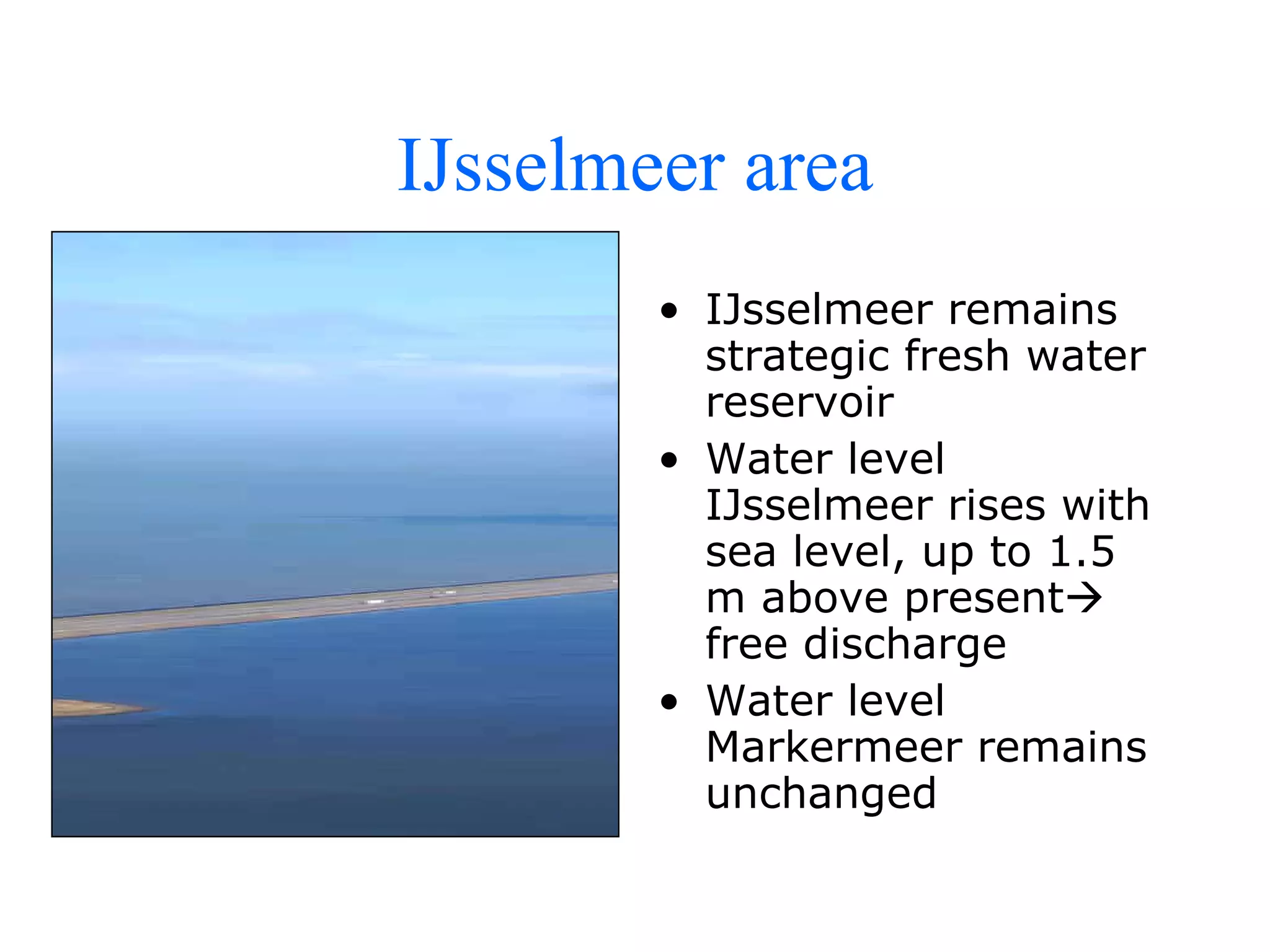
Presented by representative of the Dutch Government, focussing on the past, present and future ways of managing water within the Netherlands, dealing strongly with flood prevention and safety measures
Digitizing in GIS is the process of converting geographic data either from a hardcopy or a scanned image into vector data by tracing the features. During the digitzing process, features from the traced map or image are captured as coordinates in either point, line, or polygon format
Geodatabase: The ArcGIS Mechanism for Data ManagementEsri South Africa
This presentation is about understanding the content that goes into a geodatabase, advantages of using geodatabases, data management and maintaining data integrity.
It is a presentation made on the actual work done on site for the selection of construction site for the dam,it can be used as well for other site suitability.
Also known as geospatial data or geographic information it is the data or information that identifies the geographic location of features and boundaries on Earth, such as natural or constructed features, oceans, and more. Spatial data is usually stored as coordinates and topology, and is data that can be mapped.
Application of GIS in Modelling Landuse Changes Of Gurupavanapuri, Kerala, IndiaSharik Shamsudhien
The Project Presentation focuses on the land use and land cover change pattern of Gurupavanapuri and environs, an area which is in the State of Kerala , India.
The work was mainly aimed to identify the rapid urbanization that took over in the Gurupavanapuri and its environs during the year 2002 and 2017 and on analysis there was a clear reduction of natural vegetated area due to the human influenced constructions.
The Project was completed using The ArcGis which is a GIS application. Remote Sensing data collection, such as SRTM DEM, ETOPO1 data (Bathymetry and Oceanic bedrock surface) has been achieved.
GIS Application in Water Resource Management by Engr. Ehtisham HabibEhtisham Habib
GIS (Geographic Information System): computer information system that can input, store, manipulate, analyze, and display geographically referenced (spatial) data to support decision making processes.
Here we have discussed some general GIS application in water resource management.
Fokkens B. ECRR, Flood prevention and river restoration, Room for the river RESTORE
1. Changes in the natural environment of a river
2. Loss of floodplain surface in upper Rhine
3. “Ecological obstacles”
4. River restoration ready for the future?
5. Restoring habitat connectivity
Dale Morris, Senior Economist, Royal Dutch Embassy, The Dutch National Plan: The Delta Commission; National Institute for Coastal & Harbor Infrastructure, John F. Kennedy Center, Boston, Nov. 12, 2013: "The Triple Threat of Rising Sea Levels, Extreme Storms and Aging Infrastructure: Coastal Community Responses and The Federal Role." See http://www.nichiusa.org or http://www.nichi.us
Following on her 'Room for the River' op-ed in the Washington Post, Ambassador Jones-Bos and the Embassy's Water Management specialist Dale Morris delivered a presentation to river and floodplain managers during the conference of the Natural Floodplain Functions Alliance.
The development of this new edition of the Baltic Sea presentation package was inspired by the Gulf of Finland Year 2014, in order to contribute to the intensive work on augmenting the scientific knowledge base and awareness of the Baltic Sea.
The content of the presentation package demonstrates, on one hand, the physical, chemical and biological characteristics of the Baltic Sea and, on the other hand, the challenges presented by the Baltic. The last parts of the presentation package demonstrate various ways in which society is already acting, and can in the future continue to act to influence the future of the Baltic Sea to ensure
the sustainable use of its environment. At the end, the question is posed to all of us: what can I personally do for the Baltic Sea?
Version of the presentation with the internal hyperlinks can be downloaded at http://www.gof2014.fi/en/environmental-education/environmental-educationthe-baltic-sea-environment-and-ecology/
This presentation package can be downloaded and used free of charge. The editorial group owns the copyright to the slide series. Petri Kuokka owns the copyright to the figures and layout. The package can either be downloaded or used directly from the Internet.
Francesca Gottschalk - How can education support child empowerment.pptxEduSkills OECD
Francesca Gottschalk from the OECD’s Centre for Educational Research and Innovation presents at the Ask an Expert Webinar: How can education support child empowerment?
Acetabularia Information For Class 9 .docxvaibhavrinwa19
Acetabularia acetabulum is a single-celled green alga that in its vegetative state is morphologically differentiated into a basal rhizoid and an axially elongated stalk, which bears whorls of branching hairs. The single diploid nucleus resides in the rhizoid.
Instructions for Submissions thorugh G- Classroom.pptxJheel Barad
This presentation provides a briefing on how to upload submissions and documents in Google Classroom. It was prepared as part of an orientation for new Sainik School in-service teacher trainees. As a training officer, my goal is to ensure that you are comfortable and proficient with this essential tool for managing assignments and fostering student engagement.
Honest Reviews of Tim Han LMA Course Program.pptxtimhan337
Personal development courses are widely available today, with each one promising life-changing outcomes. Tim Han’s Life Mastery Achievers (LMA) Course has drawn a lot of interest. In addition to offering my frank assessment of Success Insider’s LMA Course, this piece examines the course’s effects via a variety of Tim Han LMA course reviews and Success Insider comments.
Palestine last event orientationfvgnh .pptxRaedMohamed3
An EFL lesson about the current events in Palestine. It is intended to be for intermediate students who wish to increase their listening skills through a short lesson in power point.
Synthetic Fiber Construction in lab .pptxPavel ( NSTU)
Synthetic fiber production is a fascinating and complex field that blends chemistry, engineering, and environmental science. By understanding these aspects, students can gain a comprehensive view of synthetic fiber production, its impact on society and the environment, and the potential for future innovations. Synthetic fibers play a crucial role in modern society, impacting various aspects of daily life, industry, and the environment. ynthetic fibers are integral to modern life, offering a range of benefits from cost-effectiveness and versatility to innovative applications and performance characteristics. While they pose environmental challenges, ongoing research and development aim to create more sustainable and eco-friendly alternatives. Understanding the importance of synthetic fibers helps in appreciating their role in the economy, industry, and daily life, while also emphasizing the need for sustainable practices and innovation.
Introduction to AI for Nonprofits with Tapp NetworkTechSoup
Dive into the world of AI! Experts Jon Hill and Tareq Monaur will guide you through AI's role in enhancing nonprofit websites and basic marketing strategies, making it easy to understand and apply.
A Strategic Approach: GenAI in EducationPeter Windle
Artificial Intelligence (AI) technologies such as Generative AI, Image Generators and Large Language Models have had a dramatic impact on teaching, learning and assessment over the past 18 months. The most immediate threat AI posed was to Academic Integrity with Higher Education Institutes (HEIs) focusing their efforts on combating the use of GenAI in assessment. Guidelines were developed for staff and students, policies put in place too. Innovative educators have forged paths in the use of Generative AI for teaching, learning and assessments leading to pockets of transformation springing up across HEIs, often with little or no top-down guidance, support or direction.
This Gasta posits a strategic approach to integrating AI into HEIs to prepare staff, students and the curriculum for an evolving world and workplace. We will highlight the advantages of working with these technologies beyond the realm of teaching, learning and assessment by considering prompt engineering skills, industry impact, curriculum changes, and the need for staff upskilling. In contrast, not engaging strategically with Generative AI poses risks, including falling behind peers, missed opportunities and failing to ensure our graduates remain employable. The rapid evolution of AI technologies necessitates a proactive and strategic approach if we are to remain relevant.
Biological screening of herbal drugs: Introduction and Need for
Phyto-Pharmacological Screening, New Strategies for evaluating
Natural Products, In vitro evaluation techniques for Antioxidants, Antimicrobial and Anticancer drugs. In vivo evaluation techniques
for Anti-inflammatory, Antiulcer, Anticancer, Wound healing, Antidiabetic, Hepatoprotective, Cardio protective, Diuretics and
Antifertility, Toxicity studies as per OECD guidelines
Welcome to TechSoup New Member Orientation and Q&A (May 2024).pdfTechSoup
In this webinar you will learn how your organization can access TechSoup's wide variety of product discount and donation programs. From hardware to software, we'll give you a tour of the tools available to help your nonprofit with productivity, collaboration, financial management, donor tracking, security, and more.
Macroeconomics- Movie Location
This will be used as part of your Personal Professional Portfolio once graded.
Objective:
Prepare a presentation or a paper using research, basic comparative analysis, data organization and application of economic information. You will make an informed assessment of an economic climate outside of the United States to accomplish an entertainment industry objective.
A typical cross section of our rivers consists of a navigation channel with groins, mostly embanked by low (summer) dikes, a flood plain and the main dikes.