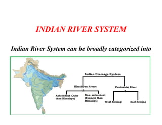
Class 9th
Chapter No 3
Drainge System of
India
Any Natural Stream Of water That flows in a channel
with defined banks, The river join by other streams
are generally called Tributaries. The River along with
all its tributaries from the River system..
How River affects
.
When a river along with its tributaries drains
an area, it affects the area in many ways
Vegetation, Agriculture Patterns Human
Settlements all can be affected by this.
Area Drained by river and its tributaries are known as
Drainage Basin.
Like Missipii in USA, the Nile in Africa, The Congo
Drainage basin in Africa. The Amazon Basin.
In India Ganga River forms the largest drainage
Basin. These drainage basin go through various
changes with the course of time due to some geological
events. Like the formations of Water Divide,.
Water divide an elevated area which separates two
drainage basins.
Rivers
The Life giving gift of nature to humans. Rivers
usually flow from a place that is relatively higher
altitude to a place having a lower altitude . The
Journery of river having 3 stage
The Youthful Stage
The Youthful Stage is dominated by vertical
erosion. Mostly erosion landforms are
crated in this stage. E.g Gorges, valley and
Waterfall are formed in this stage. The River
carries huge amount of sand and silt in this
stage.
Mature Stage or Middle Course.
IN This stage the stage of river flow is reduced in this
stage the in the youthful stage. Lateral erosion
dominates the mature stage and can be observed on
the sides of the river. Some erosional and
depositional landforms can be observed in this stage
e.g Oxbow lakes, meanders, flood plains are common
land forms in this stage.
Older Stage or Lower Course.
In this Stage the river flows very slowly and calmly.
Mainly deposition is observed in this stage. The Huge
amount of sand and silt carried by the rivers from the
upper course is deposited in this stage. Most of the
landform we found in this stage are depositional
landforms and deltas.
INDIAN RIVER SYSTEM
Indian River System can be broadly categorized into
INDIAN RIVER SYSTEM
Himalayan Rivers Peninsular Rivers
Himalayan Rivers Originates
from the Himalayas
Peninsular Rivers Originates
from the Deccan Plateau
Most of the Himalayan Rivers
are very long
Most of the Peninsular Rivers
are shorter
Himalayan Rivers are
Perennial
Peninsular rivers dry up during
summer months
Himalayan rivers have a much
larger basins
Peninsular rivers have a smaller
basins
Indus River System
It is one of the longest rivers in the world and one
of the important River system in the world. This
river was home to one of the oldest civilization in
the world The Harappan civilization. That has a
history of more then 4500 years.
The Indus River system begin journey near Mansarovar lake
in Tibet in China the people identify the river as Sange
khumbad or lion mouth.
From Tibet it flows towards west the enter India
through Ladakh, there are some exquisite site of
the Gorge made by the Indus river along its
course in this region
The Zanskar , The Nubra The Hunza and the
Shayok are some of its tributaries that join the
Indus river from here the Indus river flows
through the region of Baltistan and Gilgit a
region in Paksitan.
Some other tributaries that Joins Indus are the
Satluj ,The Beas, The Ravi, The Chenab, and
the Jehlum all of them join together to enter the
river near in the city Mithonkot situated in
Pakistan the river then flows south and drains
into the Arabian sea.
This journey spanning at about 2900 Kms. One third of the river located in
India and rest in Pakistan, so this is the journey of the river Indus that starts
from Tibet and end in Arabian sea.
The river has been also a source of conflict between India and Pakistan as
there were shared by both the countries there has been some disagreement
between the two countries about how to get how much water so to solve this
issue the Indus river water treaty as sign Ed in 1960 known as Indus water
treaty 1960 that really gives the water of the Western river that is in the Jhelum
and the janab to Pakistan and those of the east river the Ravi beas and Sutlej to
India consequently India can use 20% of the total water of Indus River system
and use this river in the irrigation work in Punjab Haryana and Rajasthan
Drainage 9th class

Drainage 9th class

  • 1.
    Class 9th Chapter No3 Drainge System of India
  • 2.
    Any Natural StreamOf water That flows in a channel with defined banks, The river join by other streams are generally called Tributaries. The River along with all its tributaries from the River system..
  • 3.
    How River affects . Whena river along with its tributaries drains an area, it affects the area in many ways Vegetation, Agriculture Patterns Human Settlements all can be affected by this.
  • 4.
    Area Drained byriver and its tributaries are known as Drainage Basin. Like Missipii in USA, the Nile in Africa, The Congo Drainage basin in Africa. The Amazon Basin. In India Ganga River forms the largest drainage Basin. These drainage basin go through various changes with the course of time due to some geological events. Like the formations of Water Divide,. Water divide an elevated area which separates two drainage basins.
  • 5.
    Rivers The Life givinggift of nature to humans. Rivers usually flow from a place that is relatively higher altitude to a place having a lower altitude . The Journery of river having 3 stage
  • 6.
    The Youthful Stage TheYouthful Stage is dominated by vertical erosion. Mostly erosion landforms are crated in this stage. E.g Gorges, valley and Waterfall are formed in this stage. The River carries huge amount of sand and silt in this stage.
  • 7.
    Mature Stage orMiddle Course. IN This stage the stage of river flow is reduced in this stage the in the youthful stage. Lateral erosion dominates the mature stage and can be observed on the sides of the river. Some erosional and depositional landforms can be observed in this stage e.g Oxbow lakes, meanders, flood plains are common land forms in this stage.
  • 8.
    Older Stage orLower Course. In this Stage the river flows very slowly and calmly. Mainly deposition is observed in this stage. The Huge amount of sand and silt carried by the rivers from the upper course is deposited in this stage. Most of the landform we found in this stage are depositional landforms and deltas.
  • 9.
    Older Stage orLower Course. In this Stage the river flows very slowly and calmly. Mainly deposition is observed in this stage. The Huge amount of sand and silt carried by the rivers from the upper course is deposited in this stage. Most of the landform we found in this stage are depositional landforms and deltas.
  • 10.
    INDIAN RIVER SYSTEM IndianRiver System can be broadly categorized into
  • 11.
    INDIAN RIVER SYSTEM HimalayanRivers Peninsular Rivers Himalayan Rivers Originates from the Himalayas Peninsular Rivers Originates from the Deccan Plateau Most of the Himalayan Rivers are very long Most of the Peninsular Rivers are shorter Himalayan Rivers are Perennial Peninsular rivers dry up during summer months Himalayan rivers have a much larger basins Peninsular rivers have a smaller basins
  • 12.
    Indus River System Itis one of the longest rivers in the world and one of the important River system in the world. This river was home to one of the oldest civilization in the world The Harappan civilization. That has a history of more then 4500 years.
  • 13.
    The Indus Riversystem begin journey near Mansarovar lake in Tibet in China the people identify the river as Sange khumbad or lion mouth.
  • 14.
    From Tibet itflows towards west the enter India through Ladakh, there are some exquisite site of the Gorge made by the Indus river along its course in this region
  • 15.
    The Zanskar ,The Nubra The Hunza and the Shayok are some of its tributaries that join the Indus river from here the Indus river flows through the region of Baltistan and Gilgit a region in Paksitan.
  • 16.
    Some other tributariesthat Joins Indus are the Satluj ,The Beas, The Ravi, The Chenab, and the Jehlum all of them join together to enter the river near in the city Mithonkot situated in Pakistan the river then flows south and drains into the Arabian sea.
  • 17.
    This journey spanningat about 2900 Kms. One third of the river located in India and rest in Pakistan, so this is the journey of the river Indus that starts from Tibet and end in Arabian sea.
  • 18.
    The river hasbeen also a source of conflict between India and Pakistan as there were shared by both the countries there has been some disagreement between the two countries about how to get how much water so to solve this issue the Indus river water treaty as sign Ed in 1960 known as Indus water treaty 1960 that really gives the water of the Western river that is in the Jhelum and the janab to Pakistan and those of the east river the Ravi beas and Sutlej to India consequently India can use 20% of the total water of Indus River system and use this river in the irrigation work in Punjab Haryana and Rajasthan