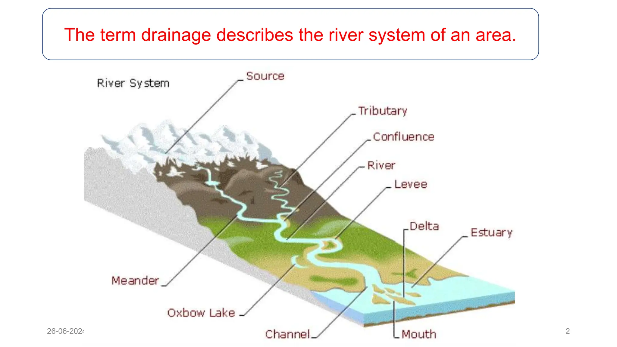
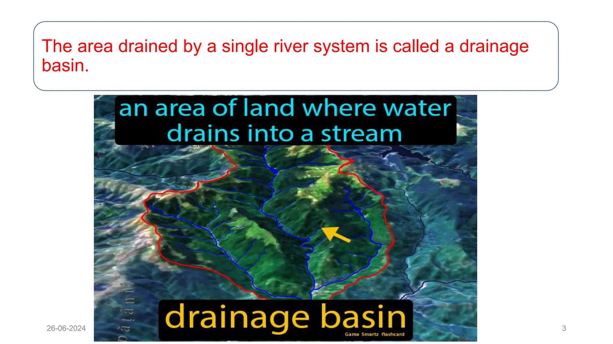
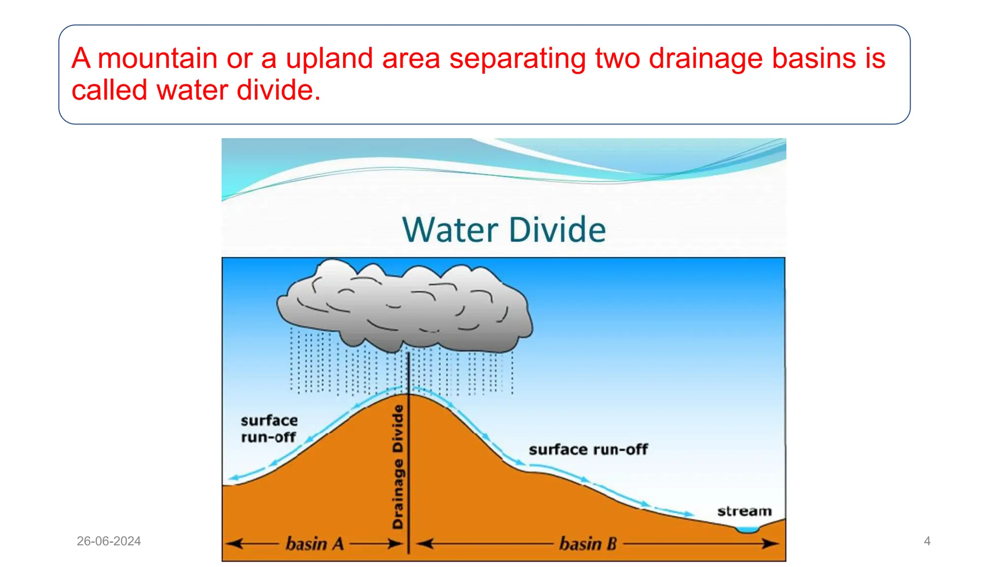
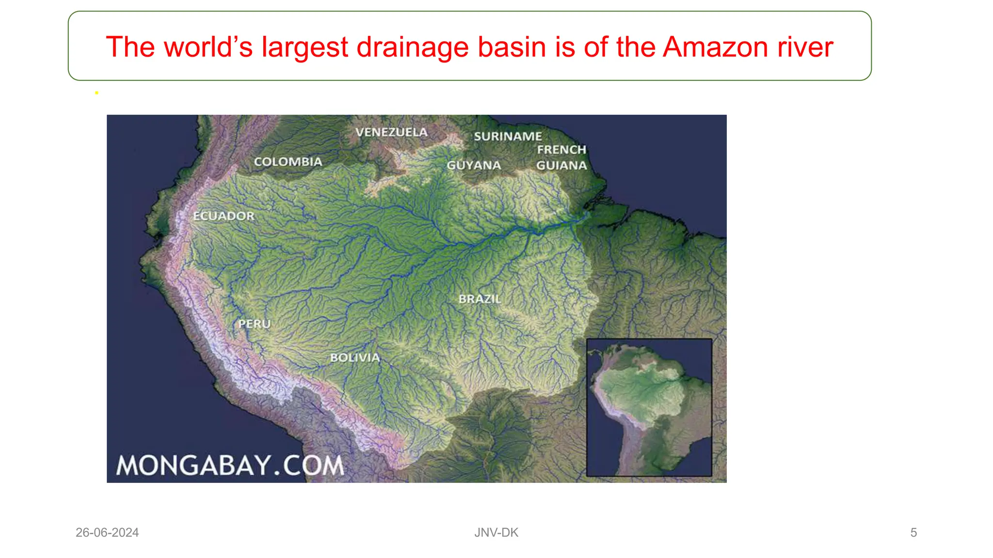
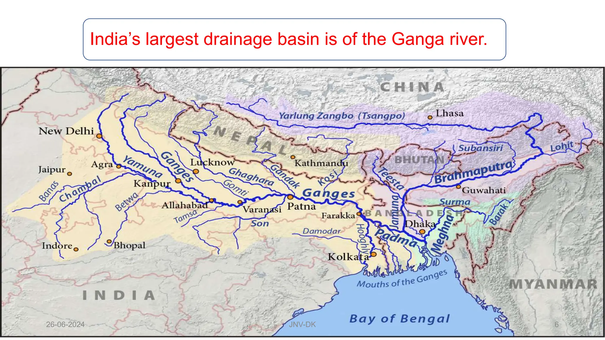
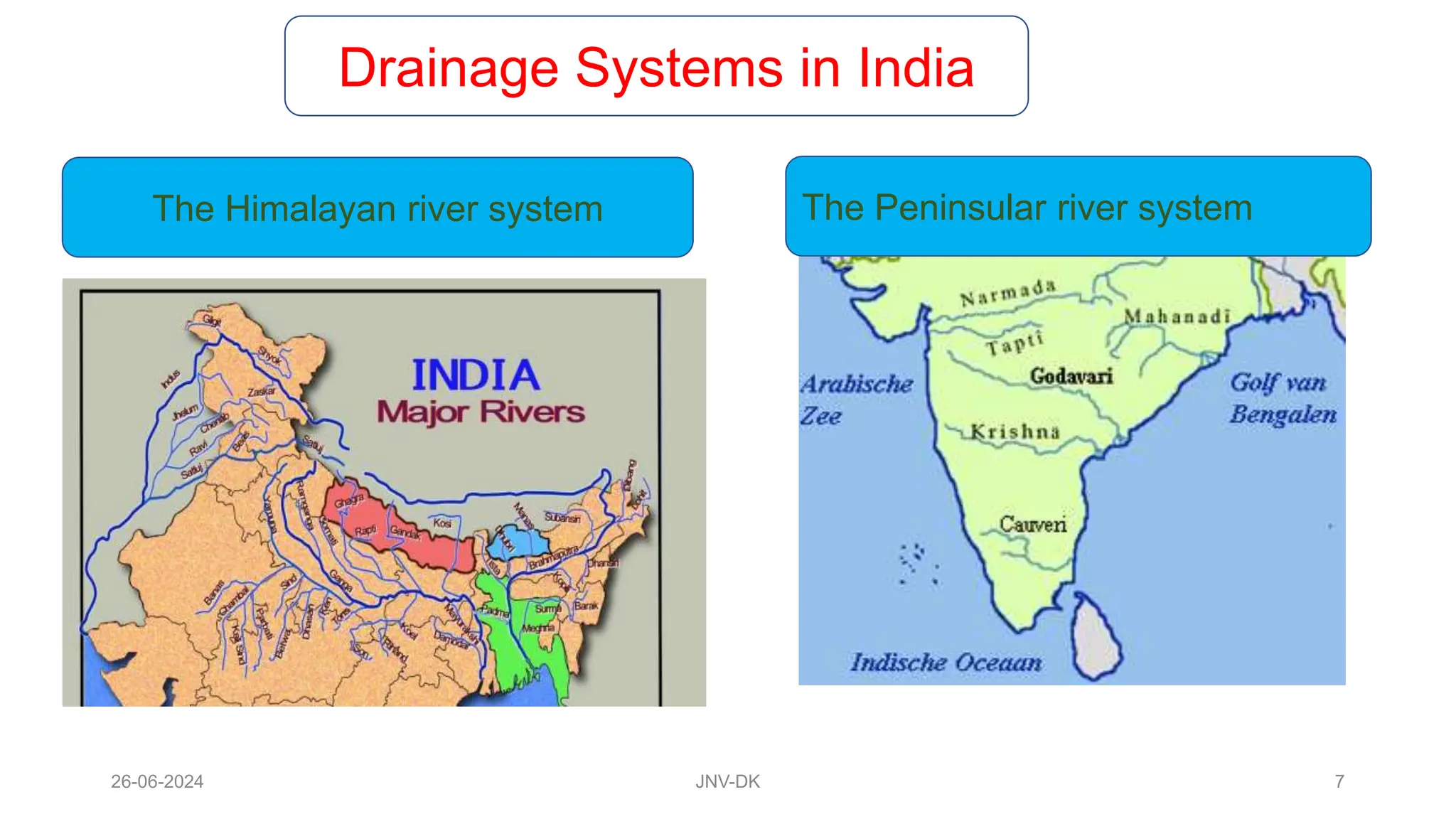
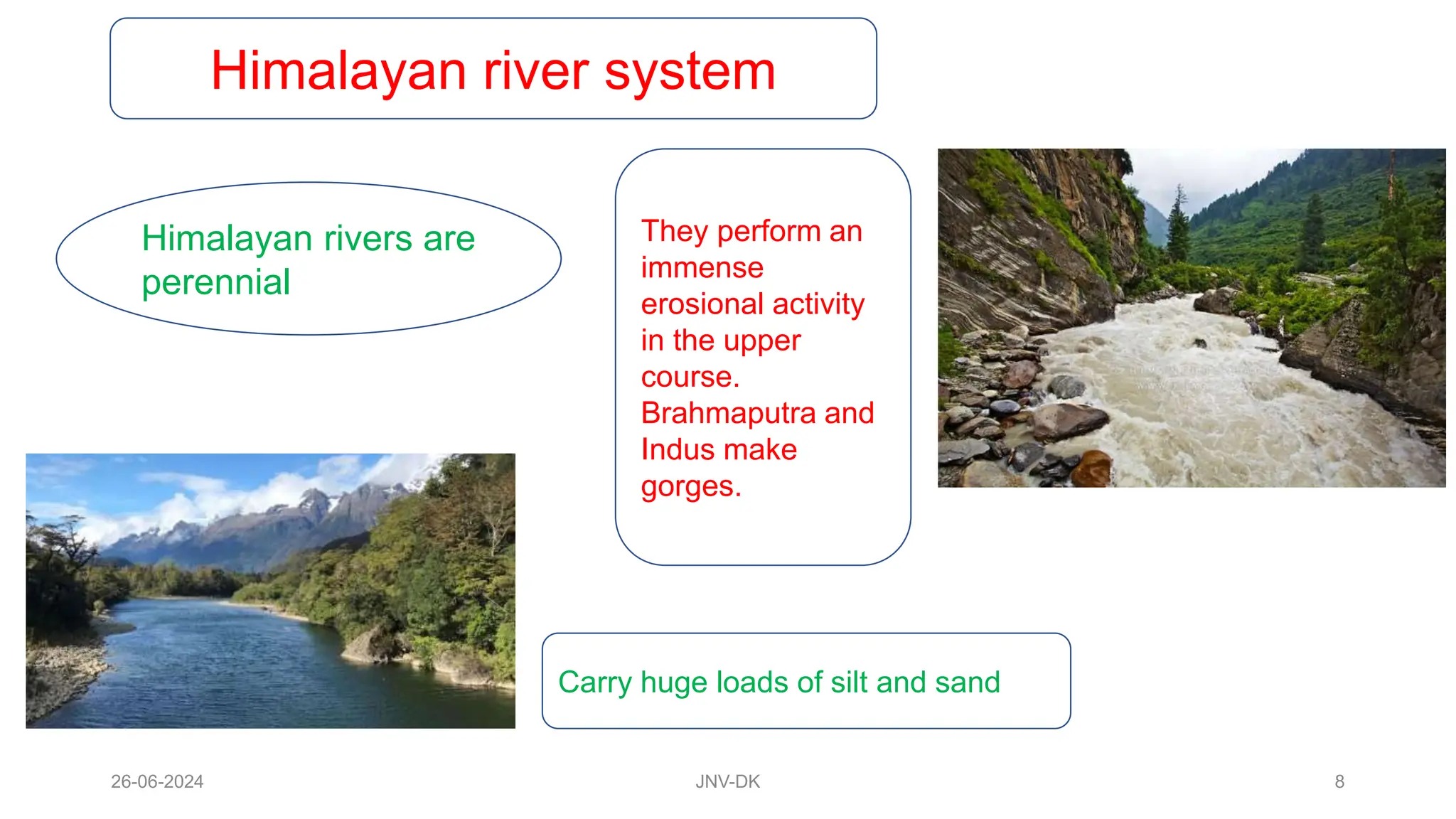
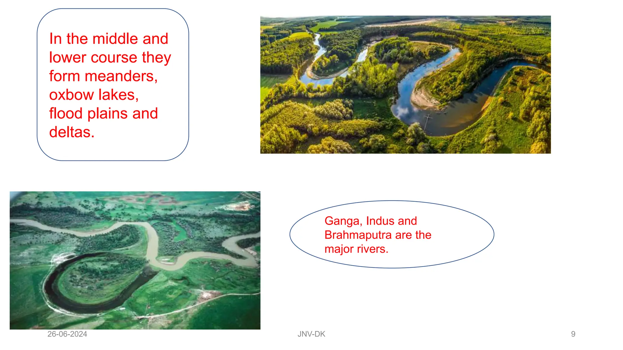
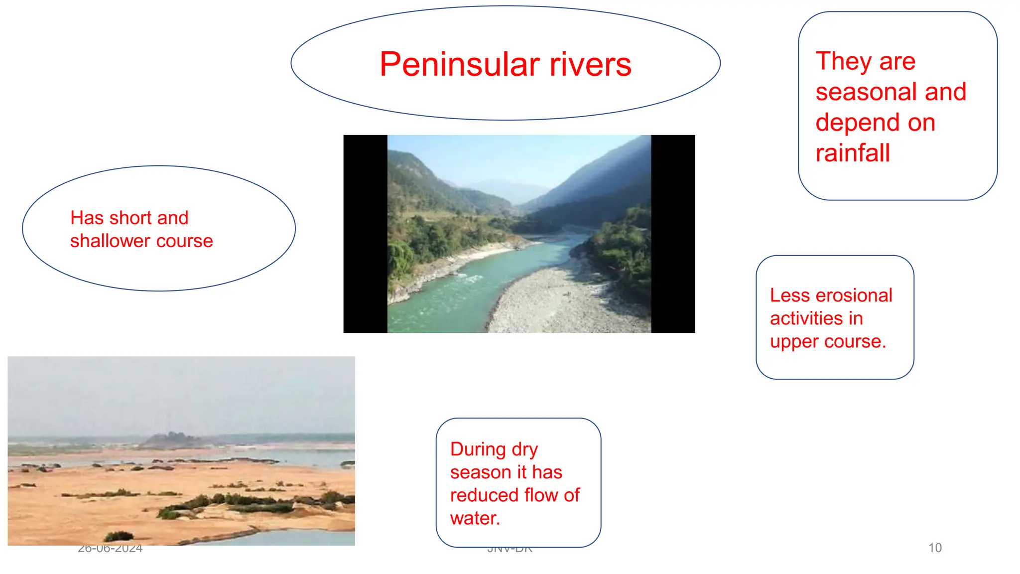
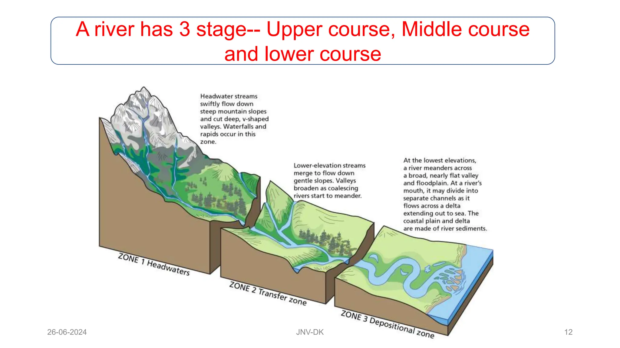
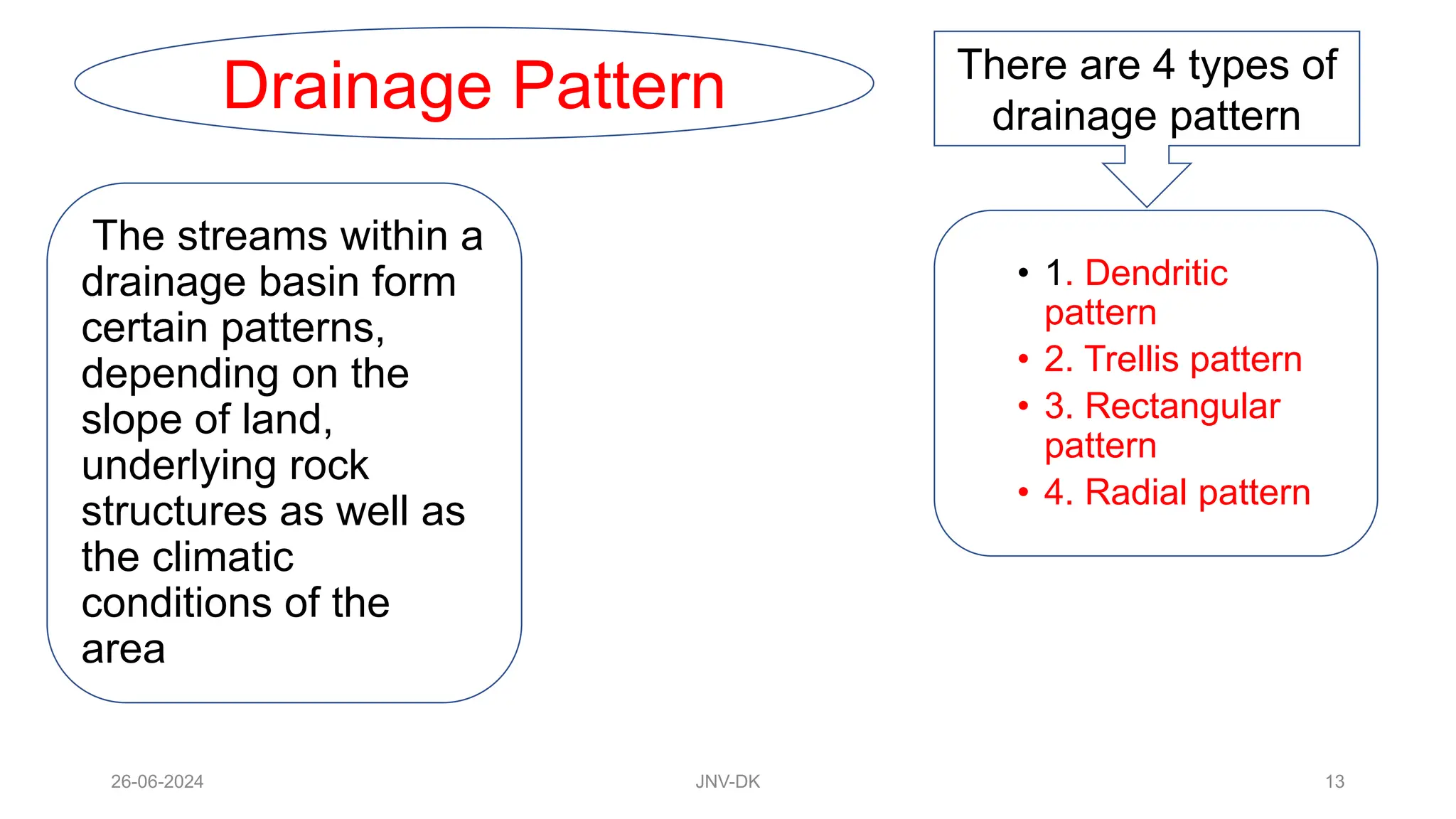
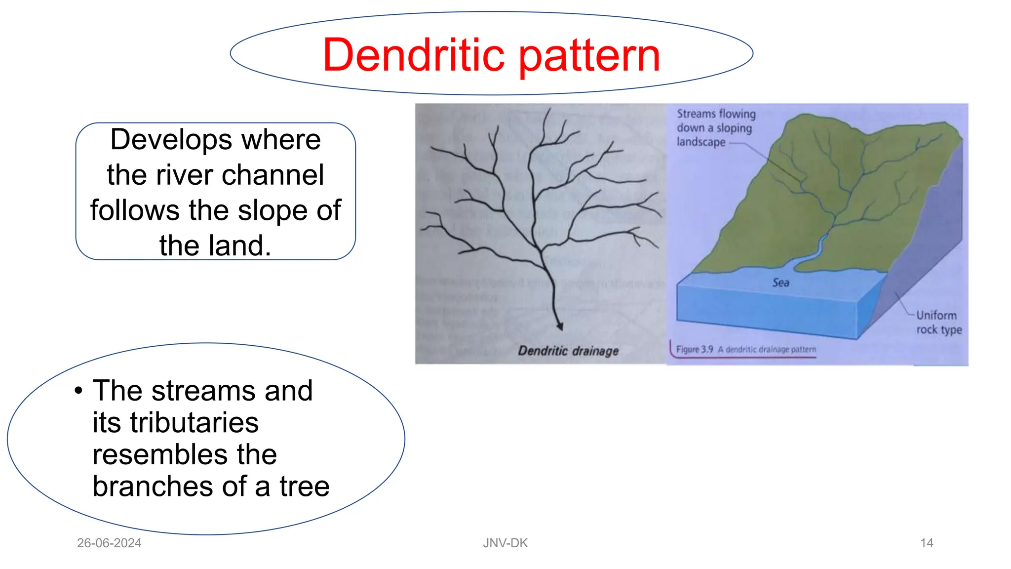
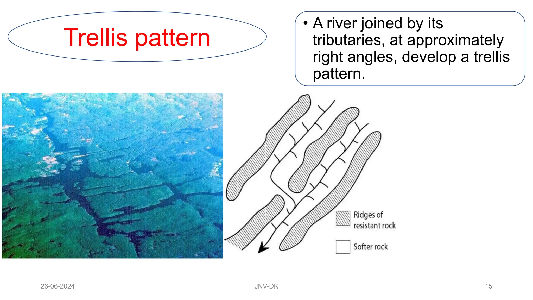
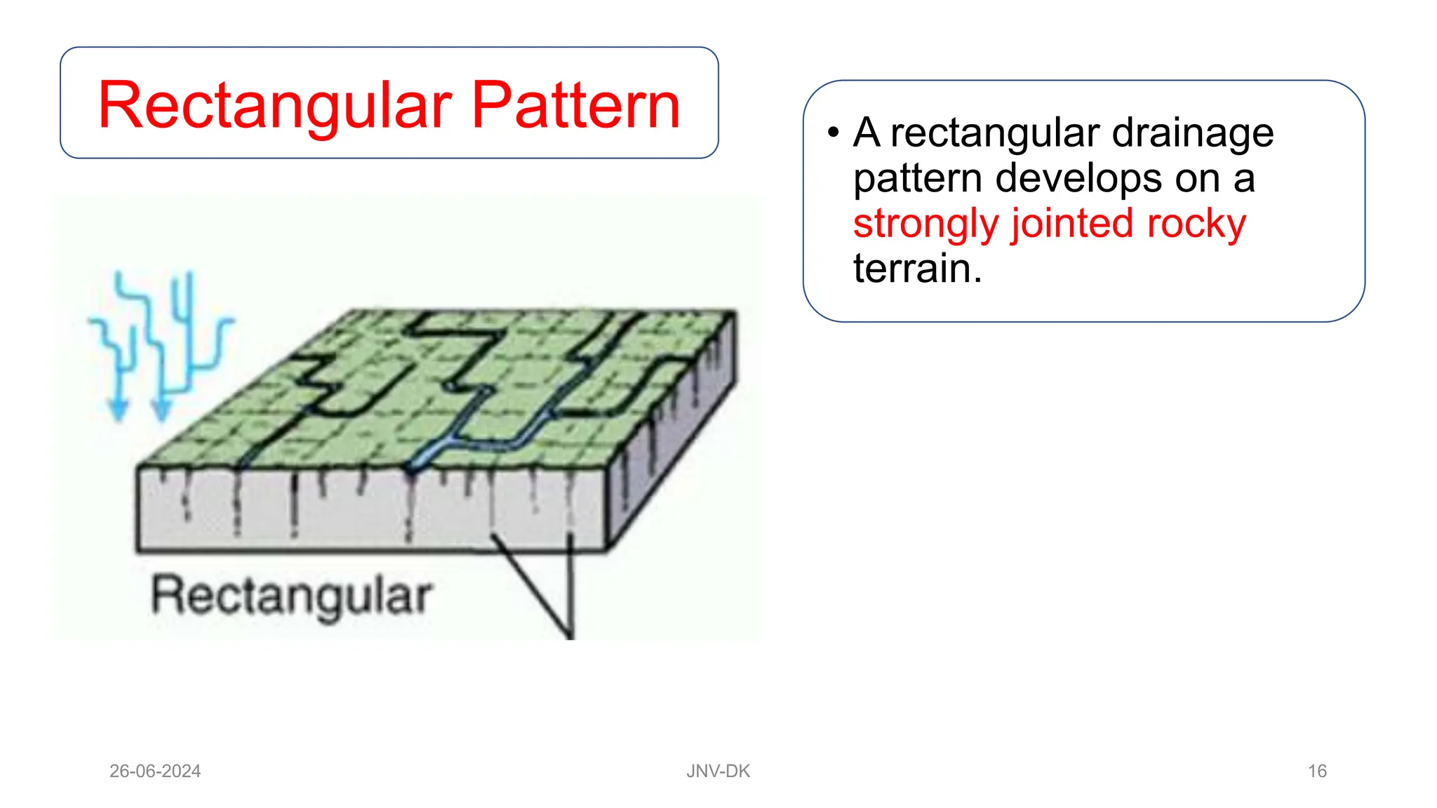
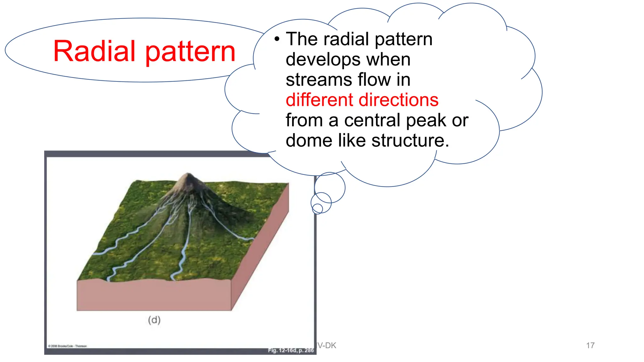
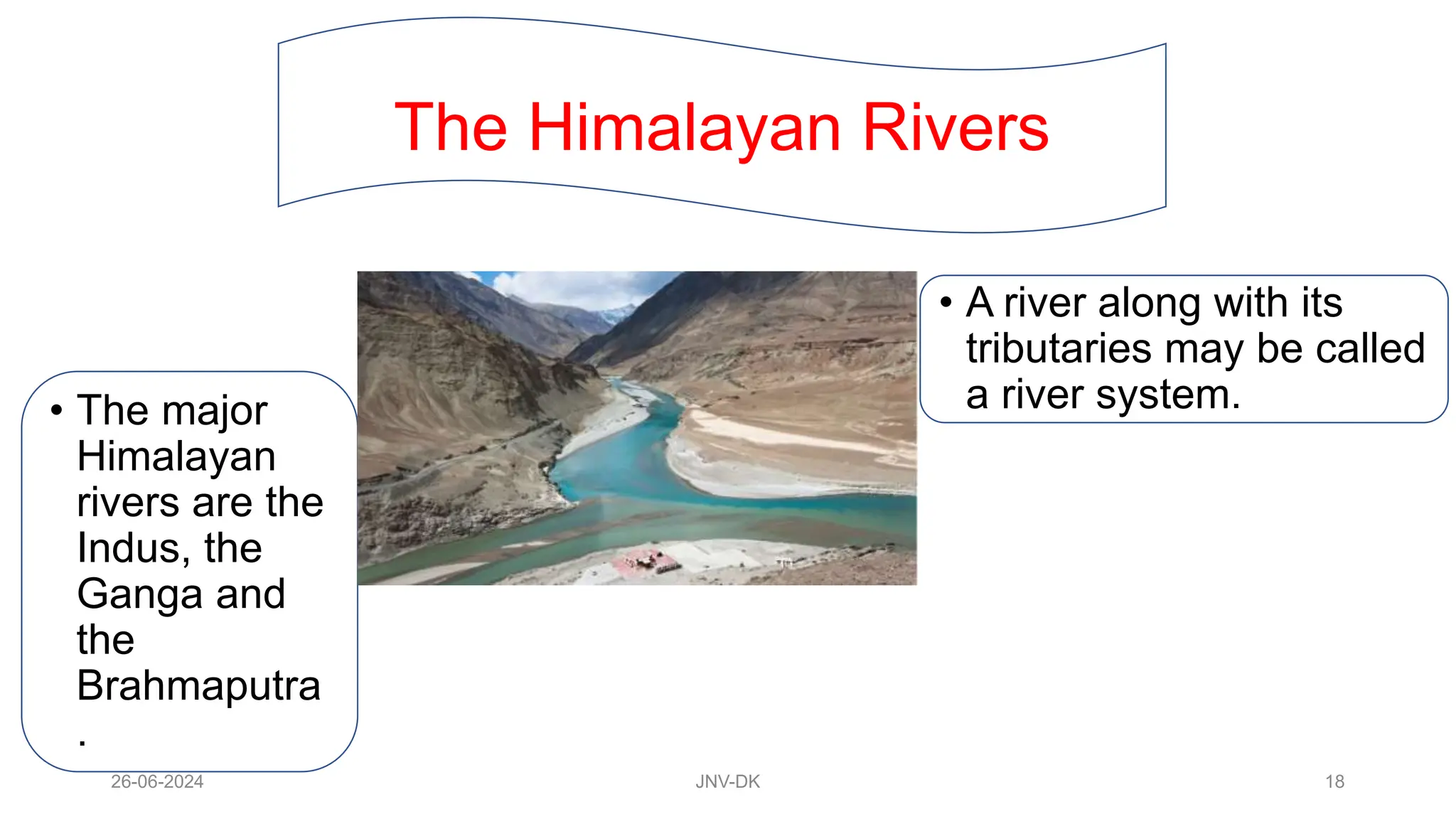
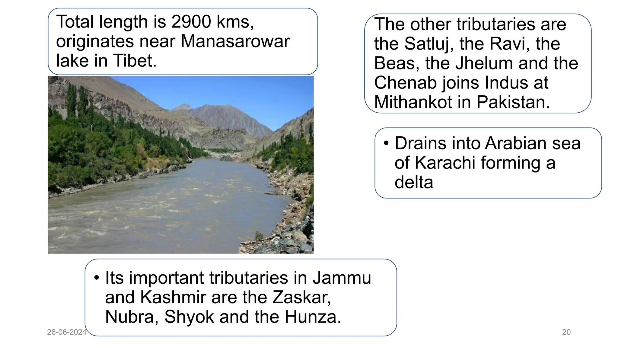
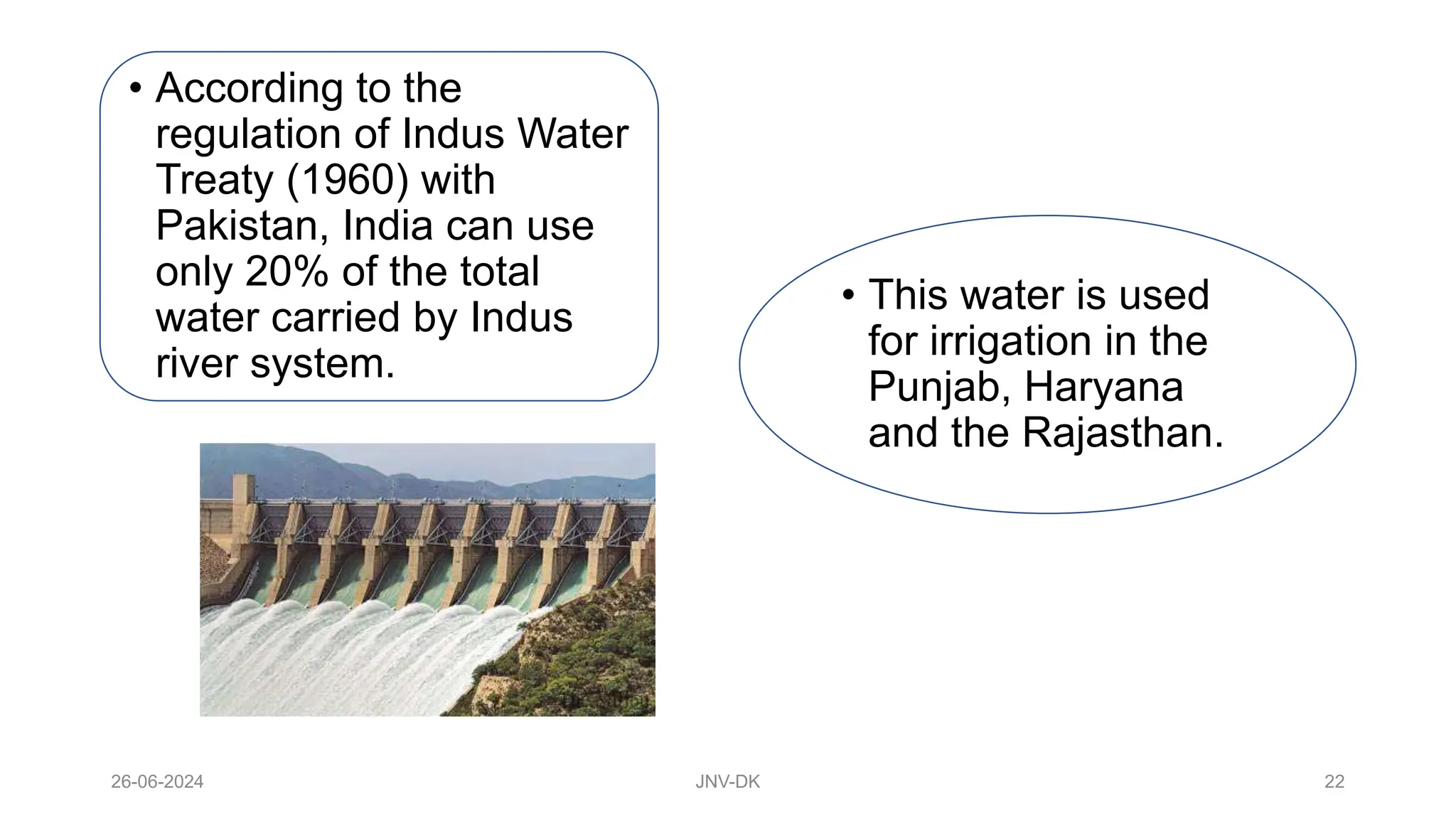
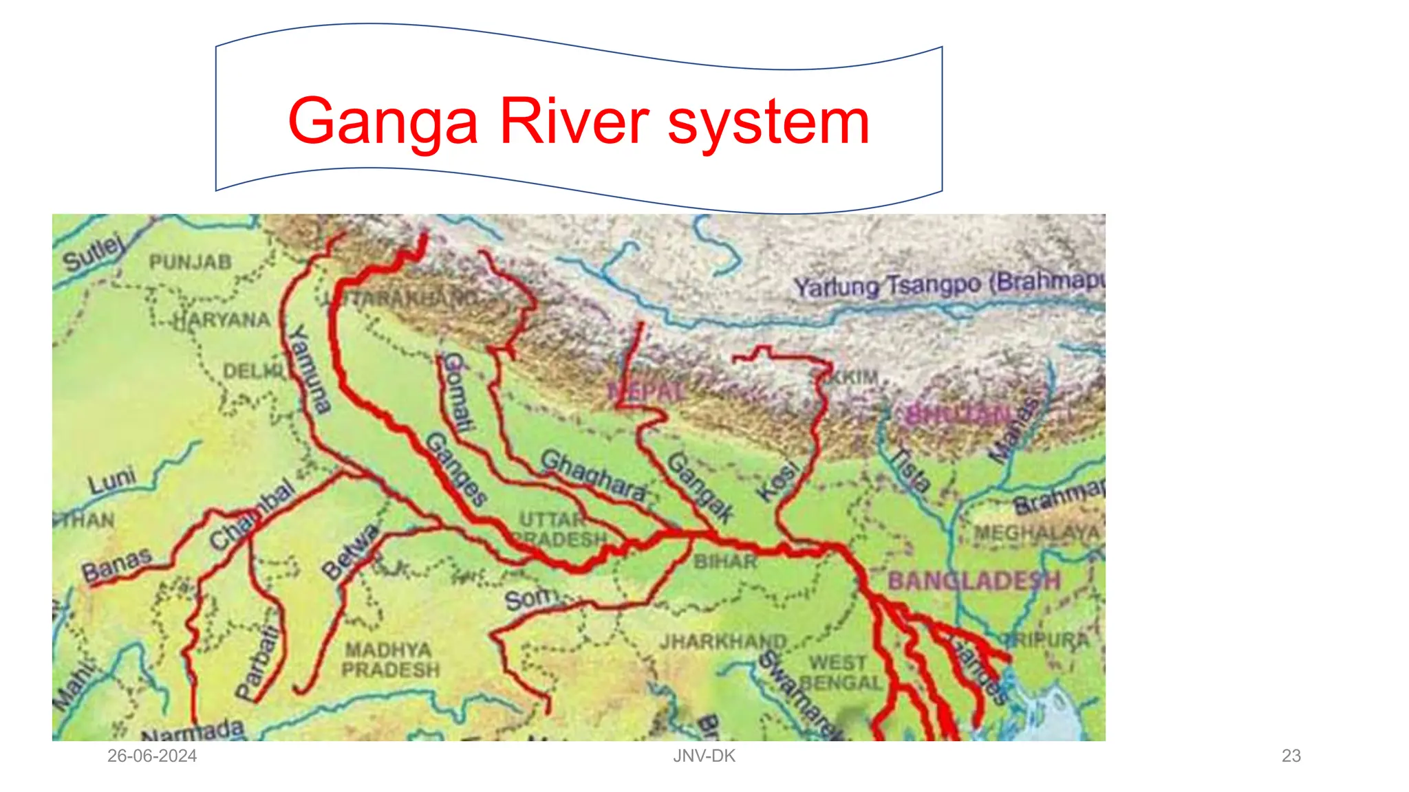
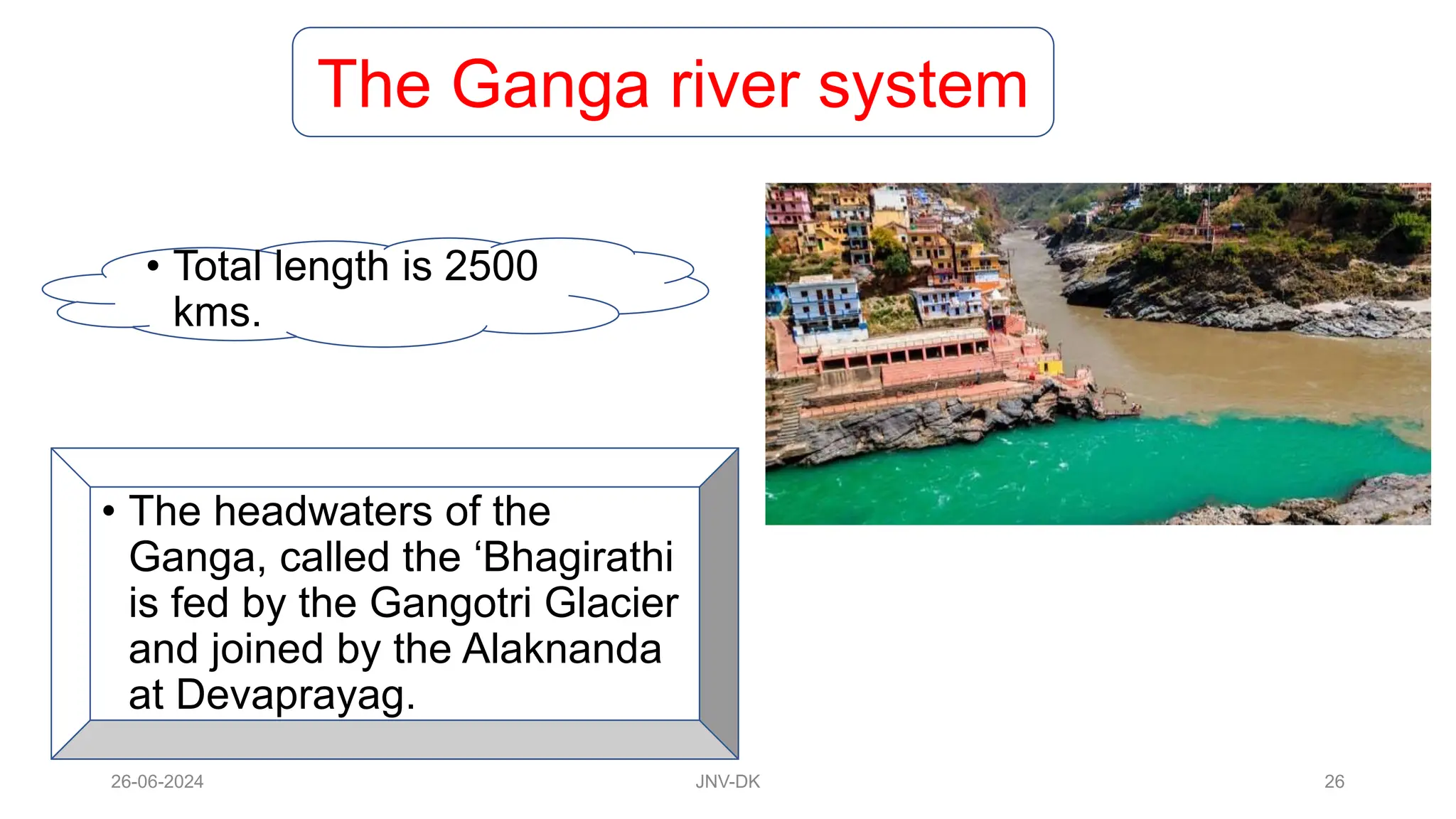
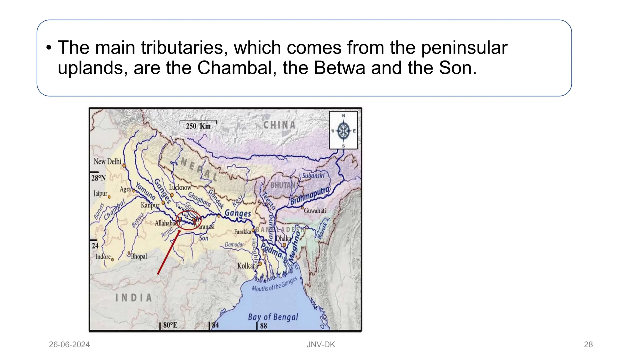
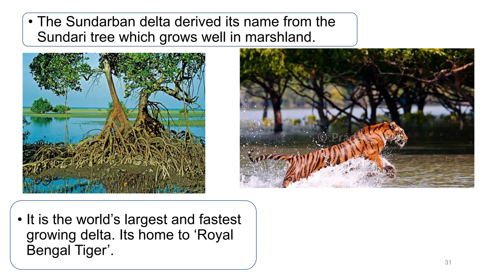
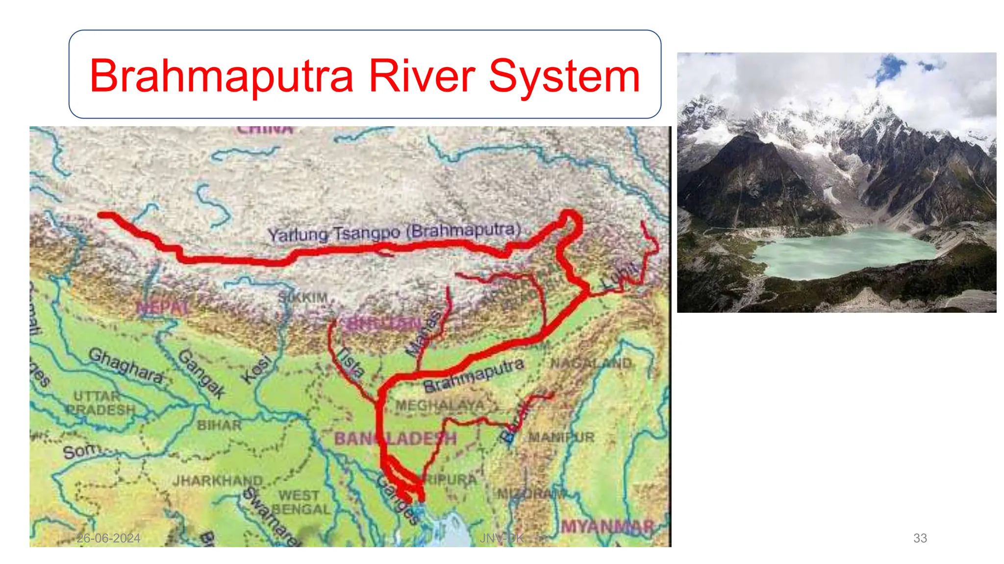
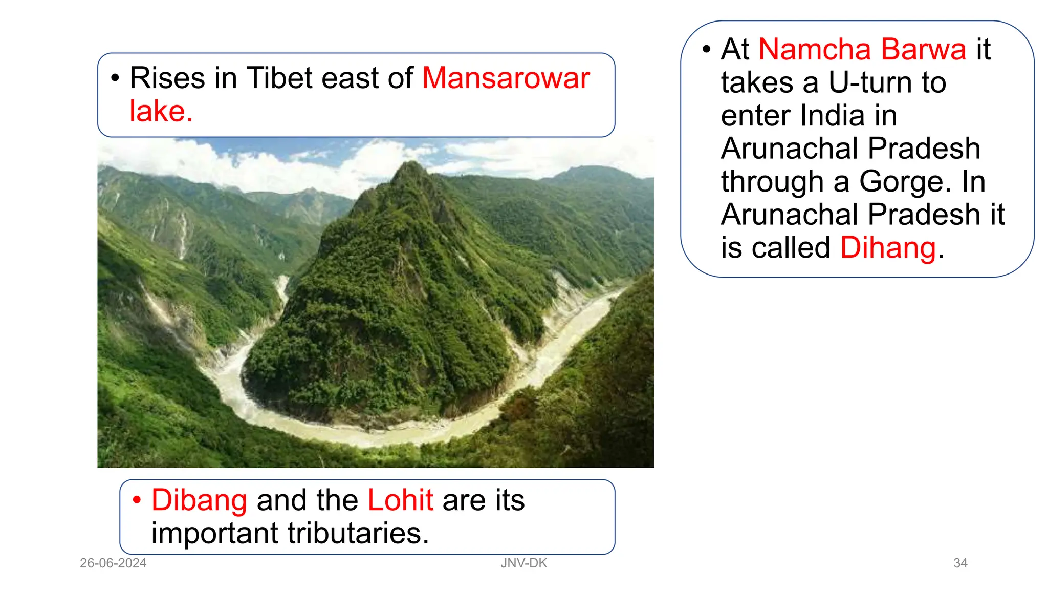
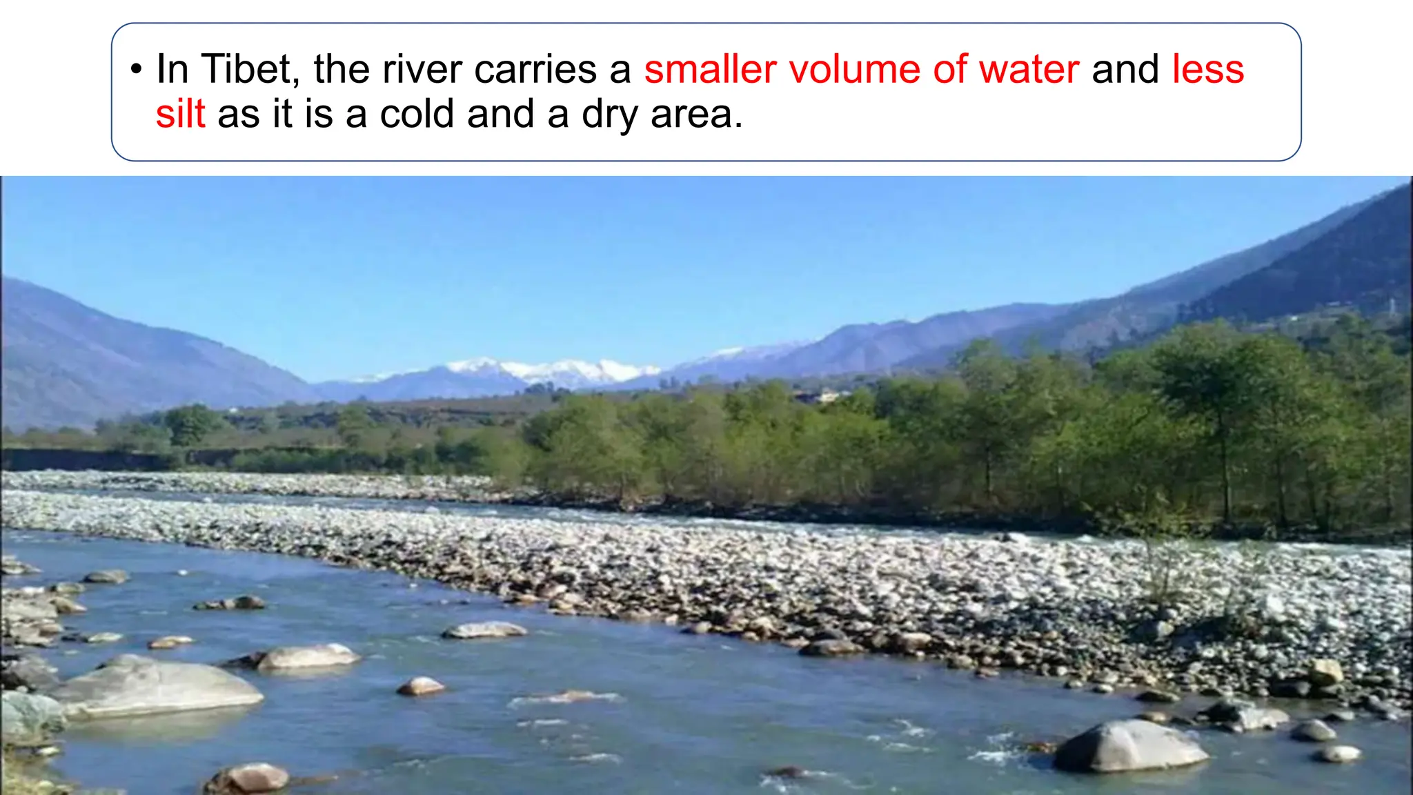
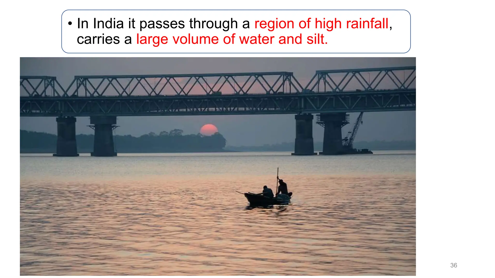
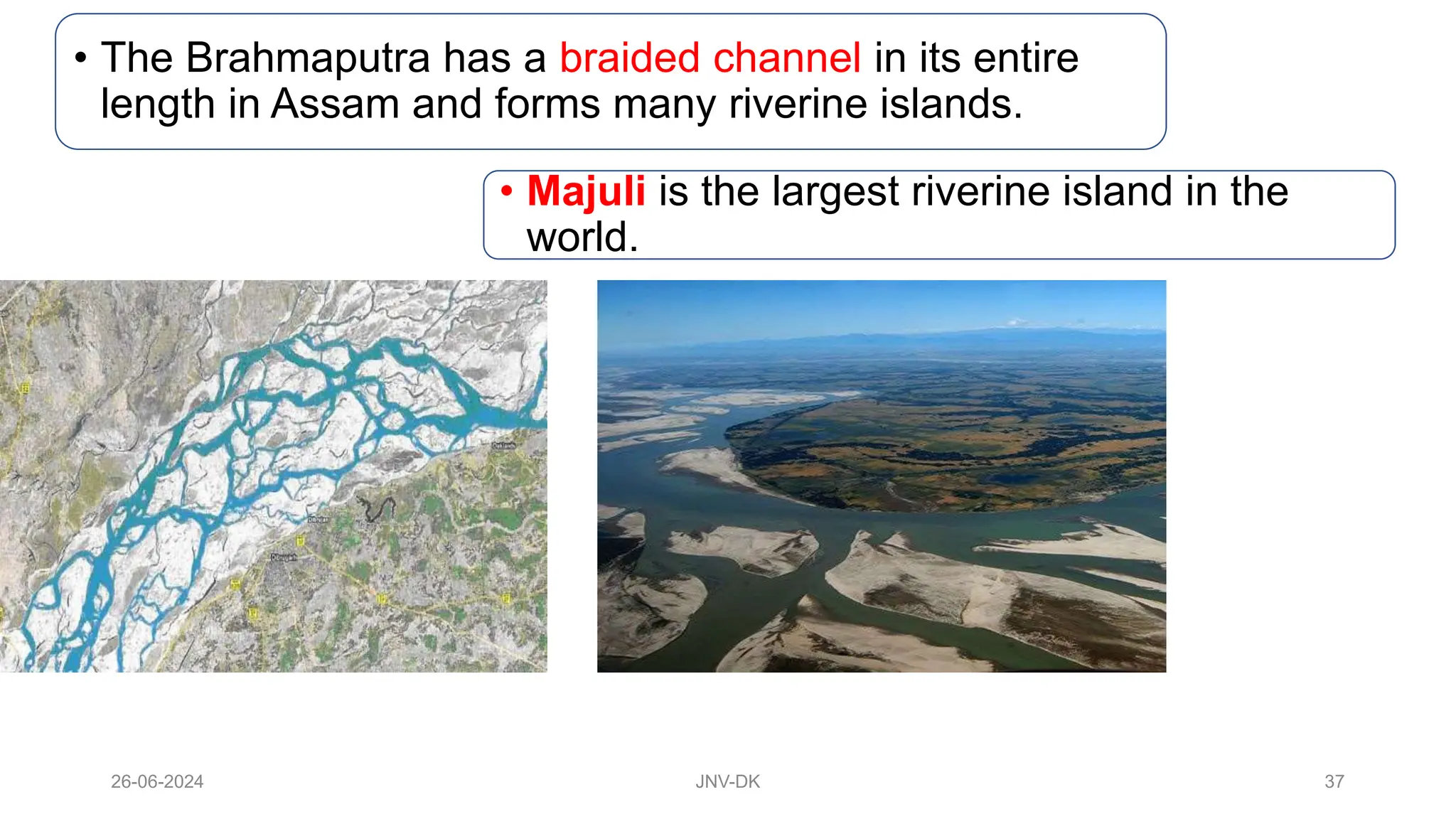
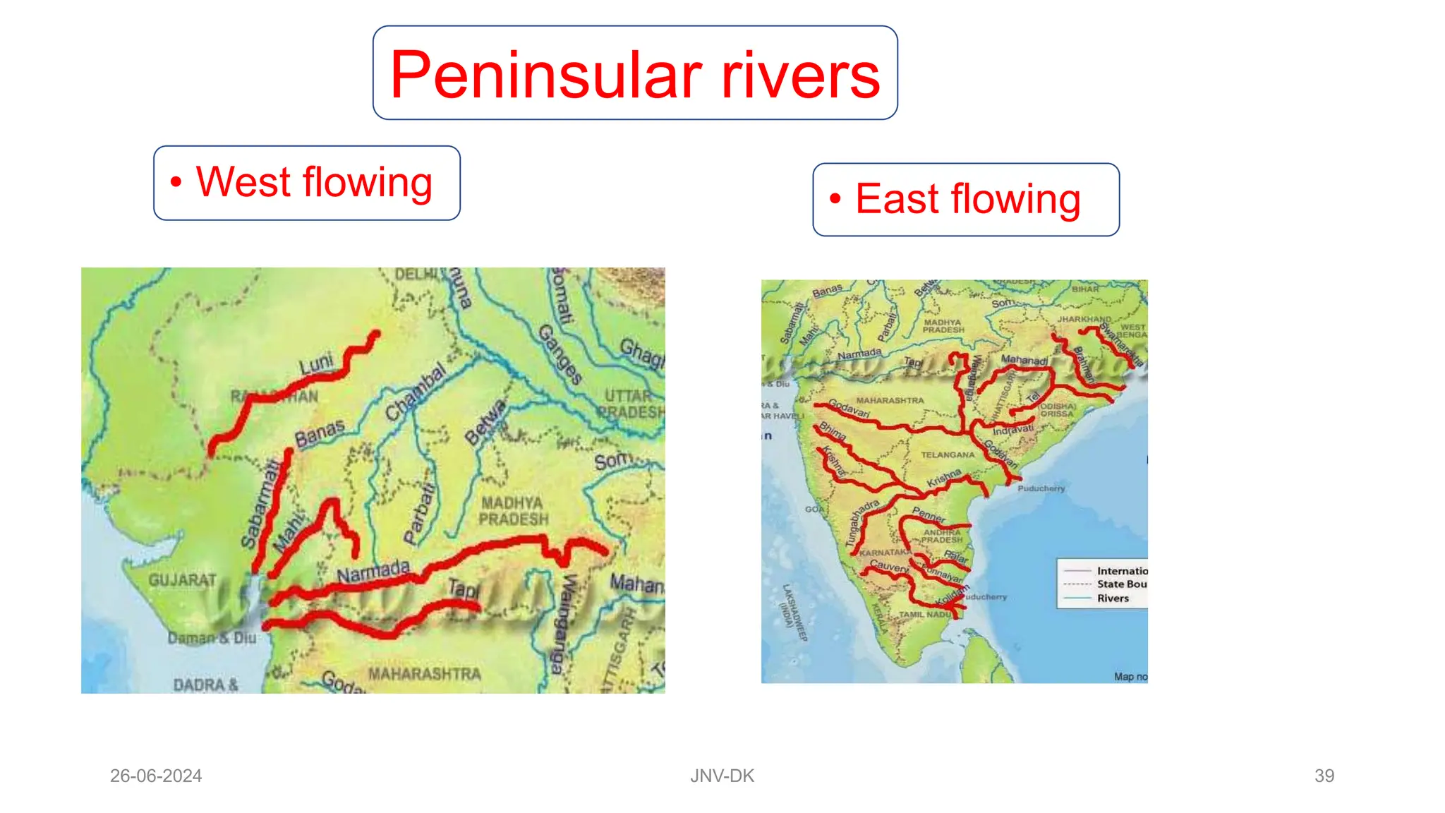
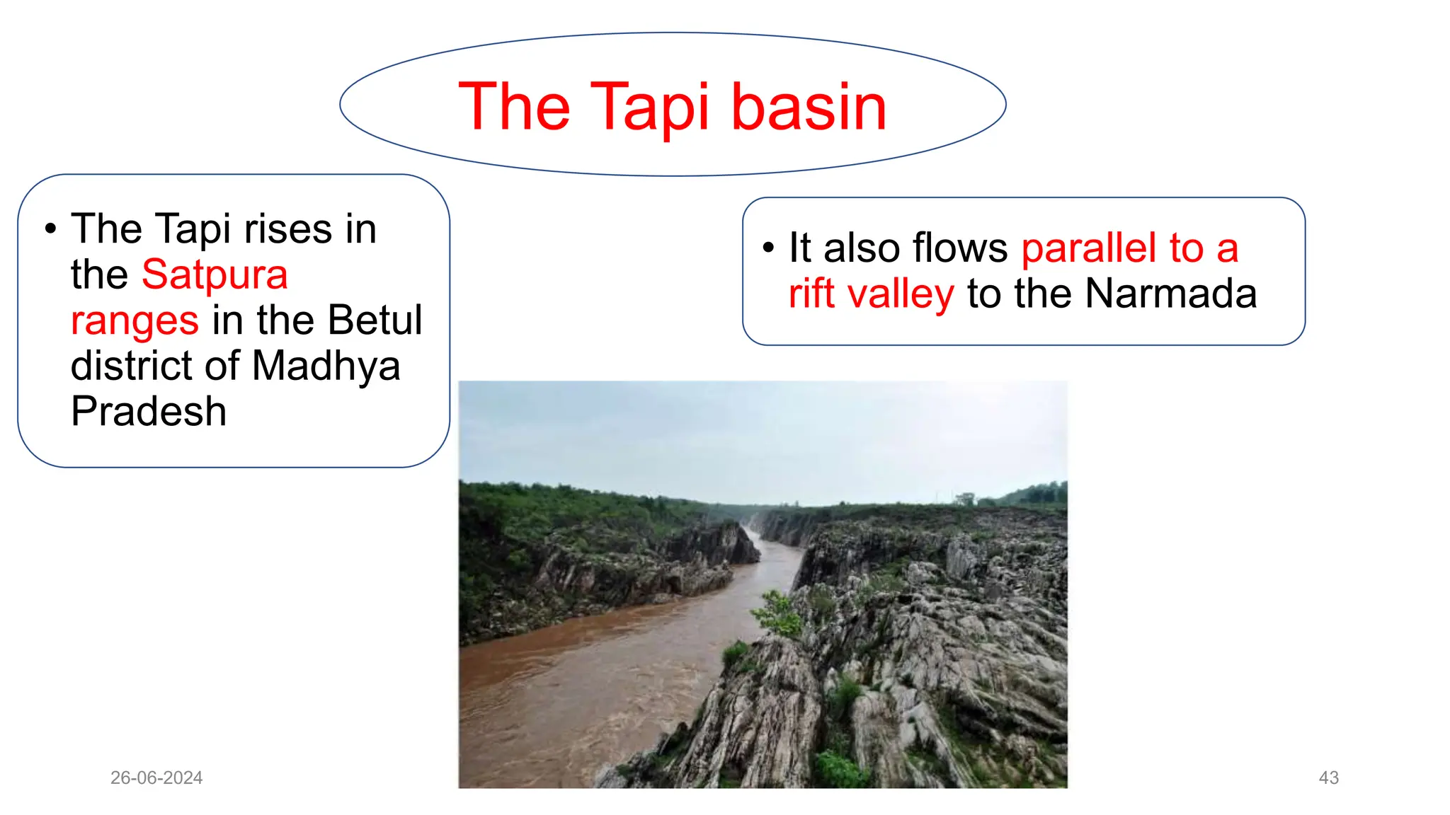
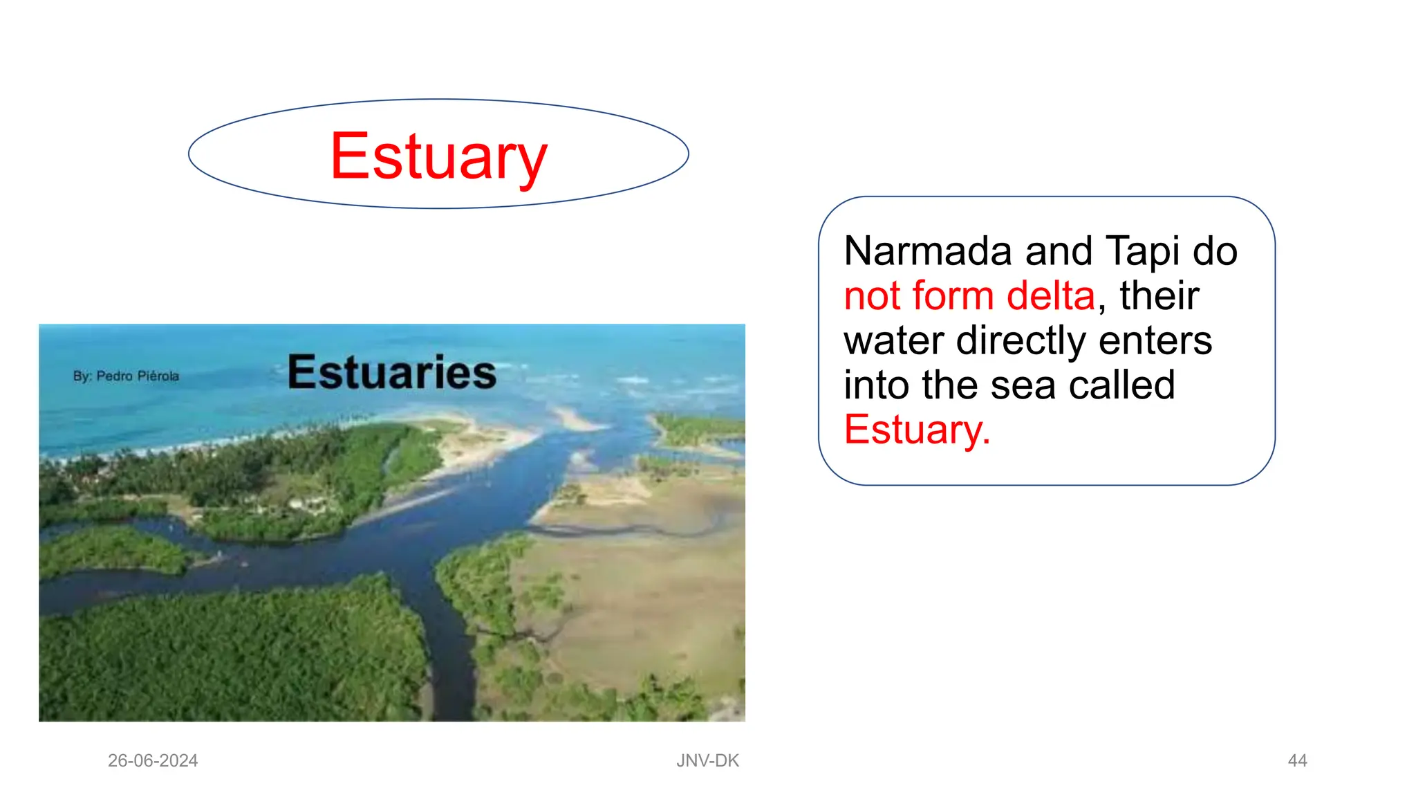
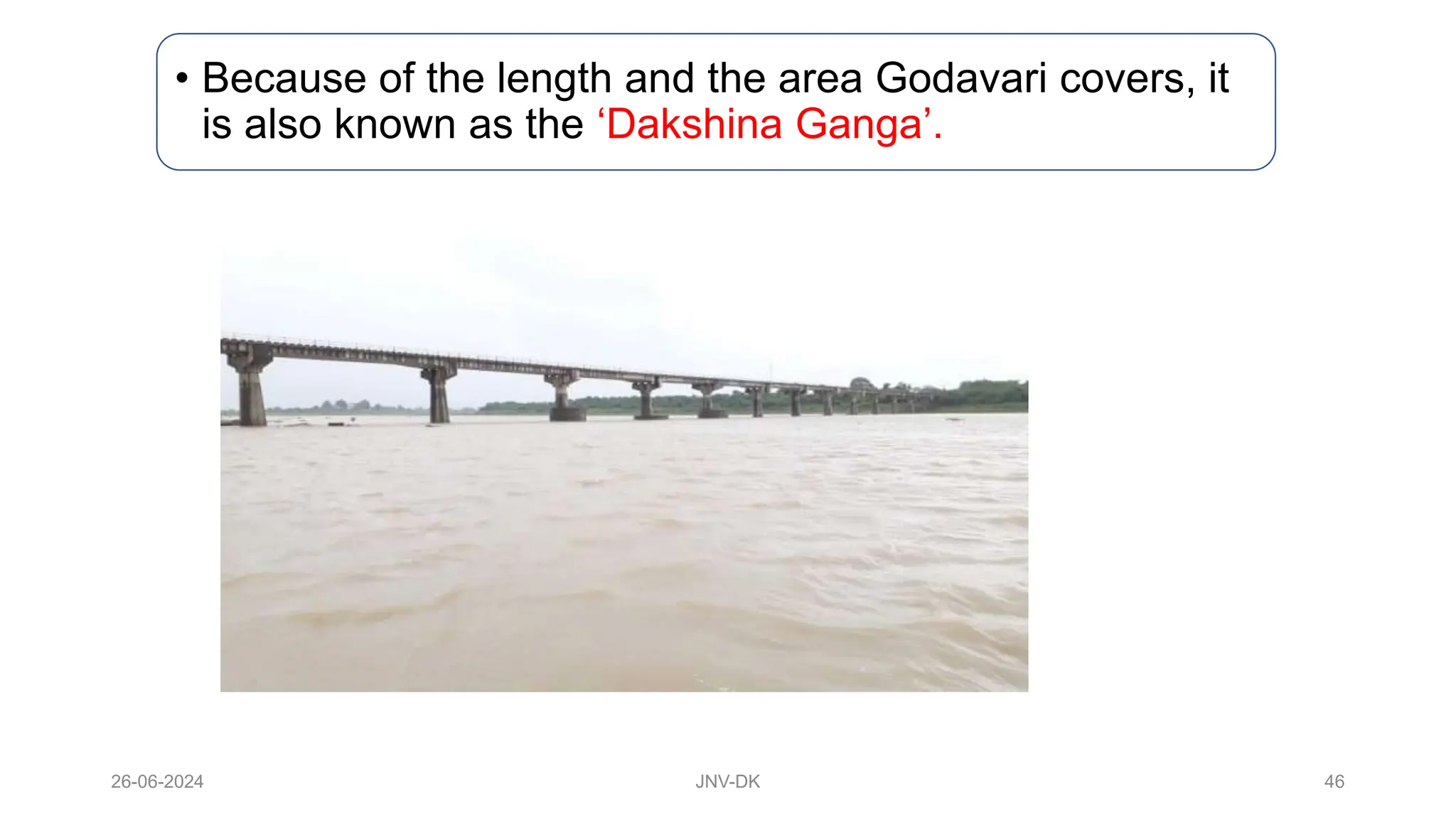
DRAINAGE
Class 9
26-06-2024 JNV-DK 1
Prepared by:
S.A.Rehman
PGT-Geography
JNV-Dakshina
Kannad, Karnataka
26-06-2024 JNV-DK 2
The term drainage describes the river system of an area.
26-06-2024 JNV-DK 3
The area drained by a single river system is called a drainage
basin.
26-06-2024 JNV-DK 4
A mountain or a upland area separating two drainage basins is
called water divide.
The world’s largest drainage basin is of the Amazon river
.
26-06-2024 JNV-DK 5
26-06-2024 JNV-DK 6
India’s largest drainage basin is of the Ganga river.
26-06-2024 JNV-DK 7
Drainage Systems in India
The Himalayan river system The Peninsular river system
26-06-2024 JNV-DK 8
Himalayan river system
Himalayan rivers are
perennial
They perform an
immense
erosional activity
in the upper
course.
Brahmaputra and
Indus make
gorges.
Carry huge loads of silt and sand
26-06-2024 JNV-DK 9
In the middle and
lower course they
form meanders,
oxbow lakes,
flood plains and
deltas.
Ganga, Indus and
Brahmaputra are the
major rivers.
26-06-2024 JNV-DK 10
Peninsular rivers They are
seasonal and
depend on
rainfall
Has short and
shallower course
Less erosional
activities in
upper course.
During dry
season it has
reduced flow of
water.
26-06-2024 JNV-DK 11
• Do not carry much
silt, so there are no
major plains. Land
is fertile only in
delta areas.
• The Mahanadi,
Godavari,
Krishna and
Kaveri originate
in western Ghats
and flows
towards Bay of
Bengal.
• The Narmada and
Tapi originate in
Central Highland
and flows towards
Arabian Sea.
26-06-2024 JNV-DK 12
A river has 3 stage-- Upper course, Middle course
and lower course
26-06-2024 JNV-DK 13
Drainage Pattern
The streams within a
drainage basin form
certain patterns,
depending on the
slope of land,
underlying rock
structures as well as
the climatic
conditions of the
area
There are 4 types of
drainage pattern
• 1. Dendritic
pattern
• 2. Trellis pattern
• 3. Rectangular
pattern
• 4. Radial pattern
26-06-2024 JNV-DK 14
Dendritic pattern
Develops where
the river channel
follows the slope of
the land.
• The streams and
its tributaries
resembles the
branches of a tree
26-06-2024 JNV-DK 15
Trellis pattern
• A river joined by its
tributaries, at approximately
right angles, develop a trellis
pattern.
26-06-2024 JNV-DK 16
Rectangular Pattern • A rectangular drainage
pattern develops on a
strongly jointed rocky
terrain.
26-06-2024 JNV-DK 17
Radial pattern
• The radial pattern
develops when
streams flow in
different directions
from a central peak or
dome like structure.
26-06-2024 JNV-DK 18
The Himalayan Rivers
• The major
Himalayan
rivers are the
Indus, the
Ganga and
the
Brahmaputra
.
• A river along with its
tributaries may be called
a river system.
26-06-2024 JNV-DK 19
Indus river system
26-06-2024 JNV-DK 20
Total length is 2900 kms,
originates near Manasarowar
lake in Tibet.
• Its important tributaries in Jammu
and Kashmir are the Zaskar,
Nubra, Shyok and the Hunza.
The other tributaries are
the Satluj, the Ravi, the
Beas, the Jhelum and the
Chenab joins Indus at
Mithankot in Pakistan.
• Drains into Arabian sea
of Karachi forming a
delta
26-06-2024 JNV-DK 21
• One third of the
Indus basin is
located in India in the
Union territories of
Ladakh and Jammu
and Kashmir, and in
the states of
Himachal Pradesh
and the Punjab.
26-06-2024 JNV-DK 22
• According to the
regulation of Indus Water
Treaty (1960) with
Pakistan, India can use
only 20% of the total
water carried by Indus
river system.
• This water is used
for irrigation in the
Punjab, Haryana
and the Rajasthan.
26-06-2024 JNV-DK 23
Ganga River system
26-06-2024 JNV-DK 24
Gaumukh- origin of Ganga
26-06-2024 JNV-DK 25
26-06-2024 JNV-DK 26
The Ganga river system
• Total length is 2500
kms.
• The headwaters of the
Ganga, called the ‘Bhagirathi
is fed by the Gangotri Glacier
and joined by the Alaknanda
at Devaprayag.
26-06-2024 JNV-DK 27
• The Yamuna, Ghaghara, Gandak
and Kosi are the major tributaries
from Himalayas.
• The river Yamuna rises from the Yamunotri
Glacier and meets the Ganga at Prayagraj.
26-06-2024 JNV-DK 28
• The main tributaries, which comes from the peninsular
uplands, are the Chambal, the Betwa and the Son.
26-06-2024 JNV-DK 29
• At Farakka in West Bengal, the Ganga enters into
Bangladesh.
26-06-2024 JNV-DK 30
• It joins with Brahmaputra
and known as Meghna.
• Together they form the
largest delta in the
world called ‘Sunderban
delta’.
26-06-2024 JNV-DK 31
• The Sundarban delta derived its name from the
Sundari tree which grows well in marshland.
• It is the world’s largest and fastest
growing delta. Its home to ‘Royal
Bengal Tiger’.
26-06-2024 JNV-DK 32
• Ganga conservation programme started by Union
government in 2014 with two objective.
• 1. Effective abatement of population
• 2. Conservation and rejuvenation of the national river.
The Namami Gange Progamme
26-06-2024 JNV-DK 33
Brahmaputra River System
26-06-2024 JNV-DK 34
• Rises in Tibet east of Mansarowar
lake.
• At Namcha Barwa it
takes a U-turn to
enter India in
Arunachal Pradesh
through a Gorge. In
Arunachal Pradesh it
is called Dihang.
• Dibang and the Lohit are its
important tributaries.
26-06-2024 JNV-DK 35
• In Tibet, the river carries a smaller volume of water and less
silt as it is a cold and a dry area.
26-06-2024 JNV-DK 36
• In India it passes through a region of high rainfall,
carries a large volume of water and silt.
26-06-2024 JNV-DK 37
• The Brahmaputra has a braided channel in its entire
length in Assam and forms many riverine islands.
• Majuli is the largest riverine island in the
world.
26-06-2024 JNV-DK 38
• Every year it causes devastating flood in Assam.
26-06-2024 JNV-DK 39
Peninsular rivers
• West flowing • East flowing
26-06-2024 JNV-DK 40
The Narmada Basin
• Narmada rises in the
Amarkantak hills in
Madhya Pradesh.
• Flows west in a rift valley
formed due to faulting.
26-06-2024 JNV-DK 41
Dhuadhar falls
Namami Devi Narmade
26-06-2024 JNV-DK 42
26-06-2024 JNV-DK 43
The Tapi basin
• The Tapi rises in
the Satpura
ranges in the Betul
district of Madhya
Pradesh
• It also flows parallel to a
rift valley to the Narmada
26-06-2024 JNV-DK 44
Estuary
Narmada and Tapi do
not form delta, their
water directly enters
into the sea called
Estuary.
26-06-2024 JNV-DK 45
The Godavari
• Largest peninsular river.
• Rises in the Nasik
district of
Maharashtra.
• Total length is 1500 km.
26-06-2024 JNV-DK 46
• Because of the length and the area Godavari covers, it
is also known as the ‘Dakshina Ganga’.
26-06-2024 JNV-DK 47
The Mahanadi
• Rises in the highlands of
Chhattisgarh.
• Total length is 860 km.
26-06-2024 JNV-DK 48
The Krishna
• Rise from a spring near Mahabaleshwar, the
Krishna flows for about 1400 km.
• The Tungabhadra,
the Koyana, the
Ghatprabha, the
Musi and the
Bhima are some of
its tributaries.
26-06-2024 JNV-DK 49
The Kaveri
• Rises in the Brahmagiri
range of the Western
Ghats.
• Total length is
760 km.
• Amravati, Bhavani, Hemavati
and Kabini are its important
tributaries.
26-06-2024 JNV-DK 50
River Kaveri makes the second biggest
waterfall in India- Sivasamudram
26-06-2024 JNV-DK 51
Jog falls is the biggest
waterfall in India.
26-06-2024 JNV-DK 52
Lakes
• A body of water that lies in a
hollow in the earth’s surface and
is surrounded by land.
26-06-2024 JNV-DK 53
• Lakes of large extent are
called the seas, like the
Caspian, the Dead sea and
the Aral sea.
26-06-2024 JNV-DK 54
26-06-2024 JNV-DK 55
26-06-2024 JNV-DK 56
• Lakes are formed
by the actions of
glacier, wind,
river action and
human activities.
• Lakes can be classified
as Salt water lake and
Fresh water lake or
natural lake and man-
made lake.
26-06-2024 JNV-DK 57
• A meandering river across a flood plain forms cut-offs that
later develop into ox-bow lakes.
26-06-2024 JNV-DK 58
• Spit and bars form lagoons in the coastal areas, eg the Chilika
lake, the Pulicat lake , the Kolleru lake.
26-06-2024 JNV-DK 59
• Lakes in the region of
Inland drainage are
sometimes seasonal, for
example, the Sambhar
lake in Rajasthan, which
is a salt water lake.
26-06-2024 JNV-DK 60
• Wular lake in Jammu and Kashmir, is a result of
tectonic activity
26-06-2024 JNV-DK 61
• Dams across
rivers has led to
the formation of
lakes called
man-made
lakes. Example
– Guru Gobind
Sagar (Bhakra
Nangal project)
26-06-2024 JNV-DK 62
Importance of
lakes
• Regulates the flow
of a river.
• Prevents flooding
during rainy
season.
• Maintains even
flow of water
26-06-2024 JNV-DK 63
• Used for developing
hydel power.
• Influence the climate of
the surrounding.
• Maintains aquatic
ecosystem.
• Enhance natural
beauty, develops
tourism.
26-06-2024 JNV-DK 64
Role of rivers in the economy
• Rivers have
attracted human
settlement from
ancient times.
• Today these
settlements have
become large cities.
• Used for irrigation,
navigation and hydro
power generation.
26-06-2024 JNV-DK 65
River Pollution
• The growing
domestic,
municipal,
industrial and
agricultural
demand for water
from rivers
naturally affects
the quality of
water.
26-06-2024 JNV-DK 66
• Heavy load of untreated sewage and industrial effluents
are emptied into the river causing pollution.
26-06-2024 JNV-DK 67
Urbanisation and industrialisation has also
contributed to the river pollution.
26-06-2024 JNV-DK 68
Thank You

chapter Drainage - geography class 9 NCERT

  • 1.
    DRAINAGE Class 9 26-06-2024 JNV-DK1 Prepared by: S.A.Rehman PGT-Geography JNV-Dakshina Kannad, Karnataka
  • 2.
    26-06-2024 JNV-DK 2 Theterm drainage describes the river system of an area.
  • 3.
    26-06-2024 JNV-DK 3 Thearea drained by a single river system is called a drainage basin.
  • 4.
    26-06-2024 JNV-DK 4 Amountain or a upland area separating two drainage basins is called water divide.
  • 5.
    The world’s largestdrainage basin is of the Amazon river . 26-06-2024 JNV-DK 5
  • 6.
    26-06-2024 JNV-DK 6 India’slargest drainage basin is of the Ganga river.
  • 7.
    26-06-2024 JNV-DK 7 DrainageSystems in India The Himalayan river system The Peninsular river system
  • 8.
    26-06-2024 JNV-DK 8 Himalayanriver system Himalayan rivers are perennial They perform an immense erosional activity in the upper course. Brahmaputra and Indus make gorges. Carry huge loads of silt and sand
  • 9.
    26-06-2024 JNV-DK 9 Inthe middle and lower course they form meanders, oxbow lakes, flood plains and deltas. Ganga, Indus and Brahmaputra are the major rivers.
  • 10.
    26-06-2024 JNV-DK 10 Peninsularrivers They are seasonal and depend on rainfall Has short and shallower course Less erosional activities in upper course. During dry season it has reduced flow of water.
  • 11.
    26-06-2024 JNV-DK 11 •Do not carry much silt, so there are no major plains. Land is fertile only in delta areas. • The Mahanadi, Godavari, Krishna and Kaveri originate in western Ghats and flows towards Bay of Bengal. • The Narmada and Tapi originate in Central Highland and flows towards Arabian Sea.
  • 12.
    26-06-2024 JNV-DK 12 Ariver has 3 stage-- Upper course, Middle course and lower course
  • 13.
    26-06-2024 JNV-DK 13 DrainagePattern The streams within a drainage basin form certain patterns, depending on the slope of land, underlying rock structures as well as the climatic conditions of the area There are 4 types of drainage pattern • 1. Dendritic pattern • 2. Trellis pattern • 3. Rectangular pattern • 4. Radial pattern
  • 14.
    26-06-2024 JNV-DK 14 Dendriticpattern Develops where the river channel follows the slope of the land. • The streams and its tributaries resembles the branches of a tree
  • 15.
    26-06-2024 JNV-DK 15 Trellispattern • A river joined by its tributaries, at approximately right angles, develop a trellis pattern.
  • 16.
    26-06-2024 JNV-DK 16 RectangularPattern • A rectangular drainage pattern develops on a strongly jointed rocky terrain.
  • 17.
    26-06-2024 JNV-DK 17 Radialpattern • The radial pattern develops when streams flow in different directions from a central peak or dome like structure.
  • 18.
    26-06-2024 JNV-DK 18 TheHimalayan Rivers • The major Himalayan rivers are the Indus, the Ganga and the Brahmaputra . • A river along with its tributaries may be called a river system.
  • 19.
  • 20.
    26-06-2024 JNV-DK 20 Totallength is 2900 kms, originates near Manasarowar lake in Tibet. • Its important tributaries in Jammu and Kashmir are the Zaskar, Nubra, Shyok and the Hunza. The other tributaries are the Satluj, the Ravi, the Beas, the Jhelum and the Chenab joins Indus at Mithankot in Pakistan. • Drains into Arabian sea of Karachi forming a delta
  • 21.
    26-06-2024 JNV-DK 21 •One third of the Indus basin is located in India in the Union territories of Ladakh and Jammu and Kashmir, and in the states of Himachal Pradesh and the Punjab.
  • 22.
    26-06-2024 JNV-DK 22 •According to the regulation of Indus Water Treaty (1960) with Pakistan, India can use only 20% of the total water carried by Indus river system. • This water is used for irrigation in the Punjab, Haryana and the Rajasthan.
  • 23.
  • 24.
  • 25.
  • 26.
    26-06-2024 JNV-DK 26 TheGanga river system • Total length is 2500 kms. • The headwaters of the Ganga, called the ‘Bhagirathi is fed by the Gangotri Glacier and joined by the Alaknanda at Devaprayag.
  • 27.
    26-06-2024 JNV-DK 27 •The Yamuna, Ghaghara, Gandak and Kosi are the major tributaries from Himalayas. • The river Yamuna rises from the Yamunotri Glacier and meets the Ganga at Prayagraj.
  • 28.
    26-06-2024 JNV-DK 28 •The main tributaries, which comes from the peninsular uplands, are the Chambal, the Betwa and the Son.
  • 29.
    26-06-2024 JNV-DK 29 •At Farakka in West Bengal, the Ganga enters into Bangladesh.
  • 30.
    26-06-2024 JNV-DK 30 •It joins with Brahmaputra and known as Meghna. • Together they form the largest delta in the world called ‘Sunderban delta’.
  • 31.
    26-06-2024 JNV-DK 31 •The Sundarban delta derived its name from the Sundari tree which grows well in marshland. • It is the world’s largest and fastest growing delta. Its home to ‘Royal Bengal Tiger’.
  • 32.
    26-06-2024 JNV-DK 32 •Ganga conservation programme started by Union government in 2014 with two objective. • 1. Effective abatement of population • 2. Conservation and rejuvenation of the national river. The Namami Gange Progamme
  • 33.
  • 34.
    26-06-2024 JNV-DK 34 •Rises in Tibet east of Mansarowar lake. • At Namcha Barwa it takes a U-turn to enter India in Arunachal Pradesh through a Gorge. In Arunachal Pradesh it is called Dihang. • Dibang and the Lohit are its important tributaries.
  • 35.
    26-06-2024 JNV-DK 35 •In Tibet, the river carries a smaller volume of water and less silt as it is a cold and a dry area.
  • 36.
    26-06-2024 JNV-DK 36 •In India it passes through a region of high rainfall, carries a large volume of water and silt.
  • 37.
    26-06-2024 JNV-DK 37 •The Brahmaputra has a braided channel in its entire length in Assam and forms many riverine islands. • Majuli is the largest riverine island in the world.
  • 38.
    26-06-2024 JNV-DK 38 •Every year it causes devastating flood in Assam.
  • 39.
    26-06-2024 JNV-DK 39 Peninsularrivers • West flowing • East flowing
  • 40.
    26-06-2024 JNV-DK 40 TheNarmada Basin • Narmada rises in the Amarkantak hills in Madhya Pradesh. • Flows west in a rift valley formed due to faulting.
  • 41.
  • 42.
  • 43.
    26-06-2024 JNV-DK 43 TheTapi basin • The Tapi rises in the Satpura ranges in the Betul district of Madhya Pradesh • It also flows parallel to a rift valley to the Narmada
  • 44.
    26-06-2024 JNV-DK 44 Estuary Narmadaand Tapi do not form delta, their water directly enters into the sea called Estuary.
  • 45.
    26-06-2024 JNV-DK 45 TheGodavari • Largest peninsular river. • Rises in the Nasik district of Maharashtra. • Total length is 1500 km.
  • 46.
    26-06-2024 JNV-DK 46 •Because of the length and the area Godavari covers, it is also known as the ‘Dakshina Ganga’.
  • 47.
    26-06-2024 JNV-DK 47 TheMahanadi • Rises in the highlands of Chhattisgarh. • Total length is 860 km.
  • 48.
    26-06-2024 JNV-DK 48 TheKrishna • Rise from a spring near Mahabaleshwar, the Krishna flows for about 1400 km. • The Tungabhadra, the Koyana, the Ghatprabha, the Musi and the Bhima are some of its tributaries.
  • 49.
    26-06-2024 JNV-DK 49 TheKaveri • Rises in the Brahmagiri range of the Western Ghats. • Total length is 760 km. • Amravati, Bhavani, Hemavati and Kabini are its important tributaries.
  • 50.
    26-06-2024 JNV-DK 50 RiverKaveri makes the second biggest waterfall in India- Sivasamudram
  • 51.
    26-06-2024 JNV-DK 51 Jogfalls is the biggest waterfall in India.
  • 52.
    26-06-2024 JNV-DK 52 Lakes •A body of water that lies in a hollow in the earth’s surface and is surrounded by land.
  • 53.
    26-06-2024 JNV-DK 53 •Lakes of large extent are called the seas, like the Caspian, the Dead sea and the Aral sea.
  • 54.
  • 55.
  • 56.
    26-06-2024 JNV-DK 56 •Lakes are formed by the actions of glacier, wind, river action and human activities. • Lakes can be classified as Salt water lake and Fresh water lake or natural lake and man- made lake.
  • 57.
    26-06-2024 JNV-DK 57 •A meandering river across a flood plain forms cut-offs that later develop into ox-bow lakes.
  • 58.
    26-06-2024 JNV-DK 58 •Spit and bars form lagoons in the coastal areas, eg the Chilika lake, the Pulicat lake , the Kolleru lake.
  • 59.
    26-06-2024 JNV-DK 59 •Lakes in the region of Inland drainage are sometimes seasonal, for example, the Sambhar lake in Rajasthan, which is a salt water lake.
  • 60.
    26-06-2024 JNV-DK 60 •Wular lake in Jammu and Kashmir, is a result of tectonic activity
  • 61.
    26-06-2024 JNV-DK 61 •Dams across rivers has led to the formation of lakes called man-made lakes. Example – Guru Gobind Sagar (Bhakra Nangal project)
  • 62.
    26-06-2024 JNV-DK 62 Importanceof lakes • Regulates the flow of a river. • Prevents flooding during rainy season. • Maintains even flow of water
  • 63.
    26-06-2024 JNV-DK 63 •Used for developing hydel power. • Influence the climate of the surrounding. • Maintains aquatic ecosystem. • Enhance natural beauty, develops tourism.
  • 64.
    26-06-2024 JNV-DK 64 Roleof rivers in the economy • Rivers have attracted human settlement from ancient times. • Today these settlements have become large cities. • Used for irrigation, navigation and hydro power generation.
  • 65.
    26-06-2024 JNV-DK 65 RiverPollution • The growing domestic, municipal, industrial and agricultural demand for water from rivers naturally affects the quality of water.
  • 66.
    26-06-2024 JNV-DK 66 •Heavy load of untreated sewage and industrial effluents are emptied into the river causing pollution.
  • 67.
    26-06-2024 JNV-DK 67 Urbanisationand industrialisation has also contributed to the river pollution.
  • 68.