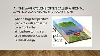
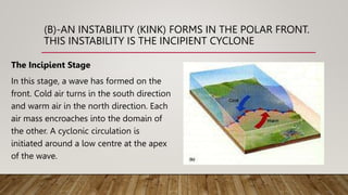
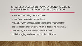
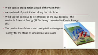
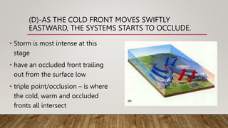
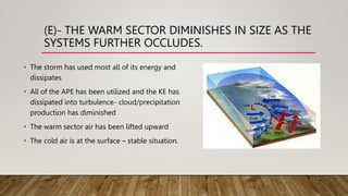
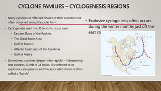
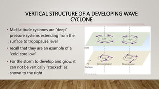
DEVELOPMENT AND
EVOLUTION OF A WAVE
CYCLONE
(A)- THE WAVE CYCLONE (OFTEN CALLED A FRONTAL
WAVE) DEVELOPS ALONG THE POLAR FRONT
• When a large temperature
gradient exists across the
polar front – the
atmosphere contains a
large amount of Available
Potential Energy
(B)-AN INSTABILITY (KINK) FORMS IN THE POLAR FRONT.
THIS INSTABILITY IS THE INCIPIENT CYCLONE
The Incipient Stage
In this stage, a wave has formed on the
front. Cold air turns in the south direction
and warm air in the north direction. Each
air mass encroaches into the domain of
the other. A cyclonic circulation is
initiated around a low centre at the apex
of the wave.
(C))-A FULLY-DEVELOPED “WAVE CYCLONE” IS SEEN 12-
24 HOURS FROM ITS INCEPTION. IT CONSISTS OF:
• A warm front moving to the northeast
• a cold front moving to the southeast
• region between warm and cold fronts is the “warm sector”
• the central low pressure (low, which is deepening with time)
• overrunning of warm air over the warm front
• cold air surging southward behind the cold front
• Wide-spread precipitation ahead of the warm front
• narrow band of precipitation along the cold front
• Wind speeds continue to get stronger as the low deepens – the
Available Potential Energy (APE)is being converted to Kinetic Energy
(KE)
• The production of clouds and precipitation also generates
energy for the storm as Latent Heat is released
(D)-AS THE COLD FRONT MOVES SWIFTLY
EASTWARD, THE SYSTEMS STARTS TO OCCLUDE.
• Storm is most intense at this
stage
• have an occluded front trailing
out from the surface low
• triple point/occlusion – is where
the cold, warm and occluded
fronts all intersect
(E)- THE WARM SECTOR DIMINISHES IN SIZE AS THE
SYSTEMS FURTHER OCCLUDES.
• The storm has used most all of its energy and
dissipates
• All of the APE has been utilized and the KE has
dissipated into turbulence- cloud/precipitation
production has diminished
• The warm sector air has been lifted upward
• The cold air is at the surface – stable situation.
CYCLONE FAMILIES – CYCLOGENESIS REGIONS
• Many cyclones in different phases of their evolution are
often observed along the polar front
• Cyclogenesis over the US tends to occur near:
• Eastern Slope of the Rockies
• The Great Basin Area
• Gulf of Mexico
• Atlantic Coast east of the Carolinas
• Gulf of Alaska
• Sometimes, cyclones deepen very rapidly – if deepening
rate exceeds 24 mb in 24 hours, it is referred to as
explosive cyclogenesis and the associated storm is often
called a “bomb”
• Explosive cyclogenesis often occurs
during the winter months just off the
east coast of the US
VERTICAL STRUCTURE OF A DEVELOPING WAVE
CYCLONE
• Mid-latitude cyclones are “deep”
pressure systems extending from the
surface to tropopause level
• recall that they are an example of a
“cold core low”
• For the storm to develop and grow, it
can not be vertically “stacked” as
shown to the right
Development and Evolution of Wave Cyclone.pptx

Development and Evolution of Wave Cyclone.pptx

  • 1.
  • 2.
    (A)- THE WAVECYCLONE (OFTEN CALLED A FRONTAL WAVE) DEVELOPS ALONG THE POLAR FRONT • When a large temperature gradient exists across the polar front – the atmosphere contains a large amount of Available Potential Energy
  • 3.
    (B)-AN INSTABILITY (KINK)FORMS IN THE POLAR FRONT. THIS INSTABILITY IS THE INCIPIENT CYCLONE The Incipient Stage In this stage, a wave has formed on the front. Cold air turns in the south direction and warm air in the north direction. Each air mass encroaches into the domain of the other. A cyclonic circulation is initiated around a low centre at the apex of the wave.
  • 4.
    (C))-A FULLY-DEVELOPED “WAVECYCLONE” IS SEEN 12- 24 HOURS FROM ITS INCEPTION. IT CONSISTS OF: • A warm front moving to the northeast • a cold front moving to the southeast • region between warm and cold fronts is the “warm sector” • the central low pressure (low, which is deepening with time) • overrunning of warm air over the warm front • cold air surging southward behind the cold front
  • 5.
    • Wide-spread precipitationahead of the warm front • narrow band of precipitation along the cold front • Wind speeds continue to get stronger as the low deepens – the Available Potential Energy (APE)is being converted to Kinetic Energy (KE) • The production of clouds and precipitation also generates energy for the storm as Latent Heat is released
  • 6.
    (D)-AS THE COLDFRONT MOVES SWIFTLY EASTWARD, THE SYSTEMS STARTS TO OCCLUDE. • Storm is most intense at this stage • have an occluded front trailing out from the surface low • triple point/occlusion – is where the cold, warm and occluded fronts all intersect
  • 7.
    (E)- THE WARMSECTOR DIMINISHES IN SIZE AS THE SYSTEMS FURTHER OCCLUDES. • The storm has used most all of its energy and dissipates • All of the APE has been utilized and the KE has dissipated into turbulence- cloud/precipitation production has diminished • The warm sector air has been lifted upward • The cold air is at the surface – stable situation.
  • 8.
    CYCLONE FAMILIES –CYCLOGENESIS REGIONS • Many cyclones in different phases of their evolution are often observed along the polar front • Cyclogenesis over the US tends to occur near: • Eastern Slope of the Rockies • The Great Basin Area • Gulf of Mexico • Atlantic Coast east of the Carolinas • Gulf of Alaska • Sometimes, cyclones deepen very rapidly – if deepening rate exceeds 24 mb in 24 hours, it is referred to as explosive cyclogenesis and the associated storm is often called a “bomb” • Explosive cyclogenesis often occurs during the winter months just off the east coast of the US
  • 9.
    VERTICAL STRUCTURE OFA DEVELOPING WAVE CYCLONE • Mid-latitude cyclones are “deep” pressure systems extending from the surface to tropopause level • recall that they are an example of a “cold core low” • For the storm to develop and grow, it can not be vertically “stacked” as shown to the right