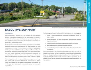
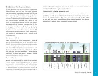
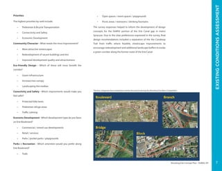
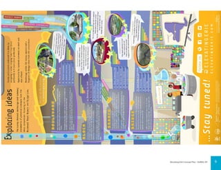
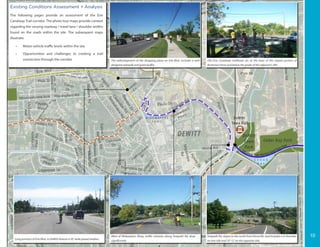
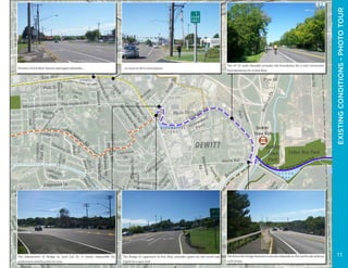
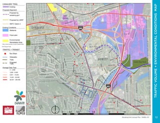
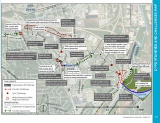
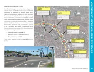
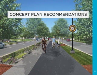
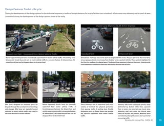
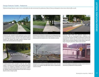
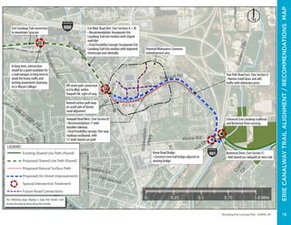
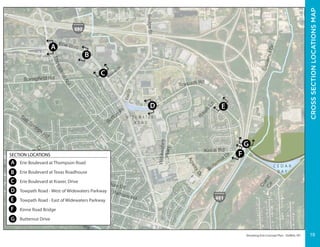
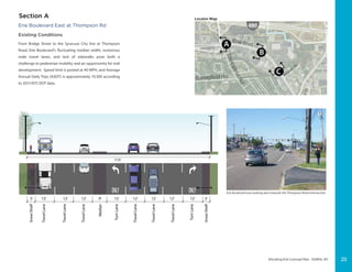
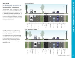
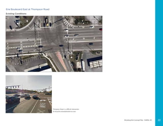
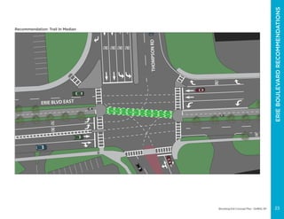
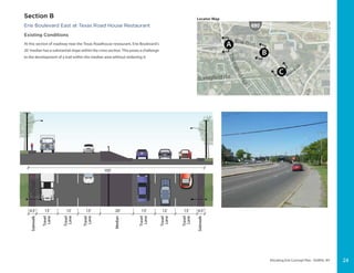
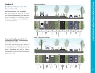
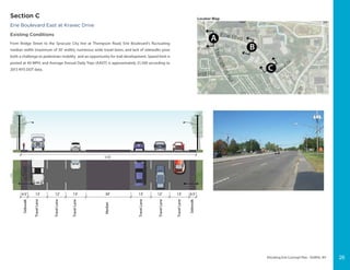
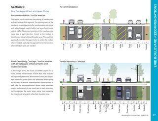
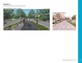
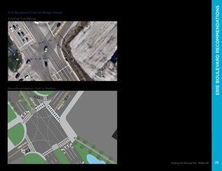
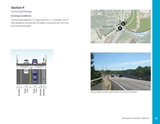
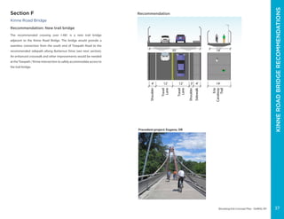
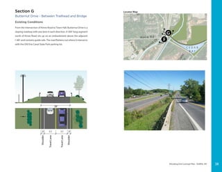
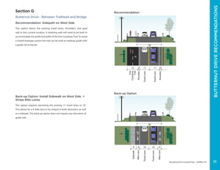
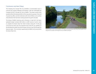
The document presents the Elevating Erie Concept Plan, which seeks to create a multi-use trail along the former Erie Canal alignment through the Town of DeWitt. The plan's goals are to provide recreational opportunities, increase transportation options, improve economic development, and brand DeWitt as more sustainable. The proposed trail would extend the existing Erie Canalway Trail through DeWitt along roads and boulevards to link with the trail in Camillus, closing a 14-mile gap. Recommendations include a shared-use path in the median of Erie Boulevard, bicycle lanes on Towpath Road, and a new bridge over I-481 to connect to Old Erie Canal State Park.
Oct. 19 Complete Streets Open House BoardsCityofBoulder
The Transportation Master Plan aims to create a multimodal transportation system that meets sustainability goals and provides more options for walking, biking, and transit. It sets targets of 20% of trips by walking, biking, or transit by 2035. The plan identifies several projects to make streets more accommodating for all users, including improving safety at intersections, adding bicycle facilities, and enhancing pedestrian crossings. Public input helped define transportation priorities and potential projects along major corridors like Arapahoe Avenue and 28th Street to create safer, more accessible routes for all.
The document summarizes proposed enhancements to the Harbor Bridge Project in Corpus Christi, Texas. It describes enhancements that will improve mobility and connectivity to areas near the port, SEA district, and downtown, including an emphasis on bicycle and pedestrian access and aesthetic features. Specifically, it notes that the enhancements will eliminate six traffic signals to create free-flowing gateways, improve port and refinery access, and enhance the North Beach area with safer connections and a shared use path. The enhancements are part of an ongoing design-build process to achieve the best results for the community.
Clifton Ave Streetscape Report- Spring 2015.compressedJake Henderson
The document summarizes a proposal to redesign Clifton Avenue in Cincinnati, Ohio to improve walkability, connectivity, and balance different transportation modes. The proposal was created by Jake Henderson, Stephanie Godsey, and Nicole Dibble. It includes an analysis of the existing conditions, design criteria focused on balance, safety and eco-design, a proposed street section, master plan and renderings of the redesign. The goal is to transform Clifton Avenue from an automobile-dominated corridor into a multi-modal public space that better connects surrounding neighborhoods and institutions.
Public Information Meeting: Realignment of Old Courthouse Road at Besley RoadFairfax County
This document summarizes a public information meeting held by the Fairfax County Department of Transportation regarding the realignment of Old Courthouse Road at Besley Road. The meeting covered project progress updates, revised roadway and bridge designs, hydrologic and hydraulic analysis of the new bridge structure, maintenance of traffic plans during construction, projected costs and schedule, and a question and answer session. Traffic on Besley Road will be detoured for approximately 6 months onto nearby roads. The adjacent communities will be notified of traffic changes through various means with advanced notice.
CPR Yards Crossing Study - open house panelsCrowdbrite
CPR Yards Crossing Study
Welcome to our open house
Today we’re talking about ideas to replace the
Arlington Street Bridge and improve crossings over the
CPR Yards. We look forward to hearing your views.
The Sunset Hills Road Walkway project in Fairfax County, VA was substantially completed on May 2, 2016. The project included constructing 1,570 feet of pedestrian walkway and curb ramps, installing 136 feet of stormwater pipe and structures, resurfacing 303 feet of the W&OD trail, and adding a rest area with bench and water fountain and two bus pads for future bus service. The project was led by the Department of Transportation and Utilities Design and Construction Division of Fairfax County.
The document discusses options for connecting the Brooklyn Bridge Park Greenway bike path through the Fulton Ferry Plaza area. It analyzes 3 alternatives: 1) Keeping the path in the park, 2) Improving DOT bike lanes on Old Fulton Street, or 3) An on-street separated path along the park curb. The recommended option combines alternatives 1 and 2, providing a choice for cyclists to use an in-park path or DOT lanes. Next steps include signage improvements and understanding future redevelopment plans.
Slides related to Bushaway Neighborhood organizing against large-scale widening of the Bushaway Rd (Co. Rd. 101 in Wayzata, Minnesota) by Hennepin County. Photos show beauty of historic Bushaway Rd and destruction of trees and homes by County in other sections of Co. Rd. 101
The document summarizes the Cermak/Blue Island Sustainable Streetscape project in Chicago. The project aims to create a more sustainable streetscape through strategies like permeable pavements, bioswales, LED lighting, and expanding tree cover to reduce urban heat island effect. It also discusses monitoring various sustainability metrics and engaging the community through education. The streetscape integrates designs for stormwater management, energy efficiency, air quality, and more to demonstrate sustainable infrastructure.
This is a 2004 report on the feasibility of a Trans Canada Trail route between Cranbrook and Yahk. Other routing options were eventually decided on, however this route option has the potentail to be a connecting spur trail to the TCT at Cranbrook. Refer to CranbrookYahkNorthMap and CranbrookYahkSouthMap for identifying segments found in this report.
The document proposes transforming Clifton Avenue from an automobile-dominated corridor into a multi-modal public space using principles of balance, safety, and eco-design. The proposal would include widened sidewalks, bike lanes, traffic calming measures like a raised median and narrower lanes to slow traffic, and green infrastructure like bioswales and trees to manage stormwater runoff in a self-sustaining manner. The goal is to improve connectivity between Burnet Woods, the university, and surrounding neighborhoods while creating a more comfortable environment for all users.
The document discusses two light rail projects - the Green Line Extension in Boston and the Honolulu Rail Transit Project. It provides details on the design and construction of the elevated light rail structures for each project, including the use of steel and concrete viaducts, bridges, and stations. Both projects aim to alleviate traffic congestion through expanded public transportation options and intermodal connectivity.
The SFMTA document summarizes the key roles and goals of the San Francisco Municipal Transportation Agency (SFMTA). The SFMTA is responsible for operating Muni and overseeing transportation in San Francisco. It aims to improve safety, promote sustainable transportation like transit and biking, enhance the environment, and deliver excellent services. The agency manages various modes of transit that serve over 700,000 passengers daily. Future plans outlined in other documents aim to enhance regional connectivity and upgrade various transit lines through projects like the Central Subway extension and Transbay Transit Center. The unique terrain, limited space, earthquake risk, and public support for sustainability have shaped San Francisco's transit-oriented development.
Sandon Rogers and Helen Gabriel of the City of Suffolk Public Works Department and Parks & Recreation received awards from the American Public Works Association for two projects. Rogers received an award for intersection improvement projects on Bridge Road and Bennetts Pasture Road/Bridge Road and Lee Farm Lane. Rogers and Gabriel received an honorable mention for the Suffolk Seaboard Coastline Trail, an 11-mile multiuse trail. The projects improved safety and traffic flow as well as providing a recreational asset. Rogers and Gabriel will be recognized at the APWA Mid-Atlantic Chapter's annual conference in May.
Georgetown Pike at Dolley Madison Blvd Pedestrian Improvements July 2020 july...Fairfax County
This document provides details about a pedestrian improvement project at the intersection of Georgetown Pike and Dolley Madison Boulevard in Fairfax County, Virginia. The project involved installing sidewalks, shared use trails, and drainage improvements. A contractor completed the work, which included grading areas for the new paths and sidewalks, installing concrete and asphalt, and replacing an existing stormwater pipe. Photos show the improvements which enhanced pedestrian safety and accessibility at the intersection.
The document proposes a draft expenditure plan for a $5 million Navy mitigation fund in Contra Costa County. The plan updates a 1991 plan by proposing several new transportation and trail projects that meet the fund's goals of restoring transportation links and waterfront access. The draft plan allocates funding to projects like road improvements, pedestrian/bicycle trails, trail landscaping and planning for a regional trail connecting multiple cities. The plan aims to balance project types and fully or partially fund relatively inexpensive projects that can be completed in the next few years.
Walton Boulevard Reconstruction, APWA Project of the YearOHM Advisors
http://www.ohm-advisors.com. An APWA award-winning project, reconstructing Walton Boulevard, in the City of Auburn Hills, was no easy task. Start with 1.5 miles of road, an old bridge over a major freeway, and three government owners. Then, throw in high priority federal and state funding deadlines and a five month schedule to complete. No problem. If you're OHM, and you're committed to Advancing Communities!
Rollins Pass Road: Public Input Boulder County Public Hearing - February 13, ...COHVCO
Request by Gilpin and Grand Counties to open road based on language included in Public Law 107-216 – the James Peak Wilderness and Protection Area Act.
• Boulder County Commissioners have expressed concerns about opening the Rollins Pass Road
including
• The difficulty and expense in making the road and tunnel safe
• Liability for injury resulting in use of the road and/or tunnel
• Protection of the fragile high alpine ecosystem in the area
• The purpose of today’s hearing is to gather public input on this request
The City of San Diego hosted a scoping meeting in preparation of a Program EIR for the Balboa Avenue Station Area Specific Plan.
The public scoping meeting was held by the City of San Diego’s Planning Department on Tuesday, July 18th, from 6:00 PM to 7:45 PM at the Pacific Beach Taylor Branch Library located at 4275 Cass Street, San Diego, CA, 92109. The scoping meeting was conducted in a workshop format where staff provided a brief PowerPoint presentation to the public about the project scope, and the environmental issues to be analyzed in the PEIR. Written public comments were accepted.
USACE National Award of Excellance-Tailrace LaunchMichael Lowe
The Roanoke River Basin Association's Upper Reach Program has been selected as the recipient of the 2014 U.S. Army Corps of Engineers national Excellence in Partnership Award for their efforts in providing eco-tourism, recreational therapy, and environmental education through their universally accessible canoe and kayak launch project, which has created new recreational opportunities. The launch was designed by Upper Reach Program Director Scott Murray and built through collaboration between the Upper Reach Program and the U.S. Army Corps of Engineers to improve access to waterways for people of all abilities. This partnership has expanded recreation and education around the Roanoke River and resulted in additional launches being constructed.
Clairemont CPG Ad Hoc Subcommittee MeetingCirculateSD
On Tuesday, May 10, 2016, the project team presented on the study area's existing condition to the Clairemont Community Planning Group Ad Hoc Subcommittee.
This Project Study Report proposes alternatives to retrofit and widen the A-Street Bridge to accommodate increased traffic from a new housing development, McKinley Village. Three alternatives were considered: Alternative 1 adds a Class I bike path, Alternative 2 adds Class II bike lanes on each side, and Alternative 3 is a "no build" option keeping the existing Class III bike route. Alternative 1 was selected to provide separated facilities for bicyclists and pedestrians. The retrofit would widen the bridge by 16 feet to include a 6-foot sidewalk, 12-foot lanes, and a two-way Class I bike path. Additional right-of-way and modifications to bridge supports and abutments would be required. The project
East Cowes - Proposed development - Solent Gateways - Dec 2014onthewight
The document proposes improvements to connectivity between Southampton and the Isle of Wight through the Solent Gateways project. This includes enhancing the public areas around the Red Funnel ferry terminals in East Cowes and Southampton to improve the transport interchanges and stimulate regeneration. Specific proposals for East Cowes include upgrading Bridge Square, York Square, and Trinity Wharf near the ferry terminal with new public spaces, pedestrian priority areas, and a cohesive waterfront design using materials like stone, timber and steel. The project aims to complete an existing masterplan and improve traffic flow, public transport access, and the quality of the town center environment.
"West Houston (TX): An introduction to the plan that links people, places and communities."
Read along: http://www.energycorridor.org/…/med…/parks/WHTMP-8-Pager.pdf
Photo credit: The Energy Corridor, Houston TX.
Master Plan for the Erie, PA Bayfront, prepared for the Erie Western-Pennsylvania Port Authority by Domokur Architects. Note this is a public document paid for by tax funds, and available at http://www.porterie.org/assets/021909_Erie%20Waterfront_Public%20Mtg%202.pdf.
Uploaded for the purpose of embedding in the site, www.YourNextDevelopment.com to enable real estate developers to complete due diligence in reviewing a property in Erie, PA.
Dead Run Force Main Rehabilitation ProjectFairfax County
The document summarizes a project to rehabilitate an existing 14-inch cast iron force main in Fairfax County, Virginia. The project involved lining the 2,700 linear feet of force main with cured-in-place pipe lining, installing storm culverts under five driveways to improve drainage, replacing an existing concrete culvert, restoring ditches and driveways, and adding safety measures. The project was substantially completed in September 2016 to repair the 60-year old force main running from Dead Run Drive to Dolly Madison Boulevard.
Gardiner East EA Public Forum 3 (Feb062014) - panelsGardinerEast
The document provides an overview of the Future of the Gardiner East Environmental Assessment and Urban Design Study. It discusses:
- The study area, which is the section of the Gardiner Expressway East/Lake Shore Boulevard extending from west of Lower Jarvis Street to Leslie Street.
- The goals of the study, which are to revitalize the waterfront, reconnect the city with the lake, balance modes of travel, achieve sustainability, and create value.
- Consultation activities conducted so far, including stakeholder meetings, public forums, online engagement, and social media, engaging over 5,000 individuals.
Rails to-green rails green space is the future for rail stations and rail cor...Dania Abdel-aziz
This document discusses the conversion of abandoned rail corridors into public trails, known as "rails-to-trails". It provides examples of successful rails-to-trails projects and outlines the benefits of converting unused rail lines into multi-use trails. Specifically, it discusses how rails-to-trails projects have recycled abandoned infrastructure to provide recreational and transportation benefits, while preserving natural landscapes and historical artifacts. Over 35 years, more than 13,000 miles of rail-trails have been created in the US, with over 100 million annual users, demonstrating how reusing old rail corridors can reconnect communities and provide environmental and health benefits.
Gardiner East EA - Public Forum 5 PanelsGardinerEast
The document discusses the Future of the Gardiner East Environmental Assessment and Urban Design Study being conducted by Waterfront Toronto. It provides background on the study area along Lake Shore Boulevard and the Gardiner Expressway from Lower Jarvis Street to Leslie Street. The study includes developing and evaluating alternative designs for the Hybrid option endorsed by City Council in 2015. It outlines the work completed since June 2015, including developing three Hybrid Design Alternative concepts and evaluating them. It also discusses the goals and principles guiding the study to revitalize the waterfront, reconnect the city to the lake, balance transportation modes, achieve sustainability, and create value.
In early 2015, the Schuylkill River Development Corporation (SRDC) sought professional service proposals for a study to determine the general feasibility of extending the Schuylkill River Trail (Schuylkill Banks) south along the river from the end of the Bartram’s Mile project near 56th Street to the Passyunk Crescent Park (proposed) at the Passyunk Avenue Bridge (Figure 1). The selected Study Team, made up of KSK Architects Planners Historians, Inc. (KSK), Urban Engineers, Inc. (Urban), and Conservation Matters, LLC, prepared the SRDC Schuylkill River Trail Feasibility Study, Bartram’s to Passyunk. The study has been prepared in general conformance with the Lower Schuylkill Master Plan issued by the Philadelphia Industrial Development Corporation (PIDC), Philadelphia City Planning Commission, and the Philadelphia Department of Commerce. The goal of this important project is to continue moving towards the completion of the Schuylkill River Trail.
Citizens Vision - Cleveland OH Scranton Peninsula River JewelR Ray Saikus
Proposal for a channel along the Cuyahoga River in Cleveland Ohio at the base of the Scranton Peninsula to improve commercial navigation and free up 1 mile of river for continuous public use and more public access time all along the length of the river. An infrastructure shovel ready project with many short and long term benefits for Cleveland and the region. Reduced dredging benefits the environment.
GuidryNews.com_Columbia Tap Hike and Bike Trail 2011Jose Enriquez
The Columbia Tap Trail in Houston, which is a 4-mile hike and bike path, has reopened after being closed for construction of METRO's Southeast light-rail line. METRO has made improvements to the trail including new landscaping and irrigation. The light-rail line is expected to open in 2014 and will connect downtown Houston to local universities. METRO worked to reopen the trail as quickly as possible while maintaining access for bicyclists during construction of the nearby light-rail project.
Kingston Greenline & Ulster County Trails Summit - Summit PresentationThe Kingston Land Trust
The Kingston Greenline & Ulster County Trails Summit was made possible with funding from the Land Trust Alliance's Conservation Partnership Catalyst Grant Program. The Summit included a keynote presentation from Jeff Olson, author of The Third Mode and principal with Alta Planning + Design. Lindsay Zefting, planner and engineer with Alta Planning + Design presented the final report for the Kingston Point Rail Trail Feasibility Study. A panel comprising representatives from the Kingston Land Trust, Ulster County Planning, the Hudson River Valley Greenway and Parks & Trails NY discussed the emerging trail network in Ulster County.
The document proposes developing a multi-use recreational trail from Kingston to the Ashokan Reservoir that would connect the city to open spaces, increase tourism, promote healthy lifestyles, and expand transportation alternatives. It discusses the project vision and goals, background history of the rail corridor, potential linkages to other trails, sections of the proposed trail, steps to address issues in developing the trail, and potential partners to help realize the project.
Take Me to the River Phase II is a community design study for the neighborhoods of West Harlem and Washington Heights completed in 2009. The study was done in partnership with the West Harlem Art Fund and the Office of the Manhattan Borough President and financially sponsored by NY Department of State, Division of Coastal Resources
Genesee Valley Greenway State Park - HistoryJoan Schumaker
This show covers canal and railroad history of the historic transportation corridor that transitioned to the Genesee Valley Greenway and now the GVGSP, New York State's newest linear park.
The document describes several projects designed and managed by DiFrank including:
1) The Croke Reservoir Urban Shoreline Project in Northglenn, CO which enhanced connectivity and provided social gathering areas around the reservoir.
2) Concept designs for gateways and streetscapes at the University of Nebraska, Kearney campus focusing on identity, pedestrian safety, and traffic flows.
3) Capital improvements and a site management plan for the 1,200-acre Boulder Reservoir Park in Boulder, CO including a new entry project, infrastructure upgrades, and management strategies.
4) The design of a high-end residential development called Luxe Lake Parcel Y3 in Chengdu, China focused on
The slide presentation was created by graduate students from Kent State University's Cleveland Urban Design Collaborative for the Port of Conneaut and City of Conneaut, Ohio. Developed with stakeholder input over the course of a fast-paced, three day weekend, the preliminary design recommendations provide an overall vision for Conneaut's Lakefront, Downtown, Route 7 Corridor, and Regional Connections. The initial concepts shown in the presentation will require further public feedback and careful design development before specific implementation plans can be made, but serve as an important step towards realizing Conneaut's future as a thriving waterfront community. For more information on the project, please contact the CUDC at www.cudc.kent.edu.
INFRASTRUCTURE DEVELOPMENT AND THE GROWTH OF CHICAGO5.docxjaggernaoma
INFRASTRUCTURE DEVELOPMENT AND THE GROWTH OF CHICAGO 5
Infrastructure Development and the Growth of Chicago
05/11/2018
Infrastructure Development and the Growth of Chicago
Transport infrastructure is a sign of growth and development of a town or city. Chicago is such city that focused on transport infrastructure to ensure the growth of the city. Before transport infrastructure improvement, Judge Jesse B. Thomas complained that Chicago was “merely the center of local retail trade of a few hundred miles of extent” (Cronon, 2009, p.63). The government through it planners and other professionals speculated that the provision of proper infrastructure would improve economic growth and break the banks guarding economic hinterland of Chicago. The canal was the first attempt to build artificial corridors connecting Chicago to Illinois. The canal became busy, and farmers opted for water transport rather than using the muddy roads. Chicago thrived because the farmers bought more urban manufactured goods and brought corn to the city. Soon, the railroads were developed and took over the canals and barges, increasing the development of the city in many ways. The newer modes of transport helped Chicago grow not only in the catchment area but also its infrastructure, the flow of goods and urban metabolism. Comment by Teacher: Repetitive Comment by Teacher: Repetitive Comment by Teacher: This sentence is confusing Comment by Teacher: What ways? Avoid vague statements Comment by Teacher: You should define this. Urban metabolism is essentially the study of the flow of materials and energy flow
In 1936, the state government contracted a company that started the construction of the Chicago-Galena railroad. Galena was the center of the northwest Illinois and southwestern Wisconsin lead mining district. The railroad would go deeper into the hinterlands compared to the Illinois canal. The distances that the farmers would move their produce to get to the transport corridor would reduce. Compared to earlier modes of transport like the oxen, horses and human transport, the railroads used fuel, which moved faster and over longer distances. Because the government was unsure of the “speculative” project, businessmen financed the project with support from the rural and small-town communities along the line (Cronon, 2009, 66). During the construction of the railroad project, there was an assumption that Chicago was where the users of the railroad wanted to end their trip. The assumption was not according to nature, but the investors of the project who proclaimed the assumption. The results that the project brought were unimaginable and spurred the town to unforeseen growth. Comment by Teacher: Then it wasn’t an assumption… the investors purposefully made Chicago the end or “hub” station Comment by Teacher: What were the results? This would have added stronger evidence to your argument
The railroad quickly achieved the speculative goals. Soon the Chicagoans re.
The City of Chicago plans to improve Congress Parkway from Michigan Avenue to Wells Street starting in 2010. The $10-20 million project will realign the roadway, reduce lanes to widen sidewalks, add landscaping, and interconnect traffic signals to improve safety and mobility for pedestrians, cyclists, and vehicles. Construction is scheduled from 2010-2012 and will coincide with other area improvement projects by the state and city to minimize disruption.
Congress Parkway Construction Overview, January 2010Daniel X. O'Neil
Congress Parkway improvement project
Michigan Avenue to Wells Street.
Includes history, background, project goals & scope, as well as schedule and public outreach tactics
Ottawa County Parks annual report for fiscal year 2019 (10/1/2018-9/30/2019). Thank you to volunteer photographer Mike Lozon for providing many of the images used in this report.
This document provides an overview of Brooklyn Bridge Park, a 85-acre park along the East River waterfront in Brooklyn, New York. It summarizes the history of the industrial site and decades-long process to transform it into a public park, including community advocacy starting in the 1980s, the selection of a design firm, and public and private funding commitments starting in the 2000s. Major project milestones are noted, such as the opening of the first sections of the park in 2010, featuring lawns, pathways, and playgrounds. The document also provides context on the surrounding neighborhoods and goals to create a financially sustainable park that adds open space to the dense, growing area.
Case StudyManaging Projects from Start to CompletionThe Rivers.docxtroutmanboris
Case Study
Managing Projects from Start to Completion
The Riverside Community Park Project was an endeavor to create a 140-acre community recreation park alongside the White River. The project, led by Thomas Stanford and assisted by Jan Steinberg, included many deliverables for the community, including:
• A walkway along the river connecting restaurants and neighborhoods
• Hiking trails
• Baseball and soccer fields
• Water access points
• Picnic areas
• Children’s playgrounds
• An indoor family swimming facility
• Parking areas
Examining the Project Deliverables
The first phase the project moved through was in-depth planning and development.
The project scope was broken down into four major categories:
• River-related deliverables, such as docks and fishing areas
• Structural-related deliverables, such as the indoor swimming facility
• Environment-related deliverables, such as the hiking trails
• Common areas, such as the picnic and parking areas
Each of these deliverables was broken down into components that could, in turn, be broken down into exact deliverables for the project. For example, the indoor swimming facility included the excavation of the grounds for the building, the construction of the building, and the indoor swimming pool.
Each deliverable was broken down to ensure that all of the required components were included in the project plan. Each category of deliverables went through a similar process to ensure that all of the deliverables were accounted for and that the project plans were complete. Stanford and Steinberg worked with a large project team that specialized in different disciplines within the project work.
For example, Holly Johnson of EQHN Engineering served as team lead for the river related deliverables. Johnson has years of experience in construction projects dealing with lakes, rivers, and manufactured waterways. Her expert judgment contributed to the development of the plan and the breaking down of the work.
Don Streeping of RHD Architecture and Construction helped Stanford develop the requirements, features, and components of the indoor swimming facility. RHD Architects designed the building and swimming facilities for the project and helped map out the timeline for a feasible completion and successful opening day. Grey Jansen with the Department of Natural Resources and Marci Koening with the Department of Urban Planning worked with Stanford to create several different hiking trails and a pedway along the riverfront. The elaborate trail system offers challenging hikes to pleasant strolls. In addition, the pedway allows visitors to walk through more than 50 acres along the river and to visit restaurants, shopping centers, and other commercial ventures within the park. Without Jansen’s and Koening’s expertise, the project would not have been a success.
Finally, John Anderson led the team responsible for the common areas. The children’s playgrounds are top-notch, and there is ample parking and access to the park. .
This proposal seeks funding to improve pedestrian safety and connectivity along Winston Drive in San Francisco. Winston Drive connects multiple southwest neighborhoods to public transit and recreational areas like Lake Merced and the zoo. The project would install new sidewalks, widen existing sidewalks, improve crosswalks, and add traffic calming measures to benefit pedestrians, cyclists, and transit riders along the corridor. Specifically, it would correct deficiencies, open a closed campus crosswalk, lift a section of road, and add landscaping to improve safety and accessibility for the thousands of pedestrians expected to use the corridor daily.
Presentation by Julie Topoleski, CBO’s Director of Labor, Income Security, and Long-Term Analysis, at the 16th Annual Meeting of the OECD Working Party of Parliamentary Budget Officials and Independent Fiscal Institutions.
Sponsor a Child for Education & Food.pptxSERUDS INDIA
Every year there are many generous people across the world who wanna help needy children with everything they need. The statistics say that donations worth education and food for more than 500 million children get every year
Donate Us:
https://serudsindia.org/sponsor-a-child-india-2021-kurnool/
#donatefororphan, #donateforhomelesschildren, #childeducation, #ngochildeducation, #donateforeducation, #donatefoodforchildren, #foodforchildren, #donationforchildeducation, #sponsorforpoorchild, #sponsororphanage #sponsororphanchild, #donation, #education, #charity, #educationforchild, #seruds, #kurnool
Jennifer Schaus and Associates hosts a complimentary webinar series on The FAR in 2024. Join the webinars on Wednesdays and Fridays at noon, eastern.
Recordings are on YouTube and the company website.
https://www.youtube.com/@jenniferschaus/videos
Russian Call Girls Visakhapatnam 8800000000 Low Rate HIgh Profile Visakhapatn...
De witt final_report_180213
1. ELEVATING ERIE CONCEPT PLAN
DEWITT, NY FINAL REPORT OCTOBER 2017
This report was developed with funding assistance through the
Environmental Protection Fund
Local Waterfront Revitalization Program
2. Elevating Erie Concept Plan - DeWitt, NY
Town of Dewitt
Sam Gordon, Director of Planning and Zoning
Stephanie Guereschi, Environmental Planner
EDR Environmental Design and Research
Andrew Obemesser
Erica Tauzer
Alta Planning + Design
Jeff Olson, Principal
Phil Goff, Project Manager
Lindsay Vera, PE, Project Engineer
Charles Creagh, Project Planner
ACKNOWLEDGEMENTS CONTENTS
Introduction...................................................1
Existing Conditions Assesment.....................3
Concept Plan Recommendations.................15
Design Features Toolkit...............................16
Project Recommendations Map...................18
Cross Section Locations Map.......................19
Cross Sections:
• A.......................................................20
• B.......................................................24
• C.......................................................26
Evaluation Criteria........................................30
• D.......................................................32
• E.......................................................34
• F.......................................................36
• G......................................................38
Conclusion + Next Steps..............................40
This report was developed with funding assistance through the
Environmental Protection Fund
Local Waterfront Revitalization Program
ii
3. ERIECANALWAYTRAIL-ERIEBOULEVARD
Elevating Erie Concept Plan - DeWitt, NY
The Elevating Erie Concept Plan seeks to help DeWitt achieve the following goals:
1. Provide a multi-use trail along the former Erie Canal alignment through the
Town of DeWitt
2. Increase recreational and active transportation opportunities for residents,
employees and visitors
3. Improve economic redevelopment opportunities along the trail corridor
4. Brand DeWitt as a more green and sustainable community
5. Leverage funding to improve multi-modal mobility, safety and aesthetics along
Erie Boulevard
The recommendations in this study will reduce one of the most critical gaps in the Erie
Canalway Trail. Currently, the trail is comprised of a nearly 360 mile network between
Buffalo and Albany, linking Rochester, Syracuse and Utica. Over 75% of the existing trail
is off-road, utilizing the historic towpaths and railroads. When fully complete, the Erie
Canalway Trail will be a key destination for heritage tourism, and a centerpiece for the
Town of DeWitt.
Introduction
Only small remnants of the historic Erie Canal exist along the former alignment
in DeWitt. Over the past century, the Canal has been replaced by a portion of
Interstate 481, local roadways and Erie Boulevard, a six-lane state highway. The
Town of DeWitt led a visionary effort called “Elevating Erie” to re-imagine the Canal
as a key part of the community’s future.
The Elevating Erie Concept Plan proposes to bring the Canal back to life in DeWitt,
with a new multi-use trail along the former Erie Canal alignment. This would
extend the current terminus of the Erie Canalway Trail at Old Erie Canalway State
Park through the Town of DeWitt to the Syracuse City Line at Thompson Road. The
recommended alignment incorporates public rights of way along Butternut Drive,
Kinne Road, Towpath Road, Bridge Street and Erie Boulevard. The proposed trail
is anticipated to run within Erie Boulevard to Downtown Syracuse and beyond, in
order to link with the existing Erie Canalway Trail in Camillus, a total gap of 14 miles.
The 14 mile gap is currently in the process of a subsequent planning and design
study as part of the Empire State Trail (EST). As envisioned by Gov. Andrew
Cuomo, the EST will link the Erie Canalway Trail, the Hudson River Greenway and
the Champlain Valley route into a 750-mile statewide multi-use trail network, the
largest in the U.S.
EXECUTIVE SUMMARY
EXECUTIVESUMMARY
1
The proposed path along the historic route of the Erie Canal in DeWitt will transform the community.
4. Elevating Erie Concept Plan - DeWitt, NY
12’ 13’13’ 4.5’12’13’ 13’4.5’ 30’
6’ 7’11’ 11’7’ 6’11’ 11’ 7’ 4’6’ 6’7’ 12’
115’
Sidewalk
Sidewalk
Buffer
Buffer
Buffer
Buffer
Shoulder
Shoulder
TravelLane
TravelLane
Sidewalk
Sidewalk
TravelLane
TravelLane
TravelLane
TravelLane
TravelLane
TravelLane
Median
TravelLane
TravelLane
115’
Stonedust
Erie
Canalway
Trail
Erie Canalway Trail Recommendations
To meet the Town’s goals, the recommended trail alignment
follows the historic route of the canal. This includes portions of
the historic towpath road between Kinne Road and Celi Drive
and a segment of Erie Boulevard East between Bridge Street
and Thompson Road. Recommendations for the 3-mile section
include a paved pathway with parallel stonedust shoulder within
Erie Boulevard’s median, striped bike lanes, a shared use path
within the shoulder, a new trail bridge over I-481 and a sidepath
along Butternut Drive. Intersection enhancements will tie all of
the various sections together. In aggregate, the majority of the
route will be separated from motor vehicle traffic. The trail will
be designed to safely accommodate a wide range of people of all
ages and abilities, including pedestrians, runners, and bicyclists.
The proposed Erie Boulevard Trail concept is proposed in the
following sections:
Erie Boulevard East
Taking advantage of the unused paved median, a shared use
path will run through the center and be buffered from traffic.
Specially designed intersection enhancements will accommodate
crossings at Bridge Street and Thompson Road for the connection
into Syracuse. A “road diet” to repurpose one travel lane in each
direction provides the opportunity to widen sidewalks and add
new street trees and can be developed as a second phase of
the project. The quality of the design is intended to promote
economic redevelopment along Erie Boulevard.
Towpath Road
Because of low traffic volumes and speeds west of Widewaters
Parkway, standard bicycle lanes will provide the two-wheeled
connection from Erie Boulevard further east. Pedestrian traffic
will be accommodated on a new sidewalk on the north side. East
of Widewaters Parkway, pedestrians, runners, and bicyclists will
utilize a wide shoulder of Towpath Road, separated from traffic by
Final Feasibility Concept Design for Erie Boulevard East
a striped buffer and delineator posts. Adjacent to the path, a narrow remnant of the Erie Canal
reminds users of the historical significance of the trail route.
Connection to Old Erie Canal State Park
From the east end of Towpath Road, the connection to Old Erie Canal State Park will be made using
a trail bridge over I-481, adjacent to the Kinne Road Bridge. A new sidepath along Butternut Drive
connects the bridge to the trailhead of the existing Canalway Trail that runs 38 miles from DeWitt
to Rome, New York. Project recommendations include an enhanced trailhead with additional
amenities such as bike racks, seating, an interpretive kiosk and restrooms.
2
6. Elevating Erie Concept Plan - DeWitt, NY
Erie Canalway Trail
Syracuse / DeWitt area
Completed Portion
Gaps
Existing Studies
Numerous reports over the past 20 years have solidified the
importance of “closing the gap” in the Erie Canalway Trail in Central
New York. The Canalway Trail Gap Segment Assessment Report
(November 1998) report prepared by Parks & Trails New York (PTNY)
was one of many prepared by PTNY to address critical trail gaps
throughout the state. The preferred option east of the Syracuse
border: Utilize National Grid right-of-way adjacent to Rote 690,
crossing Thompson Road and Bridge Street, to enterprise Parkway,
Towpath Road and Kinne Road, to Cedar Bay Park in Dewitt.
The Canalway Trail Through Syracuse report (February 1999)
was developed in concert with the Bicycle/Pedestrian Advisory
Committee of the SMTC.
The Closing the Gaps: A Progress Report on the Erie Canalway Trail
(2010, 2011, 2012) prepared by the Canalway Trail Association New
York (CTANY) in concert with Parks Trails New York (PTNY) released
an annual report to “update Canalway corridor communities
on recent progress and the current trail status across the state.”
Progress in closing each of the gaps as well as obstacles present
in closing additional trail gaps in the state are outlined in each
report. The Closing the Gaps reports will provide insight into how
construction is progressing through existing challenging areas in
other ‘gap’ communities.
The Campaign to Close the Gaps (Fall 2010) initiated by Senator
Kristen Gillibrand’s office involved hosting a series of roundtable
discussions to gather ideas for closing the gaps that existing along
the trail between Utica and Albany.
The Cycling the Erie Canalway: A guide to 400 miles of adventure
and history along the Erie Canalway Trail (2007, 2012) guidebooks
published by PTNY is a useful tool for cyclists or any trail user
interested in planning a trip or locating improved areas. An on-road
segment between DeWitt and Camillus is highlighted.
The Friends of the Onondaga Canalway Trail (FOCT) is a public interest
group advancing completion of the trail between Camillus and DeWitt. The
FOCt was “designated by the Canalway Trail Management Organization (a
partnership project of the NYSCC, the National Park Service Rivers, Trails and
Conservation Assistance Program, and the New York Parks and Conservation
Association) as the group responsible for public participation in trailway
activities such as volunteer trail maintenance in the Syracuse area.” The FOCT
stopped meeting in 2003, and the maps detailing the preferred routing of the
Erie Canalway Trail between the Towns of DeWitt and Camillus were “never
officially adopted or accepted.”
“Completing the gap in the Syracuse portion of the trail would link Syracuse and its
surrounding communities to 281 miles of Erie Canalway Trail that are currently open to the
public.” - (Page 6, Erie Canalway Trail Syracuse Connector Route Project, Part II)
4
7. ERIECANALWAYTRAIL-ERIEBOULEVARD
Elevating Erie Concept Plan - DeWitt, NY
Summary of The Erie Canalway Trail -
Syracuse Connector Route Project report
Part 1: June 2013 - Short Term
The Erie Canalway Trail - Syracuse Connector Route Project (June, 2013)
report published by the Syracuse Metropolitan Transportation
Council divided the study into two sections: Part I, the short-term
route, and Part II: the long-term route.
The short-term route is focused on the unsigned on-road Erie
Canalway Trail. The Cycling the Erie Canalway (CEC) Bike Tour
utilizes a version of this route each July. The development of
this route included input from the New York State Canalway
Corporation (NYSCC), the City of Syracuse, Towns of Camillus and
DeWitt and the SMTC. The short-term on-road route was to be
utilized until an appropriate off-road route could be planned,
developed, designed, and constructed. The on-road route has
been adjusted to reflect changes in roadway reconstruction
activity. The on-road route has been signed through Syracuse
but not in DeWitt.
Public Involvement
The June 2013 report Erie Canalway Trail - Syracuse Connector
Route Project includes a Public Involvement section that details
the robust level of public involvement. A Study Advisory
Committee (SAC), Working Group, and Stakeholders list were
developed with the purpose of involving the public during the
planning process. The SAC met four times, the first meeting
was held in July 2012 to introduce the project. At this meeting
the SMTC provided an introduction to the project, answered
project questions, solicited Working Group members, and asked
attendees to answer survey questions. The public drew desired
routes on large maps displaying the Syracuse Gap in the Erie
Canalway Trail. . Subsequent meetings were held in March, 2014.
The Syracuse Metropolitan Transportation Council (SMTC) held
a Working Group meeting in November 2012 to gain insight into the on-road
Erie Canalway Trail route. The Working Group consisted of volunteers from the
July 2012 meeting as well as participants solicited through an online survey. A
general stakeholders list was maintained, including each attendee from the first
public meeting. The stakeholders list is used to disseminate pertinent project
information and to notify people of upcoming public meetings.
The final public meeting was held in December, 2015 at the Museum of Science
and Technology in Syracuse. The SMTC “provided an introduction to the Erie
Canalway Trail project, an overview of the completed Part I portion of the
project, and an overview of the Part II suggested trail route options and Points
of Study, followed by a Q & A period.” (Page 12, Erie Canalway trail Syracuse
Connector Route Project, Part II.)
Part 2: June 2016 - Long Term
The long term or permanent route will address the Syracuse Gap by developing
a route that meets the intent of the Erie Canalway Trail across the state as a
designated shared-use path that is separated from motor vehicle traffic.
Routes
The analysis and potential permanent route development process began at
the first public meeting in 2012 and continues today. Input from stakeholders,
Working Group members, Study Advisory Committee members, and cyclists (as
part of both the SMTC’s Bike Corridor Study as well as from the annual Cycling
the Erie Canal event survey) was invaluable in the initial production of potential
route alignments. The report includes detailed maps that show the various
routing options.
Map 3-6: potential permanent route options in DeWitt from SMTC 2016 report
EXISTINGCONDITIONSASSESSMENT
5
8. Elevating Erie Concept Plan - DeWitt, NY
Elevating Erie Ideas Competition
The Elevating Erie Design Competition was a collaborative effort
between the Town of DeWitt and City of Syracuse to investigate
ideas to close the 14 mile gap in the Erie Canalway Trail. In the fall of
2015, both communities solicited design ideas that would identify
innovative ways to create a trail within the 4 mile gap between
SyracusesndDeWitt.Althoughburiedunderpavementforacentury,
the canalway corridor has remained significant in the region as a
primary means of transporting people and goods east and west.
Filling this gap in the system is crucial, as it will help achieve the goal
of creating the longest continuous bicycle and pedestrian trail in
North America. The Elevating Erie Ideas Competition was an effort
to both celebrate the heritage of the 200 year old canal system and
initiate a dialogue in the community discussing how to best utilize
and design the corridor to stimulate economic investment.
Four differently branded sites within DeWitt and Syracuse were
identified for potential improvements, including:
• Boulevard: a four mile stretch of Erie Blvd. through both
DeWitt and Syracuse
• Block: a single block of Erie Blvd. in Syracuse that
investigated design issues at a higher level of detail
• Branch: redesign of the Widewaters area at the intersection
of Towpath Road and Erie Blvd. in DeWitt
• Bridge: a trail and open space bridge over I-481, where the
current Erie Canalway Trail terminates at Butternut Drive in
DeWitt
Sixty-four competition entries were received from 16 different
countries, covering the four identified sites. According to www.
elevatingerie.com, the ideas competition “was a first step towards
initiating a community discussion about the importance of the
canal corridor, and how best to reclaim its heritage in a celebratory
and stimulating fashion.”
Public Survey
During the competition, an on-line survey was promoted to the
public to gain an understanding of:
• The importance of the corridor, which included a
establishing a set of prioritites for the built and natural
environment
• Where to focus investments, including a determination
of why more specific elements and trail amenities were
important
Developing Alternatives
The consultant team reviewed the survey results and noticed several
recurring themes throughout the 1,264 completed surveys. These
themes influenced the way in which we viewed potential design
ideasandultimatelyaffectedthepreferredalignment.Thefollowing
is a brief summary of the results from each survey question:
A collection of concepts from the Elevating Erie Competition website
6
9. ERIECANALWAYTRAIL-ERIEBOULEVARD
Elevating Erie Concept Plan - DeWitt, NY
The four categories that competition entries focused on during the Elevating Erie Ideas Competition
Priorities
The highest priorities by rank include:
• Pedestrian & Bicycle Transportation
• Connectivity and Safety
• Economic Development
Community Character - What needs the most improvement?
• More attractive streetscapes
• Redevelopment of vacant buildings and lots
• Improved development quality and attractiveness
Eco-friendly Design - Which of these will most benefit the
corridor?
• Green infrastructure
• Increase tree canopy
• Landscaping the median
Conectivity and Safety - Which improvments would make you
feel safer?
• Protected bike lanes
• Pedestrian refuge areas
• Traffic calming
Economc Development - Which development type do you favor
on Erie Boulevard?
• Commercial / mixed-use developments
• Retail / services
• Parks / pocket parks / playgrounds
Parks + Recreation - Which amenities would you prefer along
Erie Boulevard?
• Trails
• Open spaces / event spaces / playgrounds
• Picnic areas / restrooms / drinking fountains
The survey responses helped to inform the development of design
concepts for the DeWitt portion of the Erie Canal gap in metro
Syracuse. Due to the clear preferences expressed in the survey, final
design recomendations included a separation of the the Canalway
Trail from traffic where feasible; streetscape improvements to
encourage redevelopment and additional landscape buffers to evoke
a green corridor along the former route of the Erie Canal.
EXISTINGCONDITIONSASSESSMENT
7
10. Elevating Erie Concept Plan - DeWitt, NY
This infographic summarizes the Elevating Erie competition entry ideas
8
12. Elevating Erie Concept Plan - DeWitt, NY
BridgeSt
Demong Dr
FisherRd
Kinne Rd
ElyDr
Carnegie Dr
EdwardsDr
ManorDr
KittellRd
Carlton
Dr
Arbor Ln
E Genesee St
The
H
am
let
Ro
BurrowsSt
Randall Rd
SedaliaCir
LyndonRd
E Manlius St
Mapleview
Rd
Widewaters
Pkwy
DeW
itt Rd
LuddingtonSt
Terraceview
Rd
AmbergateRd
DroversLn
ThompsonRd
HillsboroPkwy
FirtreeLn
Butternut Dr
Southgate Rd
CharlesSt
Doll
Pkwy
WilliamSt
Caton
Dr
PelhamRd
BrandonRd
SmithSt
Fayette
Blvd
Caleb Ave
Mountainview Ave
3rd
St
CeliDr
MastersRd
SalemRd
Haddonfield
Pl
Towpath Rd
Hobson Ave
Ethridge
Rd
McCool
Ave
ArchSt
Lockwood Rd
Springwater
Dr
Gifford
Pkwy
ButternutDr
Sutton
Pl
Bradford
Pkwy
Pyle Dr
Crst
Euclid
Ave
NorthridgeRd
W 1st St
Springfield Rd
Hillsboro
Pkwy
Pe
Hi
Phillips Rd
Salt Springs Rd
Hampshire Dr
Pelham Rd
Alpine
Dr
Phelps St
Paula Dr
ThompsonRd
Bradford
Pkwy
W
instonW
ay
Melbourne
Ave
Canterbury Rd
StantonDr
Brampton Dr
ClaretCir
RevereRd
lmsfordRd
Sunnyside
ParkRd
AberdeenTer
PosterLn
Litchfield
Dr
Kravec
Dr
Lynbrook
Cir
Dr
Commons
Park
W 2nd St
HathawayRd
Polk St
Erie Blvd
Manlius
Center Rd
Oakmont
Dr
Edgemont Dr WexfordRd
AgwayDr
Clearview
Rd
LynacresBlvd
C E D A R
B A Y
W I D E W A T E R S
P O N D
M
E A
D
O
W
B R O
O
K
L E Y
C R E E K
Canalway Trail: Old Erie CanalStatePark
SYRACUSE
DEWITT
Cedar Bay Park
DeWitt
Town
Park
DeWitt
Town Hall
The redevelopment of the shopping plaza on Erie Blvd. includes a well-
designed sidewalk and green buffer.
The following pages provide an assessment of the Erie
Canalway Trail corridor. The photo tour maps provide context
regarding the varying roadway / travel lane / shoulder widths
found on the roads within the site. The subsequent maps
illustrate:
• Motor vehicle traffic levels within the site
• Opportunities and challenges to creating a trail
connection through the corridor
Existing Conditions Assessment + Analysis
Long portions of Erie Blvd. in DeWitt feature a 30’ wide paved median.
Old Erie Canalway trailhead sits at the base of the sloped portion of
Butternut Drive and below the grade of the adjacent I-481.
Towpath Rd. slopes to the north from Kinne Rd. and includes a 4’ shoulder
on one side and 10’-12’ on the opposite side.
West of Widewaters Pkwy, traffic volumes along Towpath Rd. drop
significantly.
10
13. ERIECANALWAYTRAIL-ERIEBOULEVARD
Elevating Erie Concept Plan - DeWitt, NY
BridgeSt
Demong Dr
FisherRd
Kinne Rd
ElyDr
Carnegie Dr
EdwardsDr
ManorDr
KittellRd
Carlton
Dr
Arbor Ln
E Genesee St
The
H
am
let
Ro
BurrowsSt
Randall Rd
SedaliaCir
LyndonRd
E Manlius St
Mapleview
Rd
Widewaters
Pkwy
DeW
itt Rd
LuddingtonSt
Terraceview
Rd
AmbergateRd
DroversLn
ThompsonRd
HillsboroPkwy
FirtreeLn
Butternut Dr
Southgate Rd
CharlesSt
Doll
Pkwy
WilliamSt
Caton
Dr
PelhamRd
BrandonRd
SmithSt
Fayette
Blvd
Caleb Ave
Mountainview Ave
3rd
St
CeliDr
MastersRd
SalemRd
Haddonfield
Pl
Towpath Rd
Hobson Ave
Ethridge
Rd
McCool
Ave
ArchSt
Lockwood Rd
Springwater
Dr
Gifford
Pkwy
ButternutDr
Sutton
Pl
Bradford
Pkwy
Pyle Dr
Crst
Euclid
Ave
NorthridgeRd
W 1st St
Springfield Rd
Hillsboro
Pkwy
Pe
Hi
Phillips Rd
Salt Springs Rd
Hampshire Dr
Pelham Rd
Alpine
Dr
Phelps St
Paula Dr
ThompsonRd
Bradford
Pkwy
W
instonW
ay
Melbourne
Ave
Canterbury Rd
StantonDr
Brampton Dr
ClaretCir
RevereRd
lmsfordRd
Sunnyside
ParkRd
AberdeenTer
PosterLn
Litchfield
Dr
Kravec
Dr
Lynbrook
Cir
Dr
Commons
Park
W 2nd St
HathawayRd
Polk St
Erie Blvd
Manlius
Center Rd
Oakmont
Dr
Edgemont Dr
WexfordRd
AgwayDr
Clearview
Rd
LynacresBlvd
C E D A R
B A Y
W I D E W A T E R S
P O N D
M
E A
D
O
W
B R O
O
K
L E Y
C R E E K
Canalway Trail: Old Erie CanalStatePark
SYRACUSE
DEWITT
Cedar Bay Park
DeWitt
Town
Park
DeWitt
Town Hall
EXISTINGCONDITIONS-PHOTOTOUR
Portions of Erie Blvd. feature damaged sidewalks...
The intersection of Bridge St. and Celi Dr. is nearly impossible for
pedestrians and bicyclists to cross.
The 10’-12’ wide shoulder provides the foundation for a trail connection
from Butternut Dr. to Erie Blvd.
The Kinne Rd. bridge features a narrow sidewalk on the north side without
curb ramps.
...or none at all in some places.
The Bridge St. approach to Erie Blvd. provides space on the north side
(right) for a spur trail.
11
14. Elevating Erie Concept Plan - DeWitt, NY
TRAFFICVOLUME+ENVIRONMENTALCONDITIONSMAP
$
$
$
$
$
$
$
$
$
$
$
$
$
$
$
$
$
$
$
$
$
$
$
$
$
$
BridgeSt
FisherRd
Kinne Rd
Carnegie Dr
EdwardsDr
KittellRd
Carlton
Dr
Arbor Ln
E Genesee St
Royal
Birkdale
BurrowsSt
Randall Rd
LyndonRd
Mapleview
Rd
Widewaters
Pkwy
Ralph
Ln
DeW
itt Rd
LuddingtonSt
Terraceview
Rd
AmbergateRd
DroversLn
ThompsonRd
HillsboroPkwy
FirtreeLn
Butternut Dr
Southgate Rd
Doll
Pkwy
Caton
Dr
PelhamRd
BrandonRd
SmithSt
Fayette
Blvd
Caleb Ave
Mountainview Ave
CeliDr
MastersRd
WestminsterRd
Towpath Rd
Hobson Ave
Ethridge
Rd
Lockwood Rd
Springwater
Dr
Gifford
Pkwy
ButternutDr
Sutton
Pl
Pyle Dr
Thistlewood Ln
NorthridgeRd
Springfield Rd
Hillsboro
Pkwy
Peck
HillRd
Highbridge Rd
Phillips Rd
Salt Springs Rd
Hampshire Dr
Pelham Rd
Alpine
Dr
Paula Dr
ThompsonRd
Bradford
Pkwy
Melbourne
Ave
StantonDr
Brampton Dr
ClaretCir
RevereRd
ElmsfordRd
PosterLn
Kravec
Dr
Lynbrook
Cir
Commons
Park
W 2nd St
Robbins
LnHathawayRd
Erie Blvd
Manlius
Center Rd
Edgemont Dr
WexfordRd
AgwayDr
Clearview
Rd
LynacresBlvd
C E D A R
B A Y
W I D E W A T E R S
P O N D
BUTTERNUTCREEK
M
E A
D
O
W
B R O
O
K
L E Y
C R E E K
CANALWAY TRAIL
Existing
Proposed by
canals/ny.gov*
Proposed by LWRP
SMTC Option 2
Wetlands
Flood plain
Environmental
Remediation Area
*http://www.canals.ny.gov/maps/index.
html?layer=trail
TRAFFIC + TRANSIT
Proposed Alignment
Existing Conditions
Average Daily Trips
0 0.4 0.8 1.2 1.6 20.2
Miles
0 - 2,999
3,000 - 8,000
8,001 - 15,000
15,001 - 60,000
60,001 - 256,390
Sidewalks
Trails
Proposed
Trails
Bus Stops$
SYRACUSE
DEWITT
690
481
Cedar Bay Park
N
12
15. ERIECANALWAYTRAIL-ERIEBOULEVARD
Elevating Erie Concept Plan - DeWitt, NY
OPPORTUNITIESANDCHALLENGESMAP
BridgeSt
FisherRd
Kinne Rd
Edwa
Arbor Ln
Widewaters
Pkwy
R
alph
Ln
DeW
itt Rd
ThompsonRd
Butternut Dr
3rd
St
CeliDr
Towpath Rd
Gifford
Pkwy
ButternutDr
Sutton
Pl
W 1st St
Springfield Rd
Salt Springs Rd
Hampshire Dr
Pelham Rd
ClaretCir
Erie Blvd
WexfordRd
AgwayDr
C E D A R
B A Y
W I D E W A T E R S
P O N D
M
E A
D
O
W
L E Y
C R E E K
BUTTERNUTCREEK
0 0.5 1 Mile
Above-grade portion
of I-481 and ramps
Butternut Dr.
6-8% slope from
trailhead to bridge
Kinne Rd. bridge features
narrow shoulders and a 5’
sidewalk on one side only
Erie CanalwayTrail
runs 34 miles to Rome
Existing path between trail
head andTown Hall / park
12’wide shoulder narrows
on approach to intersection
Overgrown reeds and guardrail
obscure pond to passing traffic
Long vacant Country Club
building has become an eyesore
Road / driveway crossings
of 12’wide shoulder path
Sloped section
ofTowpath Rd.
Parking lot and trail
head lacks a significant
visual presence
Town-owned property contains
vestiges of original Erie Canal
12’wide shoulder provides 2-way
access for walkers and bicyclistsTraffic volumes drop significantly
west of intersection
Tow Path Rd. R.O.W.
likely includes direct
connection to Erie Blvd.
Widewaters Pond could offer a significant
amenity for nearby redevelopment
Two-lane road with
narrow shoulders
Lack of sidewalks
on Bridge St.
Potential trail
alignment contains
significant wetlands
Significant cross-slope
within median
Extremely challenging intersection
to cross on foot or by bike
Need to transition westbound
CanalwayTrail bicyclists from south
side to north side
Double left-turn
lanes to Bridge St.
Existing footpath
Traffic speeds and multiple commercial curb
cuts make for a challenging environment
for walking and bicycling on Erie Blvd.
30’wide portion
of paved median
At approximately 20,000 vehicles per day, Erie
Blvd. remains under capacity for its 6-lane design
Syracuse section of Erie
Blvd. contains wide
landscaped median
Explanation of Challenge
Corridor Challenge
Spot Challenge
Wide Intersection With
High Turn Volumes
CHALLENGES
Text
Explanation of Opportunity
Corridor Opportunity
OPPORTUNITIES
Text
N
13
16. Elevating Erie Concept Plan - DeWitt, NY
Pedestrians Crossing Erie Blvd. At:
Crosswalk: 10
Mid-Block: 10
Pedestrians Crossing Erie Blvd. At:
Crosswalk: 10
Mid-Block: 10
Pedestrians Crossing Erie Blvd. At:
Crosswalk: 16
Mid-Block: 1
Pedestrians Crossing Erie Blvd. At:
Crosswalk: 25
Mid-Block: 4
Pedestrians Crossing Erie Blvd. At:
Crosswalk: 26
Mid-Block: 4
Pedestrians Crossing Side Streets At:
Crosswalk: 34
Mid-Block: 5
Pedestrians Crossing Side Streets At:
Crosswalk: 44
Mid-Block: 3
Pedestrians Crossing Side Streets At:
Crosswalk: 21
Mid-Block: 4
Pedestrians Crossing Side Streets At:
Crosswalk: 32
Mid-Block: 11
Pedestrians Crossing Side Streets At:
Crosswalk: 19
Mid-Block: 10
Pedestrian and Bicycle Counts
Lack of bike facilities, poor sidewalk conditions and gaps in the
sidewalk network along Erie Boulevard create an uncomfortable
environment for pedestrians and bicyclists. Despite that, a
significant number of people walk or bicycle along the corridor.
Recent counts along Erie Boulevard counts performed by
Syracuse Metropolitan Transportation Council (SMTC) show that
clearly there is significant use of the corridor by people on foot
and bicyclists. The counts performed covered an 18-hour period
(5:00am - 11:00pm) and included ten intersections between
Kinne Road in Dewitt and South Crouse Street in Syracuse.
In that 4 mile stretch, SMTC counted 1,355 pedestrians and 85
bicyclists. Within the DeWitt section of the counts, the numbers
of pedestrians crossing Erie Boulevard are:
• Pedestrians crossing at crosswalks: 237
• Pedestrians crossing at midblock locations: 62
• Total pedestrians counted: 299
There were 42 bicyclists recorded riding along Erie Blvd. in
DeWitt.
Map Source: Syracuse Metropolitan Transportation Council
BICYCLEANDPEDESTRIANCOUNTLOCATIONSMAP
14
18. Elevating Erie Concept Plan - DeWitt, NY
Shared lane markings are used to mark a designated bike route. They are placed in the travel lane,
encouraging cyclists to travel away from the door-zone or parked vehicles. These symbols highlight the
fact that the roadway is a shared space. The dotted lines represent Enhanced Sharrows - these provide
extra awareness to motorists that they are sharing the lane with bicycles.
Raised separated bicycle lanes are vertically
separated from motor vehicle traffic. A
furnishing zone between the bicycle lane and
curb or motor vehicle traffic is a common feature.
At intersections, the raised bicycle lane can be
dropped down to the street level.
Raised separated bicycle lanes are vertically separated from motor vehicle traffic. A furnishing zone
between the bicycle lane and curb or motor vehicle traffic is a common feature. At intersections, the
raised bicycle lane can be dropped down to the street level.
Bike lanes designate an exclusive space for
bicycles through the use of pavement markings
and signage. Bike lanes are typically located
adjacent to motor vehicle traffic and travel in
the same direction as motor vehicles.
Advisory bike lanes are bicycle priority areas
delineated by broken white lines, separate
from a center one-lane two-way travel area.
Motorists may only enter the bicycle zone
when no bicycles are present. Motorists must
overtakebicyclistswithcautionduetopotential
oncoming traffic.
These bikeways are at street-level and use a
variety of methods for physical protection
from passing traffic. A parking lane, flexible
delineator posts, or flower boxes may provide
the physical separation from motor vehicle
traffic.
Shared Lane Marking (SLM) A.K.A. Sharrow
Enhanced SLMStandard SLM
Separated Bike Lane -
Sidewalk Level
Shared Use Path - Separated from Motor Vehicle Traffic
Separated Bike Lane -
Street LevelBike Lane Advisory Bike Lane
Design Features Toolkit - Bicycle
During the development of the design options for the individual segments, a toolkit of design elements for bicycle facilities was considered. Whole some may ultimately not be used, all were
considered during the development of the design options phase of the study.
Photo Credit: www.thedartmouth.com
16
19. ERIECANALWAYTRAIL-ERIEBOULEVARD
Elevating Erie Concept Plan - DeWitt, NY
Residential zone sidewalks are important in providing pedestrians
access to schools, businesses, and recreation areas. Four feet is the
minimum preferred standard, and a 5-foot sidewalk is common.
Commercial zone sidewalks provide pedestrians access directly
to local businesses and act as important public gathering spaces
for socializing and recreation. Six feet is the minimum preferred
standard. The furniture zone buffer should be between motor
vehicle traffic and the pedestrian through zone.
Signalized road crossings are typically locations where rail trails
or paths cross roadways with high traffic volumes or speed and/or
connect to schools.
A steeper-pitched raised crosswalk is ideal for some college
campus or downtown core locations where significant pedestrian
crossings occur regularly or frequently. One result of a steeper
crossing is motor vehicle traffic slowed to approximately 10 MPH or
less. Mobility-impaired individuals have an easier time crossing as
they do not have change in grade.
Residential Zone Sidewalk
Signalized Road CrossingRaised Crosswalk
Commercial Zone Sidewalk
Design Features Toolkit - Pedestrian
Pedestrian design features create a more comfortable and safe environment for pedestrians. Many of these are designed to slow motor vehicle traffic as well.
Crosswalk signage at unsignalized crossings can alert motorists to
the presence of pedestrians at these locations.
Crosswalk Signage
Pedestrian refuge islands limit pedestrian exposure in the
intersection. They are recommended where a pedestrian must
cross more than two lanes of traffic in one direction, locations with
high pedestrian-collision rates, and locations where there are high
traffic volumes and speeds. Medians or safety islands create a two-
stage crossing for pedestrians, which is easier and safer.
Raised Refuge Island
DESIGNFEATURESTOOLKIT
17
20. Elevating Erie Concept Plan - DeWitt, NY
FisherRd
Kinne Rd
Arbor Ln
Widewaters
Pkwy
DeW
itt Rd
ThompsonRd
o
Butternut Dr
3r
St
CeliDr
Towpath Rd
Gifford
Pkwy
ButternutDr
Sutton
Pl
Salt Springs Rd
Hampshire Dr
Pelham Rd
ClaretCir
Cir
Erie Blvd
AgwayDr
C E D A R
B A Y
W I D E W A T E R S
P O N D
M
E A
D
O
W
B R O
O
K
C R E E K
0.50.25 0.75 1.0 Mile0
Butternut Drive: (See Section F)
• Add shared use sidepath on west side
Enhanced Erie Canalway trailhead
and Butternut Drive crossing
Tow Path Road East: (See Section E)
• Narrow travel lanes and add
buffer with delineator posts
PotentialWidewaters Common
redevelopment area
Erie Blvd. Road Diet: (See Sections A + B)
• Recommendation: Incorporate Erie
CanalwayTrail into median with striped
road diet
• Final Feasibility Concept: Incorporate Erie
CanalwayTrail into median with improved
streetscape and sidewalks
Kinne Road Bridge:
• Construct new trail bridge adjacent to
existing bridge
Towpath RoadWest: (See Section D)
• Recommendation: 5’wide
shoulder bikeway
• Final Feasibility concept: One-way
roadway eastbound, with
12’wide shared use path
Erie CanalwayTrail connection
to downtown Syracuse
Off-street path connection
to Erie Blvd. within
Towpath Rd. right-of-way
Natural surface path loop
on south side of former
canal alignment
In long term, intersection
would be a good candidate for
a trail overpass in long term to
avoid the heavy traffic and
turning movements (Gateway
to Le Moyne College)
N
690
481Existing Shared Use Path (Paved)
Proposed Shared Use Path (Paved)
Proposed Natural Surface Path
Proposed On-Street Improvements
Special Intersection Treatment
Future Road Connections
LEGEND
The following page displays a map that details each
section drawing location along the corridor.
ERIECANALWAYTRAILALIGNMENT/RECOMMENDATIONSMAP
18
21. ERIECANALWAYTRAIL-ERIEBOULEVARD
Elevating Erie Concept Plan - DeWitt, NY
CROSSSECTIONLOCATIONSMAP
Erie Boulevard at Thompson Road
Erie Boulevard at Texas Roadhouse
Erie Boulevard at Kravec Drive
Towpath Road - West of Widewaters Parkway
Towpath Road - East of Widewaters Parkway
Kinne Road Bridge
Butternut Drive
SECTION LOCATIONS
A
B
C
D
E
F
G
19
22. Elevating Erie Concept Plan - DeWitt, NY
Section A
Erie Boulevard East at Thompson Rd
Existing Conditions
From Bridge Street to the Syracuse City line at Thompson
Road, Erie Boulevard’s fluctuating median width, numerous
wide travel lanes, and lack of sidewalks pose both a
challenge to pedestrian mobility and an opportunity for trail
development. Speed limit is posted at 40 MPH, and Average
Annual Daily Trips (AADT) is approximately 19,300 according
to 2013 NYS DOT data.
Locator Map
12’12’12’12’ 12’ 5’12’ 12’ 9’12’5’
115’
SnowShelf
SnowShelf
TravelLane
TravelLane
TravelLane
TravelLane
TravelLane
TravelLane
TurnLane
TurnLane
Median
Erie Boulevard east looking west towards the Thompson Road intersection
20
23. ERIECANALWAYTRAIL-ERIEBOULEVARD
Elevating Erie Concept Plan - DeWitt, NY
Section A
Erie Boulevard East at Thompson Rd
Recommendation: Trail in median
This option would require a narrowing of all travel
lanes from 12’ to 11’, and the removal of one through-
lane traveling both directions. The resulting width
of the median would more closely match the 30’
existing median to the east. A guide rail would protect
bicyclists from westbound traffic while a 7’ landscaped
area creates a buffer between walkers, joggers, and
east bound motor vehicle traffic.
Final Feasibility Concept: Trail in Me-
dian with streetscape enhancements
and wider sidewalks
In the longer term, the Town of DeWitt aspires for a
more holistic enhancement of Erie Blvd. that includes
an improved pedestrian environment along the
edges. A new sidewalk, street trees and additional
landscaping will enhance economic redevelopment
opportunities as well.
115’
11’11’ 11’ 11’ 5’11’ 11’ 7’ 2’5’ 12’
Sidewalk
Sidewalk
Buffer
StripedBuffer
TravelLane
TravelLane
TravelLane
TurnLane
TurnLane
TravelLane
Erie
Canalway
Trail
115’
11’11’ 11’ 11’ 5’11’ 11’ 7’ 2’6’ 6’7’ 12’
Sidewalk
Sidewalk
Buffer
Buffer
Shoulder
TravelLane
TravelLane
TravelLane
TurnLane
TurnLane
TravelLane
Erie
Canalway
Trail
Recommendation
Final Feasibility Concept
ERIEBOULEVARDRECOMMENDATIONS
21
24. Elevating Erie Concept Plan - DeWitt, NY
Erie Boulevard East at Thompson Road
Existing Conditions
Thompson Road is a difficult intersection
for bicyclists and pedestrians to cross
22
26. Elevating Erie Concept Plan - DeWitt, NY
12’ 13’13’ 4.5’12’13’ 13’4.5’ 20’
Sidewalk
Sidewalk
Travel
Lane
Travel
Lane
Travel
Lane
Travel
Lane
Travel
Lane
Travel
Lane
Median
105’
Erie Boulevard East at Texas Road House Restaurant
Existing Conditions
At this section of roadway near the Texas Roadhouse restaurant, Erie Boulevard’s
20’ median has a substantial slope within the cross section. This poses a challenge
to the development of a trail within the median area without widening it.
Locator Map
Section B
24
27. ERIECANALWAYTRAIL-ERIEBOULEVARD
Elevating Erie Concept Plan - DeWitt, NY
Erie Boulevard East at Texas Road
House Restaurant
Recommendation: Trail in median
This option requires the removal of the existing
crash barrier fence and filling in on the down-slope
portion to create an even trail bed. Raising the trail to
be above the west-bound motorists is the preferred
construction practice here.
Final Feasibility Concept: Trail in Me-
dian with streetscape enhancements
and wider sidewalks
In the longer term, the Town of DeWitt aspires for a
more holistic enhancement of Erie Blvd. that includes
an improved pedestrian environment along the
edges. A new sidewalk, street trees and additional
landscaping will enhance economic redevelopment
opportunities as well.
5’11’ 11’11’ 11’5’
105’
Sidewalk
Sidewalk
7’ 2’
Buffer
13’
Buffer
4’
StoneDust
12’ 7’
Buffer
Travel
Lane
Travel
Lane
Travel
Lane
Travel
Lane
12’ 13’13’ 4.5’12’13’ 13’4.5’ 20’
5’11’ 11’11’ 11’6’ 6’7’
105’
Sidewalk
Sidewalk
Buffer
7’2’ 2’
Buffer
4’
StoneDust
12’
Erie
Canalway
Trail
7’
Buffer
Shoulder
Sidewalk
Sidewalk
Travel
Lane
Travel
Lane
Travel
Lane
Travel
Lane
Travel
Lane
Travel
Lane
Travel
Lane
Travel
Lane
Travel
Lane
Travel
Lane
Median
105’
Recommendation
Final Feasibility Concept
Section B
ERIEBOULEVARDRECOMMENDATIONS
25
28. Elevating Erie Concept Plan - DeWitt, NY
12’ 13’13’ 4.5’12’13’ 13’4.5’ 30’
Sidewalk
Sidewalk
TravelLane
TravelLane
TravelLane
TravelLane
TravelLane
TravelLane
Median
115’
Locator Map
Erie Boulevard East at Kravec Drive
Existing Conditions
From Bridge Street to the Syracuse City line at Thompson Road, Erie Boulevard’s fluctuating
median width (maximum of 30’ width), numerous wide travel lanes, and lack of sidewalks pose
both a challenge to pedestrian mobility and an opportunity for trail development. Speed limit is
posted at 40 MPH, and Average Annual Daily Trips (AADT) is approximately 21,500 according to
2013 NYS DOT data.
Section C
26
29. ERIECANALWAYTRAIL-ERIEBOULEVARD
Elevating Erie Concept Plan - DeWitt, NY
Erie Boulevard East at Kravec Drive
Recommendation: Trail in median
This option would transform the existing 30’ median into
an Erie Canalway Trail segment. The existing space in the
median is situated perfectly for tansformation into a trail
with a landscaped area to buffer trail users from motor
vehicle traffic. Along most portions of the roadway, one
travel lane is each direction closest to the median is
transformed into a hatched shoulder area. This road diet
approach provides the opportunity to widen the median
where needed, typically the approaches to intersections
where left turn lanes are needed.
Final Feasibility Concept: Trail in Median
with streetscape enhancements and
wider sidewalks
In the longer term, the Town of DeWitt aspires for a
more holistic enhancement of Erie Blvd. that includes
an improved pedestrian environment along the edges.
New sidewalks, street trees and additional landscaping
will enhance economic redevelopment opportunities as
well. Like the recommendation above, these amenities
require reallocation of one travel lane in each direction,
but incorporate the outer lanes, rather than replacing
the inner travel lanes with a hatched shoulder zone.
6’ 7’11’ 11’7’ 6’11’ 11’ 7’ 4’6’ 6’7’ 12’
115’
Sidewalk
Sidewalk
Buffer
Buffer
Buffer
Buffer
Shoulder
Shoulder
TravelLane
TravelLane
TravelLane
TravelLane
Stonedust
Erie
Canalway
Trail
7’ 5’
Sidewalk
5’
Sidewalk
Buffer
4’
Stonedust
7’
Buffer
Buffer
Lane
11’
Travel
Lane
11’
Travel
Lane
11’
Travel
Lane
11’
Travel
Lane
12’ 13’
Buffer
Lane
13’
Erie
Canalway
Trail
Recommendation
Final Feasibility Concept
Section C
ERIEBOULEVARDRECOMMENDATIONS
27
30. Elevating Erie Concept Plan - DeWitt, NY
Erie Boulevard East at Thompson Road
Recommendation: Trail in median Photo simulation
Precedent project: Brooklyn, NY
Section C
28
31. ERIECANALWAYTRAIL-ERIEBOULEVARD
Elevating Erie Concept Plan - DeWitt, NY
Erie Boulevard East at Bridge Street
Existing Conditions
Recommendation: Trail in Median
Vacant
BRIDGEST
ERIEBLVD
ORRICK RD
ERIEBOULEVARDRECOMMENDATIONS
29
32. Elevating Erie Concept Plan - DeWitt, NY
Evaluation Criteria
The consultant team and the Town of DeWitt agreed upon a common set
of evaluation crtieria to determine which would be the one favored by
town officials and NYSDOT. The eight criteria included:
1. Trail user safety at mid-block locations
2. Trail user safety at intersections
3. Trail user access to businesses
4. Opportunities for stormwater treatment facilities
5. Opportunities for enhanced landscaping and trees
6. Impacts to motor vehicle traffic flow
7. Potential to improve transit access and service
8. Economic development potential
In order to arrive at the recommendation for a design that included a
shared use path in the center median, the team compared the concept
with one that included bike lanes on each side of Erie Blvd, separated from
traffic by a narrow, raised median. The clear preference following this
scoring exercise was the Shared-use path within existing center median
option. This offers an opportunity to have a separate facility for bicycles
while allowing peestrians either to use the shared facility or use upgraded
sidewalks along the edge of Erie Boulevard. Note that in the long term,
the Town of DeWitt’s aspiration is to also provide additional landscaped
buffers, green infrastructure, benches, lights and signage.
Rendered image of the bike lane design option (Option 2) that was used during the early stages of the planning project
Summary Scores of Evaluation Exercise
30
33. ERIECANALWAYTRAIL-ERIEBOULEVARD
Elevating Erie Concept Plan - DeWitt, NY
Confirmation of Road Diet Proposal
Of the two design options for Erie Blvd. between Thompson Road (Syracuse
City Line) and Bridge Street, both involved the reduction of one travel lane in
each direction. At minimum, the “road diet” retained two thru lanes, along
with the left and right turn lanes. The traffic analysis used a Synchro Analysis
model in order to determine the intersection level of service (LOS), the
amount of delay (in seconds) and the queue lengths on the approach to the
traffic signal at Bridge Street. The extent of this study did not allow for analysis
of additional signalized intersections.
The results of the Erie Blvd./Bridge Street intersection Synchros Analysis
resulted in what the consultant team would consider acceptable level of
changes to the performance of the intersection for motor vehicle drivers. The
results illustrated in the adjacent table show that LOS during the PM peak
period remains relatively unchanged between today’s roadway conditions
and the proposed road diet condition. Delays go up slightly and queue
lengths go up somewhat significantly. While increased queue lengths can be
a red flag for some road diet projects, the LOS and delay scores imply that a
motorist would be able to proceed through the intersection roughly as he
or she would today. The primary change is that the line of cars waiting to
get through the signal would simply be longer. In other words, the amount
of green time for Erie Blvd. traffic allows roughly the same number of cars
to flush through the Bridge Street intersection whether there are the three
existing thru lanes in each direction or the proposed two. It should be noted
that more-detailed and additional traffic analysis will be required at all
intersections along the Erie Blvd corridor in DeWitt and ultimately Syracuse.
Table 1: Summary of Erie Blvd. Synchro Analysis
Bridge Road Intersection Synchro Analysis Summary
ERIEBOULEVARDRECOMMENDATIONS
31
34. Elevating Erie Concept Plan - DeWitt, NY
11’ 11’3’ 3’
28’
Shoulder
Shoulder
TravelLane
TravelLane
Towpath Road - West of Widewaters Parkway
Existing Conditions
FromtheintersectionofCeliDrivetoWidewatersParkway,Towpath
Road features one lane in each direction with narrow shoulders.
The roadway width is approximately 28’. There is no sidewalk
but traffic volume is quite low however, making for a reasonably
comfortable bicycling environment.
Locator MapSection D
32
35. ERIECANALWAYTRAIL-ERIEBOULEVARD
Elevating Erie Concept Plan - DeWitt, NY
Final Feasibility Concept: One-way motor vehicle travel lane and 12’
Erie Canalway Trail
This option would require signing and
striping the roadway to become a one-way
road for motor vehicles. The resulting space
would enable a comfortably wide Erie
Canalway Trail, buffered from motor vehicle
traffic by a 3’ painted area with reflective
bollards. The new roadway shown in the
diagram at lower right could accommodate
either one-way traffic (using the existing
roadway) or two-way traffic on a new road.
If the latter, the entire width of Towpath
Road could become a Pedestrian / Bike
promenade, in conjunction with adjacent redevelopment. In either case, the trail would run
alongside Widewaters Pond -- a nod to the actual Erie Canal Waterway of the past and a way for
trail users to enjoy the aesthetic waterway.
Towpath Road - West of Widewaters Parkway
Recommendation: Bikeable Shoulders with bi-di-
rectional travel lane
This option would require re-striping of the existing roadway to accom-
modate a 5’ wide shoulders in each direction with no double center
line striping (resulting in a 18’ wide bi-directional travel lane).
Sho
Sho
Travel
Travel
18’5’
28’
Shoulder
5’
Shoulder
TravelLanes5’ +/- 18’ 5’
28’
Shoulder
Shoulder
TravelLane
Diagram shows the proposed alignment of one-way roads
within the area slated for potential future re-development.
FisherRd
Kinne Rd
E Manlius St
Widewaters
Pkwy
ThompsonRd
Butternut Dr
Ave
3rd
St
CeliDr
Towpath Rd
McCool
Ave
Gifford
Pkwy
ButternutDr
W 1st St
Salt Springs Rd
ret
Erie Blvd
AgwayDr
C E D A R
B A Y
L E Y
C R E E K
New road with
west-bound or
two-way traffic
East-bound
trafficFuture Erie
Canalway trail
690
Final Feasibility Concept
RecommendationSection D
Shoul
Shoul
TravelLa
5’ +/- 18’ 5’
28’
Shoulder
Shoulder
TravelLane12’ 11’3’ 2’
28’
TravelLane
Buffer
Buffer
Erie
Canalway
Trail
TOWPATHROADRECOMMENDATIONS
33
36. Elevating Erie Concept Plan - DeWitt, NY
12’10’-12’
Shoulder
Shoulder
TravelLane
12’ ~14’
TravelLane
GrassBuffer
36’
Towpath Road - East of Widewaters Parkway
Existing Conditions
From the intersection of Widewaters Parkway to Kinne Road,
Towpath road features one lane in each direction and a wide
shoulder on the south / west side of the road. At approximately
10’ in width, the shoulder provides a relatively comfortable facility
for walkers and bicyclists wanting to follow the original Erie Canal
alignment. It also connects with a similar width shoulder on
Widewaters from Towpath Road to Bridge Street.
Locator Map
Section E
Existing conditions include a 10’ - 12’ wide paved shoulder, ideal for striping improvements.
34
37. ERIECANALWAYTRAIL-ERIEBOULEVARD
Elevating Erie Concept Plan - DeWitt, NY
Towpath Road - East of Widewaters Parkway
Recommendation: Narrow travel lanes + install
10’ wide Erie Canalway Trail
This recommendation requires the narrowing of the existing travel
lanes from 12’ to 11’, and creating a stronger visual buffer between
the Canalway trail and the travel lanes with a painted hatch-
pattern and delineator posts. Building a sidewalk on the opposite
side would be an additional optional amentity.
Precedent project: Springdale, AR
G
11’10’
Erie
Canalway
Trail
Shoulder
TravelLane
11’ 8’
TravelLane
GrassBuffer
Buffer
5’
Sidewalk
Recommendation
Sidewalk
Optional
Section E
TOWPATHROADRECOMMENDATIONS
35
38. Elevating Erie Concept Plan - DeWitt, NY
12’ 12’4’ 3’ 4’
35’
Shoulder
Shoulder
Sidewalk
Travel
Lane
Travel
Lane
35’
Kinne Road Bridge
Existing Conditions
The Kinne Road Bridge has 2 12’ wide travel lanes, 3’ - 4’ shoulders, and a 4’
wide sidewalk on the north side. The bridge is a critical link over I-481 in the
Erie Canalway Trail system.
Section F
Existing conditions include a narrow sidewalk on the north side of the bridge.
36
39. ERIECANALWAYTRAIL-ERIEBOULEVARD
Elevating Erie Concept Plan - DeWitt, NY
Section F
Kinne Road Bridge
Recommendation: New trail bridge
The recommended crossing over I-481 is a new trail bridge
adjacent to the Kinne Road Bridge. The bridge would provide a
seamless connection from the south end of Towpath Road to the
recommended sidepath allong Butternut Drive (see next section).
An enhanced crosswalk and other improvements would be needed
at the Towpath / Kinne intersection to safely accommodate access to
the trail bridge.
Recommendation
12’ 12’ 14’4’ 3’ 4’
35’ 14’
Shoulder
Shoulder
Sidewalk
Travel
Lane
Erie
Canalway
Trail
Travel
Lane
Precedent project: Eugene, OR
KINNEROADBRIDGERECOMMENDATIONS
37
40. Elevating Erie Concept Plan - DeWitt, NY
11’ 11’3’ 3’
28’
Shoulder
Shoulder
TravelLane
TravelLane
Butternut Drive - Between Trailhead and Bridge
Existing Conditions
From the intersection of Kinne Road to Town Hall, Butternut Drive is a
sloping roadway with one lane in each direction. A 300’ long segment
north of Kinne Road sits up on an embankment above the adjacent
I-481 and contains guide rails. The road flattens out where it intersects
with the Old Erie Canal State Park parking lot.
Locator MapSection G
38
41. ERIECANALWAYTRAIL-ERIEBOULEVARD
Elevating Erie Concept Plan - DeWitt, NY
Butternut Drive - Between Trailhead and Bridge
Recommendation: Sidepath on West Side
This option leaves the existing travel lanes, shoulders, and guid
rails in heir current location. A retaining wall will need to be built to
accommodate the preferred width of the Erie Canalway Trail. To avoid
a closed drainage system the trail can be built at roadway grade with
a guide rail as barrier.
Back-up Option: Install Sidewalk on West Side +
Stripe Bike Lanes
This option requires narrowing the existing 11’ travel lanes to 10’.
This allows for a 4’ bike lane to be striped in both directions, as well
as a sidewak. The back-up option does not require any relocation of
guide rails.
11’ 11’3’ 3’
28’
Shoulder
Shoulder
TravelLane
TravelLane
10’ 10’4’6’ 4’
28’
BikeLane
BikeLane
Sidewalk
TravelLane
TravelLane
11’ 11’2’12’ 2’
28’
Shoulder
Shoulder
TravelLane
TravelLane
Erie
Canalway
Trail
Recommendation
Back-up Option
Section G
BUTTERNUTDRIVERECOMMENDATIONS
39
42. Elevating Erie Concept Plan - DeWitt, NY
Conclusion and Next Steps
This Elevating Erie Concept Plan has identified a recommended route to
overcome the existing challenges and develop a safe and comfortable Erie
Canalway Trail (ECT) through the Town of DeWitt. This project would not be
possiblewithoutthededicatedeffortsofthemanyadvocacygroups,Townand
City planning offices and their dedicated staff, elected officials, and countless
trail enthusiasts that have been working towards this goal for decades.
The timing of DeWitt’s planning work is fortuitous. In April 2017, the State’s
apdopted budget included $200 million to fulfill Governor Cuomo’s vision
to complete the Empire State Trail, which includes closing the 14-mile gap
in the Syracuse metro area. The proposed route of the EST can capitalize on
the Elevating Erie project and close the gap in the Erie Canal Trail through the
Syracuse region. This is an historic opportunity for DeWitt, for the trail, and for
the State of New York.
Implementation of the recommendations in this report will extend many of the off-road trail qualities found
along the Erie Canalway Trail through the Town of DeWitt and beyond.
CONCLUSIONANDNEXTSTEPS
40