Simone Bonarrigo, Vincenza Carchiolo, Alessandro Longheu, Mark Philips Loria, Michele Malgeri and Giuseppe Mangioni
The combination of the interest in environmental questions on one hand and the massive use of web based social networks on the other recently led to a revival of carpooling. In particular, the exploitation of social networks promotes the information spreading for an effective service (e.g. reducing the lack of confidence among users) and endorses carpooling companies via viral marketing, finally acting as a basis for trust based users recommendation system In this work we outline CORSA, an open source solution for a real time ride sharing (RTRS) carpooling service that endorses the role of social networks by using them as a conveying scenario for the virtual credits reward mechanism CORSA is based on.
International Journal of Engineering Research and Applications (IJERA) is an open access online peer reviewed international journal that publishes research and review articles in the fields of Computer Science, Neural Networks, Electrical Engineering, Software Engineering, Information Technology, Mechanical Engineering, Chemical Engineering, Plastic Engineering, Food Technology, Textile Engineering, Nano Technology & science, Power Electronics, Electronics & Communication Engineering, Computational mathematics, Image processing, Civil Engineering, Structural Engineering, Environmental Engineering, VLSI Testing & Low Power VLSI Design etc.
Article by Dave Sammut. "Chemistry in Australia" magazine, August 2015
Riding on the ICT revolution, recruiting public help for research is on the rise, bringing benefits for both scientists and non-scientists
The city of Zagreb since 2012, participates in the i-SCOPE project (interoperable Smart City services trough Open Platform for urban Ecosystems). i-SCOPE delivers an open platform on top of which it develops, three "smart city" services: optimization of energy consumption through a service for accurate assessment of solar energy potential and energy loss at building level, environmental monitoring through a real-time environmental noise mapping service leveraging citizen's involvement will who act as distributed sensors city- wide measuring noise levels through an application on their mobile phones and improved inclusion and personal mobility of aging and diversely able citizens through an accurate personal routing service. The students of Faculty of Geodesy University of Zagreb, who enrolled in the course Thematic Cartography, were actively involved in the voluntary data acquisition in order to monitor the noise in real time. In this paper are presented the voluntary acquisitioned data of noise level measurement in Zagreb through a mobile application named Noise Tube, which were used as the basis for creating the dynamic noise map.
Data Management for Urban Tree Monitoring – Software RequirementsGreenapps&web
The creation of this report was organized by the Pennsylvania Horticultural Society (PHS) and the USDA Forest Service Philadelphia Field Station to explore how technology could be used to support the longterm systematic monitoring of urban trees by trained professionals, student interns and volunteers; assist with tree planting and maintenance data processes; and enable data to be organized and shared between researchers and practitioners. Interviews with researchers and forestry practitioners led to the development of user stories demonstrating how various individuals would interact with a software tool designed for long-term urban forestry monitoring. The information gathered from the interviews also resulted in a list of related system requirements for an ideal software monitoring system. Using that list of requirements, an evaluation of eleven existing software platforms in three general categories (proprietary forestry software, proprietary non-forestry specific software, and free and open source software) was completed and options listed for expanding the software to meet the system requirements. Data model and data integration workflows for a software system that met the majority of the system requirements were outlined, and PHS served as a test case for how such a system might work for tree planting and monitoring. The report concludes with a series of recommendations regarding cost and tech support, establishing an open data standard, creating a central data repository, and balancing collaboration and leadership.
Wildlife in the cloud: A new approach for engaging stakeholders in wildlife m...Greenapps&web
Guillaume Chapron / CC BY 4.0
Research in wildlife management increasingly relies on quantitative population models. However, a remaining challenge is to have end-users, who are often alienated by mathematics, benefiting from this research. I propose a new approach, ‘wildlife in the cloud,’ to enable active learning by practitioners from cloud-based ecological models whose complexity remains invisible to the user. I argue that this concept carries the potential to overcome limitations of desktop-based software and allows new understandings of human-wildlife systems. This concept is illustrated by presenting an online decisionsupport tool for moose management in areas with predators in Sweden. The tool takes the form of a user-friendly cloud-app through which users can compare the effects of alternative management decisions, and may feed into adjustment of their hunting trategy. I explain how the dynamic nature of cloud-apps opens the door to different ways of learning, informed by ecological models that can benefit both users and researchers.
On Data Quality Assurance and Conflation Entanglement in Crowdsourcing for En...Greenapps&web
Volunteer geographical information (VGI) either in the context of citizen science, active crowdsourcing and even passive crowdsourcing has been proven useful in various societal domains such as natural hazards, health status, disease epidemic and biological monitoring. Nonetheless, the variable degrees or unknown quality due to the crowdsourcing settings are still an obstacle for fully integrating these data sources in environmental studies and potentially in policy making. The data curation process in which a quality assurance (QA) is needed is often driven by the direct usability of the data collected within a data conflation process or data fusion (DCDF) combining the crowdsourced data into one view using potentially other data sources as well. Using two examples, namely land cover validation and inundation extent estimation, this paper discusses the close links between QA and DCDF in order to determine whether a disentanglement can be beneficial or not to a better understanding of the data curation process and to its methodology with respect to crowdsourcing data. Far from rejecting the usability quality criterion, the paper advocates for a decoupling of the QA process and the DCDF step as much as possible but still in integrating them within an approach analogous to a Bayesian paradigm.
ISPRS Annals of the Photogrammetry, Remote Sensing and Spatial Information Sciences, Volume II-3/W5, 2015
Location Gathering: An Evaluation of Smartphone-Based Geographic Mobile Field...Greenapps&web
Mobile field spatial data collection is the act of gathering attribute data, including spatial position, about features in a study area. A common method of field data collection is to use a handheld computing device attached to a global navigation satellite system in which attribute data are directly inputted into a database table. The market for mobile data collection systems was formerly dominated by bulky positioning systems and highly specialized software. However, recent years have seen the emergence and widespread adoption of highly customizable and user-friendly mobile smartphones and tablets. In this research, smartphone devices and smartphone data collection applications were tested and compared to a conventional survey-grade field data collection system to compare the capabilities and possible use cases of each. The test consisted of an evaluation of the accuracy and precision of several mobile devices, followed by a usability analysis of several contemporary data collection applications for the Android operating system. The results of the experiment showed that mobile devices and applications are still less powerful than dedicated conventional data collection systems. However, the performance gap is shrinking over time. The use cases for mobile devices as data collection systems are currently limited to general use and small to mid-size projects, but future development promises expanding capability.
The Land- Potential Knowledge System (LandPKS): mobile apps and collaboration...Greenapps&web
Jeffrey E. Herrick et al CC BY 4.0
Massive investments in climate change mitigation and adaptation are projected during coming decades. Many of these investments will seek to modify how land is managed. The return on both types of investments can be increased through an understanding of land potential: the potential of the land to support primary production and ecosystem services, and its resilience. A Land-Potential Knowledge System (LandPKS) is being developed and implemented to provide individual users with point-based estimates of land potential based on the integration of simple, geo-tagged user inputs with cloud-based information and knowledge. This system will rely on mobile phones for knowledge and information exchange, and use cloud computing to integrate, interpret, and access relevant knowledge and information, including local knowledge about land with similar potential. The system will initially provide management options based on long-term land potential, which depends on climate, topography, and relatively static soil properties, such as soil texture, depth, and mineralogy. Future modules will provide more specific management information based on the status of relatively dynamic soil properties such as organic matter and nutrient content, and of weather. The paper includes a discussion of how this system can be used to help distinguish between meteorological and edaphic drought.
Deep learning for large scale biodiversity monitoringGreenapps&web
CC by David J. Klein, Matthew W. McKown & Bernie R. Tershy
Conservation Metrics, Inc.
Healthy ecosystems with intact biodiversity provide human societies with valuable services such as clean air and water, storm protection, tourism, medicine, food, and cultural resources. Protecting this natural capital is one of the great challenges of our era. Species extinction and ecological degradation steadily continues despite conservation funding of roughly U.S. $20 billion per year worldwide. Measurements of conservation outcomes are often uninformative, hindering iterative improvements and innovation in the field. There is cause for optimism, however, as recent technological advances in sensor networks, big data processing, and machine intelligence can provide affordable and effective measures of conservation outcomes. We present several working case studies using our system, which employs deep learning to empower biologists to analyze petabytes of sensor data from a network of remote microphones and cameras. This system, which is being used to monitor endangered species and ecosystems around the globe, has enabled an order of magnitude improvement in the cost effectiveness of such projects. This approach can be expanded to encompass a greater variety of sensor sources, such as drones, to monitor animal populations, habitat quality, and to actively deter wildlife from hazardous structures. We present a strategic vision for how data-driven approaches to conservation can drive iterative improvements through better information and outcomes-based funding mechanisms, ultimately enabling increasing returns on biodiversity investments.
Modern cities have an increasingly vital role to play in finding new ways to protect the environment. Now urban decision makers can use the City Performance Tool (CyPT) by Siemens to select bespoke technologies that offer their own cities maximum environmental and economic benefits.
Understanding citizen science and environmental monitoringGreenapps&web
Citizen science can broadly be defined as the involvement of volunteers in science. Over the past decade there has been a rapid increase in the number of citizen science initiatives. The breadth of environmental-based citizen science is immense. Citizen scientists have surveyed for and monitored a broad range of taxa, and also contributed data on weather and habitats reflecting an increase in engagement with a diverse range of observational science. Citizen science has taken many varied approaches from citizen-led (co-created) projects with local community groups to, more commonly, scientist-led mass participation initiatives that are open to all sectors of society. Citizen science provides an indispensable means of combining environmental research with environmental education and wildlife recording. Here we provide a synthesis of extant citizen science projects using a novel cross-cutting approach to objectively assess understanding of citizen science and environmental monitoring including:
1. Brief overview of knowledge on the motivations of volunteers.
2. Semi-systematic review of environmental citizen science projects in order to understand the variety of extant citizen science projects.
3. Collation of detailed case studies on a selection of projects to complement the semi-systematic review.
4. Structured interviews with users of citizen science and environmental monitoring data focussing on policy, in order to more fully understand how citizen science can fit into policy needs.
5. Review of technology in citizen science and an exploration of future opportunities.
A Distributed Optimized Approach based on the Multi Agent Concept for the Imp...CSCJournals
Thanks to the important and increasing growth of the carpooling phenomenon throughout the world, many researchers have particularly focused their efforts on this concept. Most of the existent systems present multiple drawbacks regarding automation, functionalities, accessibility, etc. Besides, only few researchers focused on real time carpooling concept without producing promising results. To address these gaps, we introduce a novel approach called DOMARTiC: a Distributed Optimized approach based on the Multi-Agent concept for the implementation of a Real Time Carpooling service. We particularly focus on the distributed and dynamic aspect not only within the geographical network’s representation but also regarding the used automatic tools and the implementing algorithms. Adequate modeling on the base of which a distributed architecture is set up has been adopted helping to perform decentralized parallel process. This helped to take into consideration different aspects we should be involved in, especially the optimization issue as users\' requests must be performed in a reasonable runtime. Responses provided to users should also be efficient with regards to the fixed optimization criteria.
Recently, rates of vehicle ownership have risen globally, exacerbating problems including air pollution,
lack of parking, and traffic congestion. While many solutions to these problems have been proposed,
Carpooling is one of the most effective solutions to this problems Recently, several carpooling
platforms have been built on cloud computing systems, with originators posting online list of
departure/arrival points and schedules from which participants can search for rides that match their
needs. In this paper, an improved carpool system is described in detail and called the improved
intelligent carpool system (IICS), which provides car poolers the use of the carpool services via a smart
handheld device anywhere and at any time. This IICS Consist the geographical, traffic, and societal
information and used to manage requests and find minimum route. We apply advanced genetic-based
carpool route and matching algorithm (AGCRMA) for this multiobjective optimization problem called
the carpool service problem (CSP).
Now a day’s traffic congestion is a main issue all over the world so we are proposing a carpool system that will
increase the no of occupation seats by decreasing the no of empty seats. In carpooling, drivers share their vehicles with one or
more additional riders whose destinations are similar. it is good to traffic congestion, but also an environmentally sound
transportation method. We are using Genetic Algorithm for matching of which seekers goes with which driver. Genetic
algorithm is used for large no of users so it gives proper match. There are 2 models one is android mobile i.e. client and another is database.
Keywords — Genetic Algorithm, Android.
This document is Intended for the purpose of Enabling the power of social media to Empower Ridesharing.
this entails the creation of an ad-ridesharing Initiative with a view to tackling real-world problems such as
traffic congestion and the ever-increasing fuel prices. The main objectives include creating applications,
both web and mobile based, to seamlessly integrate the app’s functionality into and everyday user’s
routine.
With the rapid development of the urban social economy, the difficulty of getting a taxi is becoming challenging. The ride-hailing business offers a number of benefits.It is a convenient, affordable, and flexible transportation option that can help to reduce traffic congestion. For more info: https://www.ondemandclone.com/uber-clone/
Ecomoco aims to be a representative body for co-mobility and shared-moblity service providers in Europe.
This Charta is a draft document. It is sharing the principles of Collaborative Mobility.
Submitted Publication in the Transportation Research Record
November 23, 2015
ABSTRACT
A pilot program in Austin, Texas, tested the practicality of integrating a real-time ridesharing application with a toll operator to process toll discounts for carpools. The toll discounts appeared on monthly toll transaction statements. The program lasted for almost a year on the 183A Toll Road and the US 290 Manor Expressway. Travelers used a smartphone application to track, record, and submit their trips for discounts. Two-person carpools that used the application received a 50 percent discount, and carpools of three or more people could travel toll-free. The program was a partnership between the Central Texas Regional Mobility Authority, the local toll systems operator, and a private ridesharing vendor. Back-office processes matched trip data from the smartphone application to transactions recorded by the toll systems. A total of 95 unique drivers were provided toll rebates for 2,213 trips during the 10.5-month pilot period. Most trips during the pilot program were rebated for two-person carpools. Individual driver behavior varied considerably. A select few drivers had a high number of carpool trips, while others took a sporadic or infrequent trip. Drivers took a median of 7 trips during the pilot. Future rideshare programs should consider showing higher-dollar rebates that represent annual savings to incentivize behavior. Timely feedback was found to be an important factor for success. Additionally, program sponsors should provide positive customer service and engage users when problems exist that are not under their direct purview.
"Impact of front-end architecture on development cost", Viktor TurskyiFwdays
I have heard many times that architecture is not important for the front-end. Also, many times I have seen how developers implement features on the front-end just following the standard rules for a framework and think that this is enough to successfully launch the project, and then the project fails. How to prevent this and what approach to choose? I have launched dozens of complex projects and during the talk we will analyze which approaches have worked for me and which have not.
JMeter webinar - integration with InfluxDB and GrafanaRTTS
Watch this recorded webinar about real-time monitoring of application performance. See how to integrate Apache JMeter, the open-source leader in performance testing, with InfluxDB, the open-source time-series database, and Grafana, the open-source analytics and visualization application.
In this webinar, we will review the benefits of leveraging InfluxDB and Grafana when executing load tests and demonstrate how these tools are used to visualize performance metrics.
Length: 30 minutes
Session Overview
-------------------------------------------
During this webinar, we will cover the following topics while demonstrating the integrations of JMeter, InfluxDB and Grafana:
- What out-of-the-box solutions are available for real-time monitoring JMeter tests?
- What are the benefits of integrating InfluxDB and Grafana into the load testing stack?
- Which features are provided by Grafana?
- Demonstration of InfluxDB and Grafana using a practice web application
To view the webinar recording, go to:
https://www.rttsweb.com/jmeter-integration-webinar
Software Delivery At the Speed of AI: Inflectra Invests In AI-Powered QualityInflectra
In this insightful webinar, Inflectra explores how artificial intelligence (AI) is transforming software development and testing. Discover how AI-powered tools are revolutionizing every stage of the software development lifecycle (SDLC), from design and prototyping to testing, deployment, and monitoring.
Learn about:
• The Future of Testing: How AI is shifting testing towards verification, analysis, and higher-level skills, while reducing repetitive tasks.
• Test Automation: How AI-powered test case generation, optimization, and self-healing tests are making testing more efficient and effective.
• Visual Testing: Explore the emerging capabilities of AI in visual testing and how it's set to revolutionize UI verification.
• Inflectra's AI Solutions: See demonstrations of Inflectra's cutting-edge AI tools like the ChatGPT plugin and Azure Open AI platform, designed to streamline your testing process.
Whether you're a developer, tester, or QA professional, this webinar will give you valuable insights into how AI is shaping the future of software delivery.
Epistemic Interaction - tuning interfaces to provide information for AI supportAlan Dix
Paper presented at SYNERGY workshop at AVI 2024, Genoa, Italy. 3rd June 2024
https://alandix.com/academic/papers/synergy2024-epistemic/
As machine learning integrates deeper into human-computer interactions, the concept of epistemic interaction emerges, aiming to refine these interactions to enhance system adaptability. This approach encourages minor, intentional adjustments in user behaviour to enrich the data available for system learning. This paper introduces epistemic interaction within the context of human-system communication, illustrating how deliberate interaction design can improve system understanding and adaptation. Through concrete examples, we demonstrate the potential of epistemic interaction to significantly advance human-computer interaction by leveraging intuitive human communication strategies to inform system design and functionality, offering a novel pathway for enriching user-system engagements.
State of ICS and IoT Cyber Threat Landscape Report 2024 previewPrayukth K V
The IoT and OT threat landscape report has been prepared by the Threat Research Team at Sectrio using data from Sectrio, cyber threat intelligence farming facilities spread across over 85 cities around the world. In addition, Sectrio also runs AI-based advanced threat and payload engagement facilities that serve as sinks to attract and engage sophisticated threat actors, and newer malware including new variants and latent threats that are at an earlier stage of development.
The latest edition of the OT/ICS and IoT security Threat Landscape Report 2024 also covers:
State of global ICS asset and network exposure
Sectoral targets and attacks as well as the cost of ransom
Global APT activity, AI usage, actor and tactic profiles, and implications
Rise in volumes of AI-powered cyberattacks
Major cyber events in 2024
Malware and malicious payload trends
Cyberattack types and targets
Vulnerability exploit attempts on CVEs
Attacks on counties – USA
Expansion of bot farms – how, where, and why
In-depth analysis of the cyber threat landscape across North America, South America, Europe, APAC, and the Middle East
Why are attacks on smart factories rising?
Cyber risk predictions
Axis of attacks – Europe
Systemic attacks in the Middle East
Download the full report from here:
https://sectrio.com/resources/ot-threat-landscape-reports/sectrio-releases-ot-ics-and-iot-security-threat-landscape-report-2024/
Smart TV Buyer Insights Survey 2024 by 91mobiles.pdf91mobiles
91mobiles recently conducted a Smart TV Buyer Insights Survey in which we asked over 3,000 respondents about the TV they own, aspects they look at on a new TV, and their TV buying preferences.
UiPath Test Automation using UiPath Test Suite series, part 4DianaGray10
Welcome to UiPath Test Automation using UiPath Test Suite series part 4. In this session, we will cover Test Manager overview along with SAP heatmap.
The UiPath Test Manager overview with SAP heatmap webinar offers a concise yet comprehensive exploration of the role of a Test Manager within SAP environments, coupled with the utilization of heatmaps for effective testing strategies.
Participants will gain insights into the responsibilities, challenges, and best practices associated with test management in SAP projects. Additionally, the webinar delves into the significance of heatmaps as a visual aid for identifying testing priorities, areas of risk, and resource allocation within SAP landscapes. Through this session, attendees can expect to enhance their understanding of test management principles while learning practical approaches to optimize testing processes in SAP environments using heatmap visualization techniques
What will you get from this session?
1. Insights into SAP testing best practices
2. Heatmap utilization for testing
3. Optimization of testing processes
4. Demo
Topics covered:
Execution from the test manager
Orchestrator execution result
Defect reporting
SAP heatmap example with demo
Speaker:
Deepak Rai, Automation Practice Lead, Boundaryless Group and UiPath MVP
Dev Dives: Train smarter, not harder – active learning and UiPath LLMs for do...UiPathCommunity
💥 Speed, accuracy, and scaling – discover the superpowers of GenAI in action with UiPath Document Understanding and Communications Mining™:
See how to accelerate model training and optimize model performance with active learning
Learn about the latest enhancements to out-of-the-box document processing – with little to no training required
Get an exclusive demo of the new family of UiPath LLMs – GenAI models specialized for processing different types of documents and messages
This is a hands-on session specifically designed for automation developers and AI enthusiasts seeking to enhance their knowledge in leveraging the latest intelligent document processing capabilities offered by UiPath.
Speakers:
👨🏫 Andras Palfi, Senior Product Manager, UiPath
👩🏫 Lenka Dulovicova, Product Program Manager, UiPath
UiPath Test Automation using UiPath Test Suite series, part 3DianaGray10
Welcome to UiPath Test Automation using UiPath Test Suite series part 3. In this session, we will cover desktop automation along with UI automation.
Topics covered:
UI automation Introduction,
UI automation Sample
Desktop automation flow
Pradeep Chinnala, Senior Consultant Automation Developer @WonderBotz and UiPath MVP
Deepak Rai, Automation Practice Lead, Boundaryless Group and UiPath MVP
LF Energy Webinar: Electrical Grid Modelling and Simulation Through PowSyBl -...DanBrown980551
Do you want to learn how to model and simulate an electrical network from scratch in under an hour?
Then welcome to this PowSyBl workshop, hosted by Rte, the French Transmission System Operator (TSO)!
During the webinar, you will discover the PowSyBl ecosystem as well as handle and study an electrical network through an interactive Python notebook.
PowSyBl is an open source project hosted by LF Energy, which offers a comprehensive set of features for electrical grid modelling and simulation. Among other advanced features, PowSyBl provides:
- A fully editable and extendable library for grid component modelling;
- Visualization tools to display your network;
- Grid simulation tools, such as power flows, security analyses (with or without remedial actions) and sensitivity analyses;
The framework is mostly written in Java, with a Python binding so that Python developers can access PowSyBl functionalities as well.
What you will learn during the webinar:
- For beginners: discover PowSyBl's functionalities through a quick general presentation and the notebook, without needing any expert coding skills;
- For advanced developers: master the skills to efficiently apply PowSyBl functionalities to your real-world scenarios.
2. MATEC Web of Conferences
carpooling websites and services closely resemble a
bulletin board where the user must find a compatible ride.
The short span of useful time and the limited display
screen on mobile devices (reasonably, the most adopted
in such context) create the need for an intelligent behind
the scenes selection of compatible rides to display.
Ideally, the system must be able to show a limited
selection of compatible rides, as an excess of options
would consume useful time.
The question of a fast response (second feature) lies in
the nature of the use cases of such system. Indeed, short-
range travellers that make use of public transportation
might want the ability to make choices very quickly in
order to make decisions regarding the rest of their
journey.
A system that offers such slow performance would be
useless to such users, representing a waste of time and
not allowing the user to effectively make use of the
system by integrating it with the already present
transportation network. Operational speed and quick
response time translate in optimization of ride lookup and
reducing network data transfer to the bare minimum.
Finally, considering the ease of use, the expected
context of use is on the go, the app we intend to use for a
real time ride-sharing system must be usable in the
simplest of ways. This aspect has more to do with the
usability of the user interface but also with how well the
use cases represent the effective desired usage.
2.2 An ideal real time carpooling platform
The majority of carpooling platforms often resemble a
bulletin board with a number of proposed journeys the
user can choose from, usually presented according to the
compatibility of start and finish point only.
The platforms that allows searching intermediate
journeys do allow this feature by letting the driver insert
during the creation of the route in between stops that he
plans to do. This time consuming operation can be easily
automated by a system that considers compatibility
between rides based on the actual scheduled route.
This solution however forces the developer to face a
new set of challenges, mainly related to performance, as
the lookup is a more resource intensive operation. In
order to ensure extremely fast response time vertical and
horizontal scalability might not always represent the ideal
solution. We further discuss lookup optimization and the
problems we have encountered in the next paragraph.
The innovation of our carpooling idea is to use virtual
credits as the sole source of reimbursement for the
service. The purpose of carpooling is to share a resource
in order to obtain various benefits for the environment,
social interaction and urban mobility. Our aim is not to
create a moneymaking platform for the driver, by
creating an alternative to taxis or Transportation Network
Companies.
In short distance micro-carpooling, the payment
procedure must be addressed differently than a long
distance carpooling. The short distances involved indeed
would lead to ridiculously low reimbursements that
cannot guarantee the coverage of costs implied by the
extra mileage.
The usage of virtual credits seems to be the best for
several reasons:
•In a micro carpooling context, the resulting
compensation is minimal. The driver might not
be inclined to share their time and resources for
a low fee. The idea of rewarding the driver with
credits reusable in different scenarios might be
an incentive for the driver to be an active
member of the community.
•By using virtual credits, institutions and retail
companies would be directly involved in
creating campaigns that would generate
economic, cultural and social benefits.
•By using virtual credits it is easy to implement fun
and engaging recreational initiatives,
incentivizing users to be active car-poolers.
Integration with social networks is a key feature
of the platform.
•
The first benefit is the increase in mutual trust
between users. Secondly, by creating a community
around the platform users can create events, which
involve other people, even strangers, but with whom they
share the same interests. As an example, a user may share
with the community the intention of reaching the city
centre for a concert. By sharing rides, users not only save
money, but also enlarge their social network by reaching
people they shares interests with and spend quality time
with. Tight integration with social networks allows the
carpooling platform to add social interactions to the list
of environmental and financial benefits. In addition,
government institutions and retail companies can benefit
from the use of our system and social networks. By
promoting events and activities, they can reward users to
reach their facilities by ridesharing. Institutions and
companies would benefit from users actively promoting
them through the social network. Users would benefit by
gaining extra virtual credits that he/she can spend within
the market.
Figure 1. Application Architecture-Components of the CORSA
platform
The implementation of such system is very simple. By
accessing a dedicated interface, institutions and retail
companies can create promotional campaigns with
associated locations. These locations, called hot spots,
can be markers or polygons that represent a place of
interest. When users check-in or checkout their position
is controlled by the server. If there is an associated
06002-p.2
MATEC Web of Conferences
3. ICAME 2015
promotional campaign to their location, they receive the
reward.
The most interesting aspect of the carpooling is that it
allows improving transportation and environmental
sustainability by reducing traffic. Micro-carpooling is
especially interesting since cities are highly polluted
areas, due to the high traffic density.
CORSA is a valuable tool to address such problems.
By creating campaigns and associated hotspots it allows
institutions to influence urban mobility in a way that is
engaging and fun for the end user. Secondly, by
analysing long term data, government institutions could
study accurate commuter flows allowing them to create
effective campaigns or redefine parts of the public
transport network.
3 CORSA Architecture
The real time factor points towards the direction of a
mobile solution as a main form of interaction with the
system.
A key step in mobile development is deciding
whether to opt for a native imple-mentation or a hybrid
solution. Both solutions have strengths and weaknesses
with the main trade off being between performance and
platform coverage. Both are key aspects for our platform,
but a lot of the performance concerns are tied to network
communication and server interaction. Going native
would only speed up part of the process. On the other
hand, fast prototyping and spread of the applications are
key aspects we did not want to compromise on.
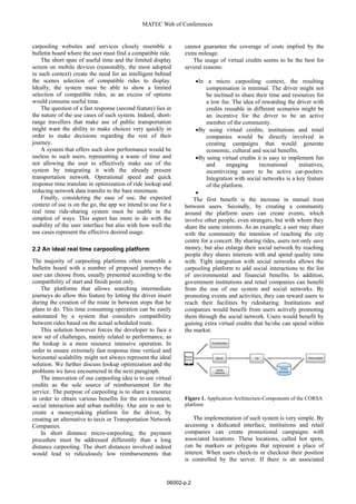
The system is composed of three main components
(see fig 1): a mobile frontend, a server backend with real
time bidirectional communication capabilities and a path
management system accessed through an API.
The app and the real time server communicate
through web sockets, while uses http protocol to calls the
path management API. In both cases, data is transferred
using JSON format.
A common problem in developing mobile apps that
require heavy interaction with a server is to establish
whether first developing the app and then the server or
conversely developing both of them side by side. What
emerged quickly was that usability was so important that
use cases would need to be tested for usability constraints
on a device or emulator. Graphical mockups did not aid
the purpose, since the lack of navigation structures in
mobile apps is substituted by gestures. Because of all of
this, we decided to use a web application as a mockup.
To compensate the absence of the API we created
static JSON files to inject data into the app. At the end a
testing stage where we evaluated usability of the UI and
use cases, the static JSON files actually described what
data the path management API had to provide and its
structure. With a well-defined structure, we were able to
concentrate on algorithms and query optimization during
the API implementation stage.
All details about (1) the mobile application that has
been developed, (2) the management of paths and (3)
server and application data can be found in [8].
4 Final remarks
In this paper we introduced CORSA, an open source
solution for a real time ride sharing (RTRS) with high
accessibility, high usability, and effectiveness and
efficiency in finding a riding solution for users. The
challenges a RTRS platform should cope with was also
discussed, from both a functional and a technical point of
view; the overall architecture was also outlined.
Future issues to be investigated are (1) how the use of
social network can improve the proposed carpooling
service (2) to discover and exploit hidden relationships,
for instance communities among users sharing trips and
(3) to gather data on users and rides for further analysis.
Acknowledgements
This work was developed under the projecty ”S.R.S. -
Progetto di formazione integrato SINERGREEN (Smart
Intelligent Energy Green), RES-NOVAE, SEM”
supported by MIUR (Minister of Education, University
and Research).
References
1. Fagin, R. & Williams, J.H., A fair carpool
scheduling algorithm. IBM J Res Dev, 27(2), pp.
133–139, 1983.
2. Teal, R.F., Carpooling: Who, how and why.
Transportation Research Part A: General, 21(3), pp.
203 – 214, 1987.
3. Golbeck, J., The dynamics of web-based social
networks: Membership, relationships, and change.
First Monday, 12(11), 2007.
4. Carchiolo, V., Longheu, A., Malgeri, M. & Mangioni,
G., Trust assessment: A personalized, distributed,
and secure approach. Concurr Comput : Pract Exper,
24(6), pp. 605–617, 2012.
5. Carchiolo, V., Longheu, A., Malgeri, M. & Mangioni,
G., Users attachment in trust networks: Reputation vs.
effort. IJBIC, 5(4), pp. 199–209, 2013.
6. Carchiolo, V., Longheu, A., Malgeri, M. & Mangioni,
G., Search for overlapped communities by parallel
genetic algorithms. IJCSIS, 6, no.2, 2009.
7. Leskovec, J., Adamic, L.A. & Huberman, B.A., The
dynamics of viral mar-keting. ACM Trans Web, 1(1),
2007.
8. [Loria, M. & Bonarrigo, S., Rtrs: a social oriented
proposal. Technical report, DIEEI - Universita’ di
Catania, 2014.
06002-p.3
ICAME 2015