A full teaching learning slides on climate of Pakistan aimed for the support of 0 level students and teachers in the subject Environment of Pakistan 2059/2
The document provides information on the topography and physical geography of Pakistan. It discusses the following key points:
- Pakistan has varied topography including plateaus, mountains, deserts and coastal areas. The largest plateau is the Balochistan plateau, located in southwestern Pakistan.
- The two major plateaus discussed are the Balochistan plateau and Potwar plateau. The Balochistan plateau covers most of Balochistan province, while the Potwar plateau is located in northern Punjab province.
- The plateaus have different climates, soils and agricultural practices based on their terrain and environment. People have adapted livelihoods like herding and rain-fed farming to the physical geography of the plateaus
South Asia's physical landscape has been shaped by its geography. The Himalayan and Hindu Kush mountains form barriers to the north, while the Arabian Sea, Bay of Bengal, and Indian Ocean surround it on three sides. The region is divided into three major regions - the northern mountains, northern plains, and Deccan plateau. The Himalayas and Hindu Kush mountains influence South Asia's climate and contain many of the region's major river systems like the Indus and Ganges.
Digital 2021 Ireland (January 2021) v01DataReportal
All the data, statistics, and trends you need to make sense of digital in Ireland in 2021. Includes the latest reported numbers for internet users, social media users, and mobile connections in Ireland, as well as key indicators of ecommerce use. For more reports, including the latest global trends and individual data for more than 230 countries around the world, visit https://datareportal.com/
The document discusses different sources of rainfall in Pakistan, including monsoon winds, western depressions, convectional currents, relief rainfall, and tropical cyclones. It provides details on each source such as the timing and direction of monsoon winds, the path and rainfall amounts from western depressions, and how convectional currents and relief rainfall occur in different parts of Pakistan. Tropical cyclones are mentioned as occasionally originating in the Arabian Sea but rarely reaching Pakistan's coast.
Este documento presenta varias actividades relacionadas con la geografía física de España. Incluye términos clave del relieve español, un análisis de un mapa de unidades morfoestructurales, un perfil topográfico transversal de la península ibérica, y ejercicios para identificar sistemas montañosos, ríos, accidentes costeros y unidades del relieve en mapas de España.
Digital 2021 Georgia (January 2021) v01DataReportal
All the data, statistics, and trends you need to make sense of digital in Georgia in 2021. Includes the latest reported numbers for internet users, social media users, and mobile connections in Georgia, as well as key indicators of ecommerce use. For more reports, including the latest global trends and individual data for more than 230 countries around the world, visit https://datareportal.com/
Digital 2022 Central African Republic (February 2022) v01DataReportal
All the data, statistics, and trends you need to make sense of digital in the Central African Republic in 2022. Includes the latest reported numbers for internet users, social media users, and mobile connections in the Central African Republic, as well as key indicators of ecommerce use. For more reports, including the latest global trends and individual data for more than 230 countries around the world, visit https://datareportal.com/
Pakistan has four seasons and receives most of its rainfall during the summer monsoon season from June to September. The major sources of rainfall include monsoon winds, western depressions, convectional currents, and relief rainfall from mountains. Flooding often occurs when heavy monsoon rains cause rivers like the Indus to overflow their banks. Floods destroy crops, damage infrastructure, and spread disease. Actions are needed to reduce flooding such as building dams, planting more trees, and restricting construction on floodplains.
El documento proporciona información sobre el Sahara Occidental. Se encuentra ubicado en África, entre Mauritania y Marruecos, con un clima soleado pero frío. Sus principales riquezas naturales son el petróleo, los fosfatos y la pesca. La gastronomía local incluye platos como el cuscus, el arroz con carne y el mreifisa. La población viste prendas tradicionales como la darra y la malehfa. Parte de los habitantes viven en campamentos de refugiados en Argelia.
MapFish Print 3 : Printing maps like a bossCamptocamp
MapFish Print 3 is an updated version of the MapFish Print map printing library that features a plugin framework, web API, and improved YAML configuration. It allows printing maps and adding other elements like tables, charts, and multiple maps across pages from various data sources. The new version is designed with a pluggable architecture for extensibility while maintaining backwards compatibility.
El documento describe el proceso para realizar un comentario de un hidrograma. Primero se identifican los elementos del gráfico como el tipo de gráfico, la escala temporal y los datos numéricos. Luego se interpreta y analiza los datos identificando picos máximos y mínimos. Finalmente, se presentan conclusiones sobre el régimen del río, la zona geográfica y posibles aprovechamientos y regulación basados en el análisis.
Criterios corrección. examen de Geografía JUNIO 2022en Castilla la Mancha. Ev...Juan Martín Martín
Criterios de corrección del examen de Geografía de Selectividad (EvAU) Julio de 2022 en Castilla La Mancha.
Soluciones al examen.
Convocatoria Ordinaria. Examen especial como consecuencia de Covid-19
Examen resuelto de Geografía
conocer el examen de geografía de julio 2022 en:
http://blogdegeografiadejuan.blogspot.com/2022/07/examen-de-selectividad-geografia-julio.html
http://blogdegeografiadejuan.blogspot.com/2013/09/examenes-de-selectividad-de-geografia.html
15 la industria en españa el proceso de industrialización y sus hitos más rec...Miguel Romero Jurado
15 la industria en españa el proceso de industrialización y sus hitos más recientes.factores de la actividad industrial principales sectores industriales en la actualidad distribución geográfica de la industria
España tiene varios tipos de climas debido a su ubicación geográfica, orografía compleja y costas extensas. Los principales climas son el oceánico en el norte con lluvias regulares, el mediterráneo en el interior y sur con veranos secos e inviernos suaves, y el árido en el sureste con poca precipitación. Cada clima se define por sus patrones de temperatura y precipitación.
Este documento describe el clima y la vegetación de España. Explica que el clima de España está influenciado por factores geográficos como la latitud, altitud y proximidad al mar, así como por factores atmosféricos como las masas de aire y sistemas de presión. Identifica varios tipos de climas en España como el clima oceánico, mediterráneo, estepario y de montaña. También describe la diversa vegetación de España, incluyendo bosques, matorrales y especies vegetales propias del clima mediterr
The document provides information on the topography and physical features of northern mountains in Pakistan. It discusses the three main mountain ranges: the Karakoram, Himalaya, and Hindu Kush ranges. Key details include the high altitudes and glaciers of the Karakoram range, location and peaks of the Himalaya range, and rivers that flow from the Hindu Kush mountains. It also summarizes important valleys, passes, crops, and way of life in the northern mountain regions of Pakistan.
This document provides an overview of the geography of Asia. It begins with an introduction to Asia's size and diversity. It then describes Asia's major physical divisions, including the northern lowlands, central mountains, southern plateaus, great river valleys, and island groups. The document also discusses the key climate factors of Asia and how they contribute to its various climate regions and rainfall patterns. It concludes that Asia's diverse physical geography results in a wide variety of climates and landscapes across the continent.
Climate refers to the average weather conditions in an area over a long period of time, usually 30 years or more. It is influenced by temperature, air pressure, winds, humidity, cloudiness, and precipitation. Weather describes the short term state of the atmosphere at a specific time and place. Climate is determined by a chain of elements including temperature, winds, humidity, cloud formation, and different types of precipitation which are influenced by factors like air pressure changes, vertical and horizontal air movement, topography, and proximity to bodies of water and the equator. India's climate is considered a monsoon climate which is marked by a seasonal reversal of wind direction.
Esta presentación no es mía, es decir, no la he realizado yo, está sacada de las redes, pero hace bastante tiempo, con lo cual no sé cuál es la fuente original.
Este documento proporciona información sobre el clima y los seres vivos. Explica que la atmósfera está compuesta de varias capas como la troposfera y la estratosfera. Describe los elementos del clima como la temperatura, las precipitaciones, la presión atmosférica y el viento. También diferencia entre tiempo atmosférico y clima, y explica cómo estos elementos afectan los diferentes climas en la Tierra.
A full teaching learning slides on climate of Pakistan aimed for the support of 0 level students and teachers in the subject Environment of Pakistan 2059/2
This document summarizes the climate of Pakistan. It discusses various climatic zones based on topography, including highland, lowland, coastal, and arid climates. It also describes the four main climatic elements - air pressure, winds, temperature, and rainfall. Different climatic regions experience different weather patterns due to variations in these elements. For example, northern areas receive monsoon rains while coastal areas experience sea breezes that bring moisture. The document also covers climate-related phenomena like droughts and floods that impact Pakistan.
This document discusses the weather and climate of India. It begins by defining weather and climate, then describes the six major controls of climate: latitude, altitude, pressure/wind systems, distance from the sea, ocean currents, and relief features. It explains how these factors influence India's climate, which largely depends on the southwest monsoon winds that arrive between June and September, bringing heavy rainfall. The document outlines India's four main seasons and their characteristics.
Weather refers to current atmospheric conditions like temperature, wind, and precipitation, while climate describes average weather patterns over 30+ years. India's climate is influenced by its latitude near the Tropic of Cancer, the Himalayan mountains, ocean currents, and monsoon winds. The monsoon season from June to September brings most of India's annual rainfall, though it can vary significantly between wet and dry periods. India experiences four main seasons - a cold winter, hot summer, advancing monsoon rains, and retreating monsoon transition.
Weather refers to current atmospheric conditions like temperature, wind, and precipitation, while climate describes average weather patterns over 30+ years. India's climate is influenced by its location near the equator, the Himalayan mountains, ocean currents, and monsoon winds. The four main seasons in India are winter, summer, the rainy season brought by advancing monsoons, and a transition season as the monsoons retreat.
Weather refers to current atmospheric conditions like temperature, wind, and precipitation, while climate describes average weather conditions over a long period of time. India's climate is influenced by its location near the equator, the Himalayan mountains, ocean currents, and the seasonal southwest monsoon winds which bring heavy rainfall during summer. The four main seasons in India are the dry, cool winter; hot, dry summer; wet, rainy monsoon season; and the transition retreating monsoon period in fall.
The document discusses the climate and weather patterns of Pakistan. It describes four main seasons in Pakistan - winter, early summer, late summer, and post-monsoon. Rainfall in Pakistan comes from monsoon winds, western depressions, convectional currents, relief rainfall, and tropical cyclones. Pakistan has several climatic zones including the highland zone with cold winters and mild summers, the arid zone with hot and dry conditions, the lowland zone with hot summers and cool winters, and the coastal zone with moderate temperatures influenced by the sea. Factors like latitude, altitude, and proximity to the sea or desert affect temperatures across Pakistan. Flooding sometimes occurs when excessive monsoon rains cause rivers to
India has a monsoon type climate characterized by distinct seasonal patterns. The climate is influenced by factors like latitude, altitude, pressure systems, distance from the sea, and ocean currents. The monsoon winds bring heavy rainfall during summer but their arrival and retreat is often irregular, causing uncertainties in agricultural activities. The monsoon binds the country together by providing water for farming across most regions, though some areas receive heavy rainfall while others experience drought.
The document discusses climate and weather patterns in Pakistan. It covers factors that influence climate such as altitude, distance from the sea, latitude, ocean currents, prevailing winds. It then discusses temperature variations and records in Pakistan. It describes monsoon winds and rainfall, western depressions, convectional and relief rainfall. It also covers air pressure, winds, and tropical cyclones that can impact Pakistan's climate.
Class IX - Climate
This lesson throws light upon the details of lesson climate, of CBSE board.
This ppt can be used to revise the lesson in a better manner.
it has details on coriolis force, ferrel's law, monsoon winds
This document provides an overview of climate and seasons in India. It discusses regional variations in temperature and precipitation across India. The main factors that influence India's climate are also summarized, including latitude, altitude, pressure systems, ocean currents, and relief features. The document then describes the mechanism and timing of the Indian monsoon system and its onset and withdrawal throughout the country. The four main seasons in India - cold weather, hot weather, advancing monsoon, and retreating monsoon - are briefly outlined. The document concludes by noting how the monsoon acts as a unifying factor across India.
The document discusses India's climate and monsoon patterns. It notes that India experiences both tropical and subtropical climates due to its latitude. The monsoon is caused by differential heating of land and sea surfaces, resulting in reversal of wind patterns between summer and winter. In summer, moist southwestern winds bring heavy rainfall as the Inter-Tropical Convergence Zone shifts northward. Various factors like pressure systems, jet streams, and elevation differences result in regional rainfall variations within India.
An informative and connective presentation to class 9 Geography chapter climate. Covers all topics and gives adequate information about it. Easy to understand.
The document provides information about India's climate and monsoon system. It discusses several key points:
1) India's climate is dominated by the monsoon system which brings seasonal reversal of winds and heavy rainfall from June to September.
2) Major factors influencing India's climate include latitude, altitude, pressure systems and winds, distance from the sea, and ocean currents.
3) The monsoon is caused by differential heating of land and sea which creates low pressure over India and high pressure over the oceans, drawing in the moisture-laden southwest winds during summer.
4) India experiences distinct seasonal patterns with a hot summer season, rainy monsoon season, and cooler winter season with some regional variations.
Factors Affecting the Climate Grade 9 Quarter 3 Week 4OskarOida
1. The document discusses various factors that affect climate, including latitude, altitude, topography, ocean currents, wind systems, and the Earth's movement.
2. Specific wind systems that influence the Philippines' climate are discussed, such as the northeast and southwest monsoons.
3. Different factors like latitude, altitude, proximity to oceans, and landforms cause areas to experience varying weather patterns and temperatures.
This document provides an overview of India's climate and weather patterns. It discusses that India experiences a tropical monsoon climate characterized by seasonal reversal of winds. The key factors influencing India's climate are discussed as latitude, altitude, pressure systems, distance from the sea, ocean currents and relief features. The seasonal patterns of winter, summer and monsoon seasons are described along with climate variations across different regions of India and mechanisms driving the monsoon system.
The document discusses the Indian monsoon system. It defines monsoon as seasonal reversing winds accompanied by changes in precipitation. It notes that India's climate is strongly influenced by the monsoon winds. The monsoon seasons include the advancing monsoon from June to September, which brings heavy rainfall, and the retreating monsoon from October to November, marked by clearer skies and rising temperatures. Rainfall distribution across India is uneven, with higher amounts on the western coast and lower in parts of Rajasthan.
This document summarizes the climate of India, focusing on the tropical monsoon climate and seasonal variations. It discusses key factors like the Indian monsoon winds which are influenced by differential heating/cooling of land and sea and the movement of pressure systems. India experiences a hot summer season from March to May with high temperatures, a rainy season from June to September brought by the southwest monsoons, and a mild winter season from November to February in the north with variable winds and occasional rainfall. The climate varies significantly by region due to factors like latitude, altitude, proximity to oceans, and monsoon patterns.
There are different learning styles that are best fitted for any individual's intelligence . It is best to style your learning that best befits you." learn how to learn"
Teaching is a science of art. Teaching is most effective when it is fun and when it matches the learners ambitions and abilities . Learn more of it.............
Nurses play a critical role as health educators to help patients understand their conditions and make informed health decisions. Effective communication is essential for nurses to develop relationships with patients, understand their needs and concerns, and ensure treatment plans are followed. Some key aspects of effective communication include active listening, speaking clearly, maintaining appropriate verbal and nonverbal communication, being culturally aware, and overcoming potential barriers like differences in language, stress, or disabilities. Proper documentation is also important for communicating treatment plans and progress to the entire care team.
As time changes and new inventions are introduced , the life pattern and practices for nurture and parenting also makes new demand . It is essential to open up to new ideas and understand the changing parenting trends in demand for effective children development.
These are discussion slides on the strategies that teachers can adopt for making education and classroom experience interactive and learning friendly. It is essential to understand that differences have to be acknowledged and be addressed. Because that is what makes the learning effective. Diversity is strength - use it for making learning to happen!
The document discusses modern parenting challenges and provides guidance on grooming care. It notes that family structures have changed from extended to nuclear and parenting tools now include influences from social media, technology, and peer groups. Providing good grooming care requires having compassionate relationships with children, reflecting knowledge, demonstrating rules and behaviors, and acknowledging new social challenges. Identifying social partners can help with the challenges of lack of time, teaching moral values, work-life imbalance, lack of trust, nutrition, and technology overuse. Being a mother is a complex role that impacts children daily through modeling behavior and directing the family role play.
The fishing industry in Pakistan contributes to GDP and foreign exchange earnings, including marine fishing off the coasts of Sindh and Makran as well as inland fishing in lakes and fish farms. While fishing provides food and income, overfishing and pollution pose threats that sustainable practices could help address by increasing exports and skills while preserving the resource.
Pakistan has large reserves of minerals including coal, gold, copper, and iron ore. Minerals are formed through the cooling and crystallization of magma underground over hundreds of years. Mining involves extracting rocks and minerals from the earth through surface or underground methods. Surface mining includes open-cast mining while underground mining uses adit or shaft mining. Mining is important for Pakistan's economy, contributing to industries like construction, agriculture, and electricity generation as well as employment and trade. However, challenges include lack of investment, technical skills, and environmental impacts such as deforestation, pollution, and damage to landscapes.
Guide for developing answer script for 0 level students
1. Response should be meaningful, less wordy and more content. The rationale should be clearly stated and the content be well connected.
2. Students may dissect the above response and apply the marking scheme for enhancing understanding and requirement of an answer script.
The document discusses the Indus Water Treaty signed in 1960 between India and Pakistan to share the water from the Indus River and its tributaries. It summarizes the key terms of the treaty, including that Western rivers like the Indus, Jhelum, and Chenab were allocated to Pakistan, while Eastern rivers like the Sutlej, Beas, and Ravi were allocated to India. It also discusses subsequent disputes between the countries over construction of hydroelectric projects on shared rivers and the need to periodically review and modernize the treaty terms.
Floods in Pakistan : The slides discuss the types, causes , effects and management of floods at both the preventive level as well as mitigation and response . The post floods benefits are listed
Teaching & learning slides for Western Mountains of Pakistan
Aimed to address the learning needs of 0 level Cambridge students for Environment of Pakistan 2059/2
Teaching & learning slides for Northern Mountains of Pakistan
Aimed to address the learning needs of 0 level Cambridge students for Environment of Pakistan 2059/2
The slides discuss six types of renewable energy ( hydro, solar wind, Geo, tidal and biomass) , explain the method used for producing electricity in each type followed by the advantages and disadvantages of each. Lastly it explores the potential of renewable energy in Pakistan
The document discusses various modes of transportation in Pakistan. It describes land transportation including traditional methods like bullock carts as well as the modern railway and road systems. It outlines the railway network and gauges, as well as challenges like outdated infrastructure. Road transportation is also analyzed, comparing highways, motorways and their advantages like flexibility but also disadvantages like traffic congestion. Air, water and pipeline transportation are briefly covered as well. The document provides a comprehensive overview of Pakistan's transportation systems, the infrastructure that supports different modes, and their benefits and limitations.
The simplified electron and muon model, Oscillating Spacetime: The Foundation...RitikBhardwaj56
Discover the Simplified Electron and Muon Model: A New Wave-Based Approach to Understanding Particles delves into a groundbreaking theory that presents electrons and muons as rotating soliton waves within oscillating spacetime. Geared towards students, researchers, and science buffs, this book breaks down complex ideas into simple explanations. It covers topics such as electron waves, temporal dynamics, and the implications of this model on particle physics. With clear illustrations and easy-to-follow explanations, readers will gain a new outlook on the universe's fundamental nature.
How to Fix the Import Error in the Odoo 17Celine George
An import error occurs when a program fails to import a module or library, disrupting its execution. In languages like Python, this issue arises when the specified module cannot be found or accessed, hindering the program's functionality. Resolving import errors is crucial for maintaining smooth software operation and uninterrupted development processes.
Executive Directors Chat Leveraging AI for Diversity, Equity, and InclusionTechSoup
Let’s explore the intersection of technology and equity in the final session of our DEI series. Discover how AI tools, like ChatGPT, can be used to support and enhance your nonprofit's DEI initiatives. Participants will gain insights into practical AI applications and get tips for leveraging technology to advance their DEI goals.
This presentation was provided by Steph Pollock of The American Psychological Association’s Journals Program, and Damita Snow, of The American Society of Civil Engineers (ASCE), for the initial session of NISO's 2024 Training Series "DEIA in the Scholarly Landscape." Session One: 'Setting Expectations: a DEIA Primer,' was held June 6, 2024.
Exploiting Artificial Intelligence for Empowering Researchers and Faculty, In...Dr. Vinod Kumar Kanvaria
Exploiting Artificial Intelligence for Empowering Researchers and Faculty,
International FDP on Fundamentals of Research in Social Sciences
at Integral University, Lucknow, 06.06.2024
By Dr. Vinod Kumar Kanvaria
हिंदी वर्णमाला पीपीटी, hindi alphabet PPT presentation, hindi varnamala PPT, Hindi Varnamala pdf, हिंदी स्वर, हिंदी व्यंजन, sikhiye hindi varnmala, dr. mulla adam ali, hindi language and literature, hindi alphabet with drawing, hindi alphabet pdf, hindi varnamala for childrens, hindi language, hindi varnamala practice for kids, https://www.drmullaadamali.com
How to Manage Your Lost Opportunities in Odoo 17 CRMCeline George
Odoo 17 CRM allows us to track why we lose sales opportunities with "Lost Reasons." This helps analyze our sales process and identify areas for improvement. Here's how to configure lost reasons in Odoo 17 CRM
How to Add Chatter in the odoo 17 ERP ModuleCeline George
In Odoo, the chatter is like a chat tool that helps you work together on records. You can leave notes and track things, making it easier to talk with your team and partners. Inside chatter, all communication history, activity, and changes will be displayed.
How to Setup Warehouse & Location in Odoo 17 InventoryCeline George
In this slide, we'll explore how to set up warehouses and locations in Odoo 17 Inventory. This will help us manage our stock effectively, track inventory levels, and streamline warehouse operations.
Strategies for Effective Upskilling is a presentation by Chinwendu Peace in a Your Skill Boost Masterclass organisation by the Excellence Foundation for South Sudan on 08th and 09th June 2024 from 1 PM to 3 PM on each day.
2. WEATHER
Weather is an atmospheric condition that is
constantly changing. It is not predictable nor will it
repeat itself in the same sequence
Weather does not repeat itself in the same manner
like the climate does, e.g. seasons are climatic
conditions; therefore summer, winter, autumn will
come and repeat itself around same time and within
same conditions.
2 Asma Akbar Ali
5. CLIMATE
Asma Akbar Ali5
Climate is the generalised condition that will follow
a specific sequence (It will repeat itself and
maintain the average weather for long periods like
the whole summer will be hot with varying
atmospheric conditions just like whole winter will
be cold weather etc
Climate takes hundreds, thousands, even millions
of years to change e.g. climate change happening
..............
We are witnessing changes as specific weather
conditions like raised temperature, harsh winds,
limited rain etc. till one day it will manifest as the
climate!
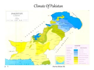
6. CLIMATIC ZONES
There are four diverse climatic zones in Pakistan
due to the varying topographical features
The Climatic Zones are
1. Highland Zone Climate
2. Lowland Zone Climate
3. Coastal Zone Climate
4. Arid Zone Climate
6 Asma Akbar Ali
8. CLIMATIC ZONE LOCATIONS
Highland
Zone
Low Land Zone Coastal Zone Arid Zone
North , North
Western
mountains and
Western
Mountains
The whole Indus
plain - Both
Upper and
Lower
Whole
Coastal line
Makran Coast
Karachi Coast
South eastern
deserts and
South western
parts of
Balochistan
8 Asma Akbar Ali
CLIMATIC ZONES – LOCATION
12. WORKSHEET ON SEASONS – Refer Fig 2.8 page 31
Fill in the information – 20 marks
Asma Akbar Ali12
Seasons Effect seen on Climatic
Zones
Why ( refer to the factors
affecting temperature
Winter
Mid Dec - March
Summer
April – June
Monsoon
July - September
Post Monsoon
Oct –Mid Dec
13. FACTORS AFFECTING TEMPERATURE
1. Latitudinal Effect
2. Continental Effect
3. Altitude and Temperature
4. Cloud Cover and temperature
5. Latitude and angle of sun
13 Asma Akbar Ali
17. Hydrological/ Water Cycle
Asma Akbar Ali17
Evaporation
Vapour & Clouds
Transport
Condensation
Precipitation
What happens then
1. Run off Absorption river flow
2. Run off infiltration percolation
Groundwater
18. Sources of Rainfall in Pakistan
Asma Akbar Ali18
1. Monsoon Rains
2. Western Depressions
3. Convectional Currents causing Thunder
storms
4. Relief rainfall
5. Tropical Cyclones
19. Monsoon RAINS or SEASONAL RAINS
Summer are South west winds
Winter are North east winds
19 Asma Akbar Ali
20. MONSOON RAINFALL
June to September
Monsoon winds develop when the sun heats up the
tropical continents much faster then the oceans
around . Warm air rising creates low pressure
which attracts cool moist air from the sea therefore
the rain bearing winds come inland and bring rain
Starts from the Bay of Bengal crosses Bangladesh
and north India entering Northern east Pakistan
Weak winds blow from Arabian sea but at times
they merge making an over active monsoon in
Karachi
20 Asma Akbar Ali
21. MONSOON BENEFITS THE EAST
Asma Akbar Ali21
The winds start to blow
from June by July it
reaches Pakistan and
enter Northern part of
Pakistan
Punjab Majority
rainfall and lowering
winds come to Sindh in
the eastern part of
Pakistan
23. IMPORTANCE OF MONSOON RAIN
Asma Akbar Ali23
1. The rainy season, or monsoon season, is the time of
year when most of a region's average annual rainfall
occurs.
2. Summer monsoon season in Pakistan is of
great importance for its agricultural, economic and
social purposes.
3. These rains are not only used for water needs of
plants in agricultural sector but also to kill the
insects by physical beating.
24. WESTERN DEPRESSIONS
24 Asma Akbar Ali
Journey begins from the Mediterranean sea to
Afghanistan and Iran
Enters North Western part of Pakistan such as
Peshawar and by the time it reaches south
western parts – Baluchistan they are drained
off the moisture
26. CONVECTIONAL CURRENTS - THUNDER STORMS
Extreme heat in the summer will make the hot
moisture air to rise ( May & June)
Mainly in the highland zone like northern
Punjab and KPK
Other then the regular rains
Usually manifest itself as thunderstorm –
strong winds and dust
Southern Pakistan is deprived of convectional
rainfall due to the temperature inversion layer
26 Asma Akbar Ali
27. INVERSION LAYER
Asma Akbar Ali27
Inability of the water vapor to condense due to the
warm winds that do not allow the vapor to move up
29. RELIEF RAIN
Asma Akbar Ali29
Relief Rainfall is when the wind is forced to cool as it is getting
higher because it is hitting high mountainous areas and then
as it starts to lower again.
This is called relief rainfall because the cloud is being relieved
of the weight of the vapour
30. TROPICAL CYCLONES
1. Few hours of heavy rain and destructive
winds to the coastal areas .
2. They originate from Arabian sea
3. Does not happen often or regularly but it can
happen once in a few years
4. This type of rain can happen at anytime near
the coastland
30 Asma Akbar Ali
31. Difference Between
Thunder storms & Tropical Cyclones
Asma Akbar Ali31
Thunder storms are strong charged winds that blow
aggressively . They contain dust and other
atmospheric particles. They can occur during the early
summer pre-monsoon time
Whereas
Tropical cyclones bring few hours of heavy rains and
destructive winds to the coastal areas . They originate
from Arabian sea frequently but very rarely able to
reach the coast . These cyclones every few years and
cannot be easily predicted
33. EFFECTIVENESS OF RAINFALL
1. The two major rains of Pakistan are the Monsoon and
The Western depressions.
2. These rains are not always reliable they differ in
amount, timing and distribution
3. This is why not always reliable for agriculture
especially when the hot summers from June to
September leading to higher degree of evapo-
transpiration
4. Heavy showers is not very affective for agriculture
because it has aggressive run –off
33 Asma Akbar Ali
34. Factors affecting the differences in Climate
Asma Akbar Ali34
1. High temperature due to the Latitudinal effect
2. Relief rain fall in high altitude areas like the north and
northwestern mountains
3. Monsoon winds /Summer rains to Indus plains and northern
Pakistan
4. Maritime influence at the coastal areas – low temperature and
high humidity because the coastal winds keep the temperature
comparatively low in summer and high in winter
5. Western Depressions benefit the western part during winter
Also known as the winter rains
6. Convectional currents are other than regular rains
7. Convectional currents do not happen in southern Pakistan due
to the Inversion layer
8. Central Pakistan is warmer due to the continental effect
9. Tropical cyclone bring destructive winds from the Arabian sea
36. PRACTICE QUESTION # 2
Asma Akbar Ali36
1. Name the areas of
High rainfall A & B (2)
2. Name the body of
water that is the
source of moisture for
each of the monsoon
winds X and Y (2)