chung_AGU_poster_2015_updated
•
0 likes•176 views
This document summarizes a hierarchical object-based image analysis approach used to classify sub-meter multispectral imagery in Tanzania. It describes the workflow, which includes image segmentation, feature selection, classification using decision trees and random forests, and accuracy assessment. Results showed overall accuracy above 85% for both algorithms, demonstrating the effectiveness of the object-based approach for discriminating land cover classes at a detailed scale. The study was funded by Conservation International and performed using tools like eCognition and WorldView2 satellite imagery.
Report
Share
Report
Share
Download to read offline
Recommended
Nat poster
This document summarizes a study that investigated using deep learning to classify x-ray images of quarantine items. Researchers collected x-ray image data of 21 quarantine item classes and used it to train a convolutional neural network model. The model achieved an overall accuracy of 25.5% on the test set, with higher accuracy for some classes like banana and dracaena, and lower accuracy for others like tree ear mushroom and asparagus that had poorer visibility in x-rays. While the overall accuracy was low, the confusion matrix showed the model could differentiate between classes to some degree. Improving the model would require more image data per scan type to better generalize object shapes and labels.
MRI Tissue Segmentation basics
gives basic knowledge about the methods, need and related work of bias field estimation and inhomogeneties.
FINAL_POSTER_SAFARA_USF_RESEARCH_SYMPOSIUM_2015
This study developed a method to measure the flexibility of electrospun fibers using electron microscopy images. The method involves using image processing software to trace fiber contours and measure the average angle and distance between coordinates. This allows calculating a persistence length, which quantifies flexibility. The method was applied first to poly(acrylic acid) fibers, then to polypeptide fibers. Over 1000 coordinates were traced and analyzed to determine persistence lengths. The goal was to develop a technique for characterizing the mechanical properties of electrospun fibers based on electron micrographs.
MRI Tissue Segmentation using MICO
From this presentation, you can know about an MRI Tissue Segmentation method called "Multiplicative Intrinsic Component Optimization(MICO)"
Skin Lesion Segmentation Using TDLS Algorithm and Pattern Identification
Abstract: The rapid growing rate of Melanoma makes researchers to study in depth about it. It is the most deadliest form of skin cancer. Due to the higher costs for dermatologists, images of skin lesion of the patient are taken and texture-based skin lesion segmentation algorithm is proposed. Different regions belonging to different textures are studied. Finally the image is classified as normal skin or lesion. Different model based pattern classification of the lesion is proposed. We mainly classify the whole pigmented lesion into three possible patterns: globular, reticular, and homogeneous.
A STUDY ON WEED DISCRIMINATION THROUGH WAVELET TRANSFORM, TEXTURE FEATURE EXT...
Texture based weed classification has played an important role in agricultural applications. In the recent years weed classification based on wavelet transform is an effective method. But the feature extraction is main issue for proper classification of weed species. In this paper, the issue of statistical and texture
classification based on wavelet transform has been analysed. The efficient texture feature extraction
methods are developed for weed discrimination. Three group feature vector can be constructed by the mean
and standard deviation of the wavelet statistical features (WSF), Texture feature as Contrast, Cluster
Shade, Cluster Prominence and Local Homogeneity (WCSPH) and Energy, Correlation, Cluster Shade,
Cluster Prominence and Entropy features (WECSPE) which are derived from the sub-bands of the wavelet
decomposition and are used for classification. Experimental results show that Rbio33 Wavelet with
WECSPE texture feature obtaining high degree of success rate in classification.
Project presentation - Capstone
The document discusses using a convolutional neural network (CNN) to classify chest x-ray images as having a diagnosable condition or not. It describes preprocessing the NIH chest x-ray dataset, performing a t-test to determine mean grayscale values differ between normal and abnormal images, developing and training a CNN model, and evaluating the model's performance. The CNN model achieved 63.13% validation accuracy, outperforming pre-trained ResNet50 and MobileNet models fine-tuned on the task. Future work involves further tuning and evaluating the CNN for classifying specific disease types.
Image processing to identify foliar infection
Most important and basic recognition requirement for measuring percentage of Leaf Infection was expressed by “Stoyer’s experiment to determine Foliar Infections”. Other than this tedious and destructive method, a new and simple method for plant leaf infection measurement using image processing technique is provided in this research work. Leaves with different shape and size of same plant were selected for study. Conventional Experiments were performed to test the performance of the estimating system by comparing the estimated leaf infected area. The ranges of relative errors of estimation were analyzed for better future of research and development in this area. The results illuminated more accurate of the estimating leaf infected area. So it can be concluded that the method developed in this study obtained the sufficient accuracy for the possible non-destructive leaf Infection area measurement.
Comparison of Feature selection methods for diagnosis of cervical cancer usin...
Even though a great attention has been given on the cervical cancer diagnosis, it is a tuff task to observe the
pap smear slide through microscope. Image Processing and Machine learning techniques helps the pathologist
to take proper decision. In this paper, we presented the diagnosis method using cervical cell image which is
obtained by Pap smear test. Image segmentation performed by multi-thresholding method and texture and shape
features are extracted related to cervical cancer. Feature selection is achieved using Mutual Information(MI),
Sequential Forward Search (SFS), Sequential Floating Forward Search (SFFS) and Random Subset Feature
Selection(RSFS) methods.
IRJET- Sugarcane Leaf Disease Detection
This document proposes a system to detect diseases in sugarcane leaves early using image processing techniques. It uses a hidden Markov model for image segmentation and anisotropic diffusion to remove noise from images without blurring edges. A convolutional neural network is then used for disease classification. The system allows users to either select sample leaf images showing symptoms or capture images using a mobile device. It aims to help farmers identify diseases accurately to help minimize crop losses. The proposed system can detect diseases with 75% accuracy.
Determination ofRadiological Quality Parameters Using Optical Densitometer an...
This study determined radiological quality parameters using an optical densitometer and simple fabricated equipment. A wooden step wedge and metal pin were exposed to x-rays and their optical densities were measured. The results showed that simple fabricated equipment can determine parameters like dose, beam alignment, peak kilovoltage and tube current consistency without specialized quality control equipment. Optical density was directly proportional to factors like kilovoltage, tube charge and dose. Beam alignment was within acceptable limits. Therefore, simple fabricated devices can be used to establish quality protocols and monitor parameters in areas lacking quality control testing equipment.
On Predicting and Analyzing Breast Cancer using Data Mining Approach
Breast Cancer is one of the crucial and burning diseases that has invaded women. Predicting breast cancer manually takes a lot of time and it is difficult for the physician to classification. So, detecting cancer through various automatic diagnostic techniques is very necessary. Data mining is the process of running powerful classification techniques that extract useful information from data. The uses and potentials of these techniques have found its scope in medical data. Classification techniques tend to simplify the prediction segment.
Detection of skin diasease using curvlets
IJRET : International Journal of Research in Engineering and Technology is an international peer reviewed, online journal published by eSAT Publishing House for the enhancement of research in various disciplines of Engineering and Technology. The aim and scope of the journal is to provide an academic medium and an important reference for the advancement and dissemination of research results that support high-level learning, teaching and research in the fields of Engineering and Technology. We bring together Scientists, Academician, Field Engineers, Scholars and Students of related fields of Engineering and Technology.
A01110107
This document presents a method for detecting cancer in Pap smear cytological images using bag of texture features. The method involves segmenting the nucleus region from the images, extracting texture features from blocks within the nucleus region, clustering the features to build a visual dictionary, and representing each image as a histogram of visual words present. The histograms are then used to retrieve similar images from a database using histogram intersection as the distance measure. Experiments were conducted using different block sizes and number of clusters, achieving up to 90% accuracy in identifying cancerous versus normal cells.
Multimodal Medical Image Fusion Based On SVD
Image fusion is a promising process in the field of medical image processing, the idea behind is to
improve the content of medical image by combining two or more multimodal medical images. In this paper a
novel fusion framework based on singular value decomposition - based image fusion algorithm is proposed.
SVD is an image adaptive transform, it transforms the matrix of the given image into product USVT
, which
allows to refactor a digital image into three matrices called tensors. The proposed algorithm picks out
informative image patches of source images to constitute the fused image by processing the divided subtensors
rather than the whole tensor and a novel sigmoid-function-like coefficient-combining scheme is applied to
construct the fused result. Experimental results show that the proposed algorithm is an alternative image fusion
approach.
Dz33758761
This document reviews research on classifying crops from remotely sensed images. It discusses how multispectral and hyperspectral imagery have been used with both supervised and unsupervised classification techniques. Multispectral imagery provides good information for overall vegetation mapping but has limitations differentiating similar crops. Hyperspectral imagery can help overcome these limitations by identifying fine spectral differences. The document also discusses how microwave remote sensing, which is unaffected by clouds, can complement optical imagery by improving classification accuracy when data is fused. Overall, the review finds that remote sensing is useful for crop monitoring but challenges remain in identifying multiple crop types and differentiating similar crops.
Ghaziabad, India - Early Detection of Various Types of Skin Cancer Using Deep...
This presentation discusses using convolutional neural networks (CNNs) for intelligent skin cancer detection. CNNs can help address issues like limited doctor availability in rural areas and the high cost of cancer detection. Research shows CNNs can achieve 91% accurate cancer diagnosis compared to 79% for experienced physicians. The presentation then explains how CNNs work, discussing concepts like convolutional layers, pooling layers, activation functions, and transfer learning. It describes applying a CNN model trained on ImageNet to a skin cancer dataset in order to recognize 3 common cancer types. The goal is developing an automatic early-stage cancer detection system using CNNs and cloud computing to reduce human effort and costs while improving accuracy.
Breast cancer classification
This document proposes a method for classifying breast cancer cells using unsupervised linear transformation (PCA) along with cosine similarity. It involves the following steps: (1) applying PCA to select robust features from a breast cancer dataset, (2) projecting the data into a lower dimensional space using the selected features, and (3) classifying the cells as normal, benign, or malignant using cosine similarity in the reduced dimensional space. Experiments show the accuracy increases from 78.9% without PCA to 99.12% when using the proposed PCA-Cosine similarity method, demonstrating its effectiveness for breast cancer classification.
Brain tissue segmentation from MR images
This presentation was made for an engineering technical seminar in Biomedical engineering branch.
The presentation consist of working of MRI and method for segmenting the brain tissue..
The content was taken from various papers which are given as references at the end of ppt.
Spie, feb 2016, san diego poster
The poster was presented at the SPIE Conference held at San Diego in February, 2016. To stratify low-risk patients of Oral Cavity Cancer for recurrence, this work hypothesized the quantification of 3D models from serial histology.
Genetic Algorithm based Analysis of Rigid and Non Rigid Medical Images
This document discusses using a genetic algorithm to analyze and segment overlapping medical images, specifically chromosome images. It begins with an abstract describing how genetic algorithms and image segmentation can be used to identify chromosomal abnormalities by segmenting overlapping chromosome structures. It then provides background on chromosomes and genetic algorithms. The proposed method uses genetic algorithms to optimize an energy function and segment overlapping regions in chromosome images by identifying contrast regions as the fitness function. Masks are created to determine overlapping zones and the cropped image helps identify overlapping regions. The document describes the various steps involved, including binary mapping, image enhancement, contour detection, segmentation of overlapping regions, and identification of overlapping regions using genetic algorithms.
Lamichhane_PosterFinal
This study developed a MATLAB program to automatically analyze confocal microscope images of ligament tissues and determine the fiber orientation and distribution. The program uses FFT to calculate the fiber distribution coefficient (kΘ) and preferred fiber angle (Θp) from the images. It was tested on manufactured patterns and shown to accurately determine kΘ and Θp values. The program is being converted into a user-friendly Java application to help researchers understand ligament structure-function relationships and aid treatment development for injured ligaments.
50120140506006
This document summarizes a research paper that proposes a system for classifying microcalcifications in digital mammograms using nonsubsampled contourlet transform (NSCT). The proposed system has three main steps: 1) it decomposes mammogram images into multiple subbands using NSCT, 2) it modifies the decomposed subband images, and 3) it reconstructs an enhanced image from the modified subbands for improved microcalcification classification. The input database used is the Mini-MIAS database. The results showed the reconstructed images were more effective for microcalcification classification compared to the original mammograms.
Segmentation and Classification of Skin Lesions Based on Texture Features
Skin cancer is the most common type of cancer and represents 50% all new cancers detected each year. The deadliest form of skin cancer is melanoma and its incidence has been rising at a rate of 3% per year. Due to the costs for dermatologists to monitor every patient, there is a need for an computerized system to evaluate a patient‘s risk of melanoma using images of their skin lesions captured using a standard digital camera. In Proposed method, a novel texture-based skin lesion segmentation algorithm is used and to classify the stages of skin cancer using probabilistic neural network. Probabilistic neural network will give better performance in this system to detect a lot of stages in skin lesion. To extract the characteristics from various skin lesions and its united features gives better classification with new approached probabilistic neural network. There are five different skin lesions commonly grouped as Actinic Keratosis (AK), Basal Cell Carcinoma (BCC), Melanocytic Nevus / Mole (ML), Squamous Cell Carcinoma (SCC), Seborrhoeic Keratosis (SK). The system will be used to classify the queried images automatically to decide the stages of abnormality. The lesion diagnosis system involves two stages of process such as training and classification. Feature selection is used in the classified framework that chooses the most relevant feature subsets at each node of the hierarchy. An automatic classifier will be used for classification based on learning with some training samples of each stage. The accuracy of the proposed neural scheme is higher in discriminating cancer and pre-malignant lesions from benign skin lesions, and it attains an total classification accuracy is high of skin lesions.
A study of region based segmentation methods for mammograms
Abstract Breast Cancer is one of the most common diseases that are found in women. The number of women getting affected by cancer is increasing year by year. Detecting cancer in the late stages, leads to very complicated surgeries and the chance of death is very high. Early detection of Breast Cancer helps in less complicated procedures and early recovery. Many tests have been found so as to detect cancer. Some of these tests are mammography; ultrasound etc.Mammography is a method that helps in early detection of Breast cancer. But finding the mass and its spread from a mammographic image is very difficult. Expert radiologists are needed for accurate reading of a mammogram. Researchers have been working for years for algorithms that help for easy detection and segmentation of breast masses. Feature extraction and classification have also been done extensively so that the studied cases can be compared to diagnose the new cases. Segmentation of cancerous mass regions from the breast tissues is a difficult process. Many algorithms have been proposed for this. Some of these algorithms are region growing, watershed segmentation, clustering etc. Region Growing Method is based on two major factors which is the seed point selection and then the stopping criteria. Watershed Segmentation on the other hand is based on the basic geographical concept of watersheds and catchment basins, and uses a technique called as flooding. A study of these two major region based methods such as Region Growing and Watershed Segmentation are compared and detailed in this paper. Keywords: Mammography, Mass Detection, Segmentation, Region growing, and Watershed Segmentation.
S S S A2009 Simulation Study Of Segmentation
The study evaluated different segmentation methods for classifying pores and solids in computed microtomography images of soil aggregates. Simulated soil aggregate images were generated with varying porosity and partial volume effects to test the methods in absence of ground truth data. The Indicator Kriging method produced segmented images most similar to the ground truths across all cases and preserved pore characteristics best, as measured by misclassification error and a region non-uniformity metric. The study recommends using the region non-uniformity criterion and Indicator Kriging method for segmenting soil aggregate images.
Importance of Mean Shift in Remote Sensing Segmentation
1) Mean shift is a non-parametric clustering technique that can segment remote sensing images into homogeneous regions without prior knowledge of the number of clusters or constraints on cluster shape.
2) The document presents a case study demonstrating mean shift can segment an image containing oil storage tanks into distinct regions faster than level set segmentation.
3) Mean shift is shown to be well-suited for remote sensing image segmentation tasks like forest mapping and land cover classification due to its ability to handle noise, gradients, and texture variations common in real-world images.
“Detecting Data Drift in Image Classification Neural Networks,” a Presentatio...
“Detecting Data Drift in Image Classification Neural Networks,” a Presentatio...Edge AI and Vision Alliance
1) The document proposes a novel statistical method to detect and estimate the magnitude of data drift in image classification neural networks. It considers various types of data drift including noise effects, weather effects, and camera degradation.
2) The method introduces a "threshold probability" for each class to determine the percentage of predictions above the threshold at different drift magnitudes. This allows estimating the drift magnitude based on the difference between expected and observed percentages.
3) Experimental results on MNIST digit classification show the method can accurately detect and estimate the magnitude of different types of data drift like Gaussian noise, Poisson noise, and Salt & Pepper noise. The proposed approach helps neural networks cope with data drifts during operation.Molinier - Feature Selection for Tree Species Identification in Very High res...
This document summarizes a study that used feature selection and classification methods to identify tree species in high-resolution satellite images. The researchers tested 35 features on over 1000 ground reference samples to rank their effectiveness for classification. They found that 6 spectral features performed best when used in a 5-nearest neighbor classifier, achieving over 80% accuracy for tree species identification. While species proportions were estimated accurately, stem numbers per species showed only moderate correlation with field data. Future work could explore more advanced classifiers, cross-validation, and improving stem number estimation.
An ensemble classification algorithm for hyperspectral images
Hyperspectral image analysis has been used for many purposes in environmental monitoring, remote
sensing, vegetation research and also for land cover classification. A hyperspectral image consists of many
layers in which each layer represents a specific wavelength. The layers stack on top of one another making
a cube-like image for entire spectrum. This work aims to classify the hyperspectral images and to produce
a thematic map accurately. Spatial information of hyperspectral images is collected by applying
morphological profile and local binary pattern. Support vector machine is an efficient classification
algorithm for classifying the hyperspectral images. Genetic algorithm is used to obtain the best feature
subjected for classification. Selected features are classified for obtaining the classes and to produce a
thematic map. Experiment is carried out with AVIRIS Indian Pines and ROSIS Pavia University. Proposed
method produces accuracy as 93% for Indian Pines and 92% for Pavia University.
More Related Content
What's hot
Comparison of Feature selection methods for diagnosis of cervical cancer usin...
Even though a great attention has been given on the cervical cancer diagnosis, it is a tuff task to observe the
pap smear slide through microscope. Image Processing and Machine learning techniques helps the pathologist
to take proper decision. In this paper, we presented the diagnosis method using cervical cell image which is
obtained by Pap smear test. Image segmentation performed by multi-thresholding method and texture and shape
features are extracted related to cervical cancer. Feature selection is achieved using Mutual Information(MI),
Sequential Forward Search (SFS), Sequential Floating Forward Search (SFFS) and Random Subset Feature
Selection(RSFS) methods.
IRJET- Sugarcane Leaf Disease Detection
This document proposes a system to detect diseases in sugarcane leaves early using image processing techniques. It uses a hidden Markov model for image segmentation and anisotropic diffusion to remove noise from images without blurring edges. A convolutional neural network is then used for disease classification. The system allows users to either select sample leaf images showing symptoms or capture images using a mobile device. It aims to help farmers identify diseases accurately to help minimize crop losses. The proposed system can detect diseases with 75% accuracy.
Determination ofRadiological Quality Parameters Using Optical Densitometer an...
This study determined radiological quality parameters using an optical densitometer and simple fabricated equipment. A wooden step wedge and metal pin were exposed to x-rays and their optical densities were measured. The results showed that simple fabricated equipment can determine parameters like dose, beam alignment, peak kilovoltage and tube current consistency without specialized quality control equipment. Optical density was directly proportional to factors like kilovoltage, tube charge and dose. Beam alignment was within acceptable limits. Therefore, simple fabricated devices can be used to establish quality protocols and monitor parameters in areas lacking quality control testing equipment.
On Predicting and Analyzing Breast Cancer using Data Mining Approach
Breast Cancer is one of the crucial and burning diseases that has invaded women. Predicting breast cancer manually takes a lot of time and it is difficult for the physician to classification. So, detecting cancer through various automatic diagnostic techniques is very necessary. Data mining is the process of running powerful classification techniques that extract useful information from data. The uses and potentials of these techniques have found its scope in medical data. Classification techniques tend to simplify the prediction segment.
Detection of skin diasease using curvlets
IJRET : International Journal of Research in Engineering and Technology is an international peer reviewed, online journal published by eSAT Publishing House for the enhancement of research in various disciplines of Engineering and Technology. The aim and scope of the journal is to provide an academic medium and an important reference for the advancement and dissemination of research results that support high-level learning, teaching and research in the fields of Engineering and Technology. We bring together Scientists, Academician, Field Engineers, Scholars and Students of related fields of Engineering and Technology.
A01110107
This document presents a method for detecting cancer in Pap smear cytological images using bag of texture features. The method involves segmenting the nucleus region from the images, extracting texture features from blocks within the nucleus region, clustering the features to build a visual dictionary, and representing each image as a histogram of visual words present. The histograms are then used to retrieve similar images from a database using histogram intersection as the distance measure. Experiments were conducted using different block sizes and number of clusters, achieving up to 90% accuracy in identifying cancerous versus normal cells.
Multimodal Medical Image Fusion Based On SVD
Image fusion is a promising process in the field of medical image processing, the idea behind is to
improve the content of medical image by combining two or more multimodal medical images. In this paper a
novel fusion framework based on singular value decomposition - based image fusion algorithm is proposed.
SVD is an image adaptive transform, it transforms the matrix of the given image into product USVT
, which
allows to refactor a digital image into three matrices called tensors. The proposed algorithm picks out
informative image patches of source images to constitute the fused image by processing the divided subtensors
rather than the whole tensor and a novel sigmoid-function-like coefficient-combining scheme is applied to
construct the fused result. Experimental results show that the proposed algorithm is an alternative image fusion
approach.
Dz33758761
This document reviews research on classifying crops from remotely sensed images. It discusses how multispectral and hyperspectral imagery have been used with both supervised and unsupervised classification techniques. Multispectral imagery provides good information for overall vegetation mapping but has limitations differentiating similar crops. Hyperspectral imagery can help overcome these limitations by identifying fine spectral differences. The document also discusses how microwave remote sensing, which is unaffected by clouds, can complement optical imagery by improving classification accuracy when data is fused. Overall, the review finds that remote sensing is useful for crop monitoring but challenges remain in identifying multiple crop types and differentiating similar crops.
Ghaziabad, India - Early Detection of Various Types of Skin Cancer Using Deep...
This presentation discusses using convolutional neural networks (CNNs) for intelligent skin cancer detection. CNNs can help address issues like limited doctor availability in rural areas and the high cost of cancer detection. Research shows CNNs can achieve 91% accurate cancer diagnosis compared to 79% for experienced physicians. The presentation then explains how CNNs work, discussing concepts like convolutional layers, pooling layers, activation functions, and transfer learning. It describes applying a CNN model trained on ImageNet to a skin cancer dataset in order to recognize 3 common cancer types. The goal is developing an automatic early-stage cancer detection system using CNNs and cloud computing to reduce human effort and costs while improving accuracy.
Breast cancer classification
This document proposes a method for classifying breast cancer cells using unsupervised linear transformation (PCA) along with cosine similarity. It involves the following steps: (1) applying PCA to select robust features from a breast cancer dataset, (2) projecting the data into a lower dimensional space using the selected features, and (3) classifying the cells as normal, benign, or malignant using cosine similarity in the reduced dimensional space. Experiments show the accuracy increases from 78.9% without PCA to 99.12% when using the proposed PCA-Cosine similarity method, demonstrating its effectiveness for breast cancer classification.
Brain tissue segmentation from MR images
This presentation was made for an engineering technical seminar in Biomedical engineering branch.
The presentation consist of working of MRI and method for segmenting the brain tissue..
The content was taken from various papers which are given as references at the end of ppt.
Spie, feb 2016, san diego poster
The poster was presented at the SPIE Conference held at San Diego in February, 2016. To stratify low-risk patients of Oral Cavity Cancer for recurrence, this work hypothesized the quantification of 3D models from serial histology.
Genetic Algorithm based Analysis of Rigid and Non Rigid Medical Images
This document discusses using a genetic algorithm to analyze and segment overlapping medical images, specifically chromosome images. It begins with an abstract describing how genetic algorithms and image segmentation can be used to identify chromosomal abnormalities by segmenting overlapping chromosome structures. It then provides background on chromosomes and genetic algorithms. The proposed method uses genetic algorithms to optimize an energy function and segment overlapping regions in chromosome images by identifying contrast regions as the fitness function. Masks are created to determine overlapping zones and the cropped image helps identify overlapping regions. The document describes the various steps involved, including binary mapping, image enhancement, contour detection, segmentation of overlapping regions, and identification of overlapping regions using genetic algorithms.
Lamichhane_PosterFinal
This study developed a MATLAB program to automatically analyze confocal microscope images of ligament tissues and determine the fiber orientation and distribution. The program uses FFT to calculate the fiber distribution coefficient (kΘ) and preferred fiber angle (Θp) from the images. It was tested on manufactured patterns and shown to accurately determine kΘ and Θp values. The program is being converted into a user-friendly Java application to help researchers understand ligament structure-function relationships and aid treatment development for injured ligaments.
50120140506006
This document summarizes a research paper that proposes a system for classifying microcalcifications in digital mammograms using nonsubsampled contourlet transform (NSCT). The proposed system has three main steps: 1) it decomposes mammogram images into multiple subbands using NSCT, 2) it modifies the decomposed subband images, and 3) it reconstructs an enhanced image from the modified subbands for improved microcalcification classification. The input database used is the Mini-MIAS database. The results showed the reconstructed images were more effective for microcalcification classification compared to the original mammograms.
Segmentation and Classification of Skin Lesions Based on Texture Features
Skin cancer is the most common type of cancer and represents 50% all new cancers detected each year. The deadliest form of skin cancer is melanoma and its incidence has been rising at a rate of 3% per year. Due to the costs for dermatologists to monitor every patient, there is a need for an computerized system to evaluate a patient‘s risk of melanoma using images of their skin lesions captured using a standard digital camera. In Proposed method, a novel texture-based skin lesion segmentation algorithm is used and to classify the stages of skin cancer using probabilistic neural network. Probabilistic neural network will give better performance in this system to detect a lot of stages in skin lesion. To extract the characteristics from various skin lesions and its united features gives better classification with new approached probabilistic neural network. There are five different skin lesions commonly grouped as Actinic Keratosis (AK), Basal Cell Carcinoma (BCC), Melanocytic Nevus / Mole (ML), Squamous Cell Carcinoma (SCC), Seborrhoeic Keratosis (SK). The system will be used to classify the queried images automatically to decide the stages of abnormality. The lesion diagnosis system involves two stages of process such as training and classification. Feature selection is used in the classified framework that chooses the most relevant feature subsets at each node of the hierarchy. An automatic classifier will be used for classification based on learning with some training samples of each stage. The accuracy of the proposed neural scheme is higher in discriminating cancer and pre-malignant lesions from benign skin lesions, and it attains an total classification accuracy is high of skin lesions.
A study of region based segmentation methods for mammograms
Abstract Breast Cancer is one of the most common diseases that are found in women. The number of women getting affected by cancer is increasing year by year. Detecting cancer in the late stages, leads to very complicated surgeries and the chance of death is very high. Early detection of Breast Cancer helps in less complicated procedures and early recovery. Many tests have been found so as to detect cancer. Some of these tests are mammography; ultrasound etc.Mammography is a method that helps in early detection of Breast cancer. But finding the mass and its spread from a mammographic image is very difficult. Expert radiologists are needed for accurate reading of a mammogram. Researchers have been working for years for algorithms that help for easy detection and segmentation of breast masses. Feature extraction and classification have also been done extensively so that the studied cases can be compared to diagnose the new cases. Segmentation of cancerous mass regions from the breast tissues is a difficult process. Many algorithms have been proposed for this. Some of these algorithms are region growing, watershed segmentation, clustering etc. Region Growing Method is based on two major factors which is the seed point selection and then the stopping criteria. Watershed Segmentation on the other hand is based on the basic geographical concept of watersheds and catchment basins, and uses a technique called as flooding. A study of these two major region based methods such as Region Growing and Watershed Segmentation are compared and detailed in this paper. Keywords: Mammography, Mass Detection, Segmentation, Region growing, and Watershed Segmentation.
What's hot (17)
Comparison of Feature selection methods for diagnosis of cervical cancer usin...
Comparison of Feature selection methods for diagnosis of cervical cancer usin...
Determination ofRadiological Quality Parameters Using Optical Densitometer an...
Determination ofRadiological Quality Parameters Using Optical Densitometer an...
On Predicting and Analyzing Breast Cancer using Data Mining Approach
On Predicting and Analyzing Breast Cancer using Data Mining Approach
Ghaziabad, India - Early Detection of Various Types of Skin Cancer Using Deep...
Ghaziabad, India - Early Detection of Various Types of Skin Cancer Using Deep...
Genetic Algorithm based Analysis of Rigid and Non Rigid Medical Images
Genetic Algorithm based Analysis of Rigid and Non Rigid Medical Images
Segmentation and Classification of Skin Lesions Based on Texture Features
Segmentation and Classification of Skin Lesions Based on Texture Features
A study of region based segmentation methods for mammograms
A study of region based segmentation methods for mammograms
Similar to chung_AGU_poster_2015_updated
S S S A2009 Simulation Study Of Segmentation
The study evaluated different segmentation methods for classifying pores and solids in computed microtomography images of soil aggregates. Simulated soil aggregate images were generated with varying porosity and partial volume effects to test the methods in absence of ground truth data. The Indicator Kriging method produced segmented images most similar to the ground truths across all cases and preserved pore characteristics best, as measured by misclassification error and a region non-uniformity metric. The study recommends using the region non-uniformity criterion and Indicator Kriging method for segmenting soil aggregate images.
Importance of Mean Shift in Remote Sensing Segmentation
1) Mean shift is a non-parametric clustering technique that can segment remote sensing images into homogeneous regions without prior knowledge of the number of clusters or constraints on cluster shape.
2) The document presents a case study demonstrating mean shift can segment an image containing oil storage tanks into distinct regions faster than level set segmentation.
3) Mean shift is shown to be well-suited for remote sensing image segmentation tasks like forest mapping and land cover classification due to its ability to handle noise, gradients, and texture variations common in real-world images.
“Detecting Data Drift in Image Classification Neural Networks,” a Presentatio...
“Detecting Data Drift in Image Classification Neural Networks,” a Presentatio...Edge AI and Vision Alliance
1) The document proposes a novel statistical method to detect and estimate the magnitude of data drift in image classification neural networks. It considers various types of data drift including noise effects, weather effects, and camera degradation.
2) The method introduces a "threshold probability" for each class to determine the percentage of predictions above the threshold at different drift magnitudes. This allows estimating the drift magnitude based on the difference between expected and observed percentages.
3) Experimental results on MNIST digit classification show the method can accurately detect and estimate the magnitude of different types of data drift like Gaussian noise, Poisson noise, and Salt & Pepper noise. The proposed approach helps neural networks cope with data drifts during operation.Molinier - Feature Selection for Tree Species Identification in Very High res...
This document summarizes a study that used feature selection and classification methods to identify tree species in high-resolution satellite images. The researchers tested 35 features on over 1000 ground reference samples to rank their effectiveness for classification. They found that 6 spectral features performed best when used in a 5-nearest neighbor classifier, achieving over 80% accuracy for tree species identification. While species proportions were estimated accurately, stem numbers per species showed only moderate correlation with field data. Future work could explore more advanced classifiers, cross-validation, and improving stem number estimation.
An ensemble classification algorithm for hyperspectral images
Hyperspectral image analysis has been used for many purposes in environmental monitoring, remote
sensing, vegetation research and also for land cover classification. A hyperspectral image consists of many
layers in which each layer represents a specific wavelength. The layers stack on top of one another making
a cube-like image for entire spectrum. This work aims to classify the hyperspectral images and to produce
a thematic map accurately. Spatial information of hyperspectral images is collected by applying
morphological profile and local binary pattern. Support vector machine is an efficient classification
algorithm for classifying the hyperspectral images. Genetic algorithm is used to obtain the best feature
subjected for classification. Selected features are classified for obtaining the classes and to produce a
thematic map. Experiment is carried out with AVIRIS Indian Pines and ROSIS Pavia University. Proposed
method produces accuracy as 93% for Indian Pines and 92% for Pavia University.
Detection and Classification in Hyperspectral Images using Rate Distortion an...
Detection and Classification in Hyperspectral Images using Rate Distortion an...Pioneer Natural Resources
This document summarizes an experiment that compares two methods of bit allocation for compressing hyperspectral imagery using JPEG2000: 1) the traditional high bit rate quantizer approach and 2) the rate distortion optimal (RDO) approach. The experiment shows that both methods perform well at relatively low bit rates, achieving over 96% classification accuracy. However, at very low bit rates, the RDO approach outperforms the high bit rate quantizer approach, achieving 90% accuracy at 0.0375 bpppb compared to less than 90% for the high bit rate method. The RDO approach also achieves lower mean squared error than the high bit rate quantizer approach.D05222528
The document presents a study that implemented segmentation and classification techniques for mammogram images to detect breast cancer malignancy. It used Gray Level Difference Method (GLDM) and Gabor texture feature extraction methods with Support Vector Machine (SVM) and K-Nearest Neighbors (K-NN) classifiers. The results showed that GLDM features with SVM achieved the best classification accuracy of 95.83%, outperforming the other combinations. The study concluded the GLDM and SVM approach provided the most effective classification of mammogram images.
Protein crystallization image analysis ICCBM-2013
Presentation on real-time protein crystallization image acquisition and classification system at ICCBM-2013 on 9/2012 by Madhav Sigdel
Comparison of Segmentation Algorithms and Estimation of Optimal Segmentation ...
Comparison of Segmentation Algorithms and Estimation of Optimal Segmentation ...Pinaki Ranjan Sarkar
Recent advancement in sensor technology allows very high spatial resolution along with multiple spectral bands. There are many studies, which highlight that Object Based Image Analysis(OBIA) is more accurate than pixel-based classification for high resolution(< 2m) imagery. Image segmentation is a crucial step for OBIA and it is a very formidable task to estimate optimal parameters for segmentation as it does not have any unique solution. In this paper, we have studied different segmentation algorithms (both mono-scale and multi-scale) for different terrain categories and showed how the segmented output depends on upon various parameters. Later, we have introduced a novel method to estimate optimal segmentation parameters. The main objectives of this study are to highlight the effectiveness of presently available segmentation techniques on very high-resolution satellite data and to automate segmentation process. Pre-estimation of segmentation parameter is more practical and efficient in OBIA. Assessment of segmentation algorithms and estimation of segmentation parameters are examined based on the very high-resolution multi-spectral WorldView-3(0.3m, PAN sharpened) data.2011_IGARSS_WV2_final.ppt
This document summarizes a study that used WorldView-2 (WV2) satellite imagery to identify hazelnut fields in Turkey through land cover classification. Textural and spectral features were extracted from the panchromatic and multispectral bands. A self-organizing map (SOM) and learning vector quantization (LVQ) were used to classify the features into 5 land cover classes. The classification using both feature types achieved the best accuracy of 87.8%, demonstrating the value of WV2 imagery for this application.
IGARSS_2011_MARPU_3.ppt
This document summarizes research on classifying hyperspectral data using extended morphological attribute profiles (MAPs) based on different feature extraction techniques. MAPs built using standard deviation attributes and techniques like PCA, KPCA, DAFE and DBFE were used to classify data from the University of Pavia and Indian Pines sites. KPCA and DAFE generally produced the best results, with KPCA MAPs achieving overall accuracies over 90% on both datasets when used with random forests or SVMs. Further optimization of feature extraction and threshold selection for MAP construction is ongoing.
Extraction of spots in dna microarrays using genetic algorithm
DNA microarray technology is an eminent tool for genomic studies. Accurate extraction of spots is a
crucial issue since biological interpretations depend on it. The image analysis starts with the formation of
grid, which is a laborious process requiring human intervention. This paper presents a method for optimal
search of the spots using genetic algorithm without formation of grid. The information of every spot is
extracted by obtaining a pixel belonging to that spot. The method developed selects pixels of high intensity
in the image, thereby spot is recognized. The objective function, which is implemented, helps in identifying
the exact pixel. The algorithm is applied to different sizes of sub images and features of the spots are
obtained. It is found that there is a tradeoff between accuracy in the number of spots identified and time
required for processing the image. Segmentation process is independent of shape, size and location of the
spots. Background estimation is one step process as both foreground and complete spot are realized.
Coding of the proposed algorithm is developed in MATLAB-7 and applied to cDNA microarray images.
This approach provides reliable results for identification of even low intensity spots and elimination of
spurious spots.
50120140502010
This document summarizes a research paper that proposes a new method for identifying tea leaf species using image analysis and clustering. The method involves three main steps: 1) Preprocessing tea leaf images through techniques like converting to grayscale, fuzzy denoising using Dual Tree Discrete Wavelet Transform, and boundary enhancement. 2) Extracting morphological and geometrical features from the preprocessed images. 3) Clustering the tea leaf images into different species using the Fuzzy C-Means algorithm based on the extracted features. The method is tested on 60 tea leaf images belonging to 6 species, and experimental results show it can accurately cluster the tea leaf images by species with high accuracy and in less time compared to other methods.
Ijarcet vol-2-issue-7-2369-2373
This document summarizes a study on automatically detecting boundaries and regions of interest in ultrasound images of focal liver lesions. The researchers used texture analysis and gradient vector flow snakes to extract boundaries after applying speckle noise reduction filters. They compared median, mean, Wiener and Gaussian low-pass filters, finding median filtering worked best with a PSNR of 31.3089dB. Gray-level co-occurrence matrix texture analysis, morphological operations and seed point determination were then used to generate regions of interest. The automatic method effectively detected lesion boundaries and regions of interest in ultrasound images.
Ijarcet vol-2-issue-7-2369-2373
This document summarizes a study on automatically detecting boundaries and regions of interest in ultrasound images of focal liver lesions. The researchers used texture analysis and gradient vector flow snakes to extract boundaries after reducing speckle noise. They tested several noise filters and found median filtering worked best, achieving the highest PSNR. Texture analysis via gray-level co-occurrence matrix extraction detected regions more accurately than range or standard deviation filters. Morphological operations and seed point determination were then used to generate the final region of interest. The proposed automatic method facilitates ultrasound image segmentation and analysis of focal liver lesions.
IGARSS2011-I-Ling.ppt
The document proposes a new method called Kernel-based Dynamic Subspace Method (KDSM) for classifying high-dimensional data. KDSM combines an ensemble technique of support vector machines with an optimal kernel method. It uses a dynamic subspace approach to select informative feature subsets and an optimal algorithm to select parameters for the radial basis function kernel. The method is tested on hyperspectral image data and achieves higher classification accuracy compared to other methods while also reducing computation time, especially for datasets with small training sizes.
Resolution
- Fourier shell correlation (FSC) is used to estimate resolution in cryo-EM by measuring the correlation between two independent half maps in Fourier space shells.
- True resolution varies locally within cryo-EM maps and a single number does not fully describe map quality.
- Map and model validation are important to assess whether the map and model accurately represent the structure and are not affected by model bias.
An Assessment of Pan-sharpening Algorithms for Mapping Mangrove Ecosystems: A...
This study evaluated different pan-sharpening algorithms for mapping mangrove ecosystems using WorldView-2 satellite imagery of the Keti Bander area of Sindh Province, Pakistan. Five algorithms were tested: Ehler's Transformation, Modified Intensity Hue Saturation, Wavelet Transformation, Optimized High Pass Filter Addition, and Subtractive Resolution Merge. Both quantitative and qualitative analyses were performed to assess spectral and spatial accuracy. The results showed that the Subtractive Resolution Merge algorithm produced the most accurate pansharpened imagery for mapping mangroves, achieving an overall accuracy of 92.3% and kappa coefficient of 0.875. The Optimized High Pass Filter Addition method was the second best performer. The study
Flower Classification Using Neural Network Based Image Processing
Abstract: In this paper, it is proposed to have a method for classification of flowers using Artificial Neural Network (ANN) classifier. The proposed method is based on textural features such as Gray level co-occurrence matrix (GLCM) and discrete wavelet transform (DWT). A flower image is segmented using a threshold based method. The data set has different flower images with similar appearance .The database of flower images is a mixture of images taken from World Wide Web and the images taken by us. The ANN has been trained by 50 samples to classify 5 classes of flowers and achieved classification accuracy more than 85% using GLCM features only. Keywords: Artificial Neural Network, DWT, GLCM, Segmentation.
DefenseTalk_Trimmed
The document discusses Abhishek Sharma's PhD defense talk on learning from multiple views of data. It presents an overview of his work on semantic segmentation to extract visual features from images and using a recursive context propagation network to incorporate contextual information. It also covers his research on constructing a common representation space to match content across different modalities like images and text.
Similar to chung_AGU_poster_2015_updated (20)
Importance of Mean Shift in Remote Sensing Segmentation
Importance of Mean Shift in Remote Sensing Segmentation
“Detecting Data Drift in Image Classification Neural Networks,” a Presentatio...
“Detecting Data Drift in Image Classification Neural Networks,” a Presentatio...
Molinier - Feature Selection for Tree Species Identification in Very High res...
Molinier - Feature Selection for Tree Species Identification in Very High res...
An ensemble classification algorithm for hyperspectral images
An ensemble classification algorithm for hyperspectral images
Detection and Classification in Hyperspectral Images using Rate Distortion an...
Detection and Classification in Hyperspectral Images using Rate Distortion an...
Comparison of Segmentation Algorithms and Estimation of Optimal Segmentation ...
Comparison of Segmentation Algorithms and Estimation of Optimal Segmentation ...
Extraction of spots in dna microarrays using genetic algorithm
Extraction of spots in dna microarrays using genetic algorithm
An Assessment of Pan-sharpening Algorithms for Mapping Mangrove Ecosystems: A...
An Assessment of Pan-sharpening Algorithms for Mapping Mangrove Ecosystems: A...
Flower Classification Using Neural Network Based Image Processing
Flower Classification Using Neural Network Based Image Processing
chung_AGU_poster_2015_updated
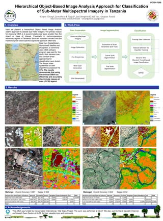
- 1. 4. Acknowledgements 1. Overview 2. Work-Flow Caspar Chung*, Jyoteshwar R Nagol*, Jan Dempewolf, Xin Tao, Anupam Anand Global Land Cover Facility, University of Maryland. *cchung7@umd.edu, jnagol@umd.edu Hierarchical Object-Based Image Analysis Approach for Classification of Sub-Meter Multispectral Imagery in Tanzania Image Segmentation Coarse Scale Segmentation Fine Scale Segmentation Estimation of Scale Parameter (ESP Tool) Data Preparation Ortho-rectified Raw Imagery Image Calibration NDVI layer Generation Pan Sharpening DEM (Resampled) Classification Decision Tree (Random Forest) based Image Classification Training Data Collection QA/QC Feature Selection for Classifier Training 3. Results Data from DigitalGlobe's WorldView2 satellite and eCognition, a commonly used OBIA software program was used for this study. Both decision tree and random forest approaches for classification were tested. The Kappa index agreement for both algorithms surpassed the 85%. The results demonstrate that using hierarchical OBIA can effectively and accurately discriminate classes at even LCCS3 legend. Here we present a hierarchical Object Based Image Analysis (OBIA) approach to classify sub-meter imagery. The primary reason for choosing OBIA is to accommodate pixel sizes smaller than the object or class of interest. Especially in nonhomogeneous savannah regions of Tanzania, this is an important concern and the traditional pixel based spectral signature approach often fails. Mahenge Overall Accuracy: 0.967 Kappa: 0.958 Decision tree level/Types of features Spectral Geometry Texture Neighbor Super/Subobjects Soil DEM High level (1st to 5th node) 7(25%) 2(15.3%) 0 2(50%) 1(33.3%) 0 1(100%) Medium level (6th to 10th node) 18(64.2%) 6(46.1%) 5(83.3%) 2(50%) 2(66.6%) 3 (75%) 0 Low level (11th to 14th node) 3(10.7%) 5(38.4%) 1(16.6%) 0 0 1(25%) 0 Total 28 13 6 4 3 4 1 Malangali Overall Accuracy: 0.949 Kappa:0.932 Decision tree level/Types of features Spectral Geometry Texture Neighbor Super/Subobjects Soil DEM High level (1st to 3rd node) 2(20%) 0 1(25%) 0 0 0 0 Medium level (4th to 8th node) 6(60%) 2(66.6%) 1(25%) 2(50%) 0 2(66.6%) 0 Low level (9th to 11th node) 2(20%) 1(33.3%) 2(50%) 2(50%) 1(100%) 1(33/3%) 1(100%) Total 10 3 4 4 1 3 1 Legend Agriculture Rock/gravel Soil Road Roof Riparian trees Trees Shrubland Grass Water Tree shadow Cloud/shadow This effort was funded by Conservation International, Vital Signs Project. The work was performed at GLCF. We also want to thank Saurabh Channan and Joseph Owen Sexton at GLCF for their valuable input and comments. GC13H-1250 Legend Agriculture Rock/gravel Soil Road Trail Roof Riparian trees Trees Shrubland Grass Water Shadow