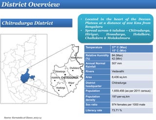
CHITRADURGA
District Profile
Snapshot – Chitradurga District Profile
Contents
District overview
Economic Profile
Agricultural Profile
Industry Profile
Power and Water
Tourism
Social Infrastructure
Connectivity
Infrastructure Readiness
Potential Industries
Investment Opportunities
Annexure
Temperature 37° C (Max)
15° C (Min)
Relative Humidity
(%)
84 (Max)
42 (Min)
Annual Normal
Rainfall
507 mm
Rivers Vedavathi
Area 8,436 sq.km
District
headquarter
Chitradurga
Population 1,659,456 (as per 2011 census)
Population
density
197-per-sq.km
Sex ratio 974 females per 1000 male
Literacy rate 73.71 %
• Located in the heart of the Deccan
Plateau at a distance of 202 Kms from
Bengaluru
• Spread across 6 talukas – Chitradurga,
Hiriyur, Hosadurga, Holalkere,
Challakere & Molakalmuru
Chitradurga District
District Overview
.
Source: Karnataka at Glance, 2013-14
Economic Profile
GDDP is Rs. 5,226 Crores for the district in
the year 2012-13
Per capita annual income in the district is Rs.
47,534 for the year 2012-13
1
2
Bellary District’s Contribution to GSDP
of Karnataka (2012-13)
Description INR
Crore
Contribution (%)
Total District GDP 5,226 1.7
Agriculture and Allied
(Agriculture, animal
husbandry, Forestry,
Fishing)
1,506 3.5
Industry
(manufacturing,
Construction, Mining)
1,195 1.4
Services
(Real estate, Hotels and
restaurants, banking,
and legal services)
2,523 1.4
Chitradurga GDP Trend (in INR Crore)
4544
4237
4641
4965
4560
5226
2007-08 2008-09 2009-10 2010-11 2011-12 2012-13
Primary Secondary Tertiary GDDP
Source: State and District Domestic Product of Karnataka 14-15
Thrust Areas
• Improving Agricultural
productivity
• Improving seed varieties,
advanced agricultural
technology and
mechanization
• Contract farming with
technology and knowledge
transfer initiatives
• Facilities for processing and
post harvest handling
techniques
• Drought tolerant agriculture
Agricultural Profile
Major Crops
Major food crops - Paddy, Ragi,
Jowar and Maize
Pulses and seed crops - Red
gram, Horse gram, Green gram,
Black gram, Bengal gram and Tur
Commercial crops – Groundnut,
Sunflower, Cotton and Tobacco
District Infrastructure
 Akshaya Food park Ltd.
- 106 Acres Food park at
Hiriyur with an investment
of Us$ 3.4 million (INR 16
Crores)
 V.V.Sagar fish seed
farm Established to
produce and supply quality
fish seed for the
development of fishery in
district
Key Enablers
• Ideal agro climatic conditions for
growing horticulture crops
particularly for fruit crops
• Rich in animal wealth. As per the
17th livestock census, the total
cattle population of the district is
1.5 Million and poultry population
is 0.9 Million
• Good network of transportation
with 2 National Highways and
State Highways
• Significant contribution in oil
seed production
Forests
9.57%
Other
uncultivated
land
15.79%
Net Sown
Area (NSA)
50.59%
Remaining
Area
24.06%
Land Utilisation (%)
Cereals
40.74%
Pulses
11.57%
Oilseeds
31.27%
Commercial
crops
7.28%
others
9.14%
Cropping Pattern (%)
Source: Karnataka at Glance, DIC- Chitradurga
Total Land area- 770,702 Ha
S.No Industrial Areas Extent
(in acres)
1 Kelakote 87
• 13 Large and Medium scale Industries
with aggregated investment INR 398
Crore
• 9,345 small-scale industries with
aggregated investment INR 181 Crores
• 1 Industrial Area and 3 Industrial
Estates
Industry Profile
Industry Areas/Estates
S.No Industrial Estate Extent
(in acres)
1 Chitradurga/ M.K Hatti 10/8
2 Hosadurga 9.36
3 Hiriyur 13.14
 Planned eight-lane road from Bidar-Bangalore via
Chitradurga, Chitradurga-Mangalore and Chitradurga-
Hospet-Bagalkot-Bijapur
 Proposed Air strip, Industrial Area &
Industrial Estate, Cement Zone and a Power
Generation Zone covering the district
 Proposed 1810 Acre park for Defence
Industries in district
 Artisan Clusters – Textile Handlooms , Textile
Hand Printed
 Chitradurga comes under Zone-3 as per the state
industrial policy
 Indian Institute of Sciences is coming up with
second campus in Chitradurga spread over 2,000
acres of land
Industrial Areas
Industrial Estates
1
1
2
3
Map of Chitradurga District
Natural Resources
• Copper
• Quartz
• Building Stone
• Iron Ore
• Granite
• Manganese
• Dolomite
Source: DIC- Chitradurga
Water
 Vedavathi, a tributary of Tungabhadra flows through
the district
 Apart from the existing rivers and rainfall, reservoirs
and tanks are extensively used for water storage
 Average demand in the district (Industry and
Domestic)-9,31,950 litres/day
 Average consumption in the district- 7,92,157
litres/day
Power
 Transmission in the district is being done by
Bangalore Electricity Supply Company Limited (BESCOM)
 The district receives power from Sharavati Hydel
Generating Station
 One receiving station in Hiriyur with capacity of 220 MVA
 The district has 91 Wind Mills in Chitradurga and Hiriyur
generating 21.74 MW power
 Welspun Energy Limited (WEL) has commissioned its
first solar project in Chitradurga of 8.02-MW(DC)
capacity
 Average demand in the district 14,028.85 Lakhs units
 Average annual consumption
Industry-464.27 Lakhs units
Domestic- 1060.75 Lakhs units
Power and Water
Source: DIC- Chitradurga
Tourism
• Chitradurga Fort - Built on the North Eastern base and embellished with extensive fortifications, ramparts, bastions,
watchtowers and entrances located at strategic points with fourteen temples.
• Chandravalli - Ancient archaeological site of the Chitradurga hill.
• Sirigere - Known for Veershaiva Mutt of Taralabalu Jagadguru; located northwest of Chitradurga.
• Bruhanmutt - Known as Sri. Murugarajendra Matt; built in honour of an eminent guru of the Veershaiva and located
about 3 kms from Chitradurga.
• Aadumalleshwara - Shiva Cave temple built by Aadooru Mallapa; located 5 kms. from Chitradurga.
• Thamatekallu - Oldest hero stone in Karnataka and located 8 kms from Chitradurga.
• Jogimatti Hill Station – It is named after a yogi. The Himavatkedra waterfall that flows through the rocks has created a
natural cave that has a Shiva Linga and idols of Veerabhadra and Basavanna.
• Vani Vilas Sagar – It is an artificial lake , also called Marie Kanive built by Maharaja of Mysore, built across river
Vedavathi. It has two pavillion halls built in the saracenic style and is considered an engineering marvel.
Social Infrastructure
Healthcare:
Education:
Healthcare Facilities No.
Primary Health centres 62
Major Hospitals and Community
Health Centres
80
Key educational Institutes:
• Sree Venkateshwara College of Education
• Basaveshwara Medical College & Hospital
• SJM Dental College And Hospital
• SJMIT College of Engineering
• District Institute Of Education & Training
• Venkateshwara First Grade College
• Bapuji Ayurvedic Medical College
• Govt science collage
• SRS college
• Smt Neelamma A Hanumanthappa College
Science Hubs to be developed by
IISc, ISRO, DRDO & BARC over
8,000 acres
Key Educational Institutes
SJMIT College of
Engineering
Basaveshwara Medical College
Educational Institution No.
General Degree Colleges 21
Dental Colleges 1
Polytechnic Colleges 3
Engineering Colleges 1
Source: DIC-Chitradurga , targetstudy.com
Connectivity
 NH4 (Connects Mumbai, Pune, Bangalore and
Chennai)
 NH13 (Solapur in Maharashtra to Mangalore
in Karnataka) passes through the district
 Broad gauge railway route length of 165.27 kms
(102.69 miles) connecting Bengaluru to Ballari
passes through Holalkere and Chitradurga
International
Airport
521 Km
Internatio
nal Airport
203 Km
Port
Interna
tional
Airport
308 Km
Nearest Airport
Bengaluru 203
Hubballi 208
Mysuru 260
Mangaluru 308
Bengaluru 203
Nearest Seaport
Mangaluru 308
Karwar 320
Goa 383
Chennai 556
Infrastructure Readiness
Bengaluru – Mumbai Economic Corridor
Chitradurga Node
Davanagere City
Challakere
Chitradurga City
Hospete
NH 4
NH 13
Begaluru-Mumbai rail
link
Ballari
Airport to
node (100
km)
18 km from Chitradurga,
58 km from Davanagere
DRDO-IISC lands
SH 65
Proposed Node opt 1
Chikkagondanahalli- Sangenahalli-
Donnehalli (Davanagere-
Chitradurga District Border)
 Located on NH 13 and in close
proximity to Hubballi airport
and New Mangaluru seaport.
 Total land area estimated for
the node development is 15554
acres
 Land acquisition process has
been initiated for 9870 acres
 Chitradurga Node has the
potential to become globally
competitive in Aerospace and
defence
Hiryur Textile Park
Food Park
Akshay Food Park is spread over an 106
acres with cold storage and processing
facilities
A textile park is been approved to be set up
by Binary Apparel Park Private Ltd.
Energy:
• 4th largest producer of wind
energy with a capacity of 1472.75
MW
• District has one of the high wind
sites in the country with over
20,000 wind turbines
• Best performance in the country
by district wind farms recording a
capacity factor of 38.5%
• Proposed 21 MW EWKL Wind
Farm.
Potential Industries
Textile and Handloom
Industries:
• Textile constitutes second
highest number of Large &
Medium industries in the
district and around 12% of SSI
units in the district.
• Among the highest
investment attracting sectors.
• 3 artisan clusters in Textile
Handlooms and Hand
Printing
Mining:
• Rich in resources like Iron &
manganese Ore, Copper and
Green Quartz
• Limestone reserves estimated
to the tune of 93.05 million
tonnes
• Prominent gold mines at
Halekal, Kotemardi &
Bedimaradi & open cast
copper mines at Ingaldhal
Food Processing:
• A Large number of SSI units
are engaged in food
processing sector creating an
eco system and supply of
skilled labour.
• More than 20% of the SSI
units in the district are
engaged in Agro and food
processing activities
Cement:
• District has large proven
limestone reserves
• Presence of Large & Medium
Industries in cement sector
• Emerging contender for
cement and steel
Others:
• Industries include 1 gold
mine, 3 textile industries, 7
edible oil industry, 1 power
industry and 1 cement
industry
Investment Opportunities
Project Name Sector
Estimated
Cost (INR
Crores)
Estimated Cost
(USD mn)
Agency Status
Development Of Road From Chitradurga –
Chellakere Pavagada Ap Border
Transportation
Part of 7000 Part of 1166.7
Tourism
Department
Conceptualization
Setting Up Of Conduit For Ofc (Optical Fibre
Cables) For Broad Band And Cable Tv
Operators Using Bescom Electric Poles
Urban
Infrastructure
(telecommunic
ation)
NA
0.0
BESCOM Conceptualization
Peninsular Region Industrial Development
(PRIDE) Corridor Projects
Industrial
Infrastructure
NA
0.0
KSIIDC
DPR
Completed/Bidding
Stage
• Proposed Industrial Estate at Doddaullarthi, Challakere- Notification issued for land
acquisitions
• Proposed Industrial Estate at Kudapura Farm, Challakere- Notification issued for land
acquisitions
• Proposed Industrial Area at Chitradurga town 2nd stage of IA,Kelagote - Notification issued for
land acquisitions
• Proposed Industrial Area at Pillai,Hiriyur and Gunderi,Holalkere – Notification issued for land
acquisitions
Additional Projects
Annexure
Key Players
Other Key Players:
Madras Cement Pvt. Ltd.
Welspun
R.K. Powergen
V.S.L. Steel Ltd.
Sunray Industries
Prakash sponge Irone & Power Pvt
Habib protence & Fats, Metikurke
Amruth Organicks
Contact
Karnataka Udyog Mitra
3rd Floor, Khanija Bhavan (East Wing),
No. 49, Race Course Road, Bengaluru-560 001, India
Ph.: +91 80 2228 2392, 2228 5659, 2238 1232,
2228 6632
Fax: +91 80 2226 6063
Email: md@kumbangalore.com
visit us at: www.investkarnataka.gov.in
The Joint Director
District Industries Centre (DIC)
Jogimatt Road Chitradurga - 577501.
Ph: (+91-8194) 235994, 235817,235783
Email: jd-cdurga@karnatakaindustry.gov.in
Commissioner for Industries Development and Director
Department of Industries & Commerce
Government of Karnataka
No. 49, South Block, Khanija Bhavan,
Race Course Road, Bengaluru-560 001, India
Ph.: +91 80 2238 6796
Email: commissioner@karnatakaindustry.gov.in

Chitradurga district profile

  • 1.
  • 2.
    Snapshot – ChitradurgaDistrict Profile Contents District overview Economic Profile Agricultural Profile Industry Profile Power and Water Tourism Social Infrastructure Connectivity Infrastructure Readiness Potential Industries Investment Opportunities Annexure
  • 3.
    Temperature 37° C(Max) 15° C (Min) Relative Humidity (%) 84 (Max) 42 (Min) Annual Normal Rainfall 507 mm Rivers Vedavathi Area 8,436 sq.km District headquarter Chitradurga Population 1,659,456 (as per 2011 census) Population density 197-per-sq.km Sex ratio 974 females per 1000 male Literacy rate 73.71 % • Located in the heart of the Deccan Plateau at a distance of 202 Kms from Bengaluru • Spread across 6 talukas – Chitradurga, Hiriyur, Hosadurga, Holalkere, Challakere & Molakalmuru Chitradurga District District Overview . Source: Karnataka at Glance, 2013-14
  • 4.
    Economic Profile GDDP isRs. 5,226 Crores for the district in the year 2012-13 Per capita annual income in the district is Rs. 47,534 for the year 2012-13 1 2 Bellary District’s Contribution to GSDP of Karnataka (2012-13) Description INR Crore Contribution (%) Total District GDP 5,226 1.7 Agriculture and Allied (Agriculture, animal husbandry, Forestry, Fishing) 1,506 3.5 Industry (manufacturing, Construction, Mining) 1,195 1.4 Services (Real estate, Hotels and restaurants, banking, and legal services) 2,523 1.4 Chitradurga GDP Trend (in INR Crore) 4544 4237 4641 4965 4560 5226 2007-08 2008-09 2009-10 2010-11 2011-12 2012-13 Primary Secondary Tertiary GDDP Source: State and District Domestic Product of Karnataka 14-15
  • 5.
    Thrust Areas • ImprovingAgricultural productivity • Improving seed varieties, advanced agricultural technology and mechanization • Contract farming with technology and knowledge transfer initiatives • Facilities for processing and post harvest handling techniques • Drought tolerant agriculture Agricultural Profile Major Crops Major food crops - Paddy, Ragi, Jowar and Maize Pulses and seed crops - Red gram, Horse gram, Green gram, Black gram, Bengal gram and Tur Commercial crops – Groundnut, Sunflower, Cotton and Tobacco District Infrastructure  Akshaya Food park Ltd. - 106 Acres Food park at Hiriyur with an investment of Us$ 3.4 million (INR 16 Crores)  V.V.Sagar fish seed farm Established to produce and supply quality fish seed for the development of fishery in district Key Enablers • Ideal agro climatic conditions for growing horticulture crops particularly for fruit crops • Rich in animal wealth. As per the 17th livestock census, the total cattle population of the district is 1.5 Million and poultry population is 0.9 Million • Good network of transportation with 2 National Highways and State Highways • Significant contribution in oil seed production Forests 9.57% Other uncultivated land 15.79% Net Sown Area (NSA) 50.59% Remaining Area 24.06% Land Utilisation (%) Cereals 40.74% Pulses 11.57% Oilseeds 31.27% Commercial crops 7.28% others 9.14% Cropping Pattern (%) Source: Karnataka at Glance, DIC- Chitradurga Total Land area- 770,702 Ha
  • 6.
    S.No Industrial AreasExtent (in acres) 1 Kelakote 87 • 13 Large and Medium scale Industries with aggregated investment INR 398 Crore • 9,345 small-scale industries with aggregated investment INR 181 Crores • 1 Industrial Area and 3 Industrial Estates Industry Profile Industry Areas/Estates S.No Industrial Estate Extent (in acres) 1 Chitradurga/ M.K Hatti 10/8 2 Hosadurga 9.36 3 Hiriyur 13.14  Planned eight-lane road from Bidar-Bangalore via Chitradurga, Chitradurga-Mangalore and Chitradurga- Hospet-Bagalkot-Bijapur  Proposed Air strip, Industrial Area & Industrial Estate, Cement Zone and a Power Generation Zone covering the district  Proposed 1810 Acre park for Defence Industries in district  Artisan Clusters – Textile Handlooms , Textile Hand Printed  Chitradurga comes under Zone-3 as per the state industrial policy  Indian Institute of Sciences is coming up with second campus in Chitradurga spread over 2,000 acres of land Industrial Areas Industrial Estates 1 1 2 3 Map of Chitradurga District Natural Resources • Copper • Quartz • Building Stone • Iron Ore • Granite • Manganese • Dolomite Source: DIC- Chitradurga
  • 7.
    Water  Vedavathi, atributary of Tungabhadra flows through the district  Apart from the existing rivers and rainfall, reservoirs and tanks are extensively used for water storage  Average demand in the district (Industry and Domestic)-9,31,950 litres/day  Average consumption in the district- 7,92,157 litres/day Power  Transmission in the district is being done by Bangalore Electricity Supply Company Limited (BESCOM)  The district receives power from Sharavati Hydel Generating Station  One receiving station in Hiriyur with capacity of 220 MVA  The district has 91 Wind Mills in Chitradurga and Hiriyur generating 21.74 MW power  Welspun Energy Limited (WEL) has commissioned its first solar project in Chitradurga of 8.02-MW(DC) capacity  Average demand in the district 14,028.85 Lakhs units  Average annual consumption Industry-464.27 Lakhs units Domestic- 1060.75 Lakhs units Power and Water Source: DIC- Chitradurga
  • 8.
    Tourism • Chitradurga Fort- Built on the North Eastern base and embellished with extensive fortifications, ramparts, bastions, watchtowers and entrances located at strategic points with fourteen temples. • Chandravalli - Ancient archaeological site of the Chitradurga hill. • Sirigere - Known for Veershaiva Mutt of Taralabalu Jagadguru; located northwest of Chitradurga. • Bruhanmutt - Known as Sri. Murugarajendra Matt; built in honour of an eminent guru of the Veershaiva and located about 3 kms from Chitradurga. • Aadumalleshwara - Shiva Cave temple built by Aadooru Mallapa; located 5 kms. from Chitradurga. • Thamatekallu - Oldest hero stone in Karnataka and located 8 kms from Chitradurga. • Jogimatti Hill Station – It is named after a yogi. The Himavatkedra waterfall that flows through the rocks has created a natural cave that has a Shiva Linga and idols of Veerabhadra and Basavanna. • Vani Vilas Sagar – It is an artificial lake , also called Marie Kanive built by Maharaja of Mysore, built across river Vedavathi. It has two pavillion halls built in the saracenic style and is considered an engineering marvel.
  • 9.
    Social Infrastructure Healthcare: Education: Healthcare FacilitiesNo. Primary Health centres 62 Major Hospitals and Community Health Centres 80 Key educational Institutes: • Sree Venkateshwara College of Education • Basaveshwara Medical College & Hospital • SJM Dental College And Hospital • SJMIT College of Engineering • District Institute Of Education & Training • Venkateshwara First Grade College • Bapuji Ayurvedic Medical College • Govt science collage • SRS college • Smt Neelamma A Hanumanthappa College Science Hubs to be developed by IISc, ISRO, DRDO & BARC over 8,000 acres Key Educational Institutes SJMIT College of Engineering Basaveshwara Medical College Educational Institution No. General Degree Colleges 21 Dental Colleges 1 Polytechnic Colleges 3 Engineering Colleges 1 Source: DIC-Chitradurga , targetstudy.com
  • 10.
    Connectivity  NH4 (ConnectsMumbai, Pune, Bangalore and Chennai)  NH13 (Solapur in Maharashtra to Mangalore in Karnataka) passes through the district  Broad gauge railway route length of 165.27 kms (102.69 miles) connecting Bengaluru to Ballari passes through Holalkere and Chitradurga International Airport 521 Km Internatio nal Airport 203 Km Port Interna tional Airport 308 Km Nearest Airport Bengaluru 203 Hubballi 208 Mysuru 260 Mangaluru 308 Bengaluru 203 Nearest Seaport Mangaluru 308 Karwar 320 Goa 383 Chennai 556
  • 11.
    Infrastructure Readiness Bengaluru –Mumbai Economic Corridor Chitradurga Node Davanagere City Challakere Chitradurga City Hospete NH 4 NH 13 Begaluru-Mumbai rail link Ballari Airport to node (100 km) 18 km from Chitradurga, 58 km from Davanagere DRDO-IISC lands SH 65 Proposed Node opt 1 Chikkagondanahalli- Sangenahalli- Donnehalli (Davanagere- Chitradurga District Border)  Located on NH 13 and in close proximity to Hubballi airport and New Mangaluru seaport.  Total land area estimated for the node development is 15554 acres  Land acquisition process has been initiated for 9870 acres  Chitradurga Node has the potential to become globally competitive in Aerospace and defence Hiryur Textile Park Food Park Akshay Food Park is spread over an 106 acres with cold storage and processing facilities A textile park is been approved to be set up by Binary Apparel Park Private Ltd.
  • 12.
    Energy: • 4th largestproducer of wind energy with a capacity of 1472.75 MW • District has one of the high wind sites in the country with over 20,000 wind turbines • Best performance in the country by district wind farms recording a capacity factor of 38.5% • Proposed 21 MW EWKL Wind Farm. Potential Industries Textile and Handloom Industries: • Textile constitutes second highest number of Large & Medium industries in the district and around 12% of SSI units in the district. • Among the highest investment attracting sectors. • 3 artisan clusters in Textile Handlooms and Hand Printing Mining: • Rich in resources like Iron & manganese Ore, Copper and Green Quartz • Limestone reserves estimated to the tune of 93.05 million tonnes • Prominent gold mines at Halekal, Kotemardi & Bedimaradi & open cast copper mines at Ingaldhal Food Processing: • A Large number of SSI units are engaged in food processing sector creating an eco system and supply of skilled labour. • More than 20% of the SSI units in the district are engaged in Agro and food processing activities Cement: • District has large proven limestone reserves • Presence of Large & Medium Industries in cement sector • Emerging contender for cement and steel Others: • Industries include 1 gold mine, 3 textile industries, 7 edible oil industry, 1 power industry and 1 cement industry
  • 13.
    Investment Opportunities Project NameSector Estimated Cost (INR Crores) Estimated Cost (USD mn) Agency Status Development Of Road From Chitradurga – Chellakere Pavagada Ap Border Transportation Part of 7000 Part of 1166.7 Tourism Department Conceptualization Setting Up Of Conduit For Ofc (Optical Fibre Cables) For Broad Band And Cable Tv Operators Using Bescom Electric Poles Urban Infrastructure (telecommunic ation) NA 0.0 BESCOM Conceptualization Peninsular Region Industrial Development (PRIDE) Corridor Projects Industrial Infrastructure NA 0.0 KSIIDC DPR Completed/Bidding Stage • Proposed Industrial Estate at Doddaullarthi, Challakere- Notification issued for land acquisitions • Proposed Industrial Estate at Kudapura Farm, Challakere- Notification issued for land acquisitions • Proposed Industrial Area at Chitradurga town 2nd stage of IA,Kelagote - Notification issued for land acquisitions • Proposed Industrial Area at Pillai,Hiriyur and Gunderi,Holalkere – Notification issued for land acquisitions Additional Projects
  • 14.
    Annexure Key Players Other KeyPlayers: Madras Cement Pvt. Ltd. Welspun R.K. Powergen V.S.L. Steel Ltd. Sunray Industries Prakash sponge Irone & Power Pvt Habib protence & Fats, Metikurke Amruth Organicks
  • 15.
    Contact Karnataka Udyog Mitra 3rdFloor, Khanija Bhavan (East Wing), No. 49, Race Course Road, Bengaluru-560 001, India Ph.: +91 80 2228 2392, 2228 5659, 2238 1232, 2228 6632 Fax: +91 80 2226 6063 Email: md@kumbangalore.com visit us at: www.investkarnataka.gov.in The Joint Director District Industries Centre (DIC) Jogimatt Road Chitradurga - 577501. Ph: (+91-8194) 235994, 235817,235783 Email: jd-cdurga@karnatakaindustry.gov.in Commissioner for Industries Development and Director Department of Industries & Commerce Government of Karnataka No. 49, South Block, Khanija Bhavan, Race Course Road, Bengaluru-560 001, India Ph.: +91 80 2238 6796 Email: commissioner@karnatakaindustry.gov.in