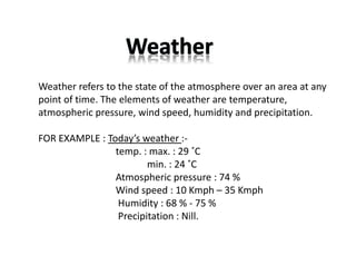
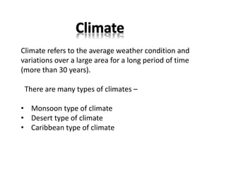
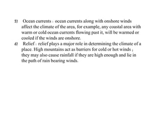
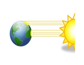
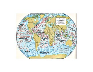
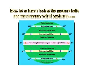
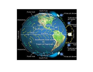
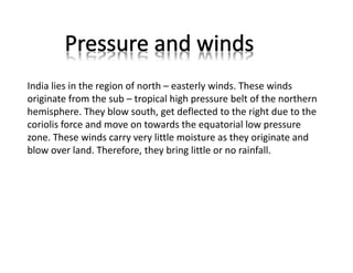
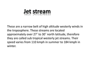
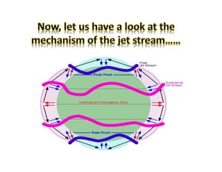
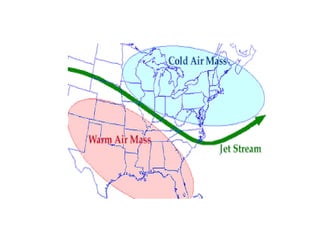
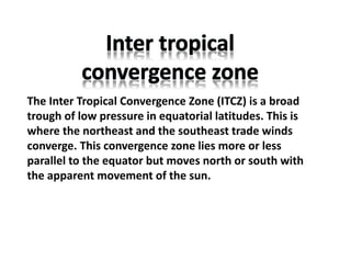
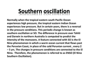
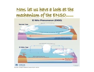
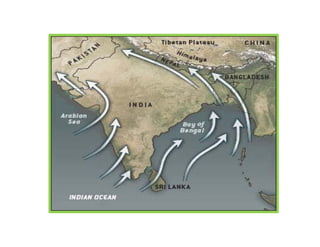
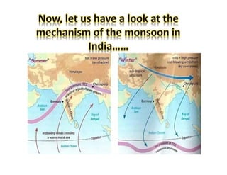
Weather refers to the state of the atmosphere over an area at any
point of time. The elements of weather are temperature,
atmospheric pressure, wind speed, humidity and precipitation.
FOR EXAMPLE : Today’s weather :‐
temp. : max. : 29 ˚C
min. : 24 ˚C
Atmospheric pressure : 74 %
Wind speed : 10 Kmph – 35 Kmph
Humidity : 68 % ‐ 75 %
Precipitation : Nill.
Climate refers to the average weather condition and
variations over a large area for a long period of time
(more than 30 years).
There are many types of climates –
• Monsoon type of climate
• Desert type of climate
• Caribbean type of climate
There are six major controls of the climate of any place –
1) Latitude – due to the curvature of the earth, the amount of
solar energy received varies according to latitude.
2) Altitude – as one goes from the surface of the earth to higher
altitudes, the atmosphere becomes less dense and temperature
decreases.
3) Pressure & wind system : the pressure and wind system of any
area depend on the latitude and altitude of the place. Thus it
influences the temperature and rainfall pattern.
4) Distance from the sea (continentality) : as the distance from the
sea increases, its moderating influence decreases and the
people experience extreme weather conditions. This condition
is known as continentality.
5) Ocean currents : ocean currents along with onshore winds
affect the climate of the area, for example, any coastal area with
warm or cold ocean currents flowing past it, will be warmed or
cooled if the winds are onshore.
6) Relief : relief plays a major role in determining the climate of a
place. High mountains act as barriers for cold or hot winds ;
they may also cause rainfall if they are high enough and lie in
the path of rain bearing winds.
1) Latitude : the Tropic of Cancer passes through the middle of the
country from the Rann of Kuchh in the west to Mizoram in the
east. Almost half of the country lying south of the Tropic of
Cancer, belongs to the tropical area. All the remaining area,
north of the Tropic, lies in the sub – tropics.
2) Altitude : India has mountains to the north which have an
average elevation of 6000 metres. India also has a vast coastline
area where the maximum elevation is about 30 metres. The
Himalayas prevent the cold winds from central Asia from
entering the sub – continent. It is because of these mountains
that this sub – continent experiences comparatively milder
winters than central Asia.
3) Pressure and wind system : the climate and associated weather
conditions in India are governed by the following atmospheric
conditions –
 pressure and surface winds
 upper air circulation
 western cyclonic disturbances and tropical cyclones
4) Ocean currents : ocean currents along with onshore winds affect
the climate of the area, for example, any coastal area with warm or
cold ocean currents flowing past it, will be warmed or cooled if the
winds are onshore.
5) Distance from the sea : as the distance from the sea increases, its
moderating influence decreases and the people experience extreme
weather conditions. This condition is known as continentality.
6) Relief features : High mountains act as barriers for cold or hot
winds ; they may also cause rainfall if they are high enough and lie in
the path of rain bearing winds. The leeward side of the mountain
remains relatively dry.
An apparent force caused by the earth’s rotation, the
coriolis force is responsible for deflecting towards the right
in the northern hemisphere and towards the left in the
southern hemisphere.
India lies in the region of north – easterly winds. These winds
originate from the sub – tropical high pressure belt of the northern
hemisphere. They blow south, get deflected to the right due to the
coriolis force and move on towards the equatorial low pressure
zone. These winds carry very little moisture as they originate and
blow over land. Therefore, they bring little or no rainfall.
The pressure and wind condition over India are unique. During
winter, there is a high pressure area north of the Himalayas. Cold,
dry winds blow from this region to the south. In summer, a low
pressure area develops over interior Asia as well as over north –
western India. This causes a complete reversal of the direction of
the winds during summer. Air moves from the high pressure area
over the southern Indian Ocean, in a south –easterly direction,
crosses the equator and turns right towards the low pressure area
over the Indian sub – continent. These are known as southwest
monsoon winds. direction, crosses the equator and turns right
towards the low pressure area over the Indian sub – continent.
These are known as southwest monsoon winds.
These are a narrow belt of high altitude westerly winds in
the troposphere. These streams are located
approximately over 27˚ to 30˚ north latitude, therefore
they are called sub tropical westerly jet streams. Their
speed varies from 110 kmph in summer to 184 kmph in
winter.
The Inter Tropical Convergence Zone (ITCZ) is a broad
trough of low pressure in equatorial latitudes. This is
where the northeast and the southeast trade winds
converge. This convergence zone lies more or less
parallel to the equator but moves north or south with
the apparent movement of the sun.
Normally when the tropical eastern south Pacific Ocean
experiences high pressure, the tropical eastern Indian Ocean
experiences low pressure. But in certain years, there is a reversal
in the pressure conditions. This periodic change is known as
southern oscillation or SO. The difference in pressure over Tahiti
and Darwin in northern Australia is computed to predict the
intensity of the monsoons. A feature connected with SO is the El
Nino phenomenon in which a warm ocean current that flows past
the Peruvian Coast, in place of the cold Peruvian current , every 2
– 5 yrs. The changes in pressure conditions are connected to the El
Nino. Therefore, the phenomenon is referred to as ENSO (El Nino
Southern Oscillation).
The monsoon, unlike the traders, are not steady winds but are
pulsating in nature, affected by different atmospheric conditions
encountered by it, on its way over the warm tropical seas. The
duration of the monsoon is between 100 – 120 days from early June
to mid – September. Around the time of its arrival, the normal
rainfall increases suddenly and continues for several days. This is
known as the burst of monsoon.
There are four main seasons in India. They are –
i) The cold weather season (winter)
ii) The hot weather season (summer)
iii) Advancing monsoon (the rainy season)
iv) Retreating monsoon (the transition season)
The cold weather season begins from mid – November in northern
India and stays till February. December and January are the coldest
months in the northern part of India. During this season, the
northeast trade winds prevail over the country. The weather is
normally marked by clear skies, low temperatures and low humidity
and feeble variable winds. The peninsular region does not have a
well defined cold season. This season is important for Rabi crops.
The hot weather season begins from March and continues up to
May. In March, the highest temperature is about 38˚C recorded in
the Deccan plateau. In peninsular India, temperatures remain lower
due to the moderating influence of the oceans. A striking feature of
the hot weather season is the ‘loo’. These are strong, gusty, hot and
dry winds blowing during the day. Dust storms are very common
during the month of May in northern India. In West Bengal it is
known as ‘kaal baisakhi’. Towards the end of the summer season,
pre ‐ monsoon showers are common in Kerala and Karnataka.
By early June, the low pressure condition over the northern plains
intensifies. It attracts the trade winds of the southern hemisphere.
As these winds blow over warm oceans, they bring abundant
moisture to the sub – continent. The in flow of the southwest
monsoon in India brings about a total change in the weather. The
maximum rainfall of this season is received in the northeastern part
of the country.
During October – November with the apparent movement of the
sun towards the south, the monsoon or the low pressure trough
becomes weaker. This gradually replaced by a high pressure system.
By the beginning of October, the monsoon withdraws from the
northern plains. It is marked by clear sky and rise in temperature.
The low pressure conditions, over northwestern India get
transferred to the Bay of Bengal by early November.

Ch 4 Climate 2.pdfclass 9 social geography

  • 2.
    Weather refers tothe state of the atmosphere over an area at any point of time. The elements of weather are temperature, atmospheric pressure, wind speed, humidity and precipitation. FOR EXAMPLE : Today’s weather :‐ temp. : max. : 29 ˚C min. : 24 ˚C Atmospheric pressure : 74 % Wind speed : 10 Kmph – 35 Kmph Humidity : 68 % ‐ 75 % Precipitation : Nill.
  • 3.
    Climate refers tothe average weather condition and variations over a large area for a long period of time (more than 30 years). There are many types of climates – • Monsoon type of climate • Desert type of climate • Caribbean type of climate
  • 4.
    There are sixmajor controls of the climate of any place – 1) Latitude – due to the curvature of the earth, the amount of solar energy received varies according to latitude. 2) Altitude – as one goes from the surface of the earth to higher altitudes, the atmosphere becomes less dense and temperature decreases. 3) Pressure & wind system : the pressure and wind system of any area depend on the latitude and altitude of the place. Thus it influences the temperature and rainfall pattern. 4) Distance from the sea (continentality) : as the distance from the sea increases, its moderating influence decreases and the people experience extreme weather conditions. This condition is known as continentality.
  • 5.
    5) Ocean currents: ocean currents along with onshore winds affect the climate of the area, for example, any coastal area with warm or cold ocean currents flowing past it, will be warmed or cooled if the winds are onshore. 6) Relief : relief plays a major role in determining the climate of a place. High mountains act as barriers for cold or hot winds ; they may also cause rainfall if they are high enough and lie in the path of rain bearing winds.
  • 10.
    1) Latitude :the Tropic of Cancer passes through the middle of the country from the Rann of Kuchh in the west to Mizoram in the east. Almost half of the country lying south of the Tropic of Cancer, belongs to the tropical area. All the remaining area, north of the Tropic, lies in the sub – tropics. 2) Altitude : India has mountains to the north which have an average elevation of 6000 metres. India also has a vast coastline area where the maximum elevation is about 30 metres. The Himalayas prevent the cold winds from central Asia from entering the sub – continent. It is because of these mountains that this sub – continent experiences comparatively milder winters than central Asia.
  • 11.
    3) Pressure andwind system : the climate and associated weather conditions in India are governed by the following atmospheric conditions –  pressure and surface winds  upper air circulation  western cyclonic disturbances and tropical cyclones 4) Ocean currents : ocean currents along with onshore winds affect the climate of the area, for example, any coastal area with warm or cold ocean currents flowing past it, will be warmed or cooled if the winds are onshore. 5) Distance from the sea : as the distance from the sea increases, its moderating influence decreases and the people experience extreme weather conditions. This condition is known as continentality. 6) Relief features : High mountains act as barriers for cold or hot winds ; they may also cause rainfall if they are high enough and lie in the path of rain bearing winds. The leeward side of the mountain remains relatively dry.
  • 12.
    An apparent forcecaused by the earth’s rotation, the coriolis force is responsible for deflecting towards the right in the northern hemisphere and towards the left in the southern hemisphere.
  • 14.
    India lies inthe region of north – easterly winds. These winds originate from the sub – tropical high pressure belt of the northern hemisphere. They blow south, get deflected to the right due to the coriolis force and move on towards the equatorial low pressure zone. These winds carry very little moisture as they originate and blow over land. Therefore, they bring little or no rainfall.
  • 15.
    The pressure andwind condition over India are unique. During winter, there is a high pressure area north of the Himalayas. Cold, dry winds blow from this region to the south. In summer, a low pressure area develops over interior Asia as well as over north – western India. This causes a complete reversal of the direction of the winds during summer. Air moves from the high pressure area over the southern Indian Ocean, in a south –easterly direction, crosses the equator and turns right towards the low pressure area over the Indian sub – continent. These are known as southwest monsoon winds. direction, crosses the equator and turns right towards the low pressure area over the Indian sub – continent. These are known as southwest monsoon winds.
  • 16.
    These are anarrow belt of high altitude westerly winds in the troposphere. These streams are located approximately over 27˚ to 30˚ north latitude, therefore they are called sub tropical westerly jet streams. Their speed varies from 110 kmph in summer to 184 kmph in winter.
  • 19.
    The Inter TropicalConvergence Zone (ITCZ) is a broad trough of low pressure in equatorial latitudes. This is where the northeast and the southeast trade winds converge. This convergence zone lies more or less parallel to the equator but moves north or south with the apparent movement of the sun.
  • 20.
    Normally when thetropical eastern south Pacific Ocean experiences high pressure, the tropical eastern Indian Ocean experiences low pressure. But in certain years, there is a reversal in the pressure conditions. This periodic change is known as southern oscillation or SO. The difference in pressure over Tahiti and Darwin in northern Australia is computed to predict the intensity of the monsoons. A feature connected with SO is the El Nino phenomenon in which a warm ocean current that flows past the Peruvian Coast, in place of the cold Peruvian current , every 2 – 5 yrs. The changes in pressure conditions are connected to the El Nino. Therefore, the phenomenon is referred to as ENSO (El Nino Southern Oscillation).
  • 22.
    The monsoon, unlikethe traders, are not steady winds but are pulsating in nature, affected by different atmospheric conditions encountered by it, on its way over the warm tropical seas. The duration of the monsoon is between 100 – 120 days from early June to mid – September. Around the time of its arrival, the normal rainfall increases suddenly and continues for several days. This is known as the burst of monsoon.
  • 24.
    There are fourmain seasons in India. They are – i) The cold weather season (winter) ii) The hot weather season (summer) iii) Advancing monsoon (the rainy season) iv) Retreating monsoon (the transition season)
  • 25.
    The cold weatherseason begins from mid – November in northern India and stays till February. December and January are the coldest months in the northern part of India. During this season, the northeast trade winds prevail over the country. The weather is normally marked by clear skies, low temperatures and low humidity and feeble variable winds. The peninsular region does not have a well defined cold season. This season is important for Rabi crops.
  • 26.
    The hot weatherseason begins from March and continues up to May. In March, the highest temperature is about 38˚C recorded in the Deccan plateau. In peninsular India, temperatures remain lower due to the moderating influence of the oceans. A striking feature of the hot weather season is the ‘loo’. These are strong, gusty, hot and dry winds blowing during the day. Dust storms are very common during the month of May in northern India. In West Bengal it is known as ‘kaal baisakhi’. Towards the end of the summer season, pre ‐ monsoon showers are common in Kerala and Karnataka.
  • 27.
    By early June,the low pressure condition over the northern plains intensifies. It attracts the trade winds of the southern hemisphere. As these winds blow over warm oceans, they bring abundant moisture to the sub – continent. The in flow of the southwest monsoon in India brings about a total change in the weather. The maximum rainfall of this season is received in the northeastern part of the country.
  • 29.
    During October –November with the apparent movement of the sun towards the south, the monsoon or the low pressure trough becomes weaker. This gradually replaced by a high pressure system. By the beginning of October, the monsoon withdraws from the northern plains. It is marked by clear sky and rise in temperature. The low pressure conditions, over northwestern India get transferred to the Bay of Bengal by early November.