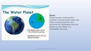
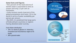
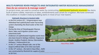
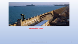
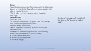
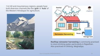
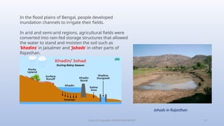
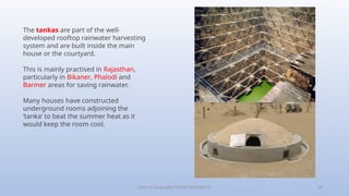
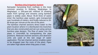
Class-10 Geography (WATER RESOURCES) 1
Prepared by: Tapan Kumar Bhoi
TGT Social Science
OAV, Lathikata, Sundargarh
Class-10 Geography (WATER RESOURCES) 2
Class-10 Geography (WATER RESOURCES) 3
Topics in the Chapter
• Water
Some facts and Figures
→
• Dams
• Multi-purpose river projects
→ Objectives of multi-purpose river projects
→ Disadvantages of Multi-purpose river projects
→ Movements against Multi-purpose river projects
• Rainwater Harvesting
→ How Tankas works
Class-10 Geography (WATER RESOURCES) 4
Water
Three-fourths of the earth’s
surface is covered with water, but
only a small proportion of it
accounts for freshwater that can
be put to use. Water is a
renewable resource.
Class-10 Geography (WATER RESOURCES) 5
Some facts and Figures
• 96.5 percent of the total volume of
world’s water is estimated to exist as
oceans and only 2.5 per cent as
freshwater.
• India receives nearly 4 percent of the
global precipitation and ranks 133 in the
world in terms of water availability per
person per annum.
• By 2025, it is predicted that large parts
of India will join countries or regions
having absolute water scarcity.
Fresh Water distribution
• 70%- ice sheets & glaciers in Antarctica,
Greenland and mountainous region of th
world.
• 30%- ground water
Class-10 Geography (WATER RESOURCES) 6
Class-10 Geography (WATER RESOURCES) 7
Class-10 Geography (WATER RESOURCES) 8
Water Scarcity and the Need for Water
Conservation and Management
The availability of water resources varies over
space and time.
•Water scarcity is caused by over-exploitation,
excessive use and unequal access to water
among different social groups.
•Water resources are being over-exploited to
expand irrigated areas for dry-season
agriculture.
•In some areas, water is sufficiently available
to meet the needs of the people. But, those
areas still suffer from water scarcity due to bad
quality of water.
Class-10 Geography (WATER RESOURCES) 9
Where is the water scarcity likely to occur?
Hydrological cycle
Is it possible that an area or region
may have ample water resources
but is still facing water scarcity?
Reason for Water Scarcity:
• Large & growing population
• Unequal access to water
• Over exploitation
• Over irrigation
• Intensive Industrialisation
• Urbanisation
• Pollution of water
According to reports many of our
Indian river is being polluted and
its water can’t be used.
Eg. Ganga, Yamuna
Class-10 Geography (WATER RESOURCES) 10
The need of the hour is to conserve and manage
our water resources. How do we do it?
•Safeguard ourselves from health hazards.
•Ensure food security, continuation of our livelihoods
and productive activities.
•Prevent the degradation of our natural ecosystems.
Class-10 Geography (WATER RESOURCES) 11
MULTI-PURPOSE RIVER PROJECTS AND INTEGRATED WATER RESOURCES MANAGEMENT
How do we conserve & manage water?
In ancient times, we used to conserve water by constructing sophisticated hydraulic structures like dams
built of stone rubble, reservoirs or lakes, embankments and canals for irrigation. We have continued
this tradition in modern India by building dams in most of our river basins.
Hydraulic Structure in Ancient India
• In the first century B.C., Sringaverapura near
Allahabad had sophisticated water harvesting
system channeling the flood water of the river
Ganga.
• During the time of Chandragupta Maurya,
dams, lakes and irrigation system were
extensively built.
• Evidences of sophisticated irrigation works have
also been found in Kalinga (Odisha), Nagarjuna
Konda ( Andhra Pradesh), Bennur (Karnataka),
Kolhapur ( Maharashtra) etc.
• In the 11th
century Bhopal Lake, one of the
largest artificial lakes of its time was built.
• In the 14th
century , the tank in Hauz Khas , Delhi
was constructed by Iltutmish for supply of water
to Siri Fort.
Hauz Khas, Delhi
Class-10 Geography (WATER RESOURCES) 12
Mahanadi Dam, Odisha
Class-10 Geography (WATER RESOURCES) 13
Dams
A dam is a barrier across flowing water that obstructs,
directs or retards the flow, often creating a reservoir,
lake or impoundment.
“Dam” refers to the reservoir rather than the
structure.
Uses of Dams
Dams are built,
•To impound rivers and rainwater that can be used
later to irrigate agricultural fields.
•For electricity generation.
•Water supply for domestic and industrial uses.
•Flood control.
•Recreation, inland navigation and fish breeding.
•Hence it is called Multi-purpose projects.
 Sutlej-beas river basin
 Bhakra Nangal Projects
 Hirakud project.
Jawaharlal Neheru proudly proclaimed
the dams as the “temples of modern
India”.
Class-10 Geography (WATER RESOURCES) 14
Drawbacks of Creating Dams
•Regulating and damming rivers affect their natural
flow.
•Poorer the habitats for the rivers’ aquatic life.
•Fragmented rivers make it difficult for aquatic fauna
to migrate.
•Dams created on the floodplains submerge the
existing vegetation and soil, leading to its
decomposition over a period of time.
•Creating of large dams has been the cause of many
new environmental movements like the ‘Narmada
Bachao Andolan’ in Gujarat and the ‘Tehri Dam
Andolan’.
•Many times local people had to give up their land,
livelihood and their control over resources for the
construction of the dam.
Class-10 Geography (WATER RESOURCES) 15
Most of the objections to the projects arose due to
their failure to achieve the purposes for which they
were built. Most of the dams were constructed to
control floods, but these dams have triggered floods.
Dams have also caused extensive soil erosion.
Excessive use of water has resulted in earthquakes,
water-borne diseases, pests and pollution.
Have a look at India’s Major Rivers and Dams in the
map below:
Class-10 Geography (WATER RESOURCES) 16
Class-10 Geography (WATER RESOURCES) 17
Rain Water Harvesting
Rainwater harvesting is a simple method by which
rainfall is collected for future usage. The collected
rainwater may be stored, utilised in different ways or
directly used for recharge purposes.
Different methods have been adopted in different
areas for Rain Water Harvesting.
Class-10 Geography (WATER RESOURCES) 18
1.In hill and mountainous regions, people have
built diversion channels like the ‘guls’ or ‘kuls’ of
the Western Himalayas for agriculture.
Rooftop rainwater harvesting is commonly practised
to store drinking water, particularly in Rajasthan.
Also practiced ini Shilong, Meghalaya.
Class-10 Geography (WATER RESOURCES) 19
In the flood plains of Bengal, people developed
inundation channels to irrigate their fields.
In arid and semi-arid regions, agricultural fields were
converted into rain-fed storage structures that allowed
the water to stand and moisten the soil such as
‘khadins’ in Jaisalmer and ‘Johads’ in other parts of
Rajasthan.
Johads in Rajasthan
Class-10 Geography (WATER RESOURCES) 20
The tankas are part of the well-
developed rooftop rainwater harvesting
system and are built inside the main
house or the courtyard.
This is mainly practised in Rajasthan,
particularly in Bikaner, Phalodi and
Barmer areas for saving rainwater.
Many houses have constructed
underground rooms adjoining the
‘tanka’ to beat the summer heat as it
would keep the room cool.
Class-10 Geography (WATER RESOURCES) 21
Tamil Nadu is the first state in India which has made
rooftop rainwater harvesting structures compulsory
for all houses across the state. There are legal
provisions to punish defaulters.
Class-10 Geography (WATER RESOURCES) 22
Bamboo drip Irrigation System
Rainwater harvesting from rooftops is the most
common practice in Shillong, Meghalaya. In
Meghalaya, a 200-year-old method of drawing
water from springs and streams using bamboo
pipes is widely used. About 18-20 litres of water
enter the bamboo pipe system, gets transported
over hundreds of meters, and finally reduces to 20-
80 drops per minute at the site of the plant.
The bamboo channel sections direct water to the
plant location where it is distributed into branches
that are also constructed and set out using various
bamboo pipe designs. The flow of water into the
pipes is controlled by manipulating the pipe
positions. Reduced channel sections and diversion
units are used at the last stage of water
application. The last channel section enables water
to be dropped near the roots of the plant. Pipes
are taken high above when they pass a road.
Class-10 Geography (WATER RESOURCES) 23
END OF THE CHAPTER
Class-10 Geography (WATER RESOURCES) 24
Class 10 Geography Chapter 3 – Water Resources
EXERCISE
Class-10 Geography (WATER RESOURCES) 25
1. Multiple choice questions.
(i) Based on the information given below classify each of the situations as ‘suffering from
water scarcity’ or ‘not suffering from water scarcity’.
(a) A region with high annual rainfall.
(b) A region having high annual rainfall and large population.
(c) A region having high annual rainfall but water is highly polluted.
(d) A region having low rainfall and low population.
Answer:
(a) A region with high annual rainfall – Not suffering from water scarcity
(b) A region having high annual rainfall and large population – Suffering from water scarcity
(c) A region having high annual rainfall but water is highly polluted – Suffering from water scarcity
(d) A region having low rainfall and low population- Not suffering from water scarcity
Class-10 Geography (WATER RESOURCES) 26
(ii) Which one of the following statements is not an argument in favour of multipurpose river
projects?
(a) Multi-purpose projects bring water to those areas which suffer from water scarcity.
(b) Multi-purpose projects by regulating water flow help to control floods.
(c) Multi-purpose projects lead to large scale displacements and loss of livelihood.
(d) Multi-purpose projects generate electricity for our industries and our homes.
Answer:
(c) Multi-purpose projects lead to large scale displacements and loss of livelihood
Class-10 Geography (WATER RESOURCES) 27
(iii) Here are some false statements. Identify the mistakes and rewrite them correctly.
(a) Multiplying urban centres with large and dense populations and urban lifestyles have helped
in proper utilisation of water resources.
(b) Regulating and damming of rivers does not affect the river’s natural flow and its sediment
flow.
(c) In Gujarat, the Sabarmati basin farmers were not agitated when higher priority was given to
water supply in urban areas, particularly during droughts.
(d) Today in Rajasthan, the practice of rooftop rainwater water harvesting has gained popularity
despite high water availability due to the Indira Gandhi Canal.
Answer:
(a) Multiplying urban centres with large and dense populations and urban lifestyles have resulted in
improper utilisation of water resources.
(b) Regulating and damming of rivers does affect the river’s natural flow and its sediment flow.
(c) In Gujarat, the Sabarmati basin farmers were agitated when higher priority was given to water supply
in urban areas, particularly during droughts.
(d) Today in Rajasthan, the practice of rooftop rainwater water harvesting popularity has declined due to
high water availability from Indira Gandhi Canal.
Class-10 Geography (WATER RESOURCES) 28
2. Answer the following questions in about 30 words.
(i) Explain how water becomes a renewable resource.
Answer:
Water can be considered as a renewable resource since there will be rains and surface water and
groundwater will get recharged continuously due to the 3 process involved in the hydrological cycle.
The 3 processes of the hydrological cycle are
1.Evaporations
2.Condensation
3.Precipitation
Class-10 Geography (WATER RESOURCES) 29
(ii) What is water scarcity and what are its main causes?
Answer:
Many of our cities are such examples. Thus, water scarcity may be an outcome of large and growing
population and consequent greater demands for water, and unequal access to it. A large population
requires more water not only for domestic use but also to produce more food. Hence, to facilitate
higher food-grain production, water resources are being over-exploited to expand irrigated areas for
dry-season agriculture. Irrigated agriculture is the largest consumer of water. Most farmers have
their own wells and tube-wells in their farms for irrigation to increase their productivity. This has
adversely affected water availability and food security of the people.
Class-10 Geography (WATER RESOURCES) 30
(iii) Compare the advantages and disadvantages of multi-purpose river projects.
Answer:
Advantages:
1.Irrigation
2.Electricity generation
3.Flood control
4.Water supply for industrial and domestic purposes
5.Tourist attraction
6.Inland navigation
Disadvantages:
7.The natural flow of water is affected
8.Aquatic life gets affected
9.Submergence of land in the surrounding areas
10.Ecological consequences
11.Large scale displacement of local people
Class-10 Geography (WATER RESOURCES) 31
3. Answer the following questions in about 120 words.
(i) Discuss how rainwater harvesting in semi-arid regions of Rajasthan is carried out.
Answer:
In the semi-arid and arid regions of Rajasthan, particularly in Bikaner, Phalodi and Barmer, almost all the
houses traditionally had underground tanks or tankas for storing drinking water. The tanks could be as
large as a big room; one household in Phalodi had a tank that was 6.1 metres deep, 4.27 metres long
and 2.44 metres wide. The tankas were part of the well-developed rooftop rainwater harvesting system
and were built inside the main house or the courtyard. They were connected to the sloping roofs of the
houses through a pipe. Rain falling on the rooftops would travel down the pipe and be stored in these
underground ‘tankas’. The first spell of rain was usually not collected as this would clean the roofs and
the pipes. The rainwater from the subsequent showers was then collected. The rainwater can be stored
in the tankas till the next rainfall, making it an extremely reliable source of drinking water when all other
sources are dried up, particularly in the summers. Rainwater, or ‘palar pani’, as commonly referred to in
these parts, is considered the purest form of natural water.
Class-10 Geography (WATER RESOURCES) 32
(ii) Describe how modern adaptations of traditional rainwater harvesting methods are being carried out to
conserve and store water.
Answer:
Water harvesting system is a viable alternative, both socio-economically and environmentally. In ancient India,
along with the sophisticated hydraulic structures, there existed an extraordinary tradition of water-harvesting
system. People had in-depth knowledge of rainfall regimes and soil types and developed wide-ranging techniques
to harvest rainwater, groundwater, river water and floodwater in keeping with the local ecological conditions and
their water needs. In hill and mountainous regions, people built diversion channels like the ‘guls’ or ‘kuls’ of the
Western Himalayas for agriculture. ‘Rooftop rainwater harvesting’ was commonly practised to store drinking
water, particularly in Rajasthan. In the flood plains of Bengal, people developed inundation channels to irrigate
their fields. In arid and semi-arid regions, agricultural fields were converted into rain-fed storage structures that
allowed the water to stand and moisten the soil like the ‘khadins’ in Jaisalmer and ‘Johads’ in other parts of
Rajasthan. In Gendathur, a remote backward village in Mysuru, Karnataka, villagers have installed, in their
household’s rooftop, rainwater harvesting system to meet their water needs. Nearly 200 households have
installed this system and the village has earned the rare distinction of being rich in rainwater. Rooftop rainwater
harvesting is the most common practice in Shillong, Meghalaya. It is interesting because Cherapunjee and
Mawsynram situated at a distance of 55 km. from Shillong receive the highest rainfall in the world. Yet, the state
capital Shillong faces an acute shortage of water. Nearly every household in the city has a rooftop rainwater
harvesting structure. Nearly 15-25 per cent of the total water requirement of the household comes from rooftop
water harvesting. Tamil Nadu is the first state in India which has made rooftop rainwater harvesting structure
compulsory for all the houses across the state.
Class-10 Geography (WATER RESOURCES) 33

CBSE CLASS 10 GEOGRAPHY WATER RESOURCES.pptx

  • 1.
    Class-10 Geography (WATERRESOURCES) 1 Prepared by: Tapan Kumar Bhoi TGT Social Science OAV, Lathikata, Sundargarh
  • 2.
  • 3.
    Class-10 Geography (WATERRESOURCES) 3 Topics in the Chapter • Water Some facts and Figures → • Dams • Multi-purpose river projects → Objectives of multi-purpose river projects → Disadvantages of Multi-purpose river projects → Movements against Multi-purpose river projects • Rainwater Harvesting → How Tankas works
  • 4.
    Class-10 Geography (WATERRESOURCES) 4 Water Three-fourths of the earth’s surface is covered with water, but only a small proportion of it accounts for freshwater that can be put to use. Water is a renewable resource.
  • 5.
    Class-10 Geography (WATERRESOURCES) 5 Some facts and Figures • 96.5 percent of the total volume of world’s water is estimated to exist as oceans and only 2.5 per cent as freshwater. • India receives nearly 4 percent of the global precipitation and ranks 133 in the world in terms of water availability per person per annum. • By 2025, it is predicted that large parts of India will join countries or regions having absolute water scarcity. Fresh Water distribution • 70%- ice sheets & glaciers in Antarctica, Greenland and mountainous region of th world. • 30%- ground water
  • 6.
  • 7.
  • 8.
    Class-10 Geography (WATERRESOURCES) 8 Water Scarcity and the Need for Water Conservation and Management The availability of water resources varies over space and time. •Water scarcity is caused by over-exploitation, excessive use and unequal access to water among different social groups. •Water resources are being over-exploited to expand irrigated areas for dry-season agriculture. •In some areas, water is sufficiently available to meet the needs of the people. But, those areas still suffer from water scarcity due to bad quality of water.
  • 9.
    Class-10 Geography (WATERRESOURCES) 9 Where is the water scarcity likely to occur? Hydrological cycle Is it possible that an area or region may have ample water resources but is still facing water scarcity? Reason for Water Scarcity: • Large & growing population • Unequal access to water • Over exploitation • Over irrigation • Intensive Industrialisation • Urbanisation • Pollution of water According to reports many of our Indian river is being polluted and its water can’t be used. Eg. Ganga, Yamuna
  • 10.
    Class-10 Geography (WATERRESOURCES) 10 The need of the hour is to conserve and manage our water resources. How do we do it? •Safeguard ourselves from health hazards. •Ensure food security, continuation of our livelihoods and productive activities. •Prevent the degradation of our natural ecosystems.
  • 11.
    Class-10 Geography (WATERRESOURCES) 11 MULTI-PURPOSE RIVER PROJECTS AND INTEGRATED WATER RESOURCES MANAGEMENT How do we conserve & manage water? In ancient times, we used to conserve water by constructing sophisticated hydraulic structures like dams built of stone rubble, reservoirs or lakes, embankments and canals for irrigation. We have continued this tradition in modern India by building dams in most of our river basins. Hydraulic Structure in Ancient India • In the first century B.C., Sringaverapura near Allahabad had sophisticated water harvesting system channeling the flood water of the river Ganga. • During the time of Chandragupta Maurya, dams, lakes and irrigation system were extensively built. • Evidences of sophisticated irrigation works have also been found in Kalinga (Odisha), Nagarjuna Konda ( Andhra Pradesh), Bennur (Karnataka), Kolhapur ( Maharashtra) etc. • In the 11th century Bhopal Lake, one of the largest artificial lakes of its time was built. • In the 14th century , the tank in Hauz Khas , Delhi was constructed by Iltutmish for supply of water to Siri Fort. Hauz Khas, Delhi
  • 12.
    Class-10 Geography (WATERRESOURCES) 12 Mahanadi Dam, Odisha
  • 13.
    Class-10 Geography (WATERRESOURCES) 13 Dams A dam is a barrier across flowing water that obstructs, directs or retards the flow, often creating a reservoir, lake or impoundment. “Dam” refers to the reservoir rather than the structure. Uses of Dams Dams are built, •To impound rivers and rainwater that can be used later to irrigate agricultural fields. •For electricity generation. •Water supply for domestic and industrial uses. •Flood control. •Recreation, inland navigation and fish breeding. •Hence it is called Multi-purpose projects.  Sutlej-beas river basin  Bhakra Nangal Projects  Hirakud project. Jawaharlal Neheru proudly proclaimed the dams as the “temples of modern India”.
  • 14.
    Class-10 Geography (WATERRESOURCES) 14 Drawbacks of Creating Dams •Regulating and damming rivers affect their natural flow. •Poorer the habitats for the rivers’ aquatic life. •Fragmented rivers make it difficult for aquatic fauna to migrate. •Dams created on the floodplains submerge the existing vegetation and soil, leading to its decomposition over a period of time. •Creating of large dams has been the cause of many new environmental movements like the ‘Narmada Bachao Andolan’ in Gujarat and the ‘Tehri Dam Andolan’. •Many times local people had to give up their land, livelihood and their control over resources for the construction of the dam.
  • 15.
    Class-10 Geography (WATERRESOURCES) 15 Most of the objections to the projects arose due to their failure to achieve the purposes for which they were built. Most of the dams were constructed to control floods, but these dams have triggered floods. Dams have also caused extensive soil erosion. Excessive use of water has resulted in earthquakes, water-borne diseases, pests and pollution. Have a look at India’s Major Rivers and Dams in the map below:
  • 16.
  • 17.
    Class-10 Geography (WATERRESOURCES) 17 Rain Water Harvesting Rainwater harvesting is a simple method by which rainfall is collected for future usage. The collected rainwater may be stored, utilised in different ways or directly used for recharge purposes. Different methods have been adopted in different areas for Rain Water Harvesting.
  • 18.
    Class-10 Geography (WATERRESOURCES) 18 1.In hill and mountainous regions, people have built diversion channels like the ‘guls’ or ‘kuls’ of the Western Himalayas for agriculture. Rooftop rainwater harvesting is commonly practised to store drinking water, particularly in Rajasthan. Also practiced ini Shilong, Meghalaya.
  • 19.
    Class-10 Geography (WATERRESOURCES) 19 In the flood plains of Bengal, people developed inundation channels to irrigate their fields. In arid and semi-arid regions, agricultural fields were converted into rain-fed storage structures that allowed the water to stand and moisten the soil such as ‘khadins’ in Jaisalmer and ‘Johads’ in other parts of Rajasthan. Johads in Rajasthan
  • 20.
    Class-10 Geography (WATERRESOURCES) 20 The tankas are part of the well- developed rooftop rainwater harvesting system and are built inside the main house or the courtyard. This is mainly practised in Rajasthan, particularly in Bikaner, Phalodi and Barmer areas for saving rainwater. Many houses have constructed underground rooms adjoining the ‘tanka’ to beat the summer heat as it would keep the room cool.
  • 21.
    Class-10 Geography (WATERRESOURCES) 21 Tamil Nadu is the first state in India which has made rooftop rainwater harvesting structures compulsory for all houses across the state. There are legal provisions to punish defaulters.
  • 22.
    Class-10 Geography (WATERRESOURCES) 22 Bamboo drip Irrigation System Rainwater harvesting from rooftops is the most common practice in Shillong, Meghalaya. In Meghalaya, a 200-year-old method of drawing water from springs and streams using bamboo pipes is widely used. About 18-20 litres of water enter the bamboo pipe system, gets transported over hundreds of meters, and finally reduces to 20- 80 drops per minute at the site of the plant. The bamboo channel sections direct water to the plant location where it is distributed into branches that are also constructed and set out using various bamboo pipe designs. The flow of water into the pipes is controlled by manipulating the pipe positions. Reduced channel sections and diversion units are used at the last stage of water application. The last channel section enables water to be dropped near the roots of the plant. Pipes are taken high above when they pass a road.
  • 23.
    Class-10 Geography (WATERRESOURCES) 23 END OF THE CHAPTER
  • 24.
    Class-10 Geography (WATERRESOURCES) 24 Class 10 Geography Chapter 3 – Water Resources EXERCISE
  • 25.
    Class-10 Geography (WATERRESOURCES) 25 1. Multiple choice questions. (i) Based on the information given below classify each of the situations as ‘suffering from water scarcity’ or ‘not suffering from water scarcity’. (a) A region with high annual rainfall. (b) A region having high annual rainfall and large population. (c) A region having high annual rainfall but water is highly polluted. (d) A region having low rainfall and low population. Answer: (a) A region with high annual rainfall – Not suffering from water scarcity (b) A region having high annual rainfall and large population – Suffering from water scarcity (c) A region having high annual rainfall but water is highly polluted – Suffering from water scarcity (d) A region having low rainfall and low population- Not suffering from water scarcity
  • 26.
    Class-10 Geography (WATERRESOURCES) 26 (ii) Which one of the following statements is not an argument in favour of multipurpose river projects? (a) Multi-purpose projects bring water to those areas which suffer from water scarcity. (b) Multi-purpose projects by regulating water flow help to control floods. (c) Multi-purpose projects lead to large scale displacements and loss of livelihood. (d) Multi-purpose projects generate electricity for our industries and our homes. Answer: (c) Multi-purpose projects lead to large scale displacements and loss of livelihood
  • 27.
    Class-10 Geography (WATERRESOURCES) 27 (iii) Here are some false statements. Identify the mistakes and rewrite them correctly. (a) Multiplying urban centres with large and dense populations and urban lifestyles have helped in proper utilisation of water resources. (b) Regulating and damming of rivers does not affect the river’s natural flow and its sediment flow. (c) In Gujarat, the Sabarmati basin farmers were not agitated when higher priority was given to water supply in urban areas, particularly during droughts. (d) Today in Rajasthan, the practice of rooftop rainwater water harvesting has gained popularity despite high water availability due to the Indira Gandhi Canal. Answer: (a) Multiplying urban centres with large and dense populations and urban lifestyles have resulted in improper utilisation of water resources. (b) Regulating and damming of rivers does affect the river’s natural flow and its sediment flow. (c) In Gujarat, the Sabarmati basin farmers were agitated when higher priority was given to water supply in urban areas, particularly during droughts. (d) Today in Rajasthan, the practice of rooftop rainwater water harvesting popularity has declined due to high water availability from Indira Gandhi Canal.
  • 28.
    Class-10 Geography (WATERRESOURCES) 28 2. Answer the following questions in about 30 words. (i) Explain how water becomes a renewable resource. Answer: Water can be considered as a renewable resource since there will be rains and surface water and groundwater will get recharged continuously due to the 3 process involved in the hydrological cycle. The 3 processes of the hydrological cycle are 1.Evaporations 2.Condensation 3.Precipitation
  • 29.
    Class-10 Geography (WATERRESOURCES) 29 (ii) What is water scarcity and what are its main causes? Answer: Many of our cities are such examples. Thus, water scarcity may be an outcome of large and growing population and consequent greater demands for water, and unequal access to it. A large population requires more water not only for domestic use but also to produce more food. Hence, to facilitate higher food-grain production, water resources are being over-exploited to expand irrigated areas for dry-season agriculture. Irrigated agriculture is the largest consumer of water. Most farmers have their own wells and tube-wells in their farms for irrigation to increase their productivity. This has adversely affected water availability and food security of the people.
  • 30.
    Class-10 Geography (WATERRESOURCES) 30 (iii) Compare the advantages and disadvantages of multi-purpose river projects. Answer: Advantages: 1.Irrigation 2.Electricity generation 3.Flood control 4.Water supply for industrial and domestic purposes 5.Tourist attraction 6.Inland navigation Disadvantages: 7.The natural flow of water is affected 8.Aquatic life gets affected 9.Submergence of land in the surrounding areas 10.Ecological consequences 11.Large scale displacement of local people
  • 31.
    Class-10 Geography (WATERRESOURCES) 31 3. Answer the following questions in about 120 words. (i) Discuss how rainwater harvesting in semi-arid regions of Rajasthan is carried out. Answer: In the semi-arid and arid regions of Rajasthan, particularly in Bikaner, Phalodi and Barmer, almost all the houses traditionally had underground tanks or tankas for storing drinking water. The tanks could be as large as a big room; one household in Phalodi had a tank that was 6.1 metres deep, 4.27 metres long and 2.44 metres wide. The tankas were part of the well-developed rooftop rainwater harvesting system and were built inside the main house or the courtyard. They were connected to the sloping roofs of the houses through a pipe. Rain falling on the rooftops would travel down the pipe and be stored in these underground ‘tankas’. The first spell of rain was usually not collected as this would clean the roofs and the pipes. The rainwater from the subsequent showers was then collected. The rainwater can be stored in the tankas till the next rainfall, making it an extremely reliable source of drinking water when all other sources are dried up, particularly in the summers. Rainwater, or ‘palar pani’, as commonly referred to in these parts, is considered the purest form of natural water.
  • 32.
    Class-10 Geography (WATERRESOURCES) 32 (ii) Describe how modern adaptations of traditional rainwater harvesting methods are being carried out to conserve and store water. Answer: Water harvesting system is a viable alternative, both socio-economically and environmentally. In ancient India, along with the sophisticated hydraulic structures, there existed an extraordinary tradition of water-harvesting system. People had in-depth knowledge of rainfall regimes and soil types and developed wide-ranging techniques to harvest rainwater, groundwater, river water and floodwater in keeping with the local ecological conditions and their water needs. In hill and mountainous regions, people built diversion channels like the ‘guls’ or ‘kuls’ of the Western Himalayas for agriculture. ‘Rooftop rainwater harvesting’ was commonly practised to store drinking water, particularly in Rajasthan. In the flood plains of Bengal, people developed inundation channels to irrigate their fields. In arid and semi-arid regions, agricultural fields were converted into rain-fed storage structures that allowed the water to stand and moisten the soil like the ‘khadins’ in Jaisalmer and ‘Johads’ in other parts of Rajasthan. In Gendathur, a remote backward village in Mysuru, Karnataka, villagers have installed, in their household’s rooftop, rainwater harvesting system to meet their water needs. Nearly 200 households have installed this system and the village has earned the rare distinction of being rich in rainwater. Rooftop rainwater harvesting is the most common practice in Shillong, Meghalaya. It is interesting because Cherapunjee and Mawsynram situated at a distance of 55 km. from Shillong receive the highest rainfall in the world. Yet, the state capital Shillong faces an acute shortage of water. Nearly every household in the city has a rooftop rainwater harvesting structure. Nearly 15-25 per cent of the total water requirement of the household comes from rooftop water harvesting. Tamil Nadu is the first state in India which has made rooftop rainwater harvesting structure compulsory for all the houses across the state.
  • 33.