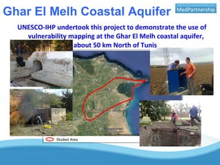
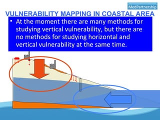
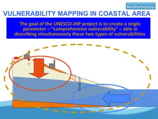
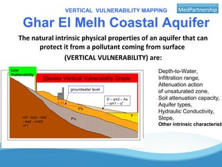
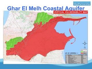
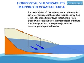
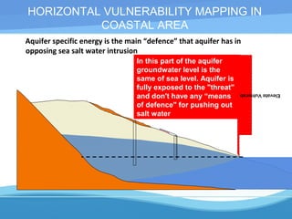
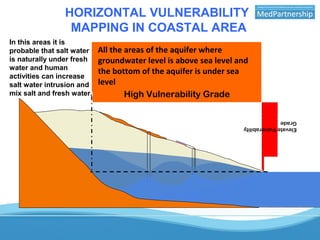
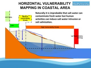
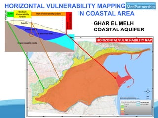
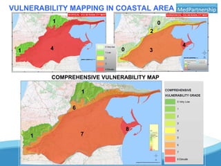
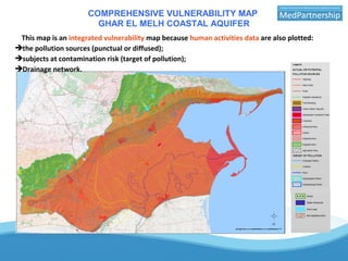
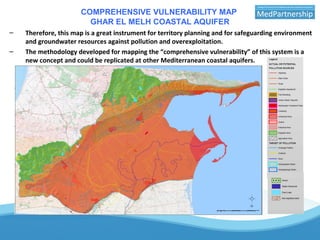
UNESCO-IHP vulnerability mapping
demonstration project at the Ghar El
Melh coastal aquifer in Tunisia
Dott. Salvatore Carrubba
Consultant Geologist
Ghar El Melh Coastal Aquifer
Studied Area
UNESCO-IHP undertook this project to demonstrate the use of
vulnerability mapping at the Ghar El Melh coastal aquifer,
about 50 km North of Tunis
VULNERABILITY MAPPING IN COASTAL AREA
In coastal area we must consider two components of the evaluation of
aquifer vulnerability:
•vertical vulnerability against vertical pollution from surface
•and horizontal vulnerability due to the salt water intrusion phenomena.
Sea salt water is heavier than fresh water and in coastal area, it, can
intrude itself into the aquifer flowing under the fresh water (of the
aquifer) in a delicate equilibrium of weights
• At the moment there are many methods for
studying vertical vulnerability, but there are
no methods for studying horizontal and
vertical vulnerability at the same time.
VULNERABILITY MAPPING IN COASTAL AREA
The goal of the UNESCO-IHP project is to create a single
parameter – “comprehensive vulnerability” – able in
describing simultaneously these two types of vulnerabilities
Simplifying the hydro geological model, the main aquifer is constituted by the “Grès de
Porto Farina” (Upper Pliocene) that are sands and calcarenite, each other mixed.
This aquifer is a multilayer aquifer and this aquifer is in hydraulic connection with
the "younger" permeable deposits and sea water.
On the other hand the “Marnes de Raf Raf” (Pliocene) are impermeable clays
rocks and constitute the bed of the aquifer.
m3 - mc2 - mb2
- ma2 - mab2
m'1
P'a
P'b
a
D – qm2 – Aa
– qm1 – q"
SCHEMATIC HYDRO GEOLOGICAL MODEL
groundwater level
Ghar El Melh Coastal Aquifer
VULNERABILITY MAPPING IN COASTAL AREA
• Keeping in mind that vulnerability is an intrinsic
characteristic of the aquifer in defending itself from
an external threat that can be a pollutant or a
contaminant.
• we must look for the intrinsic characteristics of the
aquifer that can be able in opposing to a pollutant
from surface or to a contaminant like salt water
intrusion.
VERTICAL VULNERABILITY MAPPING
Ghar El Melh Coastal Aquifer
m3 - mc2 - mb2
- ma2 - mab2
m'1
P'a
P'b
a
D – qm2 – Aa
– qm1 – q"
SCHEMATIC HYDRO GEOLOGICAL MODEL
groundwater level
Elevate Vertical Vulnerability Grade
Low
Vulnerability
The natural intrinsic physical properties of an aquifer that can
protect it from a pollutant coming from surface
(VERTICAL VULNERABILITY) are:
Depth-to-Water,
Infiltration range,
Attenuation action
of unsaturated zone,
Soil attenuation capacity,
Aquifer types,
Hydraulic Conductivity,
Slope,
Other intrinsic characteristi
Ghar El Melh Coastal Aquifer
HORIZONTAL VULNERABILITY
MAPPING IN COASTAL AREA
The main “defence” that aquifer has in opposing sea
salt water intrusion is the aquifer specific energy that
is linked to groundwater level. In fact, more fresh
groundwater level is higher above sea level, and more
able the aquifer will be in opposing salt water
intrusion pushing out salt water
HORIZONTAL VULNERABILITY MAPPING IN
COASTAL AREA
Aquifer specific energy is the main “defence” that aquifer has in
opposing sea salt water intrusion
ElevateVulnerabilityGrade.
In this part of the aquifer
groundwater level is the
same of sea level. Aquifer is
fully exposed to the "threat"
and don't have any “means
of defence" for pushing out
salt water
HORIZONTAL VULNERABILITY
MAPPING IN COASTAL AREA
All the areas of the aquifer where
groundwater level is above sea level and
the bottom of the aquifer is under sea
level
ElevateVulnerability
Grade
High Vulnerability Grade
In this areas it is
probable that salt water
is naturally under fresh
water and human
activities can increase
salt water intrusion and
mix salt and fresh water.
HORIZONTAL VULNERABILITY
MAPPING IN COASTAL AREA
Naturally it is improbable that salt water can
contaminate fresh water but human
activities can induce salt water intrusion or
soil salinization.
Elevate
VulnerabilityGr.
High Vulnerability Grade
Medium
Vulnerability
Grade
Low
VeryLow
HORIZONTAL VULNERABILITY MAPPING
IN COASTAL AREA
GHAR EL MELH
COASTAL AQUIFER
VULNERABILITY MAPPING IN COASTAL AREA
1
1
4 0
0
2
3
4
7
6
1
1
8
COMPREHENSIVE VULNERABILITY MAP
GHAR EL MELH COASTAL AQUIFER
This map is an integrated vulnerability map because human activities data are also plotted:
the pollution sources (punctual or diffused);
subjects at contamination risk (target of pollution);
Drainage network.
COMPREHENSIVE VULNERABILITY MAP
GHAR EL MELH COASTAL AQUIFER
– Therefore, this map is a great instrument for territory planning and for safeguarding environment
and groundwater resources against pollution and overexploitation.
– The methodology developed for mapping the “comprehensive vulnerability” of this system is a
new concept and could be replicated at other Mediterranean coastal aquifers.
Thank you for your attention
Merci pour votre attention
‫لتنتباهكم‬ ‫ا‬ً ‫شكر‬

Carrubba presentation athene_

  • 1.
    UNESCO-IHP vulnerability mapping demonstrationproject at the Ghar El Melh coastal aquifer in Tunisia Dott. Salvatore Carrubba Consultant Geologist
  • 2.
    Ghar El MelhCoastal Aquifer Studied Area UNESCO-IHP undertook this project to demonstrate the use of vulnerability mapping at the Ghar El Melh coastal aquifer, about 50 km North of Tunis
  • 3.
    VULNERABILITY MAPPING INCOASTAL AREA In coastal area we must consider two components of the evaluation of aquifer vulnerability: •vertical vulnerability against vertical pollution from surface •and horizontal vulnerability due to the salt water intrusion phenomena. Sea salt water is heavier than fresh water and in coastal area, it, can intrude itself into the aquifer flowing under the fresh water (of the aquifer) in a delicate equilibrium of weights • At the moment there are many methods for studying vertical vulnerability, but there are no methods for studying horizontal and vertical vulnerability at the same time.
  • 4.
    VULNERABILITY MAPPING INCOASTAL AREA The goal of the UNESCO-IHP project is to create a single parameter – “comprehensive vulnerability” – able in describing simultaneously these two types of vulnerabilities
  • 5.
    Simplifying the hydrogeological model, the main aquifer is constituted by the “Grès de Porto Farina” (Upper Pliocene) that are sands and calcarenite, each other mixed. This aquifer is a multilayer aquifer and this aquifer is in hydraulic connection with the "younger" permeable deposits and sea water. On the other hand the “Marnes de Raf Raf” (Pliocene) are impermeable clays rocks and constitute the bed of the aquifer. m3 - mc2 - mb2 - ma2 - mab2 m'1 P'a P'b a D – qm2 – Aa – qm1 – q" SCHEMATIC HYDRO GEOLOGICAL MODEL groundwater level Ghar El Melh Coastal Aquifer
  • 6.
    VULNERABILITY MAPPING INCOASTAL AREA • Keeping in mind that vulnerability is an intrinsic characteristic of the aquifer in defending itself from an external threat that can be a pollutant or a contaminant. • we must look for the intrinsic characteristics of the aquifer that can be able in opposing to a pollutant from surface or to a contaminant like salt water intrusion.
  • 7.
    VERTICAL VULNERABILITY MAPPING GharEl Melh Coastal Aquifer m3 - mc2 - mb2 - ma2 - mab2 m'1 P'a P'b a D – qm2 – Aa – qm1 – q" SCHEMATIC HYDRO GEOLOGICAL MODEL groundwater level Elevate Vertical Vulnerability Grade Low Vulnerability The natural intrinsic physical properties of an aquifer that can protect it from a pollutant coming from surface (VERTICAL VULNERABILITY) are: Depth-to-Water, Infiltration range, Attenuation action of unsaturated zone, Soil attenuation capacity, Aquifer types, Hydraulic Conductivity, Slope, Other intrinsic characteristi
  • 8.
    Ghar El MelhCoastal Aquifer
  • 9.
    HORIZONTAL VULNERABILITY MAPPING INCOASTAL AREA The main “defence” that aquifer has in opposing sea salt water intrusion is the aquifer specific energy that is linked to groundwater level. In fact, more fresh groundwater level is higher above sea level, and more able the aquifer will be in opposing salt water intrusion pushing out salt water
  • 10.
    HORIZONTAL VULNERABILITY MAPPINGIN COASTAL AREA Aquifer specific energy is the main “defence” that aquifer has in opposing sea salt water intrusion ElevateVulnerabilityGrade. In this part of the aquifer groundwater level is the same of sea level. Aquifer is fully exposed to the "threat" and don't have any “means of defence" for pushing out salt water
  • 11.
    HORIZONTAL VULNERABILITY MAPPING INCOASTAL AREA All the areas of the aquifer where groundwater level is above sea level and the bottom of the aquifer is under sea level ElevateVulnerability Grade High Vulnerability Grade In this areas it is probable that salt water is naturally under fresh water and human activities can increase salt water intrusion and mix salt and fresh water.
  • 12.
    HORIZONTAL VULNERABILITY MAPPING INCOASTAL AREA Naturally it is improbable that salt water can contaminate fresh water but human activities can induce salt water intrusion or soil salinization. Elevate VulnerabilityGr. High Vulnerability Grade Medium Vulnerability Grade Low VeryLow
  • 13.
    HORIZONTAL VULNERABILITY MAPPING INCOASTAL AREA GHAR EL MELH COASTAL AQUIFER
  • 14.
    VULNERABILITY MAPPING INCOASTAL AREA 1 1 4 0 0 2 3 4 7 6 1 1 8 COMPREHENSIVE VULNERABILITY MAP
  • 15.
    COMPREHENSIVE VULNERABILITY MAP GHAREL MELH COASTAL AQUIFER This map is an integrated vulnerability map because human activities data are also plotted: the pollution sources (punctual or diffused); subjects at contamination risk (target of pollution); Drainage network.
  • 16.
    COMPREHENSIVE VULNERABILITY MAP GHAREL MELH COASTAL AQUIFER – Therefore, this map is a great instrument for territory planning and for safeguarding environment and groundwater resources against pollution and overexploitation. – The methodology developed for mapping the “comprehensive vulnerability” of this system is a new concept and could be replicated at other Mediterranean coastal aquifers.
  • 17.
    Thank you foryour attention Merci pour votre attention ‫لتنتباهكم‬ ‫ا‬ً ‫شكر‬