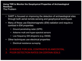
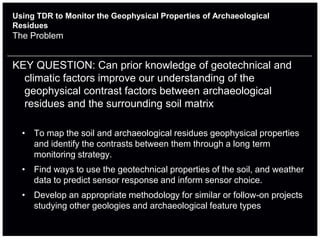
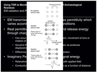
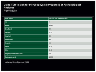
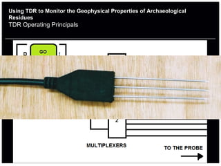
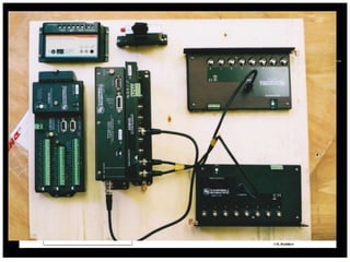
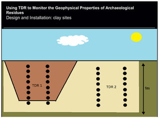
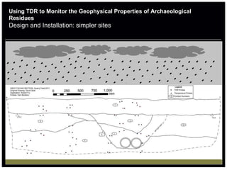
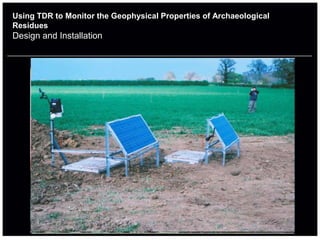
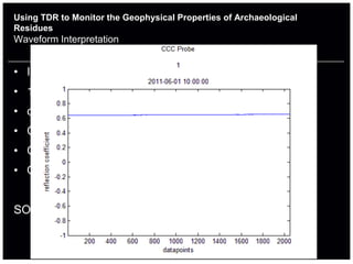
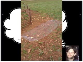
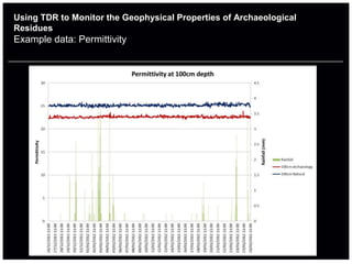
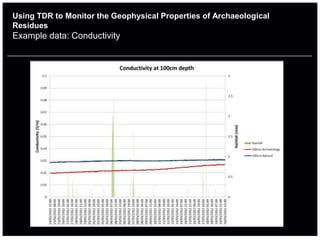
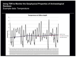
Using Time Domain Reflectometry (TDR) to
         Monitor the Geophysical Properties of
               Archaeological Residues


       Dan Boddice, Laura Pring, Dr. Nicole Metje, Dr. David Chapman


School of Civil Engineering
College of Engineering and Physical Sciences
Using TDR to Monitor the Geophysical Properties of Archaeological
Residues
The Problem


  • DART is focused on improving the detection of archaeological sites
    through both aerial remote sensing and geophysical techniques
  • Many of these use Electromagnetic (EM) radiation and require a
    contrast in EM properties
       • Ground penetrating radar (GPR)
       • Airborne multi and hyper-spectral sensors
       • Low frequency EM slingrams (e.g. EM38)
  • Other techniques use electrical properties
       • Electrical resistance surveying


  1. EVIDENCE FOR SOIL CONTRASTS IS ANECDOTAL
  2. POOR DETECTION RATES ON CERTAIN SOILS
Using TDR to Monitor the Geophysical Properties of Archaeological
Residues
The Problem


KEY QUESTION: Can prior knowledge of geotechnical and
  climatic factors improve our understanding of the
  geophysical contrast factors between archaeological
  residues and the surrounding soil matrix

  • To map the soil and archaeological residues geophysical properties
    and identify the contrasts between them through a long term
    monitoring strategy.
  • Find ways to use the geotechnical properties of the soil, and weather
    data to predict sensor response and inform sensor choice.
  • Develop an appropriate methodology for similar or follow-on projects
    studying other geologies and archaeological feature types
Using TDR to Monitor the Geophysical Properties of Archaeological
Residues
EM radiation and Permittivity Basics


• EM transmission is governed by complex permittivity which
  varies according to changing ground conditions
• Real permittivity is the ability to store and release energy
  through charge separation
       • Can occur due to separation of charges in atom, movement of ions or
         rotation of molecules in line with applied field
       • Governs the speed of EM radiation propagation as produces
         displacement electrical field
       • Difference in layers will determine size of reflection

• Imaginary Permittivity causes loss of signal energy
       • Relaxation mechanisms – lag in polarisation with applied field
       • Conductivity - causes the energy to attenuate as a function of distance
Using TDR to Monitor the Geophysical Properties of Archaeological
Residues
Permittivity

 SOIL TYPE                            DIELECTRIC PERMITTIVITY

 Air                                  1

 Water                                80-81

 Dry Sand                             3-5

 Dry Silt                             3-30

 Asphalt                              3-5

 Limestone                            4-8

 Granite                              4-6

 Shale                                5-15

 Clay                                 5-40

 Organic rich surface soil            12

 Saturated sand                       20-30


 Adapted from Conyers 2004
Using TDR to Monitor the Geophysical Properties of Archaeological
Residues
TDR Operating Principals
Using TDR to Monitor the Geophysical Properties of Archaeological
Residues
Design and Installation


Requirements
• Needs to take hourly readings of permittivity, conductivity
  and temperature
• Needs probes both in and out of archaeological feature and
  at different depths
• Needs constant power supply
• Needs some kind of communication
Using TDR to Monitor the Geophysical Properties of Archaeological
Residues
Design and Installation
Using TDR to Monitor the Geophysical Properties of Archaeological
Residues
Design and Installation: clay sites
Using TDR to Monitor the Geophysical Properties of Archaeological
Residues
Design and Installation: simpler sites
Using TDR to Monitor the Geophysical Properties of Archaeological
Residues
Design and Installation
Using TDR to Monitor the Geophysical Properties of Archaeological
Residues
Waveform Interpretation


• Identifying start and end reflection points takes time
• 16 permittivity per hour
• c.11520 per station per month
• Currently 6 stations –too many to do this manually!
• Conductivity data is simpler
• Quantity is the same as for permittivity


SOLUTION: Script needed
Using TDR to Monitor the Geophysical Properties of Archaeological
Residues
Other Challenges Since Installation


• Loggers behaving erratically
       • Skipped readings and scans
       • Unexplained stopping
       • Solved by slowing the scan rate and switching CF card brand
• Animal Damage
       • Weather Station cables eaten
              http://free-extras.com/images/elmer_fudd-5189.htm

       • Probes re-excavated
• Telemetry system will reduce future loss of data
Using TDR to Monitor the Geophysical Properties of Archaeological
Residues
Example data: Permittivity
Using TDR to Monitor the Geophysical Properties of Archaeological
Residues
Example data: Conductivity
Using TDR to Monitor the Geophysical Properties of Archaeological
Residues
Example data: Temperature
Using TDR to Monitor the Geophysical Properties of Archaeological
Residues
The future?


• Complete geotechnical analysis on soils from the lab to
  categorise them
• Create a link between permittivity, moisture content and
  bulk density using the TDR on prepared samples in the lab
• Analyse frequency dependence of soils in different states in
  the lab
• Continue to analyse data flow using statistical tests and
  time delay correlation
Progress Update
Acknowledgments


                   The Rest of the DART Project
 • Dave Stott , Dr. Anthony Beck and Dr. Anthony Cohn (University of
   Leeds)
 • Rob Fry and Dr. Chris Gaffney (University of Bradford)
 • Dr. Keith Wilkinson (University of Winchester)
 • The other stakeholders and academic consultants
                                  Also
 • Giulio Curioni and Andrew Foo (Mapping the Underworld)

Caa2012 dan boddice

  • 1.
    Using Time DomainReflectometry (TDR) to Monitor the Geophysical Properties of Archaeological Residues Dan Boddice, Laura Pring, Dr. Nicole Metje, Dr. David Chapman School of Civil Engineering College of Engineering and Physical Sciences
  • 2.
    Using TDR toMonitor the Geophysical Properties of Archaeological Residues The Problem • DART is focused on improving the detection of archaeological sites through both aerial remote sensing and geophysical techniques • Many of these use Electromagnetic (EM) radiation and require a contrast in EM properties • Ground penetrating radar (GPR) • Airborne multi and hyper-spectral sensors • Low frequency EM slingrams (e.g. EM38) • Other techniques use electrical properties • Electrical resistance surveying 1. EVIDENCE FOR SOIL CONTRASTS IS ANECDOTAL 2. POOR DETECTION RATES ON CERTAIN SOILS
  • 3.
    Using TDR toMonitor the Geophysical Properties of Archaeological Residues The Problem KEY QUESTION: Can prior knowledge of geotechnical and climatic factors improve our understanding of the geophysical contrast factors between archaeological residues and the surrounding soil matrix • To map the soil and archaeological residues geophysical properties and identify the contrasts between them through a long term monitoring strategy. • Find ways to use the geotechnical properties of the soil, and weather data to predict sensor response and inform sensor choice. • Develop an appropriate methodology for similar or follow-on projects studying other geologies and archaeological feature types
  • 4.
    Using TDR toMonitor the Geophysical Properties of Archaeological Residues EM radiation and Permittivity Basics • EM transmission is governed by complex permittivity which varies according to changing ground conditions • Real permittivity is the ability to store and release energy through charge separation • Can occur due to separation of charges in atom, movement of ions or rotation of molecules in line with applied field • Governs the speed of EM radiation propagation as produces displacement electrical field • Difference in layers will determine size of reflection • Imaginary Permittivity causes loss of signal energy • Relaxation mechanisms – lag in polarisation with applied field • Conductivity - causes the energy to attenuate as a function of distance
  • 5.
    Using TDR toMonitor the Geophysical Properties of Archaeological Residues Permittivity SOIL TYPE DIELECTRIC PERMITTIVITY Air 1 Water 80-81 Dry Sand 3-5 Dry Silt 3-30 Asphalt 3-5 Limestone 4-8 Granite 4-6 Shale 5-15 Clay 5-40 Organic rich surface soil 12 Saturated sand 20-30 Adapted from Conyers 2004
  • 6.
    Using TDR toMonitor the Geophysical Properties of Archaeological Residues TDR Operating Principals
  • 7.
    Using TDR toMonitor the Geophysical Properties of Archaeological Residues Design and Installation Requirements • Needs to take hourly readings of permittivity, conductivity and temperature • Needs probes both in and out of archaeological feature and at different depths • Needs constant power supply • Needs some kind of communication
  • 8.
    Using TDR toMonitor the Geophysical Properties of Archaeological Residues Design and Installation
  • 9.
    Using TDR toMonitor the Geophysical Properties of Archaeological Residues Design and Installation: clay sites
  • 10.
    Using TDR toMonitor the Geophysical Properties of Archaeological Residues Design and Installation: simpler sites
  • 11.
    Using TDR toMonitor the Geophysical Properties of Archaeological Residues Design and Installation
  • 12.
    Using TDR toMonitor the Geophysical Properties of Archaeological Residues Waveform Interpretation • Identifying start and end reflection points takes time • 16 permittivity per hour • c.11520 per station per month • Currently 6 stations –too many to do this manually! • Conductivity data is simpler • Quantity is the same as for permittivity SOLUTION: Script needed
  • 13.
    Using TDR toMonitor the Geophysical Properties of Archaeological Residues Other Challenges Since Installation • Loggers behaving erratically • Skipped readings and scans • Unexplained stopping • Solved by slowing the scan rate and switching CF card brand • Animal Damage • Weather Station cables eaten http://free-extras.com/images/elmer_fudd-5189.htm • Probes re-excavated • Telemetry system will reduce future loss of data
  • 14.
    Using TDR toMonitor the Geophysical Properties of Archaeological Residues Example data: Permittivity
  • 15.
    Using TDR toMonitor the Geophysical Properties of Archaeological Residues Example data: Conductivity
  • 16.
    Using TDR toMonitor the Geophysical Properties of Archaeological Residues Example data: Temperature
  • 17.
    Using TDR toMonitor the Geophysical Properties of Archaeological Residues The future? • Complete geotechnical analysis on soils from the lab to categorise them • Create a link between permittivity, moisture content and bulk density using the TDR on prepared samples in the lab • Analyse frequency dependence of soils in different states in the lab • Continue to analyse data flow using statistical tests and time delay correlation
  • 18.
    Progress Update Acknowledgments The Rest of the DART Project • Dave Stott , Dr. Anthony Beck and Dr. Anthony Cohn (University of Leeds) • Rob Fry and Dr. Chris Gaffney (University of Bradford) • Dr. Keith Wilkinson (University of Winchester) • The other stakeholders and academic consultants Also • Giulio Curioni and Andrew Foo (Mapping the Underworld)