After emerging from the resources wilderness thanks to its world-class geology and industry-friendly government policies, South Australia is now a leader in Australian mining and hydrocarbon developments over the last decade.
In little more than a decade the State has gone from four operating mines to more than 20 and is rated Australia’s second most popular exploration destination.
With a comprehensive review of the Mining Act under way, the State’s attractiveness as a place for resources and energy investment is expected to be strengthened.
South Australia is now a leader in the exploration for next generation energy sources with companies such as Santos and BP leading the charge, while initiatives such as the Government’s Copper Strategy – designed to treble annual copper production to 1 mtpa – is set to establish the State as one of the world’s premier producers of the red metal.
In the energy space, uranium and nuclear energy is another area of keen interest, with the South Australian Government initiating a Royal Commission into Participation in the Nuclear Fuel Cycle in 2016.
The State has become synonymous with innovation, cutting-edge development and a remarkable rate of discovery. From uranium prospects, to geothermal energy and the buoyant hydrocarbons sector, South Australia is now a leader in the exploration for next generation energy sources.
With full support from the Department of State Development, the South Australian Resources and Energy Investment Conference will continue to showcase this burgeoning sector in 2017. From copper plays in the Gawler Craton, to iron ore and graphite developments on the Eyre Peninsula and the emergence of the State as a new hydrocarbon frontier, South Australia’s resources potential is at last being fully recognised.
The conference will feature the success stories and emerging players in the State from both minerals and oil and gas and will also tackle thorny industry issues such as infrastructure, corporate social responsibility and the future of the Woomera Prohibited Area.
Velocity analysis and depth conversion in the offshre kaboudia permitGuizani Aymen
Accurate depth conversion is vital to map depth and thickness of subsurface layers interpreted from seismic reflection images and for structural model building, but depth conversion requires good quality seismic velocity information. The number and distribution of wells with velocity information in the Kaboudia permit is poor, in contrast, a 3D post-stack seismic reflection data covers the area of interest and providing a good distribution of stacking velocities.
Seismic stacking velocities are an outcome of seismic processing and are thus not a direct measurement of the speed of sound in rocks. To improve the quality of the depth conversion workflow in this area characterized by a complex geological environment a methodology is suggested to calibrate stacking velocities against borehole velocity measurements. This would allow the widespread stacking velocities to be used to create a more constrained velocity model of the interpreted layers in the Kaboudia permit.
The methodology consist of computing calibration coefficient resulting from comparing seismic velocities and wells data then Multiply depths derived from stacking velocities by calibration coefficient mapped with different options of gridding. the robustness of this process is assessed by putting the resulting converted surfaces in contrast with other simple depth conversion workflows and by relative errors to wells and uncertainty analysis.
On December 20 Donald Trump called for a “federal strategy to ensure secure and reliable supplies of critical minerals.” The move came one day after the U.S. Geological Survey released the first comprehensive update on the subject since 1973, taking a thorough look—nearly 900-pages thorough—at commodities vital to our neighbour’s, and ultimately the West’s, well-being.
Grading contractor uses automated grade control to guide construction of passive water treatment system for Pennsylvania acid mine drainage remediation project, Industrial WaterWorld magazine, by Don Talend, brand storytelling, content management and demand generation expert. Water engineering, construction, and geospatial technology industries
Research Inventy : International Journal of Engineering and Science is published by the group of young academic and industrial researchers with 12 Issues per year. It is an online as well as print version open access journal that provides rapid publication (monthly) of articles in all areas of the subject such as: civil, mechanical, chemical, electronic and computer engineering as well as production and information technology. The Journal welcomes the submission of manuscripts that meet the general criteria of significance and scientific excellence. Papers will be published by rapid process within 20 days after acceptance and peer review process takes only 7 days. All articles published in Research Inventy will be peer-reviewed.
Research poster - 2018 Battelle Conference on Remediation of Chlorinated Comp...Nick Jenshak
Co-Authored abstract and research poster that was accepted to the 2018 Battelle Conference on Remediation of Chlorinated and Recalcitrant Compounds under the title “Using Soil Gas Concentration Mapping to Predict Soil Vapor Extraction Radius of Influence Variances and Optimize Remedial System Design.”
EPA MEW Study Area TCE Source InvestigationSteve Williams
EPA TCE Source Investigation Findings
Middlefield-Ellis-Whisman (MEW)
Superfund Study Area
Mountain View and Moffett Field, CA
Former NAS Moffett Field
Restoration Advisory Board Meeting
February 12, 2015
Teresa Stephens, GIS Specialist, Paul Bechtel & Associates, Inc. and Andrew Weinberg, Geoscientist, Texas Water Development Board
Presented at the 2011 Texas GIS Forum
Orion Park Housing Area VOC Plume AssessmentSteve Williams
Presentation by the Army Environmental Command to the Moffett Field Restoration Advisory Board, November 20, 2014: Orion Park Housing Area Volatile Organic Compound Plume Assessment. Speaker: Matt Dayoc
As operators in the Permian Basin increasingly turn their attention towards unconventional plays including the Wolfcamp, Bone Spring, Spraberry and Cline, geologists, geophysicists and petrophysicists working in the region are finding themselves faced with a fresh set of challenges.
With key acreage positions now secured and many sweet spots already identified, geoscientists working in the Permian Basin's unconventional plays are now looking towards using geological & geophysical data to maximize well productivity & optimize drilling & completions strategies.
Organized in collaboration with leading Permian Basin E&Ps, the inaugural Permian Basin Geology & Geophysics Congress 2014 (July 15 - 16, Houston, Texas) will be the first E&P led technical forum specifically designed for geologists, geophysicist and petrophysicists working in unconventional plays in the Permian Basin.
Leading E&Ps in the Permian Basin will provide 20+ brand new case studies providing practical solutions from real life experience in incorporating geological and geophysical data into successful drilling and completions strategies that maximize well productivity.
Delineation of Hydrocarbon Bearing Reservoirs from Surface Seismic and Well L...IOSR Journals
Hydrocarbon reservoir has been delineated and their boundaries mapped using direct indicators from 3-D seismic and well log data from an oil field in Nembe creek, Niger Delta region. Well log signatures were employed to identify hydrocarbon bearing sands. Well to seismic correlation revealed that these reservoirs tied with direct hydrocarbon indicators on the seismic section. The results of the interpreted well logs revealed that the hydrocarbon interval in the area occurs between 6450ft to 6533ft for well A, 6449ft to 6537ft for well B and 6629ft to 6704ft for well C; which were delineated using the resistivity, water saturation and gamma ray logs. Cross plot analysis was carried out to validate the sensitivity of the rock attributes to reservoir saturation condition. Analysis of the extracted seismic attribute slices revealed HD5000 as hydrocarbon bearing reservoir.
The study of fine reservoir characterization base on high precision seismic i...iosrjce
According to the potential of fine adjustment in Daqing Oilfield in high water cut stage, this study
meet in dense well network condition more high precision reservoir description requirements. The study area of
reservoir II and III reservoir formation in Saertu oilfield, Daqing oil field is studied. Through the full
investigation of the ideas and methods of the reservoir characterization, this study tries to improve the seismic
attribute resolution by a variety of inversion methods, and thus a set of high accuracy seismic inversion and
prediction of underground real situation is formed. This study first analyzes the reliability of the well seismic
combined with the correlation analysis of the scientific rigorous seismic inversion data and the reservoir log
data. Then in the analysis of various factors to describe the influence of, and combined with the seismic
sedimentology, research ideas, based on high precision seismic inversion to prediction of reservoir sand body
fine then characterize. Has an important guiding significance, tapping the research results on the late stage of
oilfield development.
A presentation from Jared VanMeter from Range Resources showing maps and background information on the emerging Upper Devonian Shale formation--a layer of shale that sits a few hundred feet above the Marcellus Shale in the northeastern U.S. Range and several other drillers are now targeting the Upper Devonian, part of a "stacked play" strategy that includes drilling three layers in the same well: Upper Devonian, Marcellus and Utica.
Impact of A Paleochannel on Hydrogeochemistry of A Quaternary Aquifer: Case S...QUESTJOURNAL
ABSTRACT: This study investigated the influence of Wadi Lamhah paleochannel on hydrogeochemistry of the Quaternary aquifer in Umm Al Quwain area, United Arab Emirates (UAE). Results show that the groundwater temperature in water wells affected by Wadi Lamhah channel was 3 to 7°C less than the groundwater temperature in rest of the study area. Groundwater salinity in the channel-affected wells ranged from 803 to 5,407 mg/L and averaged 3,219 mg/L, while the groundwater salinity in rest of the study area was higher, reaching 11,643 mg/L in well 24, which suffered from salt-water intrusion from the sea. Except HCO3 - (329 mg/L), average concentrations of major ions in the channel-controlled wells were lower than their average concentrations in all wells within the study area. Average concentrations of detected trace elements B, Fe and Zn were lower in channel-affected wells than the rest of the study area. The high total hardness in channelaffected wells reflected the flux of Ca and Mg-rich recharge water moving into the aquifer through its southern boundary. The calculated SAR values indicated that the groundwater is good for irrigation along the course of Wadi Lamhah channel and harmful to plant and soil in the rest of the study area.
Study: Evaluation of Methane Sources in Groundwater in Northeastern PennsylvaniaMarcellus Drilling News
A study published in the May-June 2013 issue of Groundwater, a peer-reviewed scientific journal. The study highlights the results of data from 1,701 water wells in Susquehanna County, PA to determine whether or not nearby shale drilling causes an increase in the presence of methane in water wells. The study proves conclusively that water wells near shale drilling had no higher presence of methane than those not near any kind of drilling and that drilling in the Dimock area had nothing to do with methane in nearby water wells. It further proves that Susquehanna County, PA has a tremdendous amount of naturally ocurring methane near the surface.
Evidence of Geological Control on Reservoir Petrophysical Properties of “Beta...Premier Publishers
Geological controls on the reservoir petrophysical properties of “BETA Field” have been carried out using suites of wireline logs. Stratigraphic relationship among the reservoir sand bodies including their geometrical architectures, and their stacking patterns were also established. Exponential regression analysis of some of the petrophysical parameters were carried out to establish any relationship with depositional processes as well as depositional environments of the reservoir sand bodies in the field. The main factor controlling petrophysical properties and thickness for these reservoirs is the type of sandstone facies. The petrophysical evaluation of both reservoirs (K and Q) depicts porosity range from fair to very good across wells (i.e 11% to 25%). From the evaluated reservoirs porosity, there is no significant reduction of porosity with depth increase. The values obtained for the permeability of both reservoirs (K and Q) varied widely and inconsistent across the wells in the study field. The various depositional environments established in BETA field include fluvial, tidal channel, mouth bars, delta front, and the reservoir sands occurring in different depositional settings, resulting from different depositional processes, which had a wide range of petrophysical properties.
Similar to Bone Spring 2 porosity distribution in Lea Co New Mexico.pdf (20)
10. Conclusions
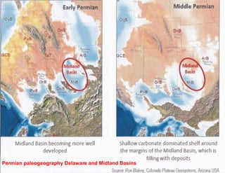
• Paleogeography studies indicate highlands to the N (ancestral Rockies), W
(Diablo platform), E (Central Basin Platform) and S (Marathons) served as
potential source areas for the Delaware Basin Bone Spring and Wolfcamp.
• Bone Spring 2 higher initial rates and higher estimated ultimate recoveries
correlate with thicker log porosity isopach areas above 8 percent porosity. Core
data supports higher core permeability with higher log porosity.
• Detailed log correlation and mapping of Bone Spring 2 log porosity defines the
production sweet spots for offset infill drilling.
• Bone Spring 2 porosity thick trends oriented from NE-SW indicate cross bedded
channel sand deposition sourced from structural highlands to the N, E and W.
• Porosity logs in pilot holes or older wells that tested deeper structures are
crucial for mapping the porosity thick trends within the Bone Spring 2 and
maximizing the Bone Spring 2 play economics.