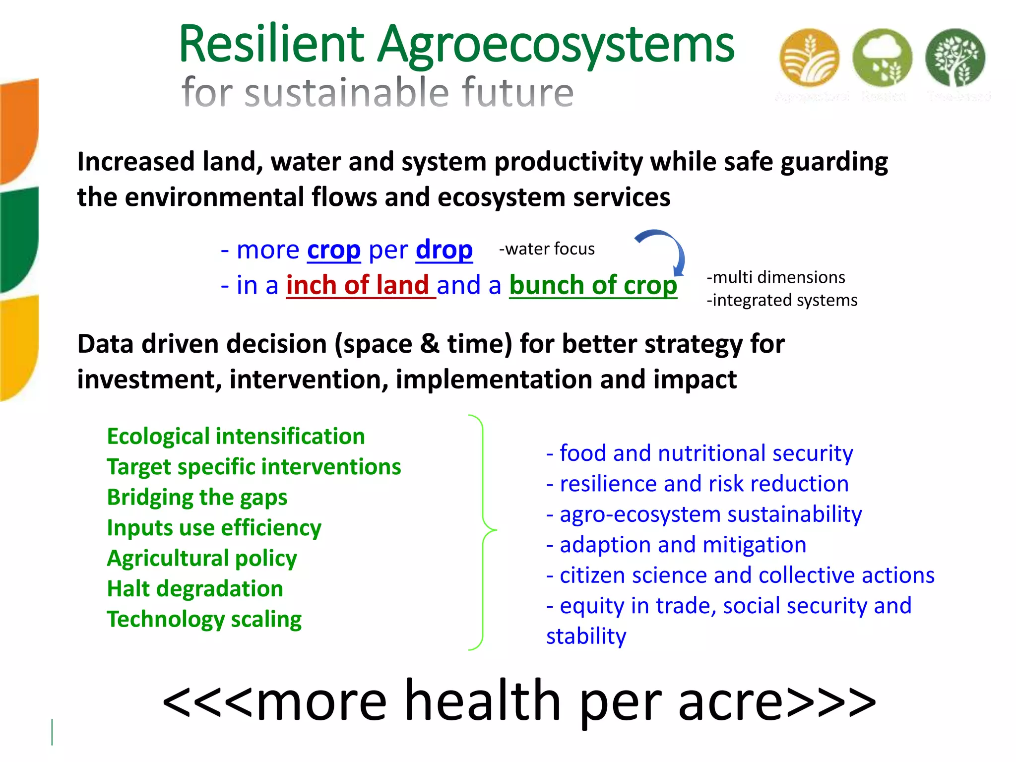
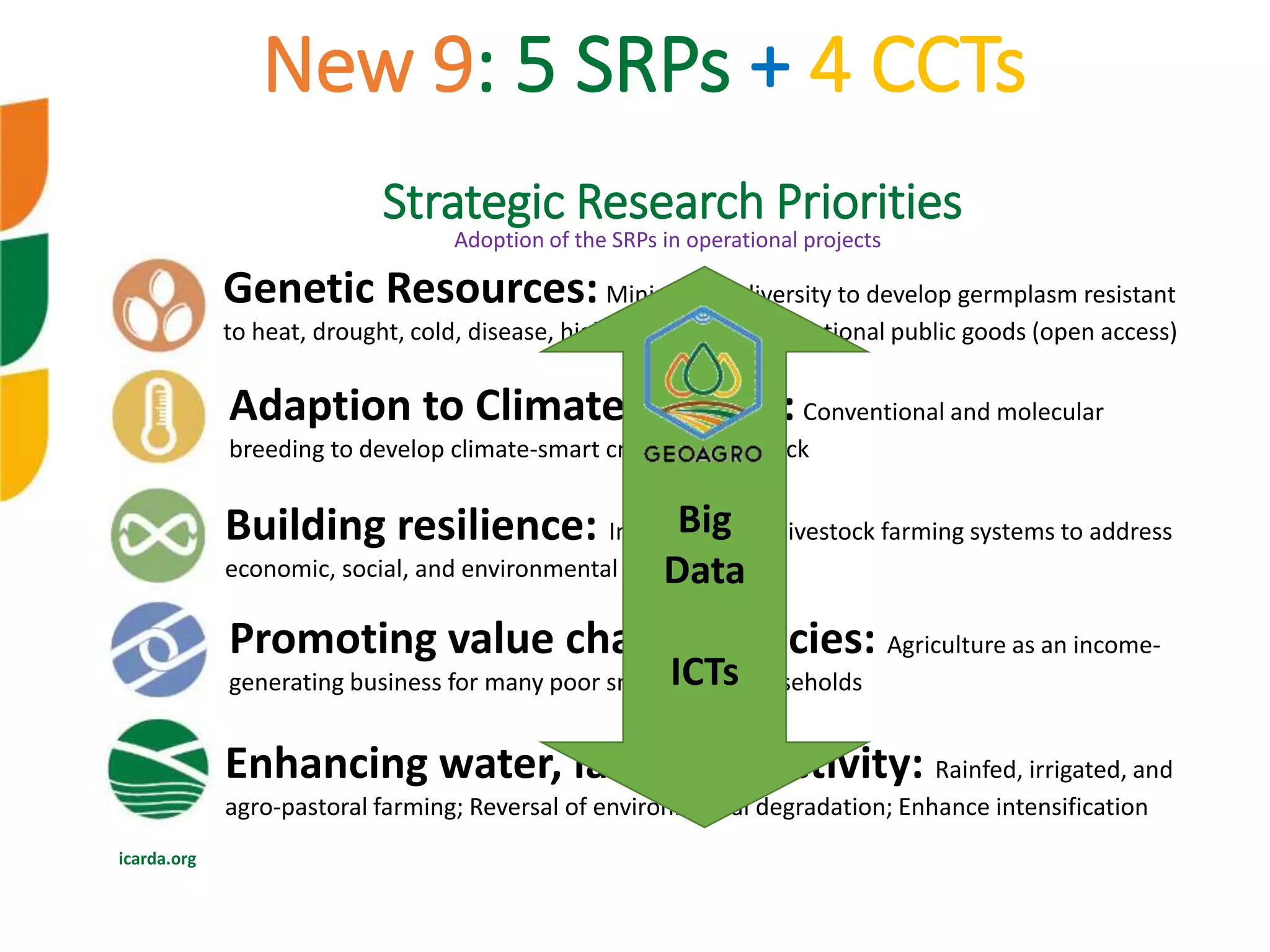
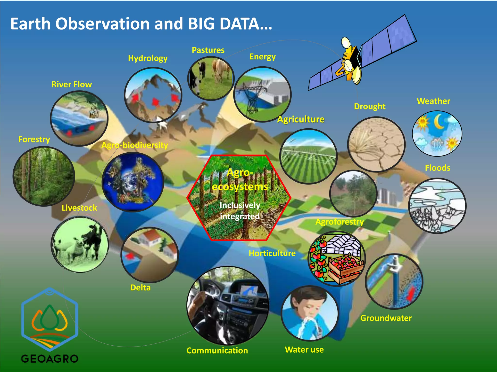
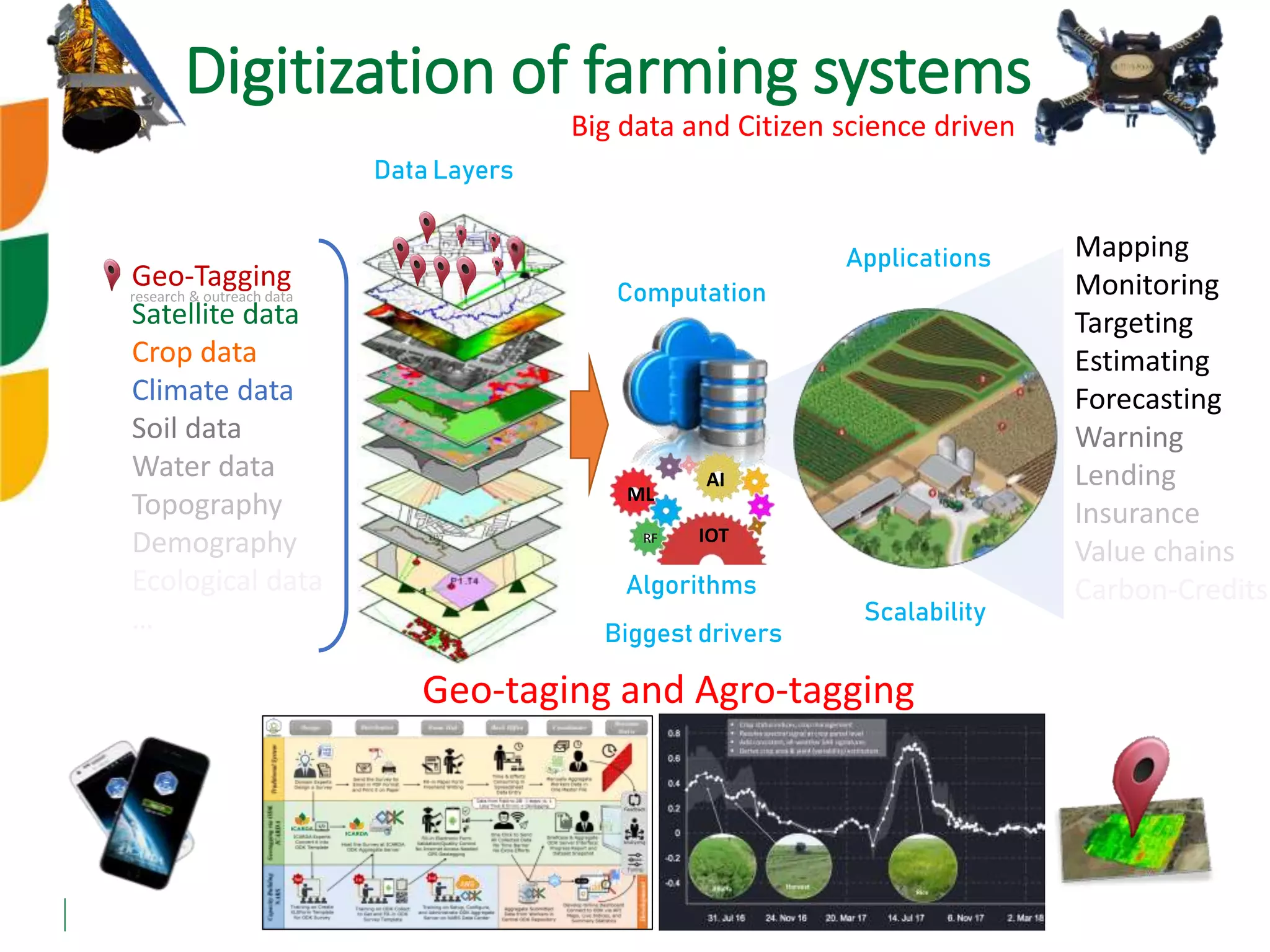
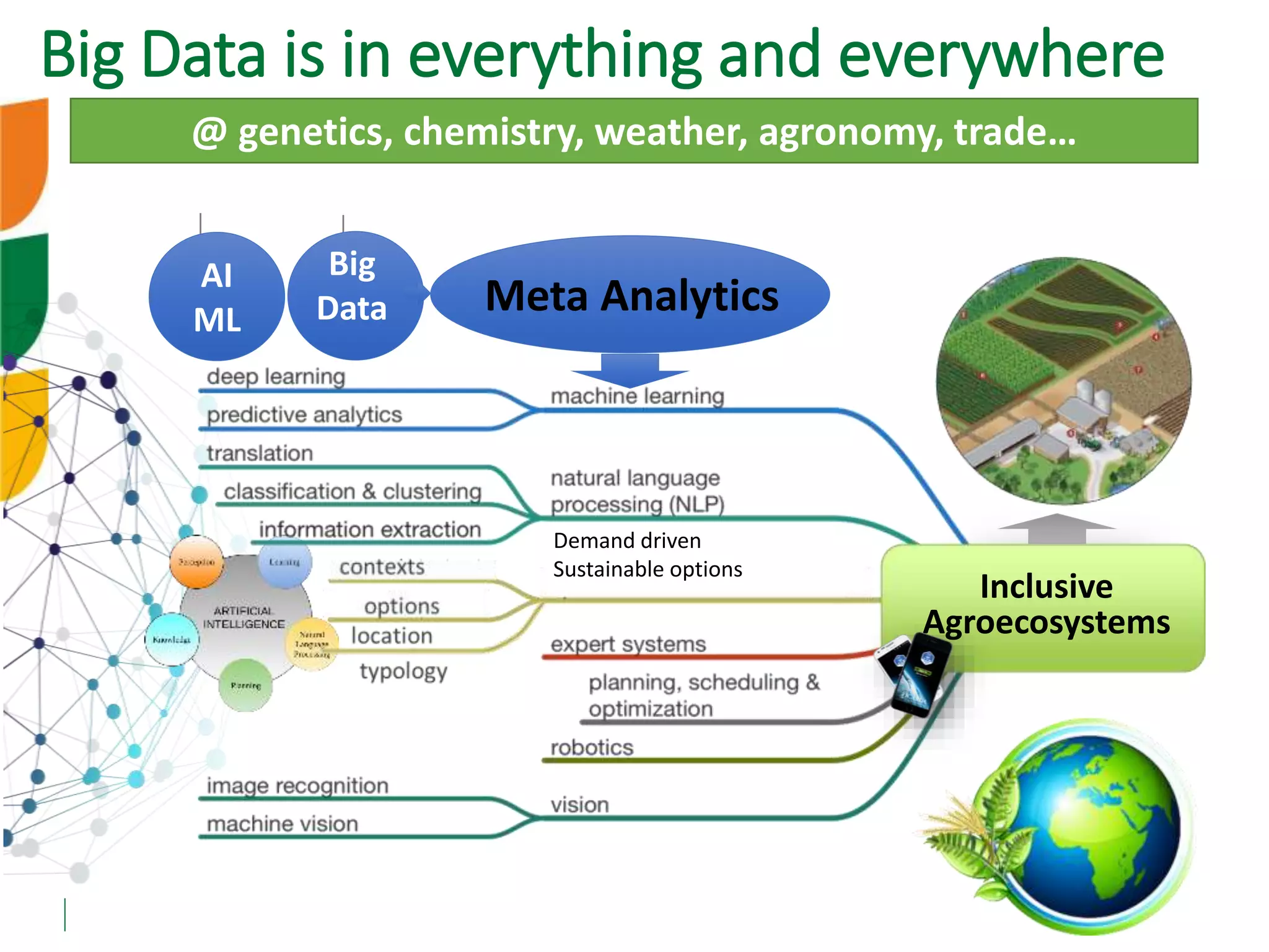
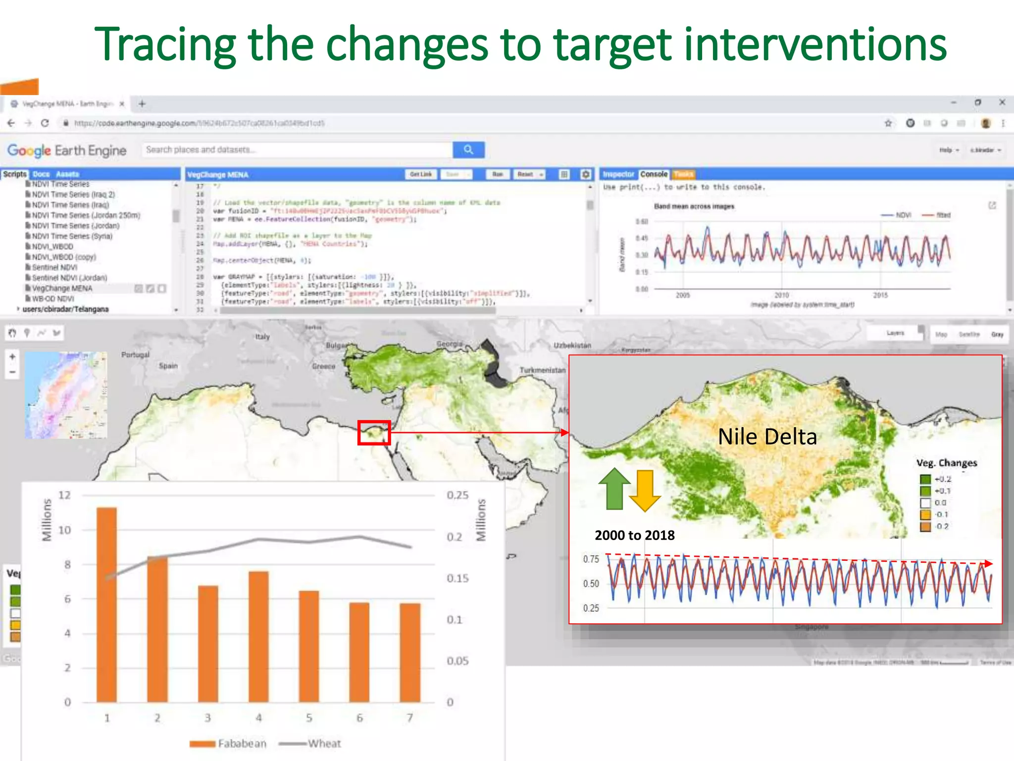
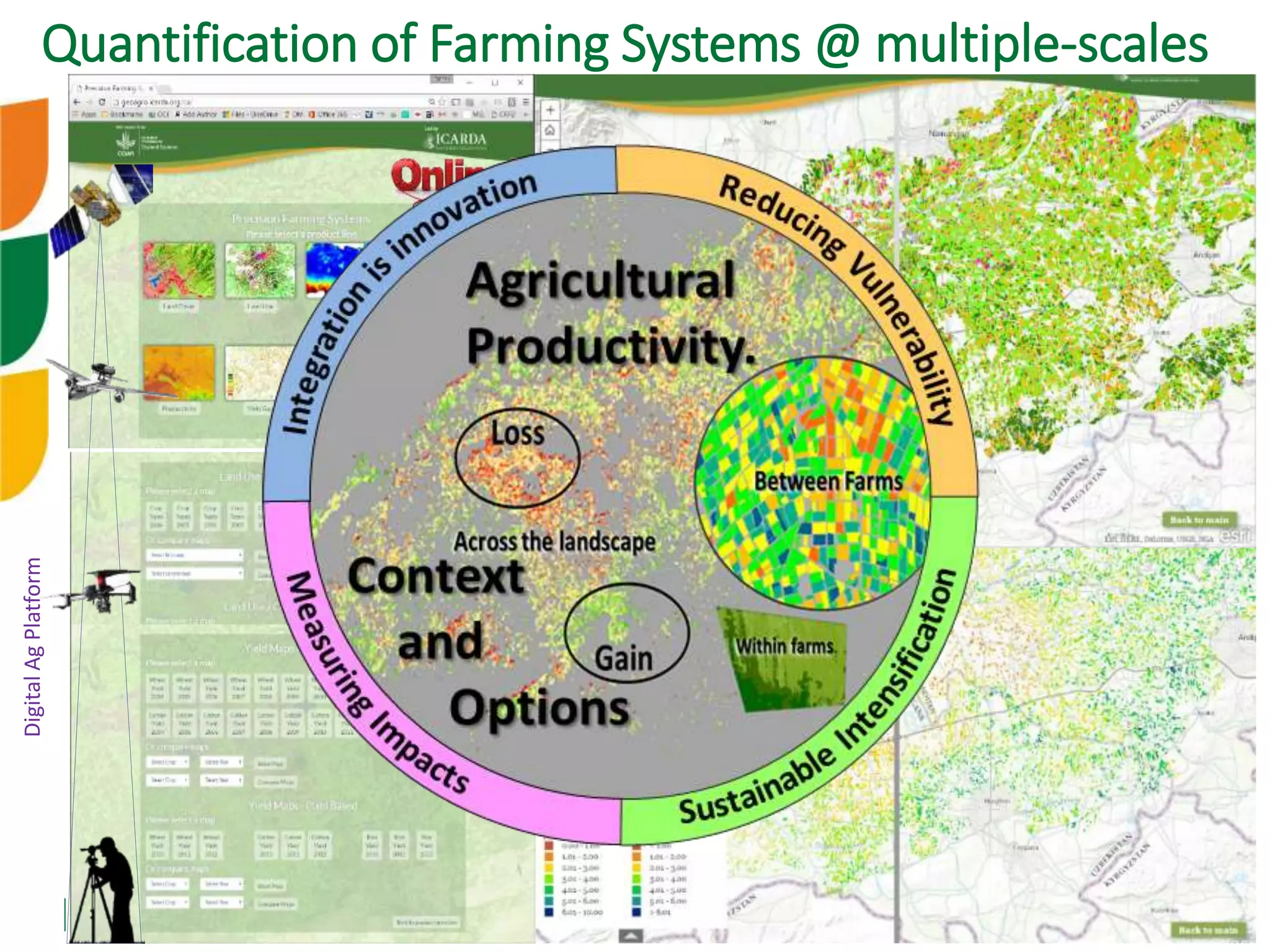
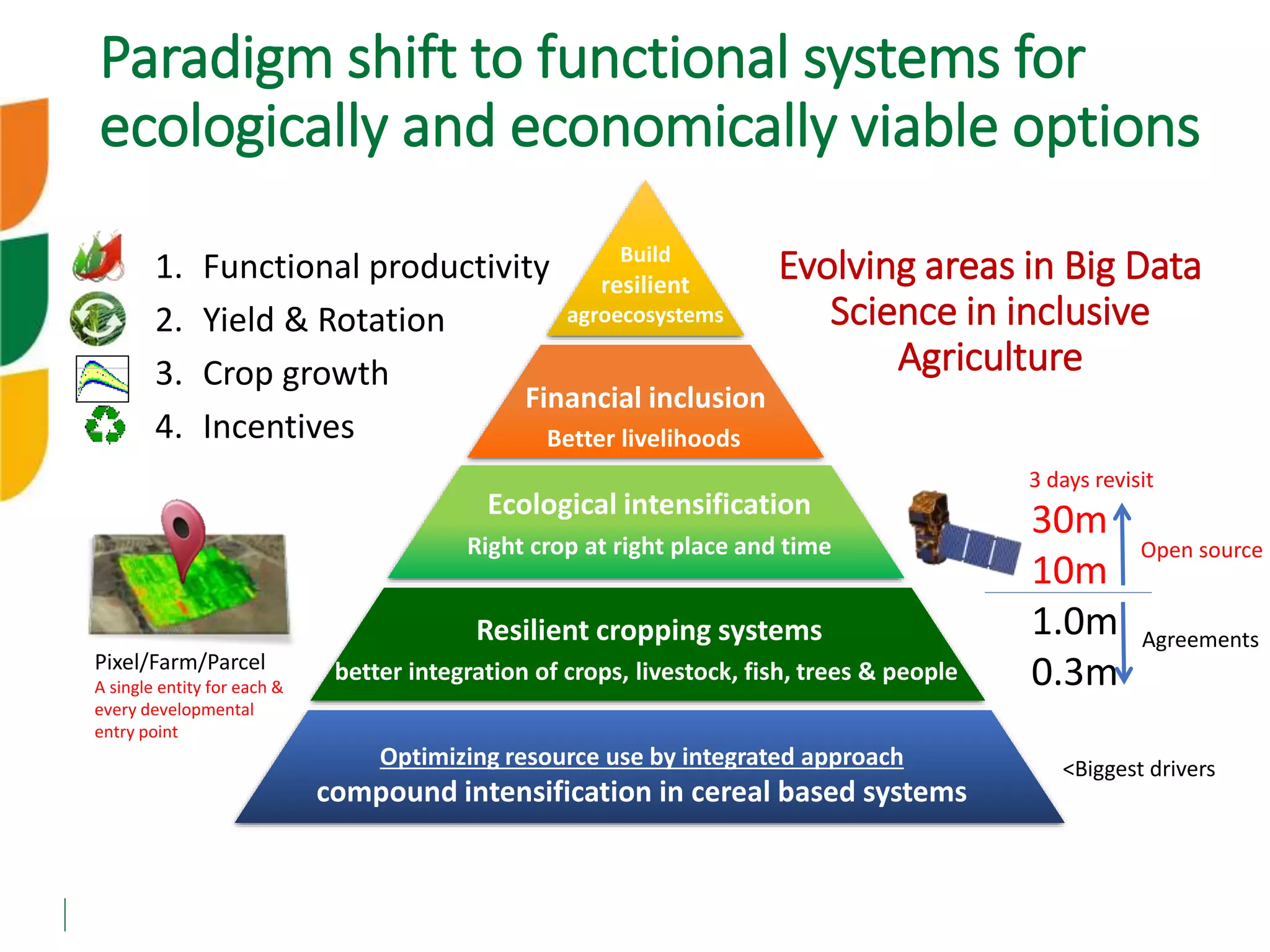
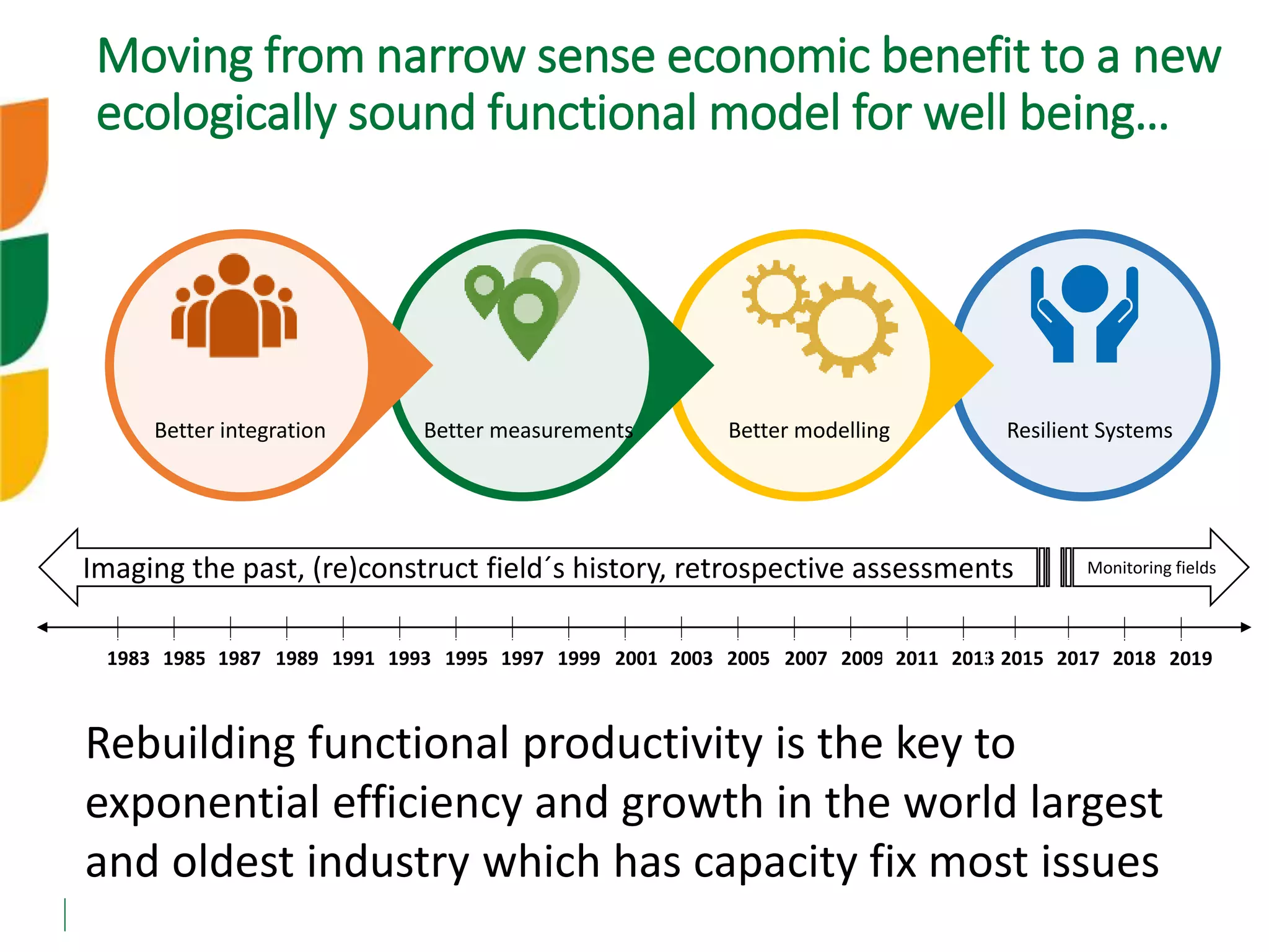
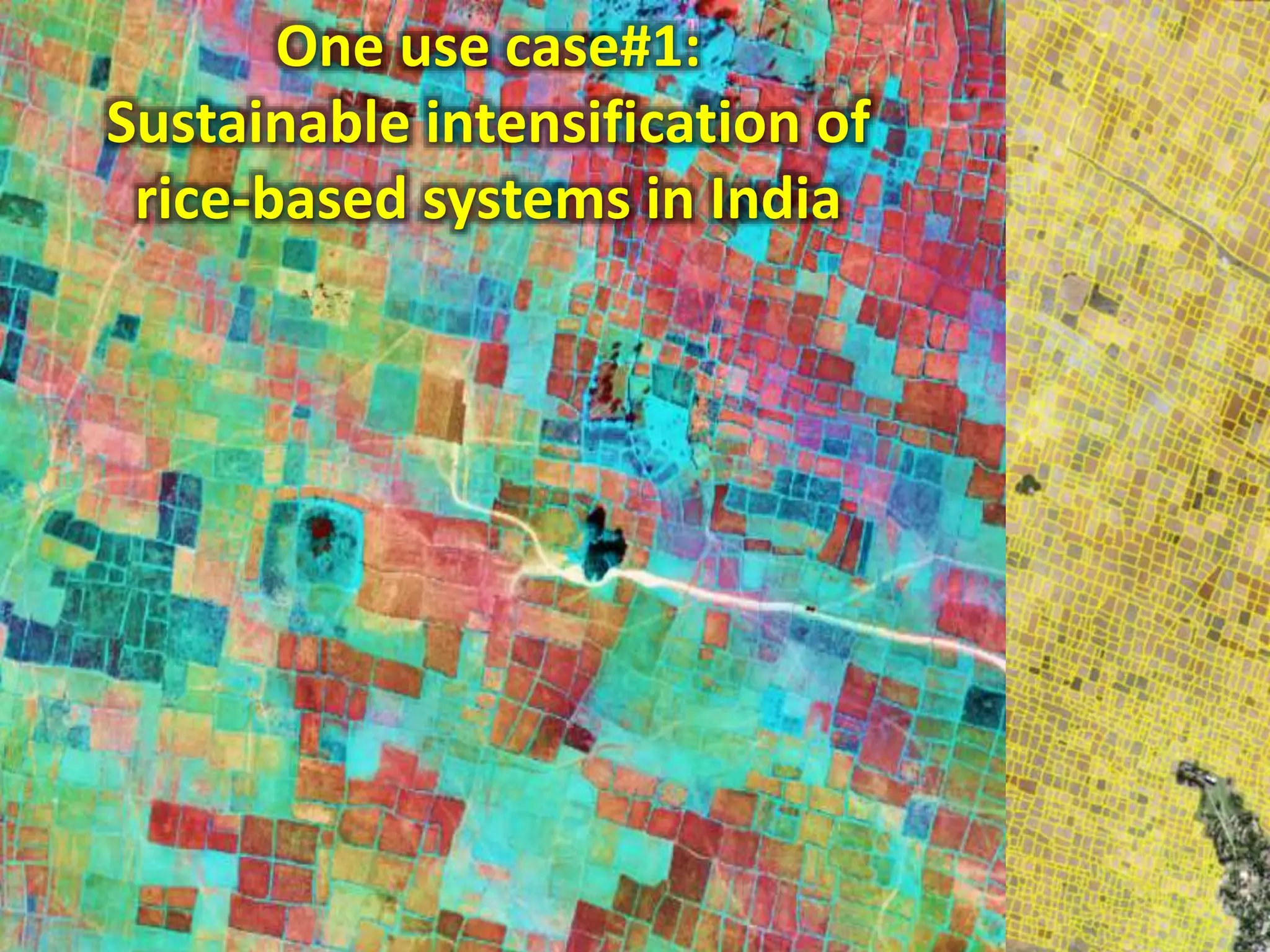
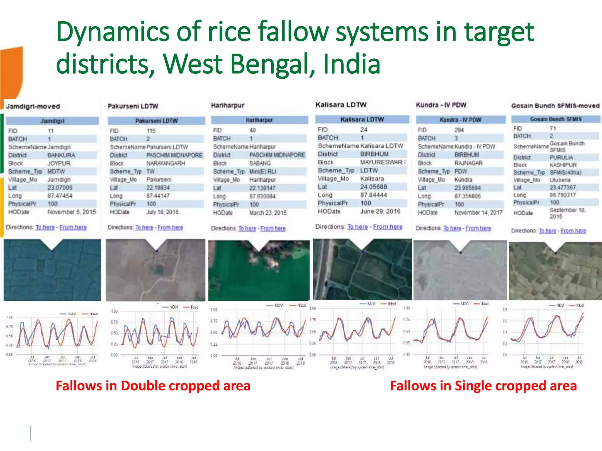
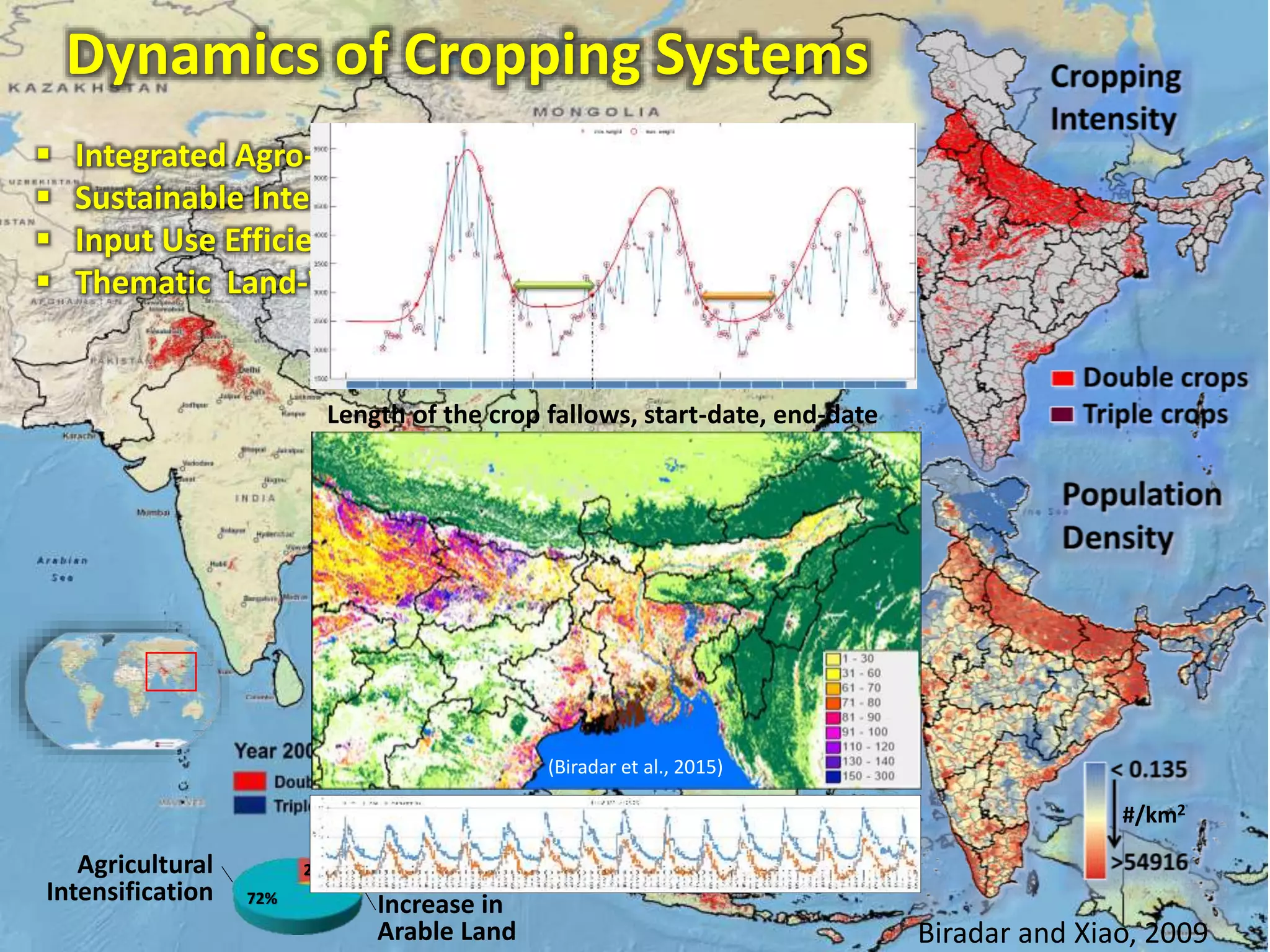
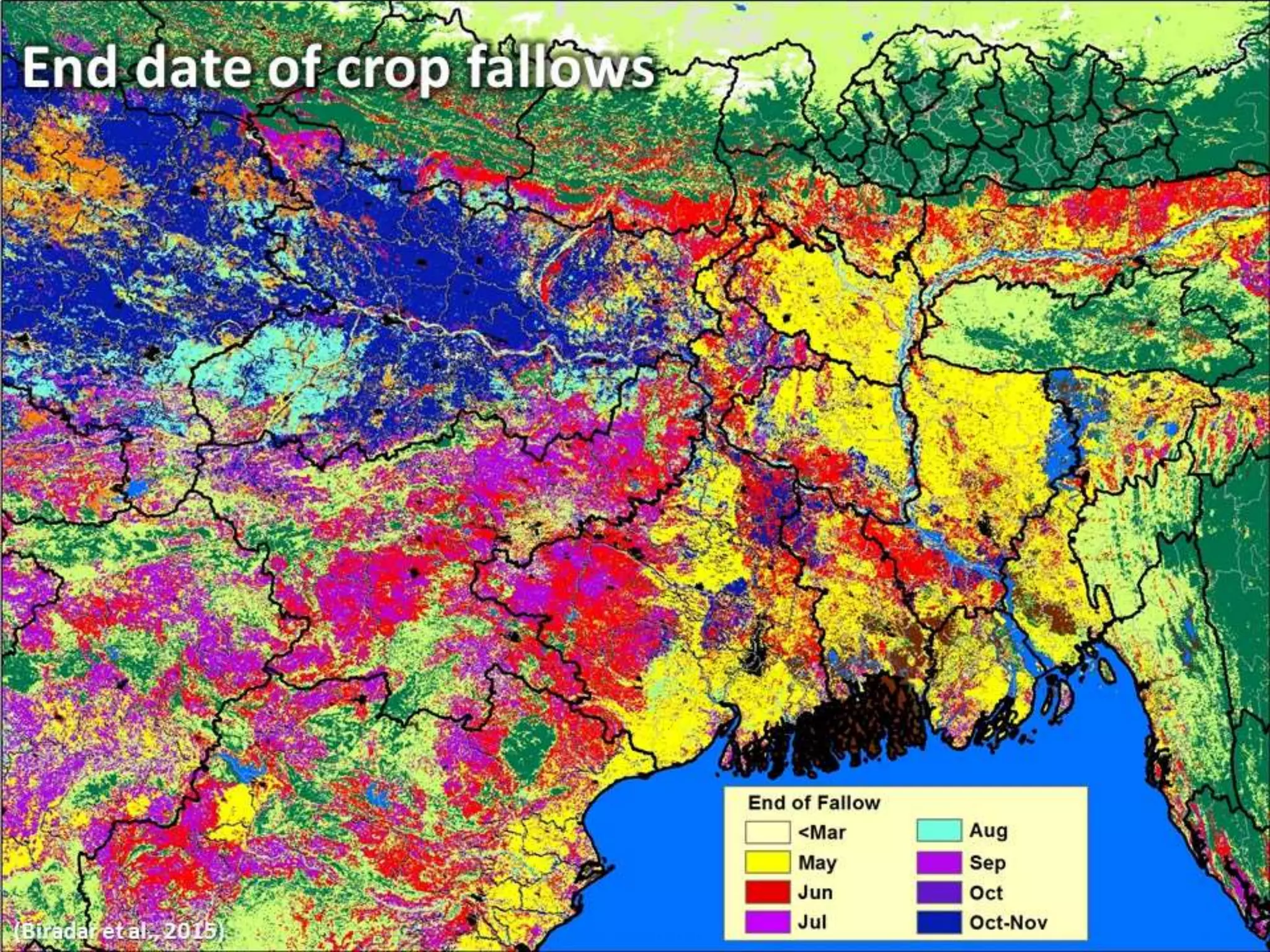
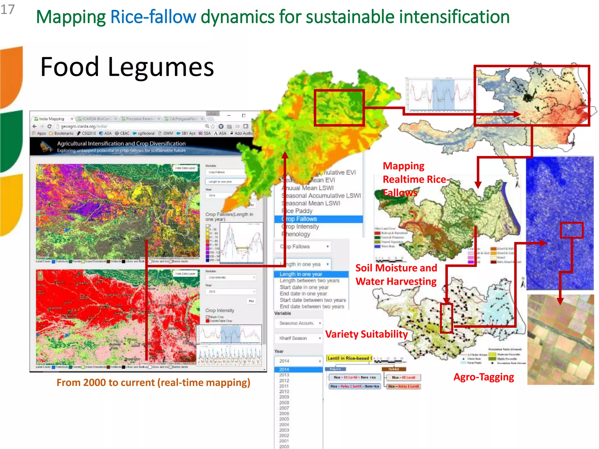
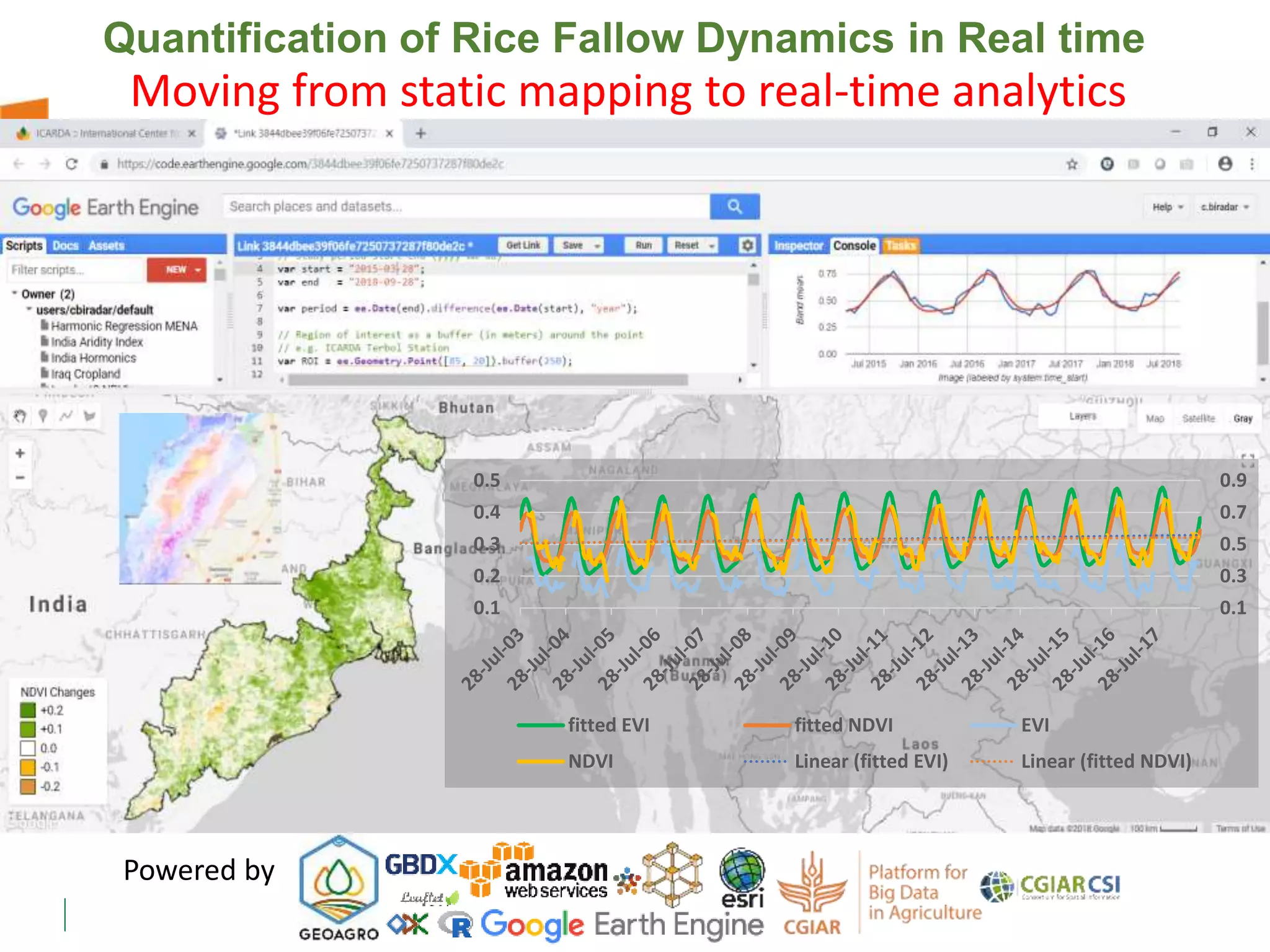
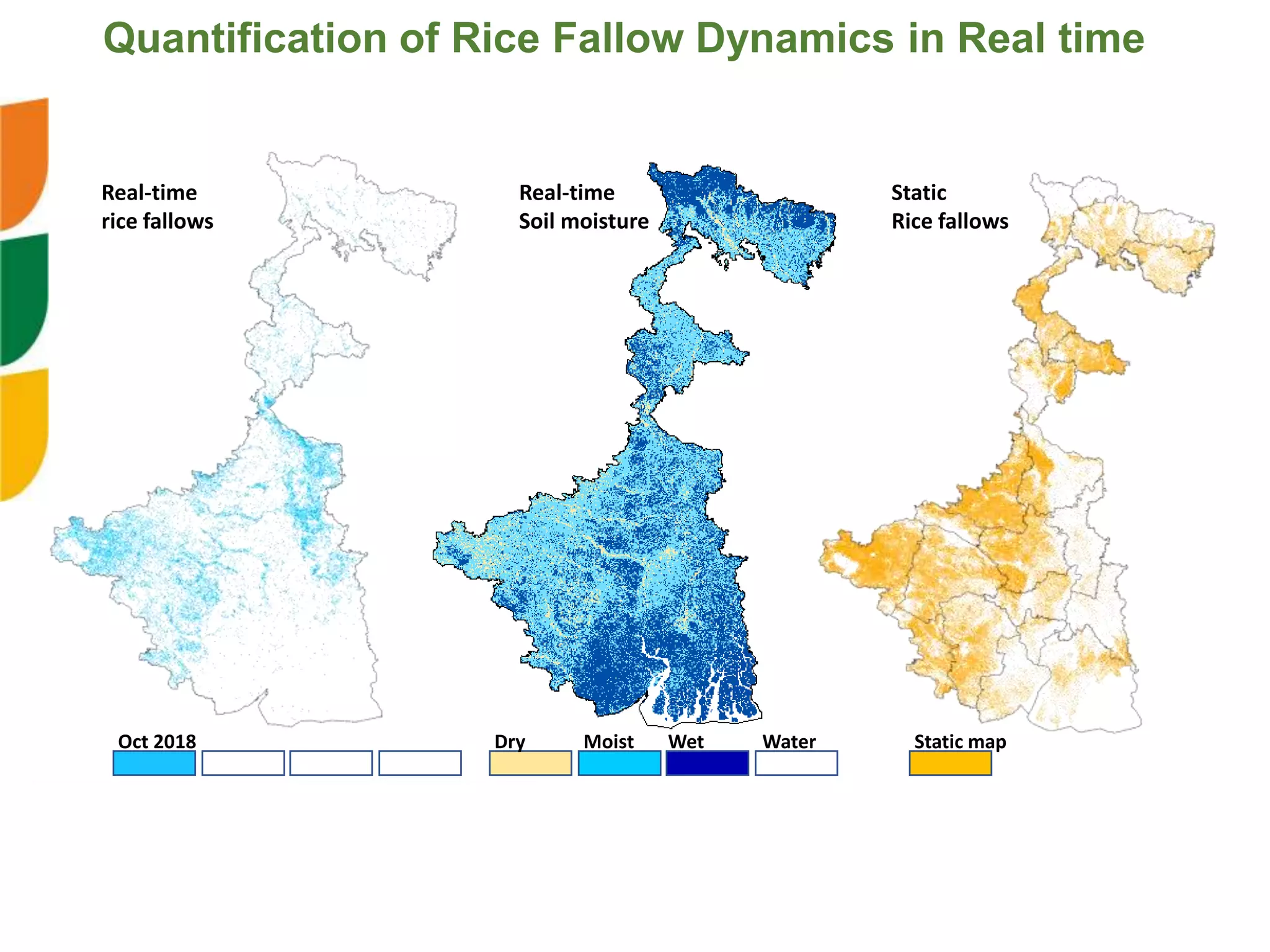
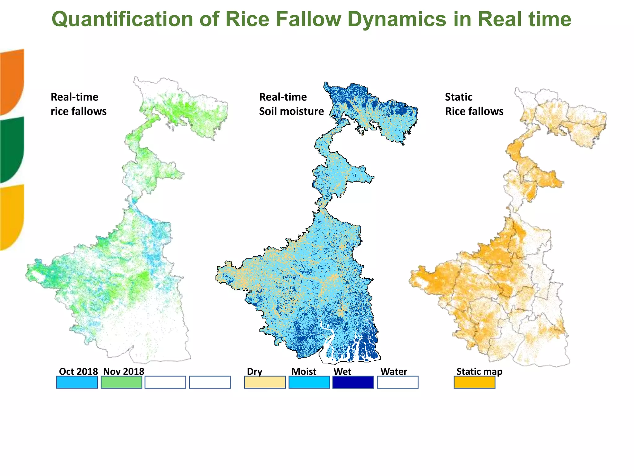
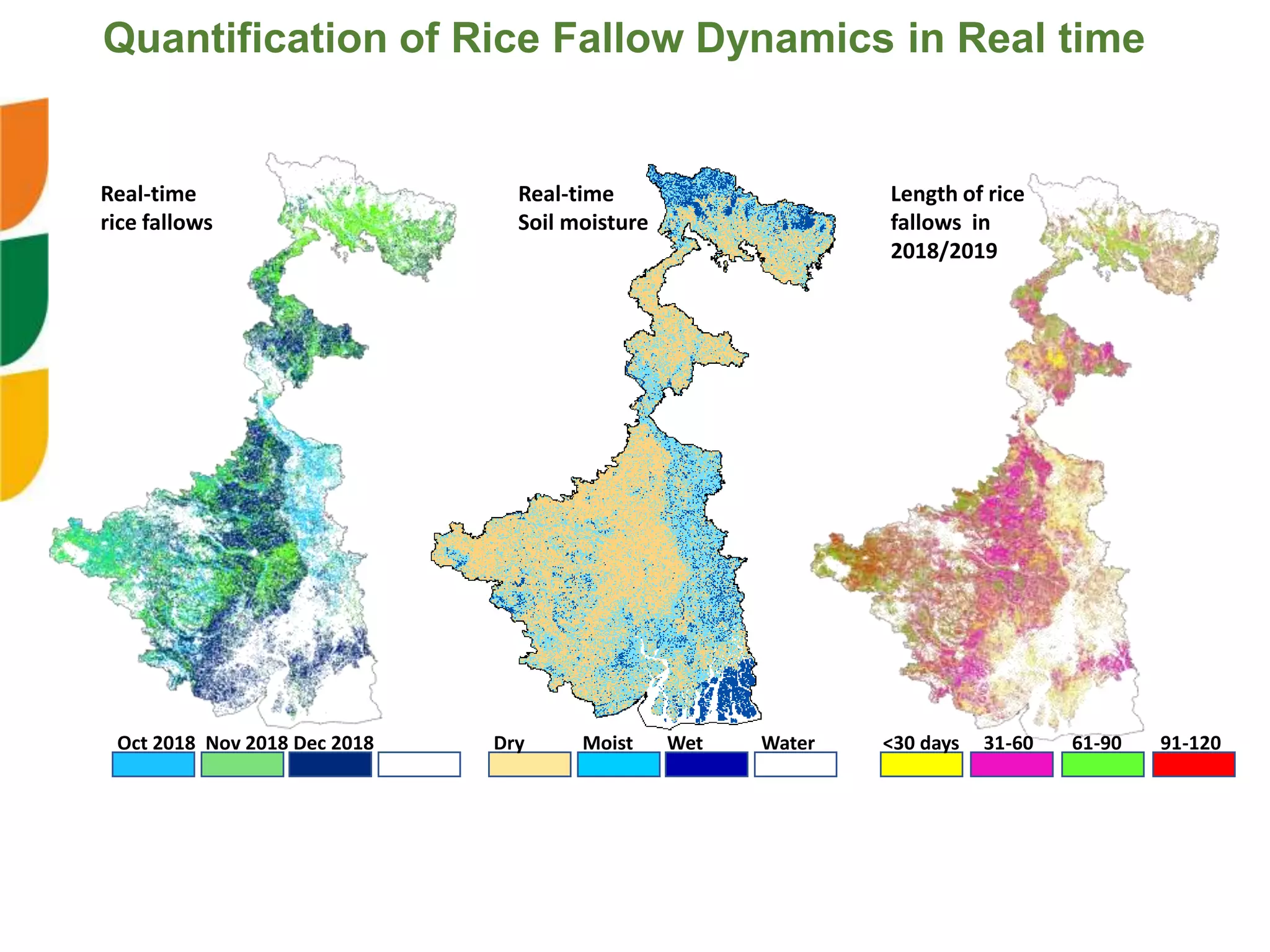
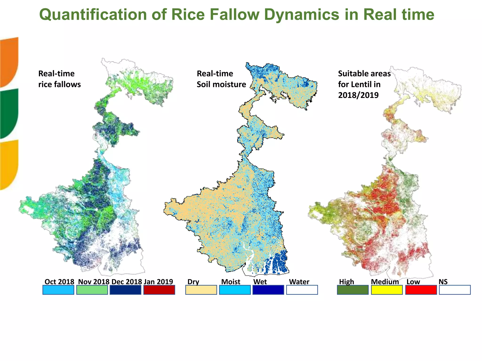
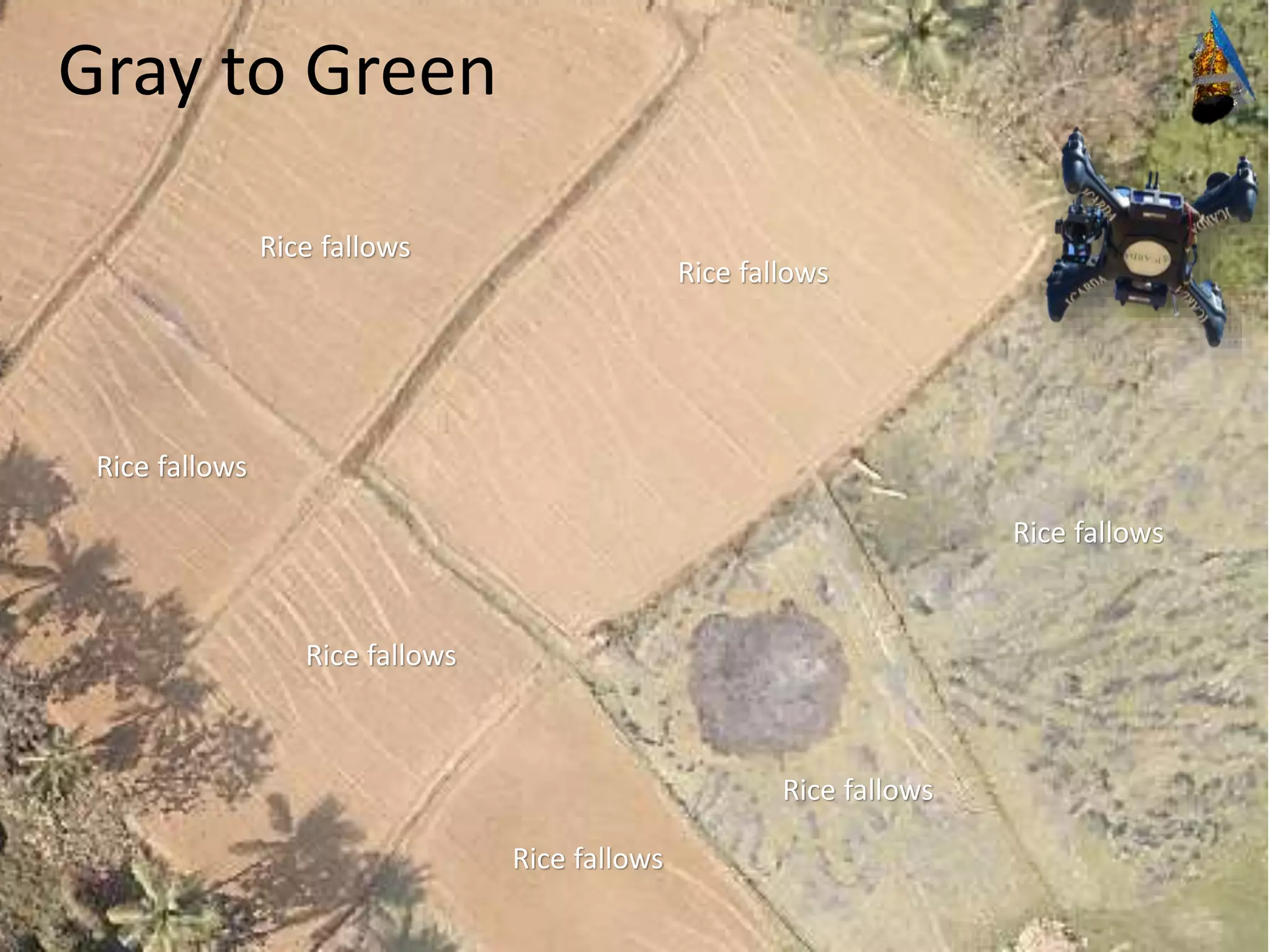
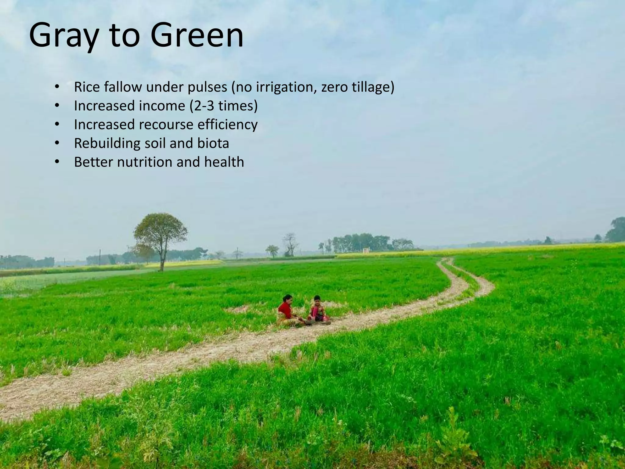
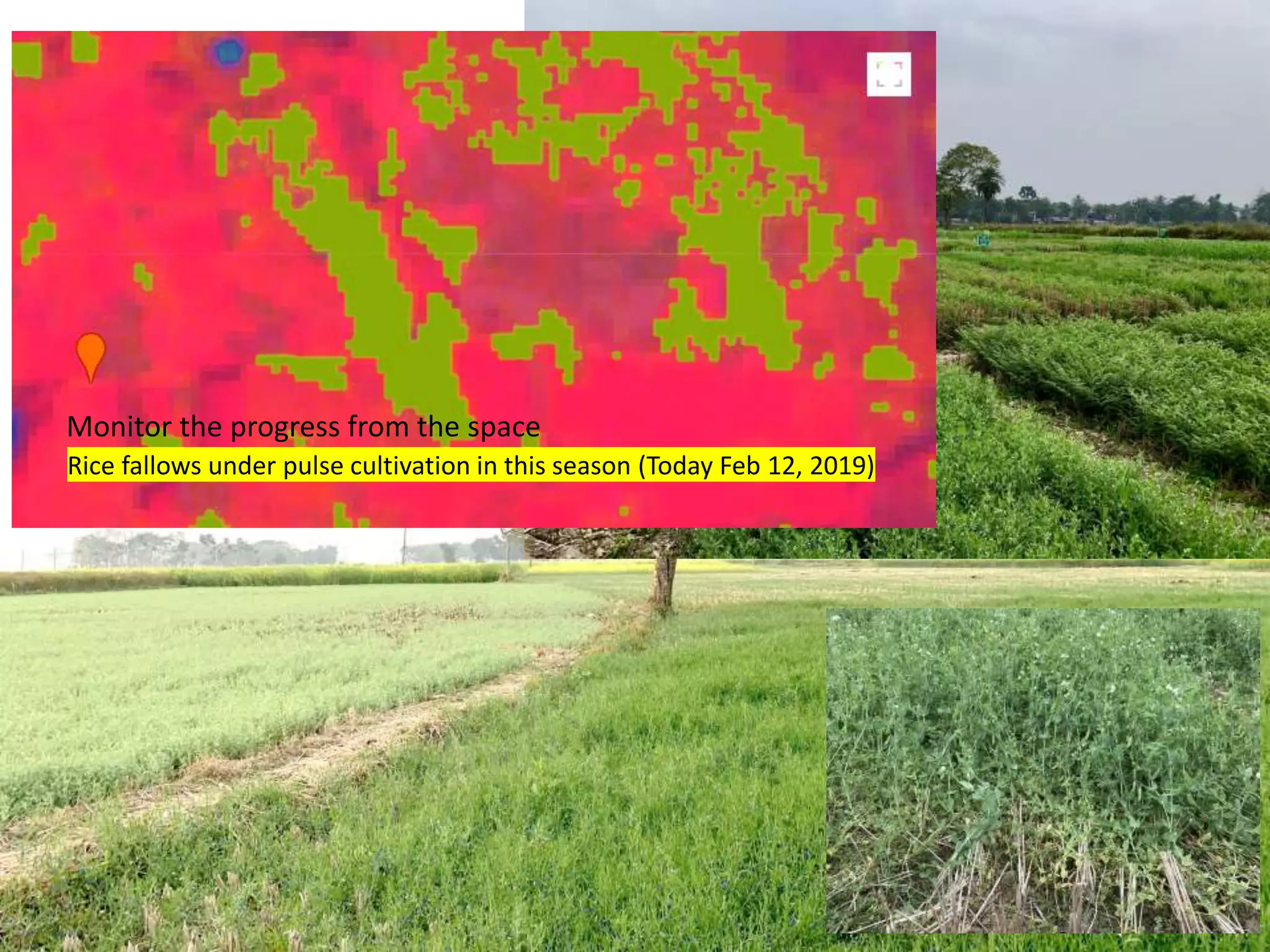
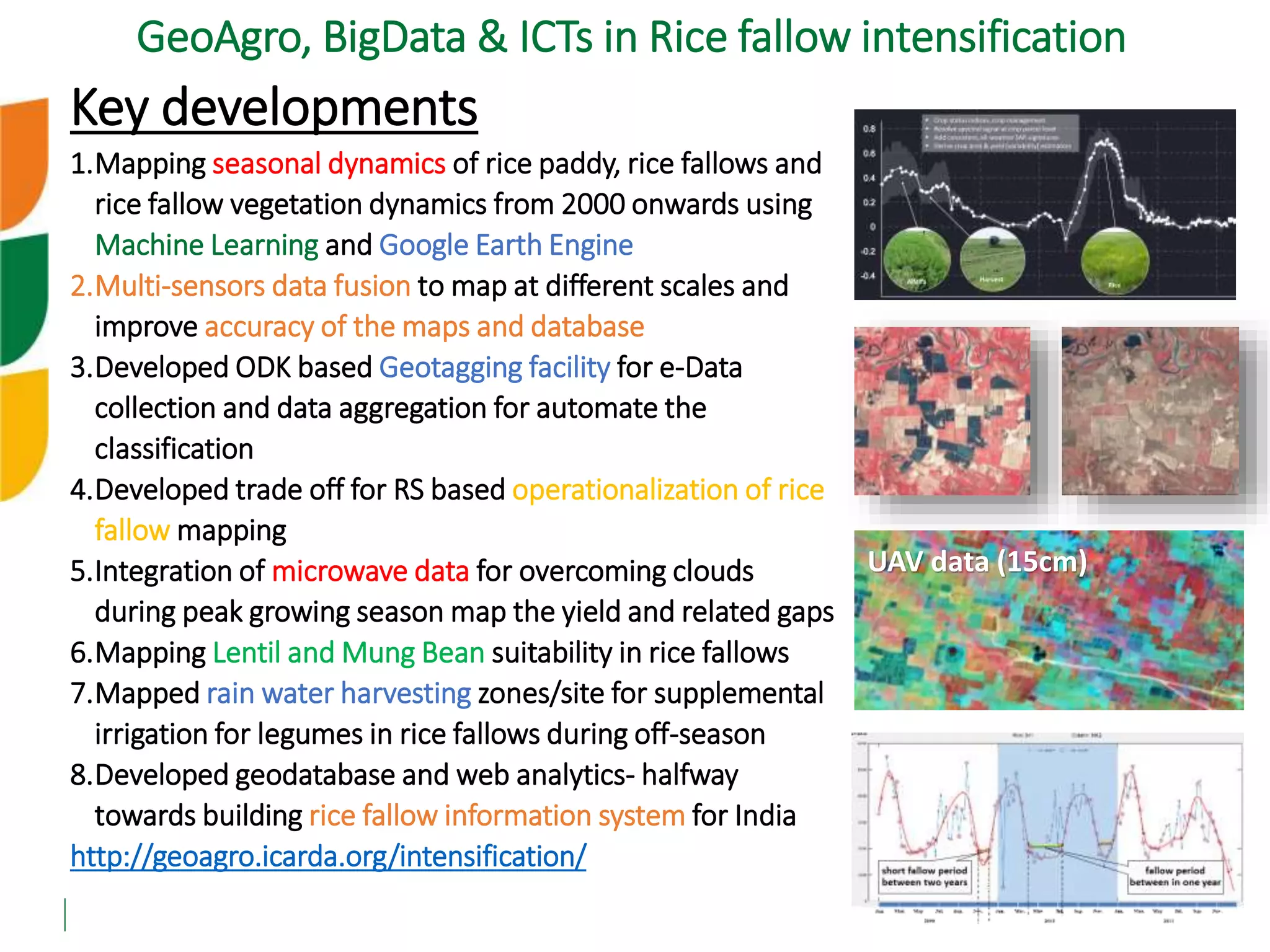
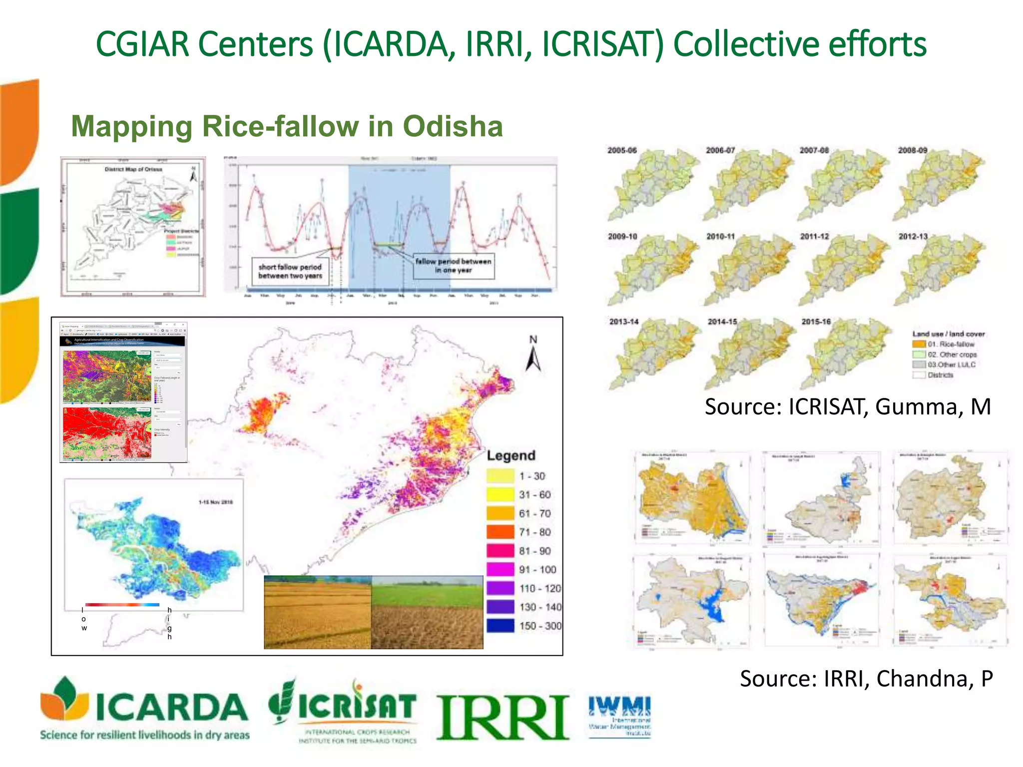
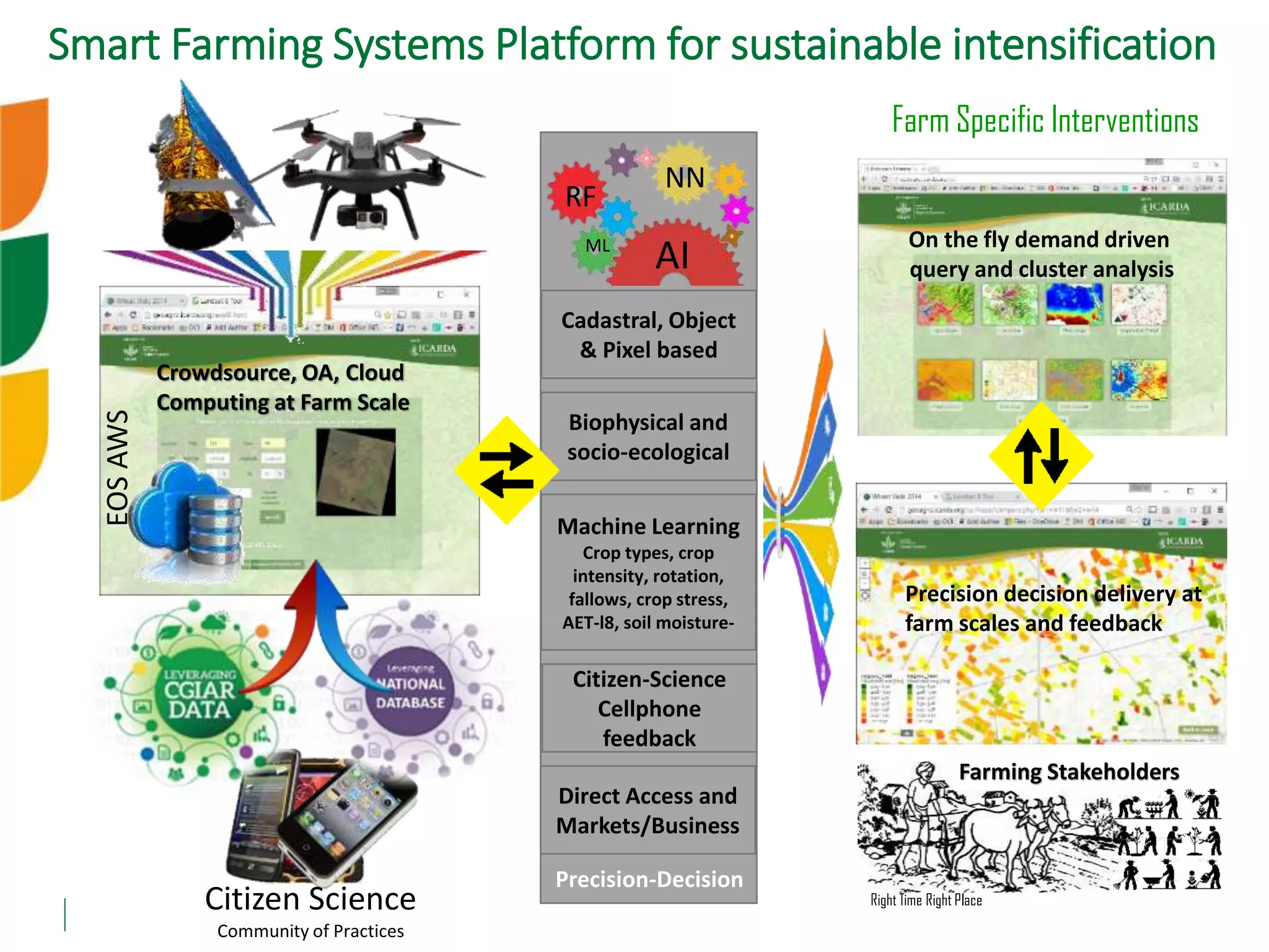
International Center for Agricultural Research in the Dry Areas
icarda.org cgiar.org
A CGIAR Research Center
Big Data and Digital Augmentation
for Accelerating Agroecological
Intensification
Biradar C, Ghosh S, Singh, R., Sarker A, Low,
F., Kumar S, AlShama K, Attasi L, Amri A,
Nangia V, Saharawat Y, Chandra P, Gumma
M, Behera M, Sahoo R, Rathod A, Winston,
W, Gaur A, Koo J, Ravan R, Aly, A and Werry J
Innovations for economically and
ecologically viable solutions
13th ICDD, Jodhpur
- more crop per drop
- in a inch of land and a bunch of crop
Increased land, water and system productivity while safe guarding
the environmental flows and ecosystem services
Data driven decision (space & time) for better strategy for
investment, intervention, implementation and impact
-water focus
-multi dimensions
-integrated systems
Ecological intensification
Target specific interventions
Bridging the gaps
Inputs use efficiency
Agricultural policy
Halt degradation
Technology scaling
- food and nutritional security
- resilience and risk reduction
- agro-ecosystem sustainability
- adaption and mitigation
- citizen science and collective actions
- equity in trade, social security and
stability
Resilient Agroecosystems
<<<more health per acre>>>
icarda.org
Strategic Research Priorities
Genetic Resources: Mining crop diversity to develop germplasm resistant
to heat, drought, cold, disease, higher nutrients; International public goods (open access)
Adaption to Climate Change: Conventional and molecular
breeding to develop climate-smart crops and livestock
Building resilience: Integrated crop-livestock farming systems to address
economic, social, and environmental conditions
Promoting value chains, policies: Agriculture as an income-
generating business for many poor smallholder households
Enhancing water, land productivity: Rainfed, irrigated, and
agro-pastoral farming; Reversal of environmental degradation; Enhance intensification
Big
Data
ICTs
Adoption of the SRPs in operational projects
New 9: 5 SRPs + 4 CCTs
Earth Observation and BIG DATA…
River Flow
Hydrology Energy
Livestock
Delta
Communication
Agriculture
Groundwater
Water use
Floods
Drought
Horticulture
Weather
Agro-biodiversity
Forestry
Pastures
Agro-
ecosystems
Inclusively
integrated
Agroforestry
Cross-cutting disciplines and trade offs
Digitization of farming systems
Geo-Tagging
Satellite data
Crop data
Climate data
Soil data
Water data
Topography
Demography
Ecological data
…
Mapping
Monitoring
Targeting
Estimating
Forecasting
Warning
Lending
Insurance
Value chains
Carbon-Credits
Data Layers
Computation
Applications
AI
ML
RF IOT
Scalability
Algorithms
Biggest drivers
research & outreach data
Geo-taging and Agro-tagging
Big data and Citizen science driven
AI
ML
Meta Analytics
Big
Data
@ genetics, chemistry, weather, agronomy, trade…
Inclusive
Agroecosystems
Demand driven
Sustainable options
Big Data is in everything and everywhere
icarda.org
2000 to 2018
Tracing the changes to target interventions
Nile Delta
Quantification of Farming Systems @ multiple-scalesDigitalAgPlatform
Build
resilient
agroecosystems
Ecological intensification
Financial inclusion
Resilient cropping systems
better integration of crops, livestock, fish, trees & people
Optimizing resource use by integrated approach
compound intensification in cereal based systems
Right crop at right place and time
Better livelihoods
1. Functional productivity
2. Yield & Rotation
3. Crop growth
4. Incentives
Pixel/Farm/Parcel
A single entity for each &
every developmental
entry point
30m
10m
1.0m
0.3m
Open source
3 days revisit
<Biggest drivers
Agreements
Evolving areas in Big Data
Science in inclusive
Agriculture
Paradigm shift to functional systems for
ecologically and economically viable options
Better integration Better measurements Better modelling Resilient Systems
Rebuilding functional productivity is the key to
exponential efficiency and growth in the world largest
and oldest industry which has capacity fix most issues
1983 1985 1987 1989 1991 1993 1995 1997 1999 2001 2003 2005 2007 2009 2011 2013 2015 2017 2018
Monitoring fieldsImaging the past, (re)construct field´s history, retrospective assessments
2019
Moving from narrow sense economic benefit to a new
ecologically sound functional model for well being…
One use case#1:
Sustainable intensification of
rice-based systems in India
Fallows in Double cropped area Fallows in Single cropped area
Dynamics of rice fallow systems in target
districts, West Bengal, India
15
#/km2
Dynamics of Cropping Systems
▪ Integrated Agro-Ecosystems
▪ Sustainable Intensification and Diversification
▪ Input Use Efficiency-Conservation Agriculture
▪ Thematic Land-Water-Climate Resilience
Agricultural
Intensification
Cropping
Intensity
Increase in
Arable Land
72%
21%
7%
Biradar and Xiao, 2009
Length of the crop fallows, start-date, end-date
(Biradar et al., 2015)
17
Mapping Rice-fallow dynamics for sustainable intensification
From 2000 to current (real-time mapping)
Mapping
Realtime Rice-
Fallows
Soil Moisture and
Water Harvesting
Variety Suitability
Agro-Tagging
Food Legumes
0.1
0.3
0.5
0.7
0.9
0.1
0.2
0.3
0.4
0.5
fitted EVI fitted NDVI EVI
NDVI Linear (fitted EVI) Linear (fitted NDVI)
Quantification of Rice Fallow Dynamics in Real time
Powered by
Moving from static mapping to real-time analytics
Oct 2018 Dry Moist Wet Water
Real-time
rice fallows
Real-time
Soil moisture
Static map
Static
Rice fallows
Quantification of Rice Fallow Dynamics in Real time
Oct 2018 Nov 2018 Dry Moist Wet Water
Real-time
rice fallows
Real-time
Soil moisture
Static map
Static
Rice fallows
Quantification of Rice Fallow Dynamics in Real time
Oct 2018 Nov 2018 Dec 2018 Dry Moist Wet Water
Real-time
rice fallows
Real-time
Soil moisture
Length of rice
fallows in
2018/2019
Quantification of Rice Fallow Dynamics in Real time
<30 days 31-60 61-90 91-120
Oct 2018 Nov 2018 Dec 2018 Jan 2019 Dry Moist Wet Water
Real-time
rice fallows
Real-time
Soil moisture
High Medium Low NS
Suitable areas
for Lentil in
2018/2019
Quantification of Rice Fallow Dynamics in Real time
23
Rice fallows
Rice fallows
Rice fallows
Rice fallows
Rice fallows
Rice fallows
Rice fallows
Gray to Green
24
Gray to Green
• Rice fallow under pulses (no irrigation, zero tillage)
• Increased income (2-3 times)
• Increased recourse efficiency
• Rebuilding soil and biota
• Better nutrition and health
25
Rice fallows under pulse cultivation in this season (Today Feb 12, 2019)
Monitor the progress from the space
26
27
Key developments
1.Mapping seasonal dynamics of rice paddy, rice fallows and
rice fallow vegetation dynamics from 2000 onwards using
Machine Learning and Google Earth Engine
2.Multi-sensors data fusion to map at different scales and
improve accuracy of the maps and database
3.Developed ODK based Geotagging facility for e-Data
collection and data aggregation for automate the
classification
4.Developed trade off for RS based operationalization of rice
fallow mapping
5.Integration of microwave data for overcoming clouds
during peak growing season map the yield and related gaps
6.Mapping Lentil and Mung Bean suitability in rice fallows
7.Mapped rain water harvesting zones/site for supplemental
irrigation for legumes in rice fallows during off-season
8.Developed geodatabase and web analytics- halfway
towards building rice fallow information system for India
http://geoagro.icarda.org/intensification/
GeoAgro, BigData & ICTs in Rice fallow intensification
UAV data (15cm)
Mapping Rice-fallow in Odisha
CGIAR Centers (ICARDA, IRRI, ICRISAT) Collective efforts
l
o
w
h
i
g
h
Source: ICRISAT, Gumma, M
Source: IRRI, Chandna, P
Smart Farming Systems Platform for sustainable intensification
On the fly demand driven
query and cluster analysis
Cadastral, Object
& Pixel based
Biophysical and
socio-ecological
Machine Learning
Crop types, crop
intensity, rotation,
fallows, crop stress,
AET-l8, soil moisture-
Citizen-Science
Cellphone
feedback
Direct Access and
Markets/Business
Precision decision delivery at
farm scales and feedback
Crowdsource, OA, Cloud
Computing at Farm Scale
Precision-Decision
Citizen Science
Community of Practices
Farming Stakeholders
EOSAWS
AI
NN
RF
ML
Farm Specific Interventions
Right Time Right Place
Thank You
c.biradar@cgiar.org
Production follows functions
Building functional feedback system through
integration of crops, trees and animals
Chandrashekhar Biradar
Head-Geoinformatics Unit
Principal Scientist (Agro-Ecosystems)

Big Data and Digital Augmentation for Accelerating Agroecological Intensification

  • 1.
    International Center forAgricultural Research in the Dry Areas icarda.org cgiar.org A CGIAR Research Center Big Data and Digital Augmentation for Accelerating Agroecological Intensification Biradar C, Ghosh S, Singh, R., Sarker A, Low, F., Kumar S, AlShama K, Attasi L, Amri A, Nangia V, Saharawat Y, Chandra P, Gumma M, Behera M, Sahoo R, Rathod A, Winston, W, Gaur A, Koo J, Ravan R, Aly, A and Werry J Innovations for economically and ecologically viable solutions 13th ICDD, Jodhpur
  • 2.
    - more cropper drop - in a inch of land and a bunch of crop Increased land, water and system productivity while safe guarding the environmental flows and ecosystem services Data driven decision (space & time) for better strategy for investment, intervention, implementation and impact -water focus -multi dimensions -integrated systems Ecological intensification Target specific interventions Bridging the gaps Inputs use efficiency Agricultural policy Halt degradation Technology scaling - food and nutritional security - resilience and risk reduction - agro-ecosystem sustainability - adaption and mitigation - citizen science and collective actions - equity in trade, social security and stability Resilient Agroecosystems <<<more health per acre>>>
  • 3.
    icarda.org Strategic Research Priorities GeneticResources: Mining crop diversity to develop germplasm resistant to heat, drought, cold, disease, higher nutrients; International public goods (open access) Adaption to Climate Change: Conventional and molecular breeding to develop climate-smart crops and livestock Building resilience: Integrated crop-livestock farming systems to address economic, social, and environmental conditions Promoting value chains, policies: Agriculture as an income- generating business for many poor smallholder households Enhancing water, land productivity: Rainfed, irrigated, and agro-pastoral farming; Reversal of environmental degradation; Enhance intensification Big Data ICTs Adoption of the SRPs in operational projects New 9: 5 SRPs + 4 CCTs
  • 4.
    Earth Observation andBIG DATA… River Flow Hydrology Energy Livestock Delta Communication Agriculture Groundwater Water use Floods Drought Horticulture Weather Agro-biodiversity Forestry Pastures Agro- ecosystems Inclusively integrated Agroforestry
  • 6.
  • 7.
    Digitization of farmingsystems Geo-Tagging Satellite data Crop data Climate data Soil data Water data Topography Demography Ecological data … Mapping Monitoring Targeting Estimating Forecasting Warning Lending Insurance Value chains Carbon-Credits Data Layers Computation Applications AI ML RF IOT Scalability Algorithms Biggest drivers research & outreach data Geo-taging and Agro-tagging Big data and Citizen science driven
  • 8.
    AI ML Meta Analytics Big Data @ genetics,chemistry, weather, agronomy, trade… Inclusive Agroecosystems Demand driven Sustainable options Big Data is in everything and everywhere
  • 9.
    icarda.org 2000 to 2018 Tracingthe changes to target interventions Nile Delta
  • 10.
    Quantification of FarmingSystems @ multiple-scalesDigitalAgPlatform
  • 11.
    Build resilient agroecosystems Ecological intensification Financial inclusion Resilientcropping systems better integration of crops, livestock, fish, trees & people Optimizing resource use by integrated approach compound intensification in cereal based systems Right crop at right place and time Better livelihoods 1. Functional productivity 2. Yield & Rotation 3. Crop growth 4. Incentives Pixel/Farm/Parcel A single entity for each & every developmental entry point 30m 10m 1.0m 0.3m Open source 3 days revisit <Biggest drivers Agreements Evolving areas in Big Data Science in inclusive Agriculture Paradigm shift to functional systems for ecologically and economically viable options
  • 12.
    Better integration Bettermeasurements Better modelling Resilient Systems Rebuilding functional productivity is the key to exponential efficiency and growth in the world largest and oldest industry which has capacity fix most issues 1983 1985 1987 1989 1991 1993 1995 1997 1999 2001 2003 2005 2007 2009 2011 2013 2015 2017 2018 Monitoring fieldsImaging the past, (re)construct field´s history, retrospective assessments 2019 Moving from narrow sense economic benefit to a new ecologically sound functional model for well being…
  • 13.
    One use case#1: Sustainableintensification of rice-based systems in India
  • 14.
    Fallows in Doublecropped area Fallows in Single cropped area Dynamics of rice fallow systems in target districts, West Bengal, India
  • 15.
    15 #/km2 Dynamics of CroppingSystems ▪ Integrated Agro-Ecosystems ▪ Sustainable Intensification and Diversification ▪ Input Use Efficiency-Conservation Agriculture ▪ Thematic Land-Water-Climate Resilience Agricultural Intensification Cropping Intensity Increase in Arable Land 72% 21% 7% Biradar and Xiao, 2009 Length of the crop fallows, start-date, end-date (Biradar et al., 2015)
  • 17.
    17 Mapping Rice-fallow dynamicsfor sustainable intensification From 2000 to current (real-time mapping) Mapping Realtime Rice- Fallows Soil Moisture and Water Harvesting Variety Suitability Agro-Tagging Food Legumes
  • 18.
    0.1 0.3 0.5 0.7 0.9 0.1 0.2 0.3 0.4 0.5 fitted EVI fittedNDVI EVI NDVI Linear (fitted EVI) Linear (fitted NDVI) Quantification of Rice Fallow Dynamics in Real time Powered by Moving from static mapping to real-time analytics
  • 19.
    Oct 2018 DryMoist Wet Water Real-time rice fallows Real-time Soil moisture Static map Static Rice fallows Quantification of Rice Fallow Dynamics in Real time
  • 20.
    Oct 2018 Nov2018 Dry Moist Wet Water Real-time rice fallows Real-time Soil moisture Static map Static Rice fallows Quantification of Rice Fallow Dynamics in Real time
  • 21.
    Oct 2018 Nov2018 Dec 2018 Dry Moist Wet Water Real-time rice fallows Real-time Soil moisture Length of rice fallows in 2018/2019 Quantification of Rice Fallow Dynamics in Real time <30 days 31-60 61-90 91-120
  • 22.
    Oct 2018 Nov2018 Dec 2018 Jan 2019 Dry Moist Wet Water Real-time rice fallows Real-time Soil moisture High Medium Low NS Suitable areas for Lentil in 2018/2019 Quantification of Rice Fallow Dynamics in Real time
  • 23.
    23 Rice fallows Rice fallows Ricefallows Rice fallows Rice fallows Rice fallows Rice fallows Gray to Green
  • 24.
    24 Gray to Green •Rice fallow under pulses (no irrigation, zero tillage) • Increased income (2-3 times) • Increased recourse efficiency • Rebuilding soil and biota • Better nutrition and health
  • 25.
    25 Rice fallows underpulse cultivation in this season (Today Feb 12, 2019) Monitor the progress from the space
  • 26.
  • 27.
  • 28.
    Key developments 1.Mapping seasonaldynamics of rice paddy, rice fallows and rice fallow vegetation dynamics from 2000 onwards using Machine Learning and Google Earth Engine 2.Multi-sensors data fusion to map at different scales and improve accuracy of the maps and database 3.Developed ODK based Geotagging facility for e-Data collection and data aggregation for automate the classification 4.Developed trade off for RS based operationalization of rice fallow mapping 5.Integration of microwave data for overcoming clouds during peak growing season map the yield and related gaps 6.Mapping Lentil and Mung Bean suitability in rice fallows 7.Mapped rain water harvesting zones/site for supplemental irrigation for legumes in rice fallows during off-season 8.Developed geodatabase and web analytics- halfway towards building rice fallow information system for India http://geoagro.icarda.org/intensification/ GeoAgro, BigData & ICTs in Rice fallow intensification UAV data (15cm)
  • 29.
    Mapping Rice-fallow inOdisha CGIAR Centers (ICARDA, IRRI, ICRISAT) Collective efforts l o w h i g h Source: ICRISAT, Gumma, M Source: IRRI, Chandna, P
  • 30.
    Smart Farming SystemsPlatform for sustainable intensification On the fly demand driven query and cluster analysis Cadastral, Object & Pixel based Biophysical and socio-ecological Machine Learning Crop types, crop intensity, rotation, fallows, crop stress, AET-l8, soil moisture- Citizen-Science Cellphone feedback Direct Access and Markets/Business Precision decision delivery at farm scales and feedback Crowdsource, OA, Cloud Computing at Farm Scale Precision-Decision Citizen Science Community of Practices Farming Stakeholders EOSAWS AI NN RF ML Farm Specific Interventions Right Time Right Place
  • 32.
    Thank You c.biradar@cgiar.org Production followsfunctions Building functional feedback system through integration of crops, trees and animals Chandrashekhar Biradar Head-Geoinformatics Unit Principal Scientist (Agro-Ecosystems)