SlideShare a Scribd company logo
The Power
  of the
  Image
   2011


                Beyond Google:
             mapping a new world of
            open data & open access

             Duncan Hill, Europa Technologies
The Power
  of the
  Image              Or...
   2011


             “I want something like
            Google Maps, but using
                   OS data”
The Power
  of the
  Image     Overview
   2011

            •   Where it all began
            •   What‟s possible today
            •   What we can learn from this
            •   How we can create our own basemaps
            •   ...and make these accessible
The Power
  of the
  Image     MapQuest launched 1996
   2011
The Power
  of the
  Image     Google Maps, today
   2011
The Power
  of the
  Image     Bing Maps
   2011
The Power
  of the
  Image     Google Maps API Styled Maps
   2011
The Power
  of the
  Image
                What people like / expect
   2011

            •   „Slippy‟ map interface
            •   Very fast drawing speeds
            •   Drill down for more detail
            •   High quality cartography
            •   Multi-platform support
The Power
  of the
  Image     Map tiles
   2011
The Power
  of the
  Image     Why use map tiles?
   2011

            • Pre-render for optimal performance
            • Reserve server resources for dynamic
              data
            • Merge tile layers on request for
              flexibility
            • Subtle cartographic effects
            • Accessible colour palette
            • Easy to use
            • Variety of hosting options
The Power
  of the
  Image     Considerations
   2011

            • Time required to perfect cartography
            • Rendering process very resource
              hungry
            • Not quick to produce a completely
              new output
            • Vectors still required for small % of
              users performing data capture
The Power
  of the
  Image     How will users consume maps?
   2011

            •   Desktop mapping applications
            •   Public facing web applications
            •   Intranet mapping applications
            •   Mobile (massive growth ahead)
The Power
  of the
  Image     Why wouldn‟t you use Google?
   2011

            •   Need more detail
            •   Need greater accuracy
            •   Need cartographic subtlety
            •   Complex technology landscape
            •   Licensing?
            •   “I want something that looks like
                Google Maps, but uses OS data”
The Power
  of the
  Image     PSMA
   2011

            • Public Sector Mapping Agreement
            • 10 year agreement
            • Public sector bodies in England &
              Wales
            • GB coverage, free at point of use
            • Allows data sharing
The Power
  of the
  Image     PSMA products
   2011

            • OS MasterMap Topography Layer
            • OS MasterMap Integrated Transport
              Network
            • 1:10,000 raster (until 31 March 2013)
            • OS VectorMap Local
            • 1:25,000 raster
            • 1:50,000 raster
            • Code-Point
            • Code-Point with Polygons
            • OS OpenData
            • National Address Gazetteer
The Power
  of the
  Image     Our workflow
   2011


                       Prepare
             Import              Render
                       & Style
The Power
  of the
  Image     viaEuropa
   2011
The Power
  of the
  Image     viaEuropa
   2011
The Power
  of the
  Image     viaEuropa
   2011
The Power
  of the
  Image     Examples
   2011

            •   OpenLayers
            •   Bing Maps
            •   Google Maps
            •   ESRI Silverlight API
            •   MapInfo Professional/ProViewer
            •   ArcGIS Desktop
            •   Cadcorp
The Power
  of the
  Image     Universal access
   2011

            • Support for those with a colour
              vision deficiency
               • 1 in 12 males
               • 1 in 100 females
            • Build accessibility in from outset
            • Avoid extra time & costs later
The Power
  of the
  Image     Universal access
   2011


                               Contains Ordnance Survey data © Crown copyright and database right 2010
The Power
  of the
  Image     Universal access
   2011


                               Contains Ordnance Survey data © Crown copyright and database right 2010
The Power
  of the
  Image     Universal access
   2011


                               Contains Ordnance Survey data © Crown copyright and database right 2010
The Power
  of the
  Image     Universal access
   2011


                               Contains Ordnance Survey data © Crown copyright and database right 2010
The Power
  of the
  Image     Summary
   2011

            • Consider the needs of your users
              • Who, why, what, when, how
            • Consistency across levels
            • Adopt a scalable approach
            • “Good designers decorate, great
              designers communicate” Cameron
              Moll, (Designer/Speaker/Author)
The Power
  of the
  Image     Thanks & Questions?
   2011


            dhill@europa.uk.com

            @duncanjfhill

            www.viaeuropa.uk.com

More Related Content

Viewers also liked

Ajourhold av N50 kartdata – før nå og så? - BK2016
Ajourhold av N50 kartdata – før nå og så? - BK2016Ajourhold av N50 kartdata – før nå og så? - BK2016
Ajourhold av N50 kartdata – før nå og så? - BK2016
Geodata AS
 
Data, Data, Everywhere. Now integrate & interact with it!
Data, Data, Everywhere. Now integrate & interact with it!Data, Data, Everywhere. Now integrate & interact with it!
Data, Data, Everywhere. Now integrate & interact with it!
British Cartographic Society
 
Gisday2012 pgd cyklodoprava_liberec_1
Gisday2012 pgd cyklodoprava_liberec_1Gisday2012 pgd cyklodoprava_liberec_1
Gisday2012 pgd cyklodoprava_liberec_1Jiří Šmída
 
Noaa Map Project
Noaa Map ProjectNoaa Map Project
Noaa Map Project
Janelle Harrison
 
Comerma y arias capacidad de uso
Comerma y arias capacidad de usoComerma y arias capacidad de uso
Comerma y arias capacidad de uso
Instituto Nacional de Tierras
 
GIS and Open Source
GIS and Open SourceGIS and Open Source
GIS and Open Source
Hardeep Rai
 
Cartographic language and portrayal
Cartographic language and portrayalCartographic language and portrayal
Cartographic language and portrayal
British Cartographic Society
 
Foss and GIS: Overview - Part 1
Foss and GIS: Overview - Part 1Foss and GIS: Overview - Part 1
Foss and GIS: Overview - Part 1
Hardeep Rai
 
Pioneros en la preservación de datos geográficos
Pioneros en la preservación de datos geográficosPioneros en la preservación de datos geográficos
Pioneros en la preservación de datos geográficos
Institut Cartogràfic de Catalunya
 
Geo database
Geo databaseGeo database
Geo database
steenfauerby
 
Cartography and Geospatial Intelligence (GEOINT): Actionable Knowledge for Hu...
Cartography and Geospatial Intelligence (GEOINT): Actionable Knowledge for Hu...Cartography and Geospatial Intelligence (GEOINT): Actionable Knowledge for Hu...
Cartography and Geospatial Intelligence (GEOINT): Actionable Knowledge for Hu...
British Cartographic Society
 
Distribució de productes ICC en ETRS89
Distribució de productes ICC en ETRS89Distribució de productes ICC en ETRS89
Distribució de productes ICC en ETRS89
Institut Cartogràfic de Catalunya
 
Model de la Base topogràfica 1:5.000
Model de la Base topogràfica 1:5.000Model de la Base topogràfica 1:5.000
Model de la Base topogràfica 1:5.000
Institut Cartogràfic de Catalunya
 
Active Transportation Consulting Portfolio
Active Transportation Consulting PortfolioActive Transportation Consulting Portfolio
Active Transportation Consulting Portfolio
Anthony Smith
 
Digital Mapping
Digital MappingDigital Mapping
Digital Mapping
Hardeep Rai
 
Digital cartography and natural disaster management
Digital cartography and natural disaster managementDigital cartography and natural disaster management
Digital cartography and natural disaster management
GCUF
 
Stuart Miller - GIS Output and the Role of Cartography
Stuart Miller - GIS Output and the Role of CartographyStuart Miller - GIS Output and the Role of Cartography
Stuart Miller - GIS Output and the Role of Cartography
British Cartographic Society
 
3D Modeling by GIS
3D Modeling by GIS3D Modeling by GIS

Viewers also liked (20)

Ajourhold av N50 kartdata – før nå og så? - BK2016
Ajourhold av N50 kartdata – før nå og så? - BK2016Ajourhold av N50 kartdata – før nå og så? - BK2016
Ajourhold av N50 kartdata – før nå og så? - BK2016
 
Data, Data, Everywhere. Now integrate & interact with it!
Data, Data, Everywhere. Now integrate & interact with it!Data, Data, Everywhere. Now integrate & interact with it!
Data, Data, Everywhere. Now integrate & interact with it!
 
Gisday2012 pgd cyklodoprava_liberec_1
Gisday2012 pgd cyklodoprava_liberec_1Gisday2012 pgd cyklodoprava_liberec_1
Gisday2012 pgd cyklodoprava_liberec_1
 
SHA Poster2012
SHA Poster2012SHA Poster2012
SHA Poster2012
 
Noaa Map Project
Noaa Map ProjectNoaa Map Project
Noaa Map Project
 
Comerma y arias capacidad de uso
Comerma y arias capacidad de usoComerma y arias capacidad de uso
Comerma y arias capacidad de uso
 
GIS and Open Source
GIS and Open SourceGIS and Open Source
GIS and Open Source
 
Cartographic language and portrayal
Cartographic language and portrayalCartographic language and portrayal
Cartographic language and portrayal
 
Foss and GIS: Overview - Part 1
Foss and GIS: Overview - Part 1Foss and GIS: Overview - Part 1
Foss and GIS: Overview - Part 1
 
Pioneros en la preservación de datos geográficos
Pioneros en la preservación de datos geográficosPioneros en la preservación de datos geográficos
Pioneros en la preservación de datos geográficos
 
Gis 3 databaze_2012
Gis 3 databaze_2012Gis 3 databaze_2012
Gis 3 databaze_2012
 
Geo database
Geo databaseGeo database
Geo database
 
Cartography and Geospatial Intelligence (GEOINT): Actionable Knowledge for Hu...
Cartography and Geospatial Intelligence (GEOINT): Actionable Knowledge for Hu...Cartography and Geospatial Intelligence (GEOINT): Actionable Knowledge for Hu...
Cartography and Geospatial Intelligence (GEOINT): Actionable Knowledge for Hu...
 
Distribució de productes ICC en ETRS89
Distribució de productes ICC en ETRS89Distribució de productes ICC en ETRS89
Distribució de productes ICC en ETRS89
 
Model de la Base topogràfica 1:5.000
Model de la Base topogràfica 1:5.000Model de la Base topogràfica 1:5.000
Model de la Base topogràfica 1:5.000
 
Active Transportation Consulting Portfolio
Active Transportation Consulting PortfolioActive Transportation Consulting Portfolio
Active Transportation Consulting Portfolio
 
Digital Mapping
Digital MappingDigital Mapping
Digital Mapping
 
Digital cartography and natural disaster management
Digital cartography and natural disaster managementDigital cartography and natural disaster management
Digital cartography and natural disaster management
 
Stuart Miller - GIS Output and the Role of Cartography
Stuart Miller - GIS Output and the Role of CartographyStuart Miller - GIS Output and the Role of Cartography
Stuart Miller - GIS Output and the Role of Cartography
 
3D Modeling by GIS
3D Modeling by GIS3D Modeling by GIS
3D Modeling by GIS
 

Similar to Beyond Google: mapping a new world of open data and open access

Nearc2011 web state of art presentation
Nearc2011 web state of art presentationNearc2011 web state of art presentation
Nearc2011 web state of art presentation
Michael Terner
 
Usability Issues for Non-visual Interfaces to GI
Usability Issues for Non-visual Interfaces to GIUsability Issues for Non-visual Interfaces to GI
Usability Issues for Non-visual Interfaces to GI
British Cartographic Society
 
Going Mobile with HTML5
Going Mobile with HTML5Going Mobile with HTML5
Going Mobile with HTML5
John Reiser
 
8. beta pond peter_elgar
8. beta pond  peter_elgar8. beta pond  peter_elgar
8. beta pond peter_elgar
FOMS011
 
8. FOMS_ Betapond_ Peter_ Elgar
8. FOMS_ Betapond_ Peter_ Elgar8. FOMS_ Betapond_ Peter_ Elgar
8. FOMS_ Betapond_ Peter_ Elgar
FOMS011
 
Navigation & Location Europe 2009 Condensed
Navigation & Location Europe 2009 CondensedNavigation & Location Europe 2009 Condensed
Navigation & Location Europe 2009 Condensed
Alex Housley
 
Size does not matter (if your data is in a silo)
Size does not matter (if your data is in a silo)Size does not matter (if your data is in a silo)
Size does not matter (if your data is in a silo)
Ora Lassila
 
Advanced Maps on Apps for Series 40
Advanced Maps on Apps for Series 40Advanced Maps on Apps for Series 40
Advanced Maps on Apps for Series 40
Microsoft Mobile Developer
 
Creating Large-Scale Responsive Websites
Creating Large-Scale Responsive WebsitesCreating Large-Scale Responsive Websites
Creating Large-Scale Responsive Websites
Keith Doyle
 
State of the Map 2012 talk
State of the Map 2012 talkState of the Map 2012 talk
State of the Map 2012 talk
Wm Leler
 
NACIS 2012 talk
NACIS 2012 talkNACIS 2012 talk
NACIS 2012 talk
Wm Leler
 
What is Happening in the "App Factory"?
What is Happening in the "App Factory"?What is Happening in the "App Factory"?
What is Happening in the "App Factory"?
Ciklum Ukraine
 
Next Generation Open Data Platforms | AWS Public Sector Summit 2016
Next Generation Open Data Platforms | AWS Public Sector Summit 2016Next Generation Open Data Platforms | AWS Public Sector Summit 2016
Next Generation Open Data Platforms | AWS Public Sector Summit 2016
Amazon Web Services
 
Creating a Comprehensive Social Media App Using Ionic and Phone Gap
Creating a Comprehensive Social Media App Using Ionic and Phone GapCreating a Comprehensive Social Media App Using Ionic and Phone Gap
Creating a Comprehensive Social Media App Using Ionic and Phone Gap
FITC
 
A Visualization Application On AppEngine (Google Cloud)
A Visualization Application On AppEngine (Google Cloud)A Visualization Application On AppEngine (Google Cloud)
A Visualization Application On AppEngine (Google Cloud)
surprisedcloud
 
Web & Mobile GIS Overview at Middle TN Electric
Web & Mobile GIS Overview at Middle TN ElectricWeb & Mobile GIS Overview at Middle TN Electric
Web & Mobile GIS Overview at Middle TN Electric
True North Geographic Technologies
 
NYC Data Web (static version) - A Semantic, Open Public Data Exchange for NYC
NYC Data Web (static version) - A Semantic, Open Public Data Exchange for NYCNYC Data Web (static version) - A Semantic, Open Public Data Exchange for NYC
NYC Data Web (static version) - A Semantic, Open Public Data Exchange for NYC
Joel Natividad
 
European Location Framework
European Location FrameworkEuropean Location Framework
European Location Framework
Antti Jakobsson
 
Design and development of a mobile mashup application for geo-localized news ...
Design and development of a mobile mashup application for geo-localized news ...Design and development of a mobile mashup application for geo-localized news ...
Design and development of a mobile mashup application for geo-localized news ...
Kristina Stefanova
 
Mobile - trends, choices, plans
Mobile - trends, choices, plansMobile - trends, choices, plans
Mobile - trends, choices, plans
David Haskiya
 

Similar to Beyond Google: mapping a new world of open data and open access (20)

Nearc2011 web state of art presentation
Nearc2011 web state of art presentationNearc2011 web state of art presentation
Nearc2011 web state of art presentation
 
Usability Issues for Non-visual Interfaces to GI
Usability Issues for Non-visual Interfaces to GIUsability Issues for Non-visual Interfaces to GI
Usability Issues for Non-visual Interfaces to GI
 
Going Mobile with HTML5
Going Mobile with HTML5Going Mobile with HTML5
Going Mobile with HTML5
 
8. beta pond peter_elgar
8. beta pond  peter_elgar8. beta pond  peter_elgar
8. beta pond peter_elgar
 
8. FOMS_ Betapond_ Peter_ Elgar
8. FOMS_ Betapond_ Peter_ Elgar8. FOMS_ Betapond_ Peter_ Elgar
8. FOMS_ Betapond_ Peter_ Elgar
 
Navigation & Location Europe 2009 Condensed
Navigation & Location Europe 2009 CondensedNavigation & Location Europe 2009 Condensed
Navigation & Location Europe 2009 Condensed
 
Size does not matter (if your data is in a silo)
Size does not matter (if your data is in a silo)Size does not matter (if your data is in a silo)
Size does not matter (if your data is in a silo)
 
Advanced Maps on Apps for Series 40
Advanced Maps on Apps for Series 40Advanced Maps on Apps for Series 40
Advanced Maps on Apps for Series 40
 
Creating Large-Scale Responsive Websites
Creating Large-Scale Responsive WebsitesCreating Large-Scale Responsive Websites
Creating Large-Scale Responsive Websites
 
State of the Map 2012 talk
State of the Map 2012 talkState of the Map 2012 talk
State of the Map 2012 talk
 
NACIS 2012 talk
NACIS 2012 talkNACIS 2012 talk
NACIS 2012 talk
 
What is Happening in the "App Factory"?
What is Happening in the "App Factory"?What is Happening in the "App Factory"?
What is Happening in the "App Factory"?
 
Next Generation Open Data Platforms | AWS Public Sector Summit 2016
Next Generation Open Data Platforms | AWS Public Sector Summit 2016Next Generation Open Data Platforms | AWS Public Sector Summit 2016
Next Generation Open Data Platforms | AWS Public Sector Summit 2016
 
Creating a Comprehensive Social Media App Using Ionic and Phone Gap
Creating a Comprehensive Social Media App Using Ionic and Phone GapCreating a Comprehensive Social Media App Using Ionic and Phone Gap
Creating a Comprehensive Social Media App Using Ionic and Phone Gap
 
A Visualization Application On AppEngine (Google Cloud)
A Visualization Application On AppEngine (Google Cloud)A Visualization Application On AppEngine (Google Cloud)
A Visualization Application On AppEngine (Google Cloud)
 
Web & Mobile GIS Overview at Middle TN Electric
Web & Mobile GIS Overview at Middle TN ElectricWeb & Mobile GIS Overview at Middle TN Electric
Web & Mobile GIS Overview at Middle TN Electric
 
NYC Data Web (static version) - A Semantic, Open Public Data Exchange for NYC
NYC Data Web (static version) - A Semantic, Open Public Data Exchange for NYCNYC Data Web (static version) - A Semantic, Open Public Data Exchange for NYC
NYC Data Web (static version) - A Semantic, Open Public Data Exchange for NYC
 
European Location Framework
European Location FrameworkEuropean Location Framework
European Location Framework
 
Design and development of a mobile mashup application for geo-localized news ...
Design and development of a mobile mashup application for geo-localized news ...Design and development of a mobile mashup application for geo-localized news ...
Design and development of a mobile mashup application for geo-localized news ...
 
Mobile - trends, choices, plans
Mobile - trends, choices, plansMobile - trends, choices, plans
Mobile - trends, choices, plans
 

More from British Cartographic Society

Cartography and Web GIS - Jack Dangermond
Cartography and Web GIS - Jack DangermondCartography and Web GIS - Jack Dangermond
Cartography and Web GIS - Jack Dangermond
British Cartographic Society
 
Consequences of the modern mapping paradigm - Kenneth Field
Consequences of the modern mapping paradigm - Kenneth FieldConsequences of the modern mapping paradigm - Kenneth Field
Consequences of the modern mapping paradigm - Kenneth Field
British Cartographic Society
 
Water, Water Everywhere... - by Richard Carpenter, UKHO
Water, Water Everywhere... - by Richard Carpenter, UKHOWater, Water Everywhere... - by Richard Carpenter, UKHO
Water, Water Everywhere... - by Richard Carpenter, UKHO
British Cartographic Society
 
Designing mapping databases for the future: UKMap - the next generation - by ...
Designing mapping databases for the future: UKMap - the next generation - by ...Designing mapping databases for the future: UKMap - the next generation - by ...
Designing mapping databases for the future: UKMap - the next generation - by ...
British Cartographic Society
 
Utility detection and mapping, setting the standards for the future - by Grah...
Utility detection and mapping, setting the standards for the future - by Grah...Utility detection and mapping, setting the standards for the future - by Grah...
Utility detection and mapping, setting the standards for the future - by Grah...
British Cartographic Society
 
Future mapping to reconstruct the past - by Jason Peters, Posthumous Plans
Future mapping to reconstruct the past - by Jason Peters, Posthumous PlansFuture mapping to reconstruct the past - by Jason Peters, Posthumous Plans
Future mapping to reconstruct the past - by Jason Peters, Posthumous Plans
British Cartographic Society
 
Mapping using the convergence of Survey and GIS - by Mike Cooper, Leica Geosy...
Mapping using the convergence of Survey and GIS - by Mike Cooper, Leica Geosy...Mapping using the convergence of Survey and GIS - by Mike Cooper, Leica Geosy...
Mapping using the convergence of Survey and GIS - by Mike Cooper, Leica Geosy...
British Cartographic Society
 
What can lessons from the last 30 years tell us about future mapping? - by To...
What can lessons from the last 30 years tell us about future mapping? - by To...What can lessons from the last 30 years tell us about future mapping? - by To...
What can lessons from the last 30 years tell us about future mapping? - by To...
British Cartographic Society
 
The Walker's Map: Designing GPS-enabled mapping for the urban recreational wa...
The Walker's Map: Designing GPS-enabled mapping for the urban recreational wa...The Walker's Map: Designing GPS-enabled mapping for the urban recreational wa...
The Walker's Map: Designing GPS-enabled mapping for the urban recreational wa...
British Cartographic Society
 
Mapping the Swiss Way esri-ch
Mapping the Swiss Way esri-chMapping the Swiss Way esri-ch
Mapping the Swiss Way esri-ch
British Cartographic Society
 
Freight Journey Planner for Transport for London
Freight Journey Planner for Transport for LondonFreight Journey Planner for Transport for London
Freight Journey Planner for Transport for London
British Cartographic Society
 
Mapping - for Solutions to Poverty
Mapping - for Solutions to PovertyMapping - for Solutions to Poverty
Mapping - for Solutions to Poverty
British Cartographic Society
 
Saving lives at sea: current activities and the use of GIS to understand a we...
Saving lives at sea: current activities and the use of GIS to understand a we...Saving lives at sea: current activities and the use of GIS to understand a we...
Saving lives at sea: current activities and the use of GIS to understand a we...
British Cartographic Society
 
Mapping birds, biodiversity and business: the role of GIS in conservation
Mapping birds, biodiversity and business: the role of GIS in conservationMapping birds, biodiversity and business: the role of GIS in conservation
Mapping birds, biodiversity and business: the role of GIS in conservation
British Cartographic Society
 
A series of deployments as seen through the maps, how they’ve changed and evo...
A series of deployments as seen through the maps, how they’ve changed and evo...A series of deployments as seen through the maps, how they’ve changed and evo...
A series of deployments as seen through the maps, how they’ve changed and evo...
British Cartographic Society
 
Mapping the Olympics: the example of the ‘Atlas of world sport’
Mapping the Olympics: the example of the ‘Atlas of world sport’Mapping the Olympics: the example of the ‘Atlas of world sport’
Mapping the Olympics: the example of the ‘Atlas of world sport’
British Cartographic Society
 
A century of geographical names: toponymic evolution in Somalia
A century of geographical names: toponymic evolution in SomaliaA century of geographical names: toponymic evolution in Somalia
A century of geographical names: toponymic evolution in Somalia
British Cartographic Society
 
GIS as an artistic medium - rendering the sublime
GIS as an artistic medium - rendering the sublimeGIS as an artistic medium - rendering the sublime
GIS as an artistic medium - rendering the sublime
British Cartographic Society
 
A common mapping symbology across national security stakeholders during the 2...
A common mapping symbology across national security stakeholders during the 2...A common mapping symbology across national security stakeholders during the 2...
A common mapping symbology across national security stakeholders during the 2...
British Cartographic Society
 
Which Way Is Up?
Which Way Is Up?Which Way Is Up?

More from British Cartographic Society (20)

Cartography and Web GIS - Jack Dangermond
Cartography and Web GIS - Jack DangermondCartography and Web GIS - Jack Dangermond
Cartography and Web GIS - Jack Dangermond
 
Consequences of the modern mapping paradigm - Kenneth Field
Consequences of the modern mapping paradigm - Kenneth FieldConsequences of the modern mapping paradigm - Kenneth Field
Consequences of the modern mapping paradigm - Kenneth Field
 
Water, Water Everywhere... - by Richard Carpenter, UKHO
Water, Water Everywhere... - by Richard Carpenter, UKHOWater, Water Everywhere... - by Richard Carpenter, UKHO
Water, Water Everywhere... - by Richard Carpenter, UKHO
 
Designing mapping databases for the future: UKMap - the next generation - by ...
Designing mapping databases for the future: UKMap - the next generation - by ...Designing mapping databases for the future: UKMap - the next generation - by ...
Designing mapping databases for the future: UKMap - the next generation - by ...
 
Utility detection and mapping, setting the standards for the future - by Grah...
Utility detection and mapping, setting the standards for the future - by Grah...Utility detection and mapping, setting the standards for the future - by Grah...
Utility detection and mapping, setting the standards for the future - by Grah...
 
Future mapping to reconstruct the past - by Jason Peters, Posthumous Plans
Future mapping to reconstruct the past - by Jason Peters, Posthumous PlansFuture mapping to reconstruct the past - by Jason Peters, Posthumous Plans
Future mapping to reconstruct the past - by Jason Peters, Posthumous Plans
 
Mapping using the convergence of Survey and GIS - by Mike Cooper, Leica Geosy...
Mapping using the convergence of Survey and GIS - by Mike Cooper, Leica Geosy...Mapping using the convergence of Survey and GIS - by Mike Cooper, Leica Geosy...
Mapping using the convergence of Survey and GIS - by Mike Cooper, Leica Geosy...
 
What can lessons from the last 30 years tell us about future mapping? - by To...
What can lessons from the last 30 years tell us about future mapping? - by To...What can lessons from the last 30 years tell us about future mapping? - by To...
What can lessons from the last 30 years tell us about future mapping? - by To...
 
The Walker's Map: Designing GPS-enabled mapping for the urban recreational wa...
The Walker's Map: Designing GPS-enabled mapping for the urban recreational wa...The Walker's Map: Designing GPS-enabled mapping for the urban recreational wa...
The Walker's Map: Designing GPS-enabled mapping for the urban recreational wa...
 
Mapping the Swiss Way esri-ch
Mapping the Swiss Way esri-chMapping the Swiss Way esri-ch
Mapping the Swiss Way esri-ch
 
Freight Journey Planner for Transport for London
Freight Journey Planner for Transport for LondonFreight Journey Planner for Transport for London
Freight Journey Planner for Transport for London
 
Mapping - for Solutions to Poverty
Mapping - for Solutions to PovertyMapping - for Solutions to Poverty
Mapping - for Solutions to Poverty
 
Saving lives at sea: current activities and the use of GIS to understand a we...
Saving lives at sea: current activities and the use of GIS to understand a we...Saving lives at sea: current activities and the use of GIS to understand a we...
Saving lives at sea: current activities and the use of GIS to understand a we...
 
Mapping birds, biodiversity and business: the role of GIS in conservation
Mapping birds, biodiversity and business: the role of GIS in conservationMapping birds, biodiversity and business: the role of GIS in conservation
Mapping birds, biodiversity and business: the role of GIS in conservation
 
A series of deployments as seen through the maps, how they’ve changed and evo...
A series of deployments as seen through the maps, how they’ve changed and evo...A series of deployments as seen through the maps, how they’ve changed and evo...
A series of deployments as seen through the maps, how they’ve changed and evo...
 
Mapping the Olympics: the example of the ‘Atlas of world sport’
Mapping the Olympics: the example of the ‘Atlas of world sport’Mapping the Olympics: the example of the ‘Atlas of world sport’
Mapping the Olympics: the example of the ‘Atlas of world sport’
 
A century of geographical names: toponymic evolution in Somalia
A century of geographical names: toponymic evolution in SomaliaA century of geographical names: toponymic evolution in Somalia
A century of geographical names: toponymic evolution in Somalia
 
GIS as an artistic medium - rendering the sublime
GIS as an artistic medium - rendering the sublimeGIS as an artistic medium - rendering the sublime
GIS as an artistic medium - rendering the sublime
 
A common mapping symbology across national security stakeholders during the 2...
A common mapping symbology across national security stakeholders during the 2...A common mapping symbology across national security stakeholders during the 2...
A common mapping symbology across national security stakeholders during the 2...
 
Which Way Is Up?
Which Way Is Up?Which Way Is Up?
Which Way Is Up?
 

Recently uploaded

Rethinking Kållered │ From Big Box to a Reuse Hub: A Transformation Journey ...
Rethinking Kållered │  From Big Box to a Reuse Hub: A Transformation Journey ...Rethinking Kållered │  From Big Box to a Reuse Hub: A Transformation Journey ...
Rethinking Kållered │ From Big Box to a Reuse Hub: A Transformation Journey ...
SirmaDuztepeliler
 
一比一原版(Rice毕业证)美国莱斯大学毕业证如何办理
一比一原版(Rice毕业证)美国莱斯大学毕业证如何办理一比一原版(Rice毕业证)美国莱斯大学毕业证如何办理
一比一原版(Rice毕业证)美国莱斯大学毕业证如何办理
oabn3692
 
一比一原版(ututaustin毕业证书)美国德克萨斯大学奥斯汀分校毕业证如何办理
一比一原版(ututaustin毕业证书)美国德克萨斯大学奥斯汀分校毕业证如何办理一比一原版(ututaustin毕业证书)美国德克萨斯大学奥斯汀分校毕业证如何办理
一比一原版(ututaustin毕业证书)美国德克萨斯大学奥斯汀分校毕业证如何办理
yqyquge
 
一比一原版(falmouth毕业证书)法尔茅斯大学毕业证如何办理
一比一原版(falmouth毕业证书)法尔茅斯大学毕业证如何办理一比一原版(falmouth毕业证书)法尔茅斯大学毕业证如何办理
一比一原版(falmouth毕业证书)法尔茅斯大学毕业证如何办理
xnhwr8v
 
一比一原版(lbs毕业证书)伦敦商学院毕业证如何办理
一比一原版(lbs毕业证书)伦敦商学院毕业证如何办理一比一原版(lbs毕业证书)伦敦商学院毕业证如何办理
一比一原版(lbs毕业证书)伦敦商学院毕业证如何办理
7jpwahiy
 
一比一原版(CSU毕业证书)查尔斯特大学毕业证如何办理
一比一原版(CSU毕业证书)查尔斯特大学毕业证如何办理一比一原版(CSU毕业证书)查尔斯特大学毕业证如何办理
一比一原版(CSU毕业证书)查尔斯特大学毕业证如何办理
67n7f53
 
一比一原版加拿大瑞尔森大学毕业证如何办理
一比一原版加拿大瑞尔森大学毕业证如何办理一比一原版加拿大瑞尔森大学毕业证如何办理
一比一原版加拿大瑞尔森大学毕业证如何办理
oydykuz
 
欧洲杯足彩-欧洲杯足彩买球软件-欧洲杯足彩买球软件下载|【​网址​🎉ac123.net🎉​】
欧洲杯足彩-欧洲杯足彩买球软件-欧洲杯足彩买球软件下载|【​网址​🎉ac123.net🎉​】欧洲杯足彩-欧洲杯足彩买球软件-欧洲杯足彩买球软件下载|【​网址​🎉ac123.net🎉​】
欧洲杯足彩-欧洲杯足彩买球软件-欧洲杯足彩买球软件下载|【​网址​🎉ac123.net🎉​】
batchelorerbm45967
 
一比一原版(NU毕业证书)诺森比亚大学毕业证如何办理
一比一原版(NU毕业证书)诺森比亚大学毕业证如何办理一比一原版(NU毕业证书)诺森比亚大学毕业证如何办理
一比一原版(NU毕业证书)诺森比亚大学毕业证如何办理
21uul8se
 
一比一原版(UCB毕业证)英国伯明翰大学学院毕业证如何办理
一比一原版(UCB毕业证)英国伯明翰大学学院毕业证如何办理一比一原版(UCB毕业证)英国伯明翰大学学院毕业证如何办理
一比一原版(UCB毕业证)英国伯明翰大学学院毕业证如何办理
zv943dhb
 
一比一原版(UC毕业证书)堪培拉大学毕业证如何办理
一比一原版(UC毕业证书)堪培拉大学毕业证如何办理一比一原版(UC毕业证书)堪培拉大学毕业证如何办理
一比一原版(UC毕业证书)堪培拉大学毕业证如何办理
wkip62b
 
一比一原版美国加州大学欧文分校毕业证(UCI学位证)如何办理
一比一原版美国加州大学欧文分校毕业证(UCI学位证)如何办理一比一原版美国加州大学欧文分校毕业证(UCI学位证)如何办理
一比一原版美国加州大学欧文分校毕业证(UCI学位证)如何办理
02tygie
 
一比一原版(KPU毕业证)加拿大昆特兰理工大学毕业证如何办理
一比一原版(KPU毕业证)加拿大昆特兰理工大学毕业证如何办理一比一原版(KPU毕业证)加拿大昆特兰理工大学毕业证如何办理
一比一原版(KPU毕业证)加拿大昆特兰理工大学毕业证如何办理
kmzsy4kn
 
一比一原版(UWS毕业证)澳洲西悉尼大学毕业证如何办理
一比一原版(UWS毕业证)澳洲西悉尼大学毕业证如何办理一比一原版(UWS毕业证)澳洲西悉尼大学毕业证如何办理
一比一原版(UWS毕业证)澳洲西悉尼大学毕业证如何办理
t34zod9l
 
一比一原版澳洲查理斯特大学毕业证(CSU学位证)如何办理
一比一原版澳洲查理斯特大学毕业证(CSU学位证)如何办理一比一原版澳洲查理斯特大学毕业证(CSU学位证)如何办理
一比一原版澳洲查理斯特大学毕业证(CSU学位证)如何办理
qa8dk1wm
 
一比一原版(CSUEB毕业证)美国加州州立大学东湾分校毕业证如何办理
一比一原版(CSUEB毕业证)美国加州州立大学东湾分校毕业证如何办理一比一原版(CSUEB毕业证)美国加州州立大学东湾分校毕业证如何办理
一比一原版(CSUEB毕业证)美国加州州立大学东湾分校毕业证如何办理
stgq9v39
 
欧洲杯足彩-欧洲杯足彩比赛投注-欧洲杯足彩比赛投注官网|【​网址​🎉ac10.net🎉​】
欧洲杯足彩-欧洲杯足彩比赛投注-欧洲杯足彩比赛投注官网|【​网址​🎉ac10.net🎉​】欧洲杯足彩-欧洲杯足彩比赛投注-欧洲杯足彩比赛投注官网|【​网址​🎉ac10.net🎉​】
欧洲杯足彩-欧洲杯足彩比赛投注-欧洲杯足彩比赛投注官网|【​网址​🎉ac10.net🎉​】
bljeremy734
 
一比一原版美国明尼苏达大学双城分校毕业证(UMTC学位证)如何办理
一比一原版美国明尼苏达大学双城分校毕业证(UMTC学位证)如何办理一比一原版美国明尼苏达大学双城分校毕业证(UMTC学位证)如何办理
一比一原版美国明尼苏达大学双城分校毕业证(UMTC学位证)如何办理
sf3cfttw
 
一比一原版(USQ毕业证书)南昆士兰大学毕业证如何办理
一比一原版(USQ毕业证书)南昆士兰大学毕业证如何办理一比一原版(USQ毕业证书)南昆士兰大学毕业证如何办理
一比一原版(USQ毕业证书)南昆士兰大学毕业证如何办理
p74xokfq
 
一比一原版澳洲科廷科技大学毕业证(Curtin毕业证)如何办理
一比一原版澳洲科廷科技大学毕业证(Curtin毕业证)如何办理一比一原版澳洲科廷科技大学毕业证(Curtin毕业证)如何办理
一比一原版澳洲科廷科技大学毕业证(Curtin毕业证)如何办理
bz42w9z0
 

Recently uploaded (20)

Rethinking Kållered │ From Big Box to a Reuse Hub: A Transformation Journey ...
Rethinking Kållered │  From Big Box to a Reuse Hub: A Transformation Journey ...Rethinking Kållered │  From Big Box to a Reuse Hub: A Transformation Journey ...
Rethinking Kållered │ From Big Box to a Reuse Hub: A Transformation Journey ...
 
一比一原版(Rice毕业证)美国莱斯大学毕业证如何办理
一比一原版(Rice毕业证)美国莱斯大学毕业证如何办理一比一原版(Rice毕业证)美国莱斯大学毕业证如何办理
一比一原版(Rice毕业证)美国莱斯大学毕业证如何办理
 
一比一原版(ututaustin毕业证书)美国德克萨斯大学奥斯汀分校毕业证如何办理
一比一原版(ututaustin毕业证书)美国德克萨斯大学奥斯汀分校毕业证如何办理一比一原版(ututaustin毕业证书)美国德克萨斯大学奥斯汀分校毕业证如何办理
一比一原版(ututaustin毕业证书)美国德克萨斯大学奥斯汀分校毕业证如何办理
 
一比一原版(falmouth毕业证书)法尔茅斯大学毕业证如何办理
一比一原版(falmouth毕业证书)法尔茅斯大学毕业证如何办理一比一原版(falmouth毕业证书)法尔茅斯大学毕业证如何办理
一比一原版(falmouth毕业证书)法尔茅斯大学毕业证如何办理
 
一比一原版(lbs毕业证书)伦敦商学院毕业证如何办理
一比一原版(lbs毕业证书)伦敦商学院毕业证如何办理一比一原版(lbs毕业证书)伦敦商学院毕业证如何办理
一比一原版(lbs毕业证书)伦敦商学院毕业证如何办理
 
一比一原版(CSU毕业证书)查尔斯特大学毕业证如何办理
一比一原版(CSU毕业证书)查尔斯特大学毕业证如何办理一比一原版(CSU毕业证书)查尔斯特大学毕业证如何办理
一比一原版(CSU毕业证书)查尔斯特大学毕业证如何办理
 
一比一原版加拿大瑞尔森大学毕业证如何办理
一比一原版加拿大瑞尔森大学毕业证如何办理一比一原版加拿大瑞尔森大学毕业证如何办理
一比一原版加拿大瑞尔森大学毕业证如何办理
 
欧洲杯足彩-欧洲杯足彩买球软件-欧洲杯足彩买球软件下载|【​网址​🎉ac123.net🎉​】
欧洲杯足彩-欧洲杯足彩买球软件-欧洲杯足彩买球软件下载|【​网址​🎉ac123.net🎉​】欧洲杯足彩-欧洲杯足彩买球软件-欧洲杯足彩买球软件下载|【​网址​🎉ac123.net🎉​】
欧洲杯足彩-欧洲杯足彩买球软件-欧洲杯足彩买球软件下载|【​网址​🎉ac123.net🎉​】
 
一比一原版(NU毕业证书)诺森比亚大学毕业证如何办理
一比一原版(NU毕业证书)诺森比亚大学毕业证如何办理一比一原版(NU毕业证书)诺森比亚大学毕业证如何办理
一比一原版(NU毕业证书)诺森比亚大学毕业证如何办理
 
一比一原版(UCB毕业证)英国伯明翰大学学院毕业证如何办理
一比一原版(UCB毕业证)英国伯明翰大学学院毕业证如何办理一比一原版(UCB毕业证)英国伯明翰大学学院毕业证如何办理
一比一原版(UCB毕业证)英国伯明翰大学学院毕业证如何办理
 
一比一原版(UC毕业证书)堪培拉大学毕业证如何办理
一比一原版(UC毕业证书)堪培拉大学毕业证如何办理一比一原版(UC毕业证书)堪培拉大学毕业证如何办理
一比一原版(UC毕业证书)堪培拉大学毕业证如何办理
 
一比一原版美国加州大学欧文分校毕业证(UCI学位证)如何办理
一比一原版美国加州大学欧文分校毕业证(UCI学位证)如何办理一比一原版美国加州大学欧文分校毕业证(UCI学位证)如何办理
一比一原版美国加州大学欧文分校毕业证(UCI学位证)如何办理
 
一比一原版(KPU毕业证)加拿大昆特兰理工大学毕业证如何办理
一比一原版(KPU毕业证)加拿大昆特兰理工大学毕业证如何办理一比一原版(KPU毕业证)加拿大昆特兰理工大学毕业证如何办理
一比一原版(KPU毕业证)加拿大昆特兰理工大学毕业证如何办理
 
一比一原版(UWS毕业证)澳洲西悉尼大学毕业证如何办理
一比一原版(UWS毕业证)澳洲西悉尼大学毕业证如何办理一比一原版(UWS毕业证)澳洲西悉尼大学毕业证如何办理
一比一原版(UWS毕业证)澳洲西悉尼大学毕业证如何办理
 
一比一原版澳洲查理斯特大学毕业证(CSU学位证)如何办理
一比一原版澳洲查理斯特大学毕业证(CSU学位证)如何办理一比一原版澳洲查理斯特大学毕业证(CSU学位证)如何办理
一比一原版澳洲查理斯特大学毕业证(CSU学位证)如何办理
 
一比一原版(CSUEB毕业证)美国加州州立大学东湾分校毕业证如何办理
一比一原版(CSUEB毕业证)美国加州州立大学东湾分校毕业证如何办理一比一原版(CSUEB毕业证)美国加州州立大学东湾分校毕业证如何办理
一比一原版(CSUEB毕业证)美国加州州立大学东湾分校毕业证如何办理
 
欧洲杯足彩-欧洲杯足彩比赛投注-欧洲杯足彩比赛投注官网|【​网址​🎉ac10.net🎉​】
欧洲杯足彩-欧洲杯足彩比赛投注-欧洲杯足彩比赛投注官网|【​网址​🎉ac10.net🎉​】欧洲杯足彩-欧洲杯足彩比赛投注-欧洲杯足彩比赛投注官网|【​网址​🎉ac10.net🎉​】
欧洲杯足彩-欧洲杯足彩比赛投注-欧洲杯足彩比赛投注官网|【​网址​🎉ac10.net🎉​】
 
一比一原版美国明尼苏达大学双城分校毕业证(UMTC学位证)如何办理
一比一原版美国明尼苏达大学双城分校毕业证(UMTC学位证)如何办理一比一原版美国明尼苏达大学双城分校毕业证(UMTC学位证)如何办理
一比一原版美国明尼苏达大学双城分校毕业证(UMTC学位证)如何办理
 
一比一原版(USQ毕业证书)南昆士兰大学毕业证如何办理
一比一原版(USQ毕业证书)南昆士兰大学毕业证如何办理一比一原版(USQ毕业证书)南昆士兰大学毕业证如何办理
一比一原版(USQ毕业证书)南昆士兰大学毕业证如何办理
 
一比一原版澳洲科廷科技大学毕业证(Curtin毕业证)如何办理
一比一原版澳洲科廷科技大学毕业证(Curtin毕业证)如何办理一比一原版澳洲科廷科技大学毕业证(Curtin毕业证)如何办理
一比一原版澳洲科廷科技大学毕业证(Curtin毕业证)如何办理
 

Beyond Google: mapping a new world of open data and open access

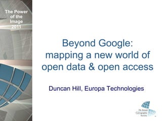
  • 1. The Power of the Image 2011 Beyond Google: mapping a new world of open data & open access Duncan Hill, Europa Technologies
  • 2. The Power of the Image Or... 2011 “I want something like Google Maps, but using OS data”
  • 3. The Power of the Image Overview 2011 • Where it all began • What‟s possible today • What we can learn from this • How we can create our own basemaps • ...and make these accessible
  • 4. The Power of the Image MapQuest launched 1996 2011
  • 5. The Power of the Image Google Maps, today 2011
  • 6. The Power of the Image Bing Maps 2011
  • 7. The Power of the Image Google Maps API Styled Maps 2011
  • 8. The Power of the Image What people like / expect 2011 • „Slippy‟ map interface • Very fast drawing speeds • Drill down for more detail • High quality cartography • Multi-platform support
  • 9. The Power of the Image Map tiles 2011
  • 10. The Power of the Image Why use map tiles? 2011 • Pre-render for optimal performance • Reserve server resources for dynamic data • Merge tile layers on request for flexibility • Subtle cartographic effects • Accessible colour palette • Easy to use • Variety of hosting options
  • 11. The Power of the Image Considerations 2011 • Time required to perfect cartography • Rendering process very resource hungry • Not quick to produce a completely new output • Vectors still required for small % of users performing data capture
  • 12. The Power of the Image How will users consume maps? 2011 • Desktop mapping applications • Public facing web applications • Intranet mapping applications • Mobile (massive growth ahead)
  • 13. The Power of the Image Why wouldn‟t you use Google? 2011 • Need more detail • Need greater accuracy • Need cartographic subtlety • Complex technology landscape • Licensing? • “I want something that looks like Google Maps, but uses OS data”
  • 14. The Power of the Image PSMA 2011 • Public Sector Mapping Agreement • 10 year agreement • Public sector bodies in England & Wales • GB coverage, free at point of use • Allows data sharing
  • 15. The Power of the Image PSMA products 2011 • OS MasterMap Topography Layer • OS MasterMap Integrated Transport Network • 1:10,000 raster (until 31 March 2013) • OS VectorMap Local • 1:25,000 raster • 1:50,000 raster • Code-Point • Code-Point with Polygons • OS OpenData • National Address Gazetteer
  • 16. The Power of the Image Our workflow 2011 Prepare Import Render & Style
  • 17. The Power of the Image viaEuropa 2011
  • 18. The Power of the Image viaEuropa 2011
  • 19. The Power of the Image viaEuropa 2011
  • 20. The Power of the Image Examples 2011 • OpenLayers • Bing Maps • Google Maps • ESRI Silverlight API • MapInfo Professional/ProViewer • ArcGIS Desktop • Cadcorp
  • 21. The Power of the Image Universal access 2011 • Support for those with a colour vision deficiency • 1 in 12 males • 1 in 100 females • Build accessibility in from outset • Avoid extra time & costs later
  • 22. The Power of the Image Universal access 2011 Contains Ordnance Survey data © Crown copyright and database right 2010
  • 23. The Power of the Image Universal access 2011 Contains Ordnance Survey data © Crown copyright and database right 2010
  • 24. The Power of the Image Universal access 2011 Contains Ordnance Survey data © Crown copyright and database right 2010
  • 25. The Power of the Image Universal access 2011 Contains Ordnance Survey data © Crown copyright and database right 2010
  • 26. The Power of the Image Summary 2011 • Consider the needs of your users • Who, why, what, when, how • Consistency across levels • Adopt a scalable approach • “Good designers decorate, great designers communicate” Cameron Moll, (Designer/Speaker/Author)
  • 27. The Power of the Image Thanks & Questions? 2011 dhill@europa.uk.com @duncanjfhill www.viaeuropa.uk.com