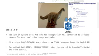
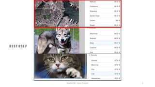
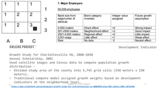
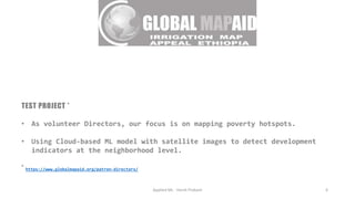
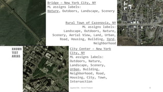
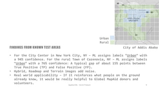
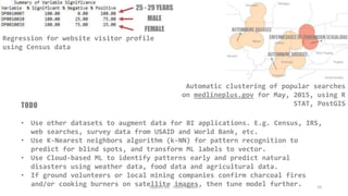
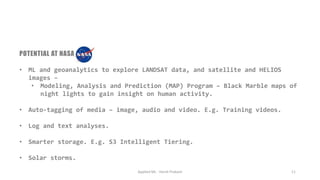
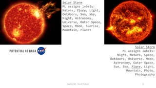
SlideShare a Scribd company logo
I N T R O
All-hands Knowledge-sharing Lunch!
• This month's session is about Applied Machine Learning (ML) - a test
personal project I am working on, the reasons thereof, and the technology
underneath.
• The project uses APIs from Cloud vendors to sift through satellite images.
• The goal today is to start a discussion around Emerging Tech at NASA.
Applied ML - Harsh Prakash 1
Applied ML - Harsh Prakash 2
W H A T I S M L ?
• ML, a subset of AI and a superset of DL, enables a user to perform
specific tasks, like predicting outcomes and recognizing images, without
explicit instructions by analyzing and learning from data based on
patterns and inference, and with minimal human intervention.
• NLP, a subset of AI, helps a user read, analyze, interpret and understand
natural language data, and perform speech recognition.
• AI helps a user’s computer systems learn (acquire data and the rules
governing its use), reason (reach conclusions), problem-solve and self-
correct to inform its decisions.
• Neural Network is at the heart - Designed to recognize patterns (variables
that rise and fall together).
L I V E D E M O *
• Web app on Apache uses AWS SDK for Rekognition API connected to a video
camera for near real-time image analysis.
• ML assigns LABELS/TAGS, and returns raw JSON response from the Model API.
• Can adjust MAXLABELS, MINCONFIDENCE, etc., be ported to Lambda/S3 Bucket,
and send alerts.
* Service currently available in AWS GovCloud (US-West) only.
Applied ML - Harsh Prakash 3
Applied ML - Harsh Prakash 4
B E S T U S E ?
Applied ML - Harsh Prakash 5
COLLEGE PROJECT *
Growth Study for Charlottesville VA, 2000-2030
Annual Scholarship, 2001
Used satellite images and Census data to compute population growth
distribution –
• Divided study area of the county into 5,745 grid cells (250 meters x 250
meters).
• Traditional compute model assigned growth weights based on development
indicators at the neighborhood level.
* https://www.slideshare.net/gisblog/gis-growth-study-for-charlottesville-va-20002030-plan-885-vamlis-2001-38716260
Development Indicator
TEST PROJECT *
• As volunteer Directors, our focus is on mapping poverty hotspots.
• Using Cloud-based ML model with satellite images to detect development
indicators at the neighborhood level.
* https://www.globalmapaid.org/patron-directors/
Applied ML - Harsh Prakash 6
STEPS
1. Opened account with Google Cloud Platform (GCP).
2. Enabled Google Maps API for project.
3. Enabled billing for project to fetch more than 1 satellite image per day
using API key.
4. Tuning model for known test areas. E.g. New York...
• Using satellite images for Ethiopia’s capital, Addis Ababa, from Google
Maps API at their highest available resolution (zoom: 17, or 1x1 sq.
mile).
• Using Cloud-based ML model to classify satellite images by infrastructure
levels.
• Assuming correlation between infrastructure and visual indicators in
satellite images.
Applied ML - Harsh Prakash 7
Bridge – New York City, NY
ML assigns labels:
Nature, Outdoors, Landscape, Scenery
Applied ML - Harsh Prakash 8
City Center – New York
City, NY
ML assigns labels:
Outdoors, Nature,
Landscape, Scenery,
Urban, Building,
Neighborhood, Road,
Housing, City, Town,
Intersection
Rural Town of Cazenovia, NY
ML assigns labels:
Landscape, Outdoors, Nature,
Scenery, Aerial View, Land, Urban,
Road, Housing, Building, Yard,
Neighborhood
KNOWN
TEST
AREAS
FINDINGS FROM KNOWN TEST AREAS
• For the City Center in New York City, NY – ML assigns labels “Urban” with
a 94% confidence. For the rural Town of Cazenovia, NY – ML assigns labels
“Urban” with a 76% confidence: A typical gap of about 15% points between
True Positive (TP) and False Positive (FP).
• Hybrid, Roadmap and Terrain images add noise.
• Real world applicability – If it reinforces what people on the ground
already know, it would be really helpful to Global MapAid donors and
volunteers. Applied ML - Harsh Prakash 9
Urban
Rural
City of Addis Ababa
TODO
• Use other datasets to augment data for BI applications. E.g. Census, IRS,
web searches, survey data from USAID and World Bank, etc.
• Use K-Nearest neighbors algorithm (k-NN) for pattern recognition to
predict for blind spots, and transform ML labels to vector.
• Use Cloud-based ML to identify patterns early and predict natural
disasters using weather data, food data and agricultural data.
• If ground volunteers or local mining companies confirm charcoal fires
and/or cooking burners on satellite images, then tune model further.Applied ML - Harsh Prakash 10
Regression for website visitor profile
using Census data
Automatic clustering of popular searches
on medlineplus.gov for May, 2015, using R
STAT, PostGIS
Applied ML - Harsh Prakash 11
POTENTIAL AT NASA
• ML and geoanalytics to explore LANDSAT data, and satellite and HELIOS
images –
• Modeling, Analysis and Prediction (MAP) Program – Black Marble maps of
night lights to gain insight on human activity.
• Auto-tagging of media – image, audio and video. E.g. Training videos.
• Log and text analyses.
• Smarter storage. E.g. S3 Intelligent Tiering.
• Solar storms.
Applied ML - Harsh Prakash 12
POTENTIAL AT NASA
Solar Storm
ML assigns labels:
Nature, Flare, Light,
Outdoors, Sun, Sky,
Night, Astronomy,
Universe, Outer Space,
Space, Moon, Sunrise,
Mountain, Planet
Solar Storm
ML assigns labels:
Night, Nature, Space,
Outdoors, Universe, Moon,
Astronomy, Outer Space,
Sun, Sky, Flare, Light,
Mountain, Photo,
Photography
NEXT STEPS
• Model as a Service – ML Models on AWS Marketplace.
• Frameworks and Tools – Rekognition, Google Vision, Microsoft Computer
Vision, TensorFlow, PyTorch, Jupyter Notebook, AWS SageMaker, R STAT.
• Questions?
Applied ML - Harsh Prakash 13
This
presentation’s
word cloud

More Related Content

What's hot

Geographic information system
Geographic information systemGeographic information system
Geographic information system
Dhaval Jalalpara
 
The Application of GIS in Urban Planning
The Application of GIS in Urban PlanningThe Application of GIS in Urban Planning
The Application of GIS in Urban Planning
agungwah
 
Application of GIS (Geographical information system)
Application of GIS (Geographical information system)Application of GIS (Geographical information system)
Application of GIS (Geographical information system)
Fayaz Ahamed A P
 
Fundamentals of gis
Fundamentals of gisFundamentals of gis
Fundamentals of gis
Ayman Elkhatip
 
Introduction To GIS
Introduction To GISIntroduction To GIS
Introduction To GIS
Maneesh Prasad
 
A Journey to the World of GIS
A Journey to the World of GISA Journey to the World of GIS
A Journey to the World of GIS
Nishant Sinha
 
Case study of goggle map
Case study of goggle mapCase study of goggle map
Case study of goggle map
Suraksha Sanghavi
 
Why and how to scrape geospatial data from the web
Why and how to scrape geospatial data from the webWhy and how to scrape geospatial data from the web
Why and how to scrape geospatial data from the web
PromptCloud
 
Crowd-Sourcing Approach of Building Ground Truth Database for Global Urban Ar...
Crowd-Sourcing Approach of Building Ground Truth Database for Global Urban Ar...Crowd-Sourcing Approach of Building Ground Truth Database for Global Urban Ar...
Crowd-Sourcing Approach of Building Ground Truth Database for Global Urban Ar...
Hiroyuki Miyazaki
 
Geographic Information Systems in the Oil & Gas Industry
Geographic Information Systems in the Oil & Gas IndustryGeographic Information Systems in the Oil & Gas Industry
Geographic Information Systems in the Oil & Gas Industry
Francois Viljoen
 
Spatial analysis and modelling of bicycle accidents and safety threats
Spatial analysis and modelling of bicycle accidents and safety threatsSpatial analysis and modelling of bicycle accidents and safety threats
Spatial analysis and modelling of bicycle accidents and safety threats
Martin L
 
Geographic information system
Geographic information systemGeographic information system
Geographic information system
Sumanta Das
 
Lect 1 & 2 introduction to gis & rs
Lect 1 & 2  introduction to gis & rsLect 1 & 2  introduction to gis & rs
Lect 1 & 2 introduction to gis & rs
Rehana Jamal
 
Big Data - Big Insights - Waze @Google
Big Data - Big Insights - Waze @GoogleBig Data - Big Insights - Waze @Google
Big Data - Big Insights - Waze @Google
Daniel Marcous
 
Big data, open data and telepathy: technologies for smart, human-scale cities...
Big data, open data and telepathy: technologies for smart, human-scale cities...Big data, open data and telepathy: technologies for smart, human-scale cities...
Big data, open data and telepathy: technologies for smart, human-scale cities...
Rick Robinson
 
GIS
GISGIS
What is GIS?
What is GIS?What is GIS?
What is GIS?
Daniel Demonceau
 
Spatial Computing and the Future of Utility GIS
Spatial Computing and the Future of Utility GISSpatial Computing and the Future of Utility GIS
Spatial Computing and the Future of Utility GIS
George Percivall
 
What is Geography Information Systems (GIS)
What is Geography Information Systems (GIS)What is Geography Information Systems (GIS)
What is Geography Information Systems (GIS)
John Lanser
 
GIS
GISGIS

What's hot (20)

Geographic information system
Geographic information systemGeographic information system
Geographic information system
 
The Application of GIS in Urban Planning
The Application of GIS in Urban PlanningThe Application of GIS in Urban Planning
The Application of GIS in Urban Planning
 
Application of GIS (Geographical information system)
Application of GIS (Geographical information system)Application of GIS (Geographical information system)
Application of GIS (Geographical information system)
 
Fundamentals of gis
Fundamentals of gisFundamentals of gis
Fundamentals of gis
 
Introduction To GIS
Introduction To GISIntroduction To GIS
Introduction To GIS
 
A Journey to the World of GIS
A Journey to the World of GISA Journey to the World of GIS
A Journey to the World of GIS
 
Case study of goggle map
Case study of goggle mapCase study of goggle map
Case study of goggle map
 
Why and how to scrape geospatial data from the web
Why and how to scrape geospatial data from the webWhy and how to scrape geospatial data from the web
Why and how to scrape geospatial data from the web
 
Crowd-Sourcing Approach of Building Ground Truth Database for Global Urban Ar...
Crowd-Sourcing Approach of Building Ground Truth Database for Global Urban Ar...Crowd-Sourcing Approach of Building Ground Truth Database for Global Urban Ar...
Crowd-Sourcing Approach of Building Ground Truth Database for Global Urban Ar...
 
Geographic Information Systems in the Oil & Gas Industry
Geographic Information Systems in the Oil & Gas IndustryGeographic Information Systems in the Oil & Gas Industry
Geographic Information Systems in the Oil & Gas Industry
 
Spatial analysis and modelling of bicycle accidents and safety threats
Spatial analysis and modelling of bicycle accidents and safety threatsSpatial analysis and modelling of bicycle accidents and safety threats
Spatial analysis and modelling of bicycle accidents and safety threats
 
Geographic information system
Geographic information systemGeographic information system
Geographic information system
 
Lect 1 & 2 introduction to gis & rs
Lect 1 & 2  introduction to gis & rsLect 1 & 2  introduction to gis & rs
Lect 1 & 2 introduction to gis & rs
 
Big Data - Big Insights - Waze @Google
Big Data - Big Insights - Waze @GoogleBig Data - Big Insights - Waze @Google
Big Data - Big Insights - Waze @Google
 
Big data, open data and telepathy: technologies for smart, human-scale cities...
Big data, open data and telepathy: technologies for smart, human-scale cities...Big data, open data and telepathy: technologies for smart, human-scale cities...
Big data, open data and telepathy: technologies for smart, human-scale cities...
 
GIS
GISGIS
GIS
 
What is GIS?
What is GIS?What is GIS?
What is GIS?
 
Spatial Computing and the Future of Utility GIS
Spatial Computing and the Future of Utility GISSpatial Computing and the Future of Utility GIS
Spatial Computing and the Future of Utility GIS
 
What is Geography Information Systems (GIS)
What is Geography Information Systems (GIS)What is Geography Information Systems (GIS)
What is Geography Information Systems (GIS)
 
GIS
GISGIS
GIS
 

Similar to Applied ML (Machine Learning)

NASA Data Science Day Plenary: Applied Machine Learning (ML)
NASA Data Science Day Plenary: Applied Machine Learning (ML)NASA Data Science Day Plenary: Applied Machine Learning (ML)
NASA Data Science Day Plenary: Applied Machine Learning (ML)
Harsh Prakash (AWS, Azure, Security+, Agile, PMP, GISP)
 
understanding the planet using satellites and deep learning
understanding the planet using satellites and deep learningunderstanding the planet using satellites and deep learning
understanding the planet using satellites and deep learning
Albert Pujol Torras
 
Pathways Overview For Open House 19 Sep2010
Pathways Overview For Open House   19 Sep2010Pathways Overview For Open House   19 Sep2010
Pathways Overview For Open House 19 Sep2010
jmorriso
 
environmental scivis via dynamic and thematc mapping
environmental scivis via dynamic and thematc mappingenvironmental scivis via dynamic and thematc mapping
environmental scivis via dynamic and thematc mapping
Neale Misquitta
 
Poster
PosterPoster
What is a Data Commons and Why Should You Care?
What is a Data Commons and Why Should You Care? What is a Data Commons and Why Should You Care?
What is a Data Commons and Why Should You Care?
Robert Grossman
 
6 Common Mistakes to Avoid When Using Utility Mapping Solution
6 Common Mistakes to Avoid When Using Utility Mapping Solution6 Common Mistakes to Avoid When Using Utility Mapping Solution
6 Common Mistakes to Avoid When Using Utility Mapping Solution
OcuMap
 
Rachith resume
Rachith resumeRachith resume
Rachith resume
RachithRamaswamy
 
Crowd sourced intelligence built into search over hadoop
Crowd sourced intelligence built into search over hadoopCrowd sourced intelligence built into search over hadoop
Crowd sourced intelligence built into search over hadoop
lucenerevolution
 
20181128 satellogic @ barcelona ai
20181128 satellogic @ barcelona ai20181128 satellogic @ barcelona ai
20181128 satellogic @ barcelona ai
Albert Pujol Torras
 
slam_research_paper
slam_research_paperslam_research_paper
slam_research_paper
Vinit Payal
 
Geospatial Analytics at Scale with Deep Learning and Apache Spark
Geospatial Analytics at Scale with Deep Learning and Apache SparkGeospatial Analytics at Scale with Deep Learning and Apache Spark
Geospatial Analytics at Scale with Deep Learning and Apache Spark
Databricks
 
cv_for_PROCESS
cv_for_PROCESScv_for_PROCESS
cv_for_PROCESS
Qionghui Zhang
 
Graph Based Machine Learning with Applications to Media Analytics
Graph Based Machine Learning with Applications to Media AnalyticsGraph Based Machine Learning with Applications to Media Analytics
Graph Based Machine Learning with Applications to Media Analytics
NYC Predictive Analytics
 
SolarInitiative_Paper
SolarInitiative_PaperSolarInitiative_Paper
SolarInitiative_Paper
Erin Reynolds
 
MYashar_UCB_BIDS
MYashar_UCB_BIDSMYashar_UCB_BIDS
MYashar_UCB_BIDS
Mark Yashar
 
Survey on Location Based Recommendation System Using POI
Survey on Location Based Recommendation System Using POISurvey on Location Based Recommendation System Using POI
Survey on Location Based Recommendation System Using POI
IRJET Journal
 
Information Visualization: Analyzing and Presenting Data
Information Visualization: Analyzing and Presenting DataInformation Visualization: Analyzing and Presenting Data
Information Visualization: Analyzing and Presenting Data
Andrew Vande Moere
 
Orchestrating Collective Intelligence
Orchestrating Collective IntelligenceOrchestrating Collective Intelligence
Orchestrating Collective Intelligence
Turi, Inc.
 
Integrating eo with official statistics using machine learning in mexico geo ...
Integrating eo with official statistics using machine learning in mexico geo ...Integrating eo with official statistics using machine learning in mexico geo ...
Integrating eo with official statistics using machine learning in mexico geo ...
Abel Alejandro Coronado Iruegas
 

Similar to Applied ML (Machine Learning) (20)

NASA Data Science Day Plenary: Applied Machine Learning (ML)
NASA Data Science Day Plenary: Applied Machine Learning (ML)NASA Data Science Day Plenary: Applied Machine Learning (ML)
NASA Data Science Day Plenary: Applied Machine Learning (ML)
 
understanding the planet using satellites and deep learning
understanding the planet using satellites and deep learningunderstanding the planet using satellites and deep learning
understanding the planet using satellites and deep learning
 
Pathways Overview For Open House 19 Sep2010
Pathways Overview For Open House   19 Sep2010Pathways Overview For Open House   19 Sep2010
Pathways Overview For Open House 19 Sep2010
 
environmental scivis via dynamic and thematc mapping
environmental scivis via dynamic and thematc mappingenvironmental scivis via dynamic and thematc mapping
environmental scivis via dynamic and thematc mapping
 
Poster
PosterPoster
Poster
 
What is a Data Commons and Why Should You Care?
What is a Data Commons and Why Should You Care? What is a Data Commons and Why Should You Care?
What is a Data Commons and Why Should You Care?
 
6 Common Mistakes to Avoid When Using Utility Mapping Solution
6 Common Mistakes to Avoid When Using Utility Mapping Solution6 Common Mistakes to Avoid When Using Utility Mapping Solution
6 Common Mistakes to Avoid When Using Utility Mapping Solution
 
Rachith resume
Rachith resumeRachith resume
Rachith resume
 
Crowd sourced intelligence built into search over hadoop
Crowd sourced intelligence built into search over hadoopCrowd sourced intelligence built into search over hadoop
Crowd sourced intelligence built into search over hadoop
 
20181128 satellogic @ barcelona ai
20181128 satellogic @ barcelona ai20181128 satellogic @ barcelona ai
20181128 satellogic @ barcelona ai
 
slam_research_paper
slam_research_paperslam_research_paper
slam_research_paper
 
Geospatial Analytics at Scale with Deep Learning and Apache Spark
Geospatial Analytics at Scale with Deep Learning and Apache SparkGeospatial Analytics at Scale with Deep Learning and Apache Spark
Geospatial Analytics at Scale with Deep Learning and Apache Spark
 
cv_for_PROCESS
cv_for_PROCESScv_for_PROCESS
cv_for_PROCESS
 
Graph Based Machine Learning with Applications to Media Analytics
Graph Based Machine Learning with Applications to Media AnalyticsGraph Based Machine Learning with Applications to Media Analytics
Graph Based Machine Learning with Applications to Media Analytics
 
SolarInitiative_Paper
SolarInitiative_PaperSolarInitiative_Paper
SolarInitiative_Paper
 
MYashar_UCB_BIDS
MYashar_UCB_BIDSMYashar_UCB_BIDS
MYashar_UCB_BIDS
 
Survey on Location Based Recommendation System Using POI
Survey on Location Based Recommendation System Using POISurvey on Location Based Recommendation System Using POI
Survey on Location Based Recommendation System Using POI
 
Information Visualization: Analyzing and Presenting Data
Information Visualization: Analyzing and Presenting DataInformation Visualization: Analyzing and Presenting Data
Information Visualization: Analyzing and Presenting Data
 
Orchestrating Collective Intelligence
Orchestrating Collective IntelligenceOrchestrating Collective Intelligence
Orchestrating Collective Intelligence
 
Integrating eo with official statistics using machine learning in mexico geo ...
Integrating eo with official statistics using machine learning in mexico geo ...Integrating eo with official statistics using machine learning in mexico geo ...
Integrating eo with official statistics using machine learning in mexico geo ...
 

More from Harsh Prakash (AWS, Azure, Security+, Agile, PMP, GISP)

Model Optimal Drilling Location (MODL)
Model Optimal Drilling Location (MODL)Model Optimal Drilling Location (MODL)
Model Optimal Drilling Location (MODL)
Harsh Prakash (AWS, Azure, Security+, Agile, PMP, GISP)
 
Esri ArcGIS Federal
Esri ArcGIS FederalEsri ArcGIS Federal
Esri WebGIS Platform
Esri WebGIS PlatformEsri WebGIS Platform
Esri in AWS Cloud
Esri in AWS CloudEsri in AWS Cloud
Geodata Based Decisions
Geodata Based DecisionsGeodata Based Decisions
GIS Planning - Using GIS for County Multi-Hazard Mitigation Plan (HMP)
GIS Planning - Using GIS for County Multi-Hazard Mitigation Plan (HMP)GIS Planning - Using GIS for County Multi-Hazard Mitigation Plan (HMP)
GIS Planning - Using GIS for County Multi-Hazard Mitigation Plan (HMP)
Harsh Prakash (AWS, Azure, Security+, Agile, PMP, GISP)
 
GIS Market Study of Internet Mapping Server (IMS) - Summary - Requirements an...
GIS Market Study of Internet Mapping Server (IMS) - Summary - Requirements an...GIS Market Study of Internet Mapping Server (IMS) - Summary - Requirements an...
GIS Market Study of Internet Mapping Server (IMS) - Summary - Requirements an...
Harsh Prakash (AWS, Azure, Security+, Agile, PMP, GISP)
 
3D GIS - Using ESRI 3D Analyst & ESRI ArcScene for Visualization
3D GIS - Using ESRI 3D Analyst & ESRI ArcScene for Visualization3D GIS - Using ESRI 3D Analyst & ESRI ArcScene for Visualization
3D GIS - Using ESRI 3D Analyst & ESRI ArcScene for Visualization
Harsh Prakash (AWS, Azure, Security+, Agile, PMP, GISP)
 
Report on Options for Division Webinars - Final (Version 7) - APA - DC - EC (11)
Report on Options for Division Webinars - Final (Version 7) - APA - DC - EC (11)Report on Options for Division Webinars - Final (Version 7) - APA - DC - EC (11)
Report on Options for Division Webinars - Final (Version 7) - APA - DC - EC (11)
Harsh Prakash (AWS, Azure, Security+, Agile, PMP, GISP)
 
Performance Report - APA Technology Division (12)
Performance Report - APA Technology Division (12)Performance Report - APA Technology Division (12)
Performance Report - APA Technology Division (12)
Harsh Prakash (AWS, Azure, Security+, Agile, PMP, GISP)
 
GIS Growth Study for Charlottesville VA - 2000-2030 (PLAN 885) - VAMLIS
GIS Growth Study for Charlottesville VA - 2000-2030 (PLAN 885) - VAMLISGIS Growth Study for Charlottesville VA - 2000-2030 (PLAN 885) - VAMLIS
GIS Growth Study for Charlottesville VA - 2000-2030 (PLAN 885) - VAMLIS
Harsh Prakash (AWS, Azure, Security+, Agile, PMP, GISP)
 
GIS TECH 201 - Mapping Mashups
GIS TECH 201 - Mapping MashupsGIS TECH 201 - Mapping Mashups
GIS TECH 101 - Mapping Mashups
GIS TECH 101 - Mapping MashupsGIS TECH 101 - Mapping Mashups

More from Harsh Prakash (AWS, Azure, Security+, Agile, PMP, GISP) (13)

Model Optimal Drilling Location (MODL)
Model Optimal Drilling Location (MODL)Model Optimal Drilling Location (MODL)
Model Optimal Drilling Location (MODL)
 
Esri ArcGIS Federal
Esri ArcGIS FederalEsri ArcGIS Federal
Esri ArcGIS Federal
 
Esri WebGIS Platform
Esri WebGIS PlatformEsri WebGIS Platform
Esri WebGIS Platform
 
Esri in AWS Cloud
Esri in AWS CloudEsri in AWS Cloud
Esri in AWS Cloud
 
Geodata Based Decisions
Geodata Based DecisionsGeodata Based Decisions
Geodata Based Decisions
 
GIS Planning - Using GIS for County Multi-Hazard Mitigation Plan (HMP)
GIS Planning - Using GIS for County Multi-Hazard Mitigation Plan (HMP)GIS Planning - Using GIS for County Multi-Hazard Mitigation Plan (HMP)
GIS Planning - Using GIS for County Multi-Hazard Mitigation Plan (HMP)
 
GIS Market Study of Internet Mapping Server (IMS) - Summary - Requirements an...
GIS Market Study of Internet Mapping Server (IMS) - Summary - Requirements an...GIS Market Study of Internet Mapping Server (IMS) - Summary - Requirements an...
GIS Market Study of Internet Mapping Server (IMS) - Summary - Requirements an...
 
3D GIS - Using ESRI 3D Analyst & ESRI ArcScene for Visualization
3D GIS - Using ESRI 3D Analyst & ESRI ArcScene for Visualization3D GIS - Using ESRI 3D Analyst & ESRI ArcScene for Visualization
3D GIS - Using ESRI 3D Analyst & ESRI ArcScene for Visualization
 
Report on Options for Division Webinars - Final (Version 7) - APA - DC - EC (11)
Report on Options for Division Webinars - Final (Version 7) - APA - DC - EC (11)Report on Options for Division Webinars - Final (Version 7) - APA - DC - EC (11)
Report on Options for Division Webinars - Final (Version 7) - APA - DC - EC (11)
 
Performance Report - APA Technology Division (12)
Performance Report - APA Technology Division (12)Performance Report - APA Technology Division (12)
Performance Report - APA Technology Division (12)
 
GIS Growth Study for Charlottesville VA - 2000-2030 (PLAN 885) - VAMLIS
GIS Growth Study for Charlottesville VA - 2000-2030 (PLAN 885) - VAMLISGIS Growth Study for Charlottesville VA - 2000-2030 (PLAN 885) - VAMLIS
GIS Growth Study for Charlottesville VA - 2000-2030 (PLAN 885) - VAMLIS
 
GIS TECH 201 - Mapping Mashups
GIS TECH 201 - Mapping MashupsGIS TECH 201 - Mapping Mashups
GIS TECH 201 - Mapping Mashups
 
GIS TECH 101 - Mapping Mashups
GIS TECH 101 - Mapping MashupsGIS TECH 101 - Mapping Mashups
GIS TECH 101 - Mapping Mashups
 

Recently uploaded

Recommendation System using RAG Architecture
Recommendation System using RAG ArchitectureRecommendation System using RAG Architecture
Recommendation System using RAG Architecture
fredae14
 
Choosing The Best AWS Service For Your Website + API.pptx
Choosing The Best AWS Service For Your Website + API.pptxChoosing The Best AWS Service For Your Website + API.pptx
Choosing The Best AWS Service For Your Website + API.pptx
Brandon Minnick, MBA
 
Programming Foundation Models with DSPy - Meetup Slides
Programming Foundation Models with DSPy - Meetup SlidesProgramming Foundation Models with DSPy - Meetup Slides
Programming Foundation Models with DSPy - Meetup Slides
Zilliz
 
Operating System Used by Users in day-to-day life.pptx
Operating System Used by Users in day-to-day life.pptxOperating System Used by Users in day-to-day life.pptx
Operating System Used by Users in day-to-day life.pptx
Pravash Chandra Das
 
Trusted Execution Environment for Decentralized Process Mining
Trusted Execution Environment for Decentralized Process MiningTrusted Execution Environment for Decentralized Process Mining
Trusted Execution Environment for Decentralized Process Mining
LucaBarbaro3
 
Main news related to the CCS TSI 2023 (2023/1695)
Main news related to the CCS TSI 2023 (2023/1695)Main news related to the CCS TSI 2023 (2023/1695)
Main news related to the CCS TSI 2023 (2023/1695)
Jakub Marek
 
Deep Dive: AI-Powered Marketing to Get More Leads and Customers with HyperGro...
Deep Dive: AI-Powered Marketing to Get More Leads and Customers with HyperGro...Deep Dive: AI-Powered Marketing to Get More Leads and Customers with HyperGro...
Deep Dive: AI-Powered Marketing to Get More Leads and Customers with HyperGro...
saastr
 
Ocean lotus Threat actors project by John Sitima 2024 (1).pptx
Ocean lotus Threat actors project by John Sitima 2024 (1).pptxOcean lotus Threat actors project by John Sitima 2024 (1).pptx
Ocean lotus Threat actors project by John Sitima 2024 (1).pptx
SitimaJohn
 
Skybuffer AI: Advanced Conversational and Generative AI Solution on SAP Busin...
Skybuffer AI: Advanced Conversational and Generative AI Solution on SAP Busin...Skybuffer AI: Advanced Conversational and Generative AI Solution on SAP Busin...
Skybuffer AI: Advanced Conversational and Generative AI Solution on SAP Busin...
Tatiana Kojar
 
Serial Arm Control in Real Time Presentation
Serial Arm Control in Real Time PresentationSerial Arm Control in Real Time Presentation
Serial Arm Control in Real Time Presentation
tolgahangng
 
Columbus Data & Analytics Wednesdays - June 2024
Columbus Data & Analytics Wednesdays - June 2024Columbus Data & Analytics Wednesdays - June 2024
Columbus Data & Analytics Wednesdays - June 2024
Jason Packer
 
Digital Marketing Trends in 2024 | Guide for Staying Ahead
Digital Marketing Trends in 2024 | Guide for Staying AheadDigital Marketing Trends in 2024 | Guide for Staying Ahead
Digital Marketing Trends in 2024 | Guide for Staying Ahead
Wask
 
TrustArc Webinar - 2024 Global Privacy Survey
TrustArc Webinar - 2024 Global Privacy SurveyTrustArc Webinar - 2024 Global Privacy Survey
TrustArc Webinar - 2024 Global Privacy Survey
TrustArc
 
Deep Dive: Getting Funded with Jason Jason Lemkin Founder & CEO @ SaaStr
Deep Dive: Getting Funded with Jason Jason Lemkin Founder & CEO @ SaaStrDeep Dive: Getting Funded with Jason Jason Lemkin Founder & CEO @ SaaStr
Deep Dive: Getting Funded with Jason Jason Lemkin Founder & CEO @ SaaStr
saastr
 
June Patch Tuesday
June Patch TuesdayJune Patch Tuesday
June Patch Tuesday
Ivanti
 
Monitoring and Managing Anomaly Detection on OpenShift.pdf
Monitoring and Managing Anomaly Detection on OpenShift.pdfMonitoring and Managing Anomaly Detection on OpenShift.pdf
Monitoring and Managing Anomaly Detection on OpenShift.pdf
Tosin Akinosho
 
Building Production Ready Search Pipelines with Spark and Milvus
Building Production Ready Search Pipelines with Spark and MilvusBuilding Production Ready Search Pipelines with Spark and Milvus
Building Production Ready Search Pipelines with Spark and Milvus
Zilliz
 
GenAI Pilot Implementation in the organizations
GenAI Pilot Implementation in the organizationsGenAI Pilot Implementation in the organizations
GenAI Pilot Implementation in the organizations
kumardaparthi1024
 
Introduction of Cybersecurity with OSS at Code Europe 2024
Introduction of Cybersecurity with OSS  at Code Europe 2024Introduction of Cybersecurity with OSS  at Code Europe 2024
Introduction of Cybersecurity with OSS at Code Europe 2024
Hiroshi SHIBATA
 
GraphRAG for Life Science to increase LLM accuracy
GraphRAG for Life Science to increase LLM accuracyGraphRAG for Life Science to increase LLM accuracy
GraphRAG for Life Science to increase LLM accuracy
Tomaz Bratanic
 

Recently uploaded (20)

Recommendation System using RAG Architecture
Recommendation System using RAG ArchitectureRecommendation System using RAG Architecture
Recommendation System using RAG Architecture
 
Choosing The Best AWS Service For Your Website + API.pptx
Choosing The Best AWS Service For Your Website + API.pptxChoosing The Best AWS Service For Your Website + API.pptx
Choosing The Best AWS Service For Your Website + API.pptx
 
Programming Foundation Models with DSPy - Meetup Slides
Programming Foundation Models with DSPy - Meetup SlidesProgramming Foundation Models with DSPy - Meetup Slides
Programming Foundation Models with DSPy - Meetup Slides
 
Operating System Used by Users in day-to-day life.pptx
Operating System Used by Users in day-to-day life.pptxOperating System Used by Users in day-to-day life.pptx
Operating System Used by Users in day-to-day life.pptx
 
Trusted Execution Environment for Decentralized Process Mining
Trusted Execution Environment for Decentralized Process MiningTrusted Execution Environment for Decentralized Process Mining
Trusted Execution Environment for Decentralized Process Mining
 
Main news related to the CCS TSI 2023 (2023/1695)
Main news related to the CCS TSI 2023 (2023/1695)Main news related to the CCS TSI 2023 (2023/1695)
Main news related to the CCS TSI 2023 (2023/1695)
 
Deep Dive: AI-Powered Marketing to Get More Leads and Customers with HyperGro...
Deep Dive: AI-Powered Marketing to Get More Leads and Customers with HyperGro...Deep Dive: AI-Powered Marketing to Get More Leads and Customers with HyperGro...
Deep Dive: AI-Powered Marketing to Get More Leads and Customers with HyperGro...
 
Ocean lotus Threat actors project by John Sitima 2024 (1).pptx
Ocean lotus Threat actors project by John Sitima 2024 (1).pptxOcean lotus Threat actors project by John Sitima 2024 (1).pptx
Ocean lotus Threat actors project by John Sitima 2024 (1).pptx
 
Skybuffer AI: Advanced Conversational and Generative AI Solution on SAP Busin...
Skybuffer AI: Advanced Conversational and Generative AI Solution on SAP Busin...Skybuffer AI: Advanced Conversational and Generative AI Solution on SAP Busin...
Skybuffer AI: Advanced Conversational and Generative AI Solution on SAP Busin...
 
Serial Arm Control in Real Time Presentation
Serial Arm Control in Real Time PresentationSerial Arm Control in Real Time Presentation
Serial Arm Control in Real Time Presentation
 
Columbus Data & Analytics Wednesdays - June 2024
Columbus Data & Analytics Wednesdays - June 2024Columbus Data & Analytics Wednesdays - June 2024
Columbus Data & Analytics Wednesdays - June 2024
 
Digital Marketing Trends in 2024 | Guide for Staying Ahead
Digital Marketing Trends in 2024 | Guide for Staying AheadDigital Marketing Trends in 2024 | Guide for Staying Ahead
Digital Marketing Trends in 2024 | Guide for Staying Ahead
 
TrustArc Webinar - 2024 Global Privacy Survey
TrustArc Webinar - 2024 Global Privacy SurveyTrustArc Webinar - 2024 Global Privacy Survey
TrustArc Webinar - 2024 Global Privacy Survey
 
Deep Dive: Getting Funded with Jason Jason Lemkin Founder & CEO @ SaaStr
Deep Dive: Getting Funded with Jason Jason Lemkin Founder & CEO @ SaaStrDeep Dive: Getting Funded with Jason Jason Lemkin Founder & CEO @ SaaStr
Deep Dive: Getting Funded with Jason Jason Lemkin Founder & CEO @ SaaStr
 
June Patch Tuesday
June Patch TuesdayJune Patch Tuesday
June Patch Tuesday
 
Monitoring and Managing Anomaly Detection on OpenShift.pdf
Monitoring and Managing Anomaly Detection on OpenShift.pdfMonitoring and Managing Anomaly Detection on OpenShift.pdf
Monitoring and Managing Anomaly Detection on OpenShift.pdf
 
Building Production Ready Search Pipelines with Spark and Milvus
Building Production Ready Search Pipelines with Spark and MilvusBuilding Production Ready Search Pipelines with Spark and Milvus
Building Production Ready Search Pipelines with Spark and Milvus
 
GenAI Pilot Implementation in the organizations
GenAI Pilot Implementation in the organizationsGenAI Pilot Implementation in the organizations
GenAI Pilot Implementation in the organizations
 
Introduction of Cybersecurity with OSS at Code Europe 2024
Introduction of Cybersecurity with OSS  at Code Europe 2024Introduction of Cybersecurity with OSS  at Code Europe 2024
Introduction of Cybersecurity with OSS at Code Europe 2024
 
GraphRAG for Life Science to increase LLM accuracy
GraphRAG for Life Science to increase LLM accuracyGraphRAG for Life Science to increase LLM accuracy
GraphRAG for Life Science to increase LLM accuracy
 

Applied ML (Machine Learning)

  • 1. I N T R O All-hands Knowledge-sharing Lunch! • This month's session is about Applied Machine Learning (ML) - a test personal project I am working on, the reasons thereof, and the technology underneath. • The project uses APIs from Cloud vendors to sift through satellite images. • The goal today is to start a discussion around Emerging Tech at NASA. Applied ML - Harsh Prakash 1
  • 2. Applied ML - Harsh Prakash 2 W H A T I S M L ? • ML, a subset of AI and a superset of DL, enables a user to perform specific tasks, like predicting outcomes and recognizing images, without explicit instructions by analyzing and learning from data based on patterns and inference, and with minimal human intervention. • NLP, a subset of AI, helps a user read, analyze, interpret and understand natural language data, and perform speech recognition. • AI helps a user’s computer systems learn (acquire data and the rules governing its use), reason (reach conclusions), problem-solve and self- correct to inform its decisions. • Neural Network is at the heart - Designed to recognize patterns (variables that rise and fall together).
  • 3. L I V E D E M O * • Web app on Apache uses AWS SDK for Rekognition API connected to a video camera for near real-time image analysis. • ML assigns LABELS/TAGS, and returns raw JSON response from the Model API. • Can adjust MAXLABELS, MINCONFIDENCE, etc., be ported to Lambda/S3 Bucket, and send alerts. * Service currently available in AWS GovCloud (US-West) only. Applied ML - Harsh Prakash 3
  • 4. Applied ML - Harsh Prakash 4 B E S T U S E ?
  • 5. Applied ML - Harsh Prakash 5 COLLEGE PROJECT * Growth Study for Charlottesville VA, 2000-2030 Annual Scholarship, 2001 Used satellite images and Census data to compute population growth distribution – • Divided study area of the county into 5,745 grid cells (250 meters x 250 meters). • Traditional compute model assigned growth weights based on development indicators at the neighborhood level. * https://www.slideshare.net/gisblog/gis-growth-study-for-charlottesville-va-20002030-plan-885-vamlis-2001-38716260 Development Indicator
  • 6. TEST PROJECT * • As volunteer Directors, our focus is on mapping poverty hotspots. • Using Cloud-based ML model with satellite images to detect development indicators at the neighborhood level. * https://www.globalmapaid.org/patron-directors/ Applied ML - Harsh Prakash 6
  • 7. STEPS 1. Opened account with Google Cloud Platform (GCP). 2. Enabled Google Maps API for project. 3. Enabled billing for project to fetch more than 1 satellite image per day using API key. 4. Tuning model for known test areas. E.g. New York... • Using satellite images for Ethiopia’s capital, Addis Ababa, from Google Maps API at their highest available resolution (zoom: 17, or 1x1 sq. mile). • Using Cloud-based ML model to classify satellite images by infrastructure levels. • Assuming correlation between infrastructure and visual indicators in satellite images. Applied ML - Harsh Prakash 7
  • 8. Bridge – New York City, NY ML assigns labels: Nature, Outdoors, Landscape, Scenery Applied ML - Harsh Prakash 8 City Center – New York City, NY ML assigns labels: Outdoors, Nature, Landscape, Scenery, Urban, Building, Neighborhood, Road, Housing, City, Town, Intersection Rural Town of Cazenovia, NY ML assigns labels: Landscape, Outdoors, Nature, Scenery, Aerial View, Land, Urban, Road, Housing, Building, Yard, Neighborhood KNOWN TEST AREAS
  • 9. FINDINGS FROM KNOWN TEST AREAS • For the City Center in New York City, NY – ML assigns labels “Urban” with a 94% confidence. For the rural Town of Cazenovia, NY – ML assigns labels “Urban” with a 76% confidence: A typical gap of about 15% points between True Positive (TP) and False Positive (FP). • Hybrid, Roadmap and Terrain images add noise. • Real world applicability – If it reinforces what people on the ground already know, it would be really helpful to Global MapAid donors and volunteers. Applied ML - Harsh Prakash 9 Urban Rural City of Addis Ababa
  • 10. TODO • Use other datasets to augment data for BI applications. E.g. Census, IRS, web searches, survey data from USAID and World Bank, etc. • Use K-Nearest neighbors algorithm (k-NN) for pattern recognition to predict for blind spots, and transform ML labels to vector. • Use Cloud-based ML to identify patterns early and predict natural disasters using weather data, food data and agricultural data. • If ground volunteers or local mining companies confirm charcoal fires and/or cooking burners on satellite images, then tune model further.Applied ML - Harsh Prakash 10 Regression for website visitor profile using Census data Automatic clustering of popular searches on medlineplus.gov for May, 2015, using R STAT, PostGIS
  • 11. Applied ML - Harsh Prakash 11 POTENTIAL AT NASA • ML and geoanalytics to explore LANDSAT data, and satellite and HELIOS images – • Modeling, Analysis and Prediction (MAP) Program – Black Marble maps of night lights to gain insight on human activity. • Auto-tagging of media – image, audio and video. E.g. Training videos. • Log and text analyses. • Smarter storage. E.g. S3 Intelligent Tiering. • Solar storms.
  • 12. Applied ML - Harsh Prakash 12 POTENTIAL AT NASA Solar Storm ML assigns labels: Nature, Flare, Light, Outdoors, Sun, Sky, Night, Astronomy, Universe, Outer Space, Space, Moon, Sunrise, Mountain, Planet Solar Storm ML assigns labels: Night, Nature, Space, Outdoors, Universe, Moon, Astronomy, Outer Space, Sun, Sky, Flare, Light, Mountain, Photo, Photography
  • 13. NEXT STEPS • Model as a Service – ML Models on AWS Marketplace. • Frameworks and Tools – Rekognition, Google Vision, Microsoft Computer Vision, TensorFlow, PyTorch, Jupyter Notebook, AWS SageMaker, R STAT. • Questions? Applied ML - Harsh Prakash 13 This presentation’s word cloud