SlideShare a Scribd company logo
1 of 5
Download to read offline
IOSR Journal of Computer Engineering (IOSR-JCE)
e-ISSN: 2278-0661,p-ISSN: 2278-8727, Volume 18, Issue 3, Ver. I (May-Jun.2016), PP 01-05
www.iosrjournals.org
DOI: 10.9790/0661-1803010105 www.iosrjournals.org 1 | Page
Identifying Bursty Local Areas Related To Emergency Topics
S. S. More1
, Deepak Walkar2
, Parikshit Pishte3
, Saurabh Patil4
, Ritesh Kedari5
,
Dhananjay Prabhawalkar6
S. S. More, Professor, Dept. Computer Science and Engineering, Sanjay Ghodawat Institute,
Deepak Walkar, Parikshit Pishte, Saurabh Patil, Ritesh Kedari, Dhananjay Prabhawalkar,
BE Scholars, Sanjay Ghodawat Institute, Atigre.
Abstract: As the social media has gained more attention from users on the Internet, social media has been one
of the most important information sources in the world. And, with the increasing popularity of social media,
data which is posted on social media sites are rapidly becoming popular, which is a term used to refer to new
media that is replacing traditional media. In this paper, we concentrate on geotagged tweets on the Twitter site.
These geotagged tweets are known to as georeferenced documents because they include not only a short text
message, but also have documents’ which are posting time and location. Many researchers have been handling
the development of new data mining techniques for georeferenced documents to recognize and analyze
emergency topics, such as natural disasters, weather, diseases, and other incidents. In particular, the utilization
of geotagged tweets to recognize and analyze natural disasters has received much attention from administrative
agencies recently because some case studies have achieved compelling results. In this paper, we propose a
novel real-time analysis application for identifying bursty local areas related to emergency topics. The aim of
our application is to provide new platforms that can identify and analyze the localities of emergency topics. The
proposed application is of three core computational intelligence techniques: the Naive Bayes classifier
technique, the spatiotemporal clustering technique, and the burst detection technique. Also, we have
implemented two types of application: a Web application interface and an android application. To evaluate the
proposed application, we have implemented a real-time weather observation system embedded the proposed
application. We used actual crawling geotagged tweets posted on the Twitter site. The weather detection system
successfully detected bursty local areas related to observe emergency weather topics.
Keywords : Spatiotemporal clustering, Density-based clustering, Social media, Naive Bayes, Burst detection.
I. Introduction
From recent years, social media has played a significant role as an another source of information. Now
a days, people actively send and receive information about emergency topics, such as diseases, natural disasters,
weather, and other incidents. Improvement of the utilization of social media for emergency topics management
is one of the most important issues being debated in public and governmental institutions. Therefore, a large
number of researchers have focused on the improvement of emergency topic and event detection through social
media. This direction provides an opportunity for addressing new challenges in so many different application
domains: how to detect where emergency occur and what they are going on. In this case, we mainly consternate
on geotagged tweets posted on the Twitter site. These geotagged tweets are assumed to as georeferenced
documents because they usually include not only a short text message, but also the documents’ posting time and
location. People on the Twitter site are referred to as a social sensors and geotagged tweets as a sensor data
supervised by the social sensors. It is of value to people interested in a several topic to supervise dense areas
where many georeferenced documents related to the topic are located. In this paper, these dense areas are
referred to as bursty local areas related to the topic. In this paper, we propose a novel real-time analysis
application for identifying bursty local areas related to emergency topics. The aim of our new application is to
provide new platforms that can searching and analyze the localities of emergency topics. The proposed
application is composed of three main computational intelligence techniques: the Naive Bayes classifier
technique, the spatiotemporal clustering technique, and the burst detection technique. The density-based
spatiotemporal clustering algorithm is a useful algorithm for extracting bursty local areas; however, two
functional problems remain unresolved. One problem is that the density-based spatiotemporal clustering
algorithm does not support real-time extraction. The second problem is that the proposed algorithm is based on
keywords. Therefore, relevant georeferenced documents are extracted if they include an supervise keyword, not
an observed topic; and this causes error extraction.
Identifying Bursty Local Areas Related To Emergency Topics
DOI: 10.9790/0661-1803010105 www.iosrjournals.org 2 | Page
II. Density-Based Spatiotemporal Clustering
The density-based spatiotemporal clustering algorithm is based on the density-based spatial clustering
algorithm Sander. In the density-based spatial clustering algorithm, spatial clusters are dense level areas that are
divided from areas of low level density. In other words, areas with high level densities of data points can be
supposed spatial clusters, whereas those with low level density can’t. The main concept under the use of the
density based spatial clustering algorithm shows that, for each data point within a spatial cluster, the
neighborhood of a user-defined radius must contain at least a low number of points; that is, the density in the
neighborhood must greater than some predefined threshold. Algorithm that has impacted the density-based
spatial clustering algorithm is the DBSCAN algorithm, which was firstly presented by Ester et al. (1996).
DBSCAN utilizes neighborhood density and identifies areas in which densities are greater than in other areas.
However, it does not assume limited time changes. The density-based spatiotemporal clustering algorithm
drawn out density-based spatiotemporal clusters that are both limited time and spatially-separated from other
spatial clusters.
Algorithm:
Algorithm 1 in detailed the batch algorithm for density-based spatiotemporal clustering. In algorithm 1,
for each georeferenced document gdp in GDOC, the function IsClustered checks whether document gdp is
already assigned to a spatiotemporal cluster. Then, the density-based neighborhood of document gdp is obtained
using the function GetNeighborhood. If georeferenced document gdp is a main document according to
Definition, it is assigned to a new spatiotemporal cluster, and all the neighbors are queued to Q for further
processing. The processing and assignment of georeferenced documents to the current spatiotemporal cluster
continues until the queue is empty. The next georeferenced document is dequeued from queue Q. If the
dequeued georeferenced document is not already assigned to the current spatiotemporal cluster, it is assigned to
the current spatiotemporal cluster. Then, if the dequeued document is a core document, the georeferenced
documents in the (ϵ, τ)-density-based neighborhood of the dequeued georeferenced document are queued in
queue Q using the function EnNniqueQ, which places the input georeferenced documents into queue Q if they
are not already existing in queue Q.
Algorithm 1: (ϵ,τ)-density-based spatiotemporal clustering algorithm
input: GDOC - a set of georeferenced document, ϵ - neighborhood radius, τ - interarrival time, MGDoc is
threshold value
output: SSC - set of spatiotemporal clusters
ctid ← 1;
SSC ← φ;
for i ← 1 to |GDOC| do
pd ← gdi ∈ GDOC;
if IsClustered(gdp) == false then
N ←GetNeighborhood(gdp, ϵ, τ);
if |N| ≥ MGDoc then
sscctid ←NewCluster(ctid, gdp);
ctid ← ctid + 1;
EnQ(Q,N);
while Q is not empty do
pq ←DeQ(Q);
sscctid ← sscctid ∪ pq;
N ←GetNeighborhood(gdq, ϵ, τ);
if |N| ≥ MGDoc then
EnUniqueQ(Q,N);
end if
end while
SSC ← SSC ∪ sscctid;
end if
end if
end for
return SSC;
III. System overview
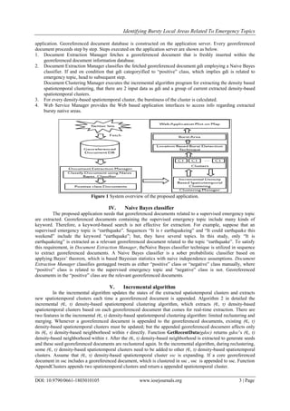
Figure shows an outline of the system for the planned application. Within the system, the application
server has 3 main managers as Document Extraction Manager, Document Clustering Manager, and web Service
Manager. We will observe bursty native areas of emergency topics through a Web application and an Android
Identifying Bursty Local Areas Related To Emergency Topics
DOI: 10.9790/0661-1803010105 www.iosrjournals.org 3 | Page
application. Georeferenced document database is constructed on the application server. Every georeferenced
document proceeds step by step. Steps executed on the application server are shown as below.
1. Document Extraction Manager fetches a georeferenced document that is freshly inserted within the
georeferenced document information database.
2. Document Extraction Manager classifies the fetched georeferenced document gdi employing a Naive Bayes
classifier. If and on condition that gdi categoryified to “positive” class, which implies gdi is related to
emergency topic, head to subsequent step.
Document Clustering Manager executes the incremental algorithm program for extracting the density based
spatiotemporal clustering, that there are 2 input data as gdi and a group of current extracted density-based
spatiotemporal clusters.
3. For every density-based spatiotemporal cluster, the burstiness of the cluster is calculated.
4. Web Service Manager provides the Web based application interfaces to access info regarding extracted
bursty native areas.
Figure 1 System overview of the proposed application.
IV. Naive Bayes classifier
The proposed application needs that georeferenced documents related to a supervised emergency topic
are extracted. Georeferenced documents containing the supervised emergency topic include many kinds of
keyword. Therefore, a keyword-based search is not effective for extraction. For example, suppose that an
supervised emergency topic is “earthquake”. Sequences “It is r earthquakeing” and “It could earthquake this
weekend” include the keyword “earthquake”; but, they have several topics. In this study, only “It is
earthquakeing” is extracted as a relevant georeferenced document related to the topic “earthquake”. To satisfy
this requirement, in Document Extraction Manager, theNaive Bayes classifier technique is utilized in sequence
to extract georeferenced documents. A Naive Bayes classifier is a sober probabilistic classifier based on
applying Bayes’ theorem, which is based Bayesian statistics with naive independence assumptions. Document
Extraction Manager classifies geotagged tweets as either “positive” class or “negative” class manually, where
“positive” class is related to the supervised emergency topic and “negative” class is not. Georeferenced
documents in the “positive” class are the relevant georeferenced documents.
V. Incremental algorithm
In the incremental algorithm updates the states of the extracted spatiotemporal clusters and extracts
new spatiotemporal clusters each time a georeferenced document is appended. Algorithm 2 in detailed the
incremental (∈, τ) density-based spatiotemporal clustering algorithm, which extracts (∈, τ) density-based
spatiotemporal clusters based on each georeferenced document that comes for real-time extraction. There are
two features in the incremental (∈, τ) density-based spatiotemporal clustering algorithm: limited reclustering and
merging. Whenever a georeferenced document is appended to the georeferenced documents, existing (∈, τ)
density-based spatiotemporal clusters must be updated; but the appended georeferenced document affects only
its (∈, τ) density-based neighborhood within τ directly. Function GetRecentData(gdoc) returns gdoc’s (∈, τ)
density-based neighborhood within τ. After the (∈, τ) density-based neighborhood is extracted to generate seeds
and these seed georeferenced documents are reclustered again. In the incremental algorithm, during reclustering,
some (∈, τ) density-based spatiotemporal clusters need to be added to other (∈, τ) density-based spatiotemporal
clusters. Assume that (∈, τ) density-based spatiotemporal cluster ssc is expanding. If a core georeferenced
document in ssc includes a georeferenced document, which is clustered in ssc , ssc is appended to ssc. Function
AppendClusters appends two spatiotemporal clusters and return a appended spatiotemporal cluster.
Identifying Bursty Local Areas Related To Emergency Topics
DOI: 10.9790/0661-1803010105 www.iosrjournals.org 4 | Page
Algorithm
Algorithm 2: Incremental (∈, τ) - density-based spatiotemporal clustering algorithm
Input : gdoc - a newly input georeferenced document, GDOC - a set of georeferenced, CSSC - a set of extracted
spatiotemporal clusters, ∈ - user specified value, τ – user specified value, MGDoc - the minimum number of
georeferenced document
Output: NSSC - a set of updated patiotemporal clusters
NSSC ← CSSC;
RD ←GetRecentData(gdoc, τ ,GDOC);
for i ← 1 to |RD| do
pd ← rdi ∈ RD;
N ←GetNeighborhood(pd, ∈, τ);
if |N| ≥ MGDoc then
if IsClustered(pd) == false then
ssc ←MakeNewCluster(cid, pd);
end if
else
ssc ←GetCluster(pd, NSSC);
end if
EnQueue(Q,N);
while Q is not empty do
gdoc ←DeQueue(Q);
if IsClustered(gdoc) == true then
N ←GetNeighborhood(gdoc, ∈, τ);
if |N| ≥ MGDoc then
ssc ←
GetCluster(gdoc, NSSC);
ssc ←
AppendClusters(ssc, ssc);
end if
end if
else
ssc ← ssc ∪ gdoc;
N ←GetNeighborhood(gdoc, ∈, τ);
if |N| ≥ MGDoc then
EnNniqueQueue(Q,N);
end if
end if
end while
NSSC ← NSSC ∪ ssc;
end if
end for
return NSSC;
VI. Kleinberg’s Burst Detection Algorithm
Kleinberg defined a model with an continue state automaton in which bursts are represented as state
transitions. Suppose that there are m states in the automaton, every interarrival time is a probabilistic output that
depending up on the internal states of the infinite state automaton. In the model, a state is associated with a
burstiness state and a higher state indicates higher burstiness.
Algorithm: Location-Based Burst Detection
input : cutoff distance dist, user position up, word time-series data wi, and parameter list for burst detection
params
output: optimal state-transition sequence S
IAT′CTDi () /* make a empty sequence */
for j 1 to |w−> CTDi| do
if j = 1 then
pctd ← stime
else
pctd ← w−> CTDi[j − 1]
iat ← w−> CTDi[j] − pctd + _(wi−>
Identifying Bursty Local Areas Related To Emergency Topics
DOI: 10.9790/0661-1803010105 www.iosrjournals.org 5 | Page
CTPi[j], up)
IAT′CTDi append_sequence
(IAT′CTDi ,iat)
s KBD (IAT′
CTDi ,params)
return s
VII. Conclusion
So in this paper, we have developed web application and android application to identifying the bursty
local areas related to emergency topics. In additional we are also providing today’s hot topics from tweets are
fetched in our application for the development of our application. We have used naïve bayes classifier
technique, density-based spatiotemporal clustering algorithm and burst detection technique. We mainly focus on
geo tagged tweets and by extracting that tweets we plot the bursty local area on map, for which we have used
streaming API’s of twitter. In future we are planning to develop application in multi language.
VIII. References
[1]. Kaneko T, Yanai K (2013) Visual event mining from geo-tweet photos. In: Multimedia and Expo Workshops (ICMEW) 2013 IEEE
International Conference On. IEEE, San Jose, CA, USA. pp 1–6.
[2]. Tamura K, Kitakami H (2013) Detecting location-based enumerating bursts in georeferenced micro-posts. In: roceedings of the
2013 Second IIAI International Conference on Advanced Applied Informatics. IIAI-AAI ’13. IEEE Computer Society, Los
Alamitos, CA, USA. pp 389–394.
[3]. Tamura K, Ichimura T (2013) Density-based spatiotemporal clustering algorithm for extracting bursty areas from georeferenced
documents. In: Proceedings of The 2013 IEEE International Conference on Systems, Man, and Cybernetics, SMC 2013. IEEE
Computer Society, Los Alamitos, CA, USA. pp 2079–2084.
[4]. Abdelhaq H, Sengstock C, Gertz M (2013) Eventweet: Online localized event detection from twitter. Proc VLDB Endow
6(12):1326–1329.
[5]. Musleh M (2014) Spatio-temporal visual analysis for event-specific tweets. In: Proceedings of the 2014 ACM SIGMOD
International Conference on Management of Data. SIGMOD ’14. ACM, New York, NY, USA. pp 1611–1612.
[6]. Hiruta S, Yonezawa T, Jurmu M, Tokuda H (2012) Detection, classification and visualization of place-triggered geotagged tweets.
In: Proceedings of the 2012 ACM Conference on Ubiquitous Computing UbiComp. ’12. ACM, New York, NY, USA. pp 956–963.
[7]. Hong L, Ahmed A, Gurumurthy S, Smola AJ, Tsioutsiouliklis K (2012) Discovering geographical topics in the twitter stream. In:
Proceedings of the 21st International Conference on World Wide Web. WWW ’12. ACM, New York, NY, USA. pp 769–778.
[8]. Hwang M-H, Wang S, Cao G, Padmanabhan A, Zhang Z (2013) Spatiotemporal transformation of social media geostreams: a case
study of twitter for flu risk analysis. In: Proceedings of the 4th ACM SIGSPATIAL International Workshop on GeoStreaming.
IWGS ’13. ACM, New York, NY, USA. pp 12–21.
[9]. Mandel B, Culotta A, Boulahanis J, Stark D, Lewis B, Rodrigue J (2012) A demographic analysis of online sentiment during
hurricane irene. In: Proceedings of the Second Workshop on Language in Social Media. LSM ’12. Association for Computational
Linguistics, Stroudsburg, PA, USA. pp 27–36

More Related Content

What's hot

BIG DATA SANITIZATION AND CYBER SITUATIONALAWARENESS: A NETWORK TELESCOPE PE...
 BIG DATA SANITIZATION AND CYBER SITUATIONALAWARENESS: A NETWORK TELESCOPE PE... BIG DATA SANITIZATION AND CYBER SITUATIONALAWARENESS: A NETWORK TELESCOPE PE...
BIG DATA SANITIZATION AND CYBER SITUATIONALAWARENESS: A NETWORK TELESCOPE PE...Nexgen Technology
 
Data repository for sensor network a data mining approach
Data repository for sensor network  a data mining approachData repository for sensor network  a data mining approach
Data repository for sensor network a data mining approachijdms
 
Term Paper Presentation
Term Paper PresentationTerm Paper Presentation
Term Paper PresentationShubham Singh
 
Privacy Preserving Multi-keyword Top-K Search based on Cosine Similarity Clus...
Privacy Preserving Multi-keyword Top-K Search based on Cosine Similarity Clus...Privacy Preserving Multi-keyword Top-K Search based on Cosine Similarity Clus...
Privacy Preserving Multi-keyword Top-K Search based on Cosine Similarity Clus...IRJET Journal
 
Monitoring world geopolitics through Big Data by Tomasa Rodrigo and Álvaro Or...
Monitoring world geopolitics through Big Data by Tomasa Rodrigo and Álvaro Or...Monitoring world geopolitics through Big Data by Tomasa Rodrigo and Álvaro Or...
Monitoring world geopolitics through Big Data by Tomasa Rodrigo and Álvaro Or...Big Data Spain
 
Quo vadis, provenancer?  Cui prodest?  our own trajectory: provenance of data...
Quo vadis, provenancer? Cui prodest? our own trajectory: provenance of data...Quo vadis, provenancer? Cui prodest? our own trajectory: provenance of data...
Quo vadis, provenancer?  Cui prodest?  our own trajectory: provenance of data...Paolo Missier
 
Master Thesis Presentation
Master Thesis PresentationMaster Thesis Presentation
Master Thesis PresentationEhab Qadah
 
Data Provenance for Data Science
Data Provenance for Data ScienceData Provenance for Data Science
Data Provenance for Data SciencePaolo Missier
 
A Customisable Pipeline for Continuously Harvesting Socially-Minded Twitter U...
A Customisable Pipeline for Continuously Harvesting Socially-Minded Twitter U...A Customisable Pipeline for Continuously Harvesting Socially-Minded Twitter U...
A Customisable Pipeline for Continuously Harvesting Socially-Minded Twitter U...Paolo Missier
 
Big Data on Implementation of Many to Many Clustering
Big Data on Implementation of Many to Many ClusteringBig Data on Implementation of Many to Many Clustering
Big Data on Implementation of Many to Many Clusteringpaperpublications3
 
Handling Selfishness in Replica Allocation over a Mobile Ad-Hoc Network
Handling Selfishness in Replica Allocation over a Mobile Ad-Hoc NetworkHandling Selfishness in Replica Allocation over a Mobile Ad-Hoc Network
Handling Selfishness in Replica Allocation over a Mobile Ad-Hoc NetworkIJCERT
 
O N T HE D ISTRIBUTION OF T HE M AXIMAL C LIQUE S IZE F OR T HE V ERTICES IN ...
O N T HE D ISTRIBUTION OF T HE M AXIMAL C LIQUE S IZE F OR T HE V ERTICES IN ...O N T HE D ISTRIBUTION OF T HE M AXIMAL C LIQUE S IZE F OR T HE V ERTICES IN ...
O N T HE D ISTRIBUTION OF T HE M AXIMAL C LIQUE S IZE F OR T HE V ERTICES IN ...csandit
 
REDUCING THE COGNITIVE LOAD ON ANALYSTS THROUGH HAMMING DISTANCE BASED ALERT ...
REDUCING THE COGNITIVE LOAD ON ANALYSTS THROUGH HAMMING DISTANCE BASED ALERT ...REDUCING THE COGNITIVE LOAD ON ANALYSTS THROUGH HAMMING DISTANCE BASED ALERT ...
REDUCING THE COGNITIVE LOAD ON ANALYSTS THROUGH HAMMING DISTANCE BASED ALERT ...IJNSA Journal
 
Extracting intelligence from online news sources
Extracting intelligence from online news sourcesExtracting intelligence from online news sources
Extracting intelligence from online news sourceseSAT Publishing House
 
The Impact of Data Replication on Job Scheduling Performance in Hierarchical ...
The Impact of Data Replication on Job Scheduling Performance in Hierarchical ...The Impact of Data Replication on Job Scheduling Performance in Hierarchical ...
The Impact of Data Replication on Job Scheduling Performance in Hierarchical ...graphhoc
 
Client Forensics: An Assessment of Existing Research And Future Directions
Client Forensics: An Assessment of Existing Research And Future DirectionsClient Forensics: An Assessment of Existing Research And Future Directions
Client Forensics: An Assessment of Existing Research And Future DirectionsCSCJournals
 

What's hot (17)

BIG DATA SANITIZATION AND CYBER SITUATIONALAWARENESS: A NETWORK TELESCOPE PE...
 BIG DATA SANITIZATION AND CYBER SITUATIONALAWARENESS: A NETWORK TELESCOPE PE... BIG DATA SANITIZATION AND CYBER SITUATIONALAWARENESS: A NETWORK TELESCOPE PE...
BIG DATA SANITIZATION AND CYBER SITUATIONALAWARENESS: A NETWORK TELESCOPE PE...
 
Data repository for sensor network a data mining approach
Data repository for sensor network  a data mining approachData repository for sensor network  a data mining approach
Data repository for sensor network a data mining approach
 
Term Paper Presentation
Term Paper PresentationTerm Paper Presentation
Term Paper Presentation
 
Privacy Preserving Multi-keyword Top-K Search based on Cosine Similarity Clus...
Privacy Preserving Multi-keyword Top-K Search based on Cosine Similarity Clus...Privacy Preserving Multi-keyword Top-K Search based on Cosine Similarity Clus...
Privacy Preserving Multi-keyword Top-K Search based on Cosine Similarity Clus...
 
Big data analytics
Big data analyticsBig data analytics
Big data analytics
 
Monitoring world geopolitics through Big Data by Tomasa Rodrigo and Álvaro Or...
Monitoring world geopolitics through Big Data by Tomasa Rodrigo and Álvaro Or...Monitoring world geopolitics through Big Data by Tomasa Rodrigo and Álvaro Or...
Monitoring world geopolitics through Big Data by Tomasa Rodrigo and Álvaro Or...
 
Quo vadis, provenancer?  Cui prodest?  our own trajectory: provenance of data...
Quo vadis, provenancer? Cui prodest? our own trajectory: provenance of data...Quo vadis, provenancer? Cui prodest? our own trajectory: provenance of data...
Quo vadis, provenancer?  Cui prodest?  our own trajectory: provenance of data...
 
Master Thesis Presentation
Master Thesis PresentationMaster Thesis Presentation
Master Thesis Presentation
 
Data Provenance for Data Science
Data Provenance for Data ScienceData Provenance for Data Science
Data Provenance for Data Science
 
A Customisable Pipeline for Continuously Harvesting Socially-Minded Twitter U...
A Customisable Pipeline for Continuously Harvesting Socially-Minded Twitter U...A Customisable Pipeline for Continuously Harvesting Socially-Minded Twitter U...
A Customisable Pipeline for Continuously Harvesting Socially-Minded Twitter U...
 
Big Data on Implementation of Many to Many Clustering
Big Data on Implementation of Many to Many ClusteringBig Data on Implementation of Many to Many Clustering
Big Data on Implementation of Many to Many Clustering
 
Handling Selfishness in Replica Allocation over a Mobile Ad-Hoc Network
Handling Selfishness in Replica Allocation over a Mobile Ad-Hoc NetworkHandling Selfishness in Replica Allocation over a Mobile Ad-Hoc Network
Handling Selfishness in Replica Allocation over a Mobile Ad-Hoc Network
 
O N T HE D ISTRIBUTION OF T HE M AXIMAL C LIQUE S IZE F OR T HE V ERTICES IN ...
O N T HE D ISTRIBUTION OF T HE M AXIMAL C LIQUE S IZE F OR T HE V ERTICES IN ...O N T HE D ISTRIBUTION OF T HE M AXIMAL C LIQUE S IZE F OR T HE V ERTICES IN ...
O N T HE D ISTRIBUTION OF T HE M AXIMAL C LIQUE S IZE F OR T HE V ERTICES IN ...
 
REDUCING THE COGNITIVE LOAD ON ANALYSTS THROUGH HAMMING DISTANCE BASED ALERT ...
REDUCING THE COGNITIVE LOAD ON ANALYSTS THROUGH HAMMING DISTANCE BASED ALERT ...REDUCING THE COGNITIVE LOAD ON ANALYSTS THROUGH HAMMING DISTANCE BASED ALERT ...
REDUCING THE COGNITIVE LOAD ON ANALYSTS THROUGH HAMMING DISTANCE BASED ALERT ...
 
Extracting intelligence from online news sources
Extracting intelligence from online news sourcesExtracting intelligence from online news sources
Extracting intelligence from online news sources
 
The Impact of Data Replication on Job Scheduling Performance in Hierarchical ...
The Impact of Data Replication on Job Scheduling Performance in Hierarchical ...The Impact of Data Replication on Job Scheduling Performance in Hierarchical ...
The Impact of Data Replication on Job Scheduling Performance in Hierarchical ...
 
Client Forensics: An Assessment of Existing Research And Future Directions
Client Forensics: An Assessment of Existing Research And Future DirectionsClient Forensics: An Assessment of Existing Research And Future Directions
Client Forensics: An Assessment of Existing Research And Future Directions
 

Viewers also liked

Perception of Economic and Environmental Impact of Christmas Festival/Calabar...
Perception of Economic and Environmental Impact of Christmas Festival/Calabar...Perception of Economic and Environmental Impact of Christmas Festival/Calabar...
Perception of Economic and Environmental Impact of Christmas Festival/Calabar...IOSR Journals
 
Flower Classification Using Neural Network Based Image Processing
Flower Classification Using Neural Network Based Image ProcessingFlower Classification Using Neural Network Based Image Processing
Flower Classification Using Neural Network Based Image ProcessingIOSR Journals
 
Peak to Average Power Ratio Reduction in Mc Cdma System by Using Pulse Shapin...
Peak to Average Power Ratio Reduction in Mc Cdma System by Using Pulse Shapin...Peak to Average Power Ratio Reduction in Mc Cdma System by Using Pulse Shapin...
Peak to Average Power Ratio Reduction in Mc Cdma System by Using Pulse Shapin...IOSR Journals
 
Performance Evaluation of Basic Segmented Algorithms for Brain Tumor Detection
Performance Evaluation of Basic Segmented Algorithms for Brain Tumor DetectionPerformance Evaluation of Basic Segmented Algorithms for Brain Tumor Detection
Performance Evaluation of Basic Segmented Algorithms for Brain Tumor DetectionIOSR Journals
 
Effects of EM Radiation on Living System
Effects of EM Radiation on Living System Effects of EM Radiation on Living System
Effects of EM Radiation on Living System IOSR Journals
 

Viewers also liked (20)

Perception of Economic and Environmental Impact of Christmas Festival/Calabar...
Perception of Economic and Environmental Impact of Christmas Festival/Calabar...Perception of Economic and Environmental Impact of Christmas Festival/Calabar...
Perception of Economic and Environmental Impact of Christmas Festival/Calabar...
 
E012223438
E012223438E012223438
E012223438
 
E0812730
E0812730E0812730
E0812730
 
Flower Classification Using Neural Network Based Image Processing
Flower Classification Using Neural Network Based Image ProcessingFlower Classification Using Neural Network Based Image Processing
Flower Classification Using Neural Network Based Image Processing
 
Peak to Average Power Ratio Reduction in Mc Cdma System by Using Pulse Shapin...
Peak to Average Power Ratio Reduction in Mc Cdma System by Using Pulse Shapin...Peak to Average Power Ratio Reduction in Mc Cdma System by Using Pulse Shapin...
Peak to Average Power Ratio Reduction in Mc Cdma System by Using Pulse Shapin...
 
C010211319
C010211319C010211319
C010211319
 
Performance Evaluation of Basic Segmented Algorithms for Brain Tumor Detection
Performance Evaluation of Basic Segmented Algorithms for Brain Tumor DetectionPerformance Evaluation of Basic Segmented Algorithms for Brain Tumor Detection
Performance Evaluation of Basic Segmented Algorithms for Brain Tumor Detection
 
F1304013139
F1304013139F1304013139
F1304013139
 
F010624050
F010624050F010624050
F010624050
 
L013167279
L013167279L013167279
L013167279
 
G012614354
G012614354G012614354
G012614354
 
F017513138
F017513138F017513138
F017513138
 
N010438890
N010438890N010438890
N010438890
 
A018120105
A018120105A018120105
A018120105
 
D012473845
D012473845D012473845
D012473845
 
E017373946
E017373946E017373946
E017373946
 
E010522527
E010522527E010522527
E010522527
 
Effects of EM Radiation on Living System
Effects of EM Radiation on Living System Effects of EM Radiation on Living System
Effects of EM Radiation on Living System
 
A010420106
A010420106A010420106
A010420106
 
D017412935
D017412935D017412935
D017412935
 

Similar to A1803010105

IJCER (www.ijceronline.com) International Journal of computational Engineerin...
IJCER (www.ijceronline.com) International Journal of computational Engineerin...IJCER (www.ijceronline.com) International Journal of computational Engineerin...
IJCER (www.ijceronline.com) International Journal of computational Engineerin...ijceronline
 
Novel holistic architecture for analytical operation on sensory data relayed...
Novel holistic architecture for analytical operation  on sensory data relayed...Novel holistic architecture for analytical operation  on sensory data relayed...
Novel holistic architecture for analytical operation on sensory data relayed...IJECEIAES
 
IEEE SIGHT Bombay section webinar talk on GIS & Remote Sensing-Introduction t...
IEEE SIGHT Bombay section webinar talk on GIS & Remote Sensing-Introduction t...IEEE SIGHT Bombay section webinar talk on GIS & Remote Sensing-Introduction t...
IEEE SIGHT Bombay section webinar talk on GIS & Remote Sensing-Introduction t...AdityaAllamraju1
 
Event detection and summarization based on social networks and semantic query...
Event detection and summarization based on social networks and semantic query...Event detection and summarization based on social networks and semantic query...
Event detection and summarization based on social networks and semantic query...ijnlc
 
An Efficient Approach for Clustering High Dimensional Data
An Efficient Approach for Clustering High Dimensional DataAn Efficient Approach for Clustering High Dimensional Data
An Efficient Approach for Clustering High Dimensional DataIJSTA
 
Meliorating usable document density for online event detection
Meliorating usable document density for online event detectionMeliorating usable document density for online event detection
Meliorating usable document density for online event detectionIJICTJOURNAL
 
A time efficient approach for detecting errors in big sensor data on cloud
A time efficient approach for detecting errors in big sensor data on cloudA time efficient approach for detecting errors in big sensor data on cloud
A time efficient approach for detecting errors in big sensor data on cloudNexgen Technology
 
Concept Drift Identification using Classifier Ensemble Approach
Concept Drift Identification using Classifier Ensemble Approach  Concept Drift Identification using Classifier Ensemble Approach
Concept Drift Identification using Classifier Ensemble Approach IJECEIAES
 
Novel Methodology of Data Management in Ad Hoc Network Formulated using Nanos...
Novel Methodology of Data Management in Ad Hoc Network Formulated using Nanos...Novel Methodology of Data Management in Ad Hoc Network Formulated using Nanos...
Novel Methodology of Data Management in Ad Hoc Network Formulated using Nanos...Drjabez
 
Drsp dimension reduction for similarity matching and pruning of time series ...
Drsp  dimension reduction for similarity matching and pruning of time series ...Drsp  dimension reduction for similarity matching and pruning of time series ...
Drsp dimension reduction for similarity matching and pruning of time series ...IJDKP
 
Analysis of Crime Big Data using MapReduce
Analysis of Crime Big Data using MapReduceAnalysis of Crime Big Data using MapReduce
Analysis of Crime Big Data using MapReduceKaushik Rajan
 
A study of existing ontologies in the io t domain
A study of existing ontologies in the io t domainA study of existing ontologies in the io t domain
A study of existing ontologies in the io t domainSof Ouni
 
Certain Analysis on Traffic Dataset based on Data Mining Algorithms
Certain Analysis on Traffic Dataset based on Data Mining AlgorithmsCertain Analysis on Traffic Dataset based on Data Mining Algorithms
Certain Analysis on Traffic Dataset based on Data Mining AlgorithmsIRJET Journal
 
Data dissemination and materials informatics at LBNL
Data dissemination and materials informatics at LBNLData dissemination and materials informatics at LBNL
Data dissemination and materials informatics at LBNLAnubhav Jain
 

Similar to A1803010105 (20)

IJCER (www.ijceronline.com) International Journal of computational Engineerin...
IJCER (www.ijceronline.com) International Journal of computational Engineerin...IJCER (www.ijceronline.com) International Journal of computational Engineerin...
IJCER (www.ijceronline.com) International Journal of computational Engineerin...
 
Novel holistic architecture for analytical operation on sensory data relayed...
Novel holistic architecture for analytical operation  on sensory data relayed...Novel holistic architecture for analytical operation  on sensory data relayed...
Novel holistic architecture for analytical operation on sensory data relayed...
 
Ijariie1184
Ijariie1184Ijariie1184
Ijariie1184
 
Ijariie1184
Ijariie1184Ijariie1184
Ijariie1184
 
IEEE SIGHT Bombay section webinar talk on GIS & Remote Sensing-Introduction t...
IEEE SIGHT Bombay section webinar talk on GIS & Remote Sensing-Introduction t...IEEE SIGHT Bombay section webinar talk on GIS & Remote Sensing-Introduction t...
IEEE SIGHT Bombay section webinar talk on GIS & Remote Sensing-Introduction t...
 
Event detection and summarization based on social networks and semantic query...
Event detection and summarization based on social networks and semantic query...Event detection and summarization based on social networks and semantic query...
Event detection and summarization based on social networks and semantic query...
 
An Efficient Approach for Clustering High Dimensional Data
An Efficient Approach for Clustering High Dimensional DataAn Efficient Approach for Clustering High Dimensional Data
An Efficient Approach for Clustering High Dimensional Data
 
Meliorating usable document density for online event detection
Meliorating usable document density for online event detectionMeliorating usable document density for online event detection
Meliorating usable document density for online event detection
 
A time efficient approach for detecting errors in big sensor data on cloud
A time efficient approach for detecting errors in big sensor data on cloudA time efficient approach for detecting errors in big sensor data on cloud
A time efficient approach for detecting errors in big sensor data on cloud
 
IJET-V3I1P3
IJET-V3I1P3IJET-V3I1P3
IJET-V3I1P3
 
Big Data and IOT
Big Data and IOTBig Data and IOT
Big Data and IOT
 
Concept Drift Identification using Classifier Ensemble Approach
Concept Drift Identification using Classifier Ensemble Approach  Concept Drift Identification using Classifier Ensemble Approach
Concept Drift Identification using Classifier Ensemble Approach
 
Novel Methodology of Data Management in Ad Hoc Network Formulated using Nanos...
Novel Methodology of Data Management in Ad Hoc Network Formulated using Nanos...Novel Methodology of Data Management in Ad Hoc Network Formulated using Nanos...
Novel Methodology of Data Management in Ad Hoc Network Formulated using Nanos...
 
Drsp dimension reduction for similarity matching and pruning of time series ...
Drsp  dimension reduction for similarity matching and pruning of time series ...Drsp  dimension reduction for similarity matching and pruning of time series ...
Drsp dimension reduction for similarity matching and pruning of time series ...
 
Analysis of Crime Big Data using MapReduce
Analysis of Crime Big Data using MapReduceAnalysis of Crime Big Data using MapReduce
Analysis of Crime Big Data using MapReduce
 
A study of existing ontologies in the io t domain
A study of existing ontologies in the io t domainA study of existing ontologies in the io t domain
A study of existing ontologies in the io t domain
 
CS846_report_akshat_kumar
CS846_report_akshat_kumarCS846_report_akshat_kumar
CS846_report_akshat_kumar
 
Certain Analysis on Traffic Dataset based on Data Mining Algorithms
Certain Analysis on Traffic Dataset based on Data Mining AlgorithmsCertain Analysis on Traffic Dataset based on Data Mining Algorithms
Certain Analysis on Traffic Dataset based on Data Mining Algorithms
 
G1803054653
G1803054653G1803054653
G1803054653
 
Data dissemination and materials informatics at LBNL
Data dissemination and materials informatics at LBNLData dissemination and materials informatics at LBNL
Data dissemination and materials informatics at LBNL
 

More from IOSR Journals (20)

A011140104
A011140104A011140104
A011140104
 
M0111397100
M0111397100M0111397100
M0111397100
 
L011138596
L011138596L011138596
L011138596
 
K011138084
K011138084K011138084
K011138084
 
J011137479
J011137479J011137479
J011137479
 
I011136673
I011136673I011136673
I011136673
 
G011134454
G011134454G011134454
G011134454
 
H011135565
H011135565H011135565
H011135565
 
F011134043
F011134043F011134043
F011134043
 
E011133639
E011133639E011133639
E011133639
 
D011132635
D011132635D011132635
D011132635
 
C011131925
C011131925C011131925
C011131925
 
B011130918
B011130918B011130918
B011130918
 
A011130108
A011130108A011130108
A011130108
 
I011125160
I011125160I011125160
I011125160
 
H011124050
H011124050H011124050
H011124050
 
G011123539
G011123539G011123539
G011123539
 
F011123134
F011123134F011123134
F011123134
 
E011122530
E011122530E011122530
E011122530
 
D011121524
D011121524D011121524
D011121524
 

Recently uploaded

Kotlin Multiplatform & Compose Multiplatform - Starter kit for pragmatics
Kotlin Multiplatform & Compose Multiplatform - Starter kit for pragmaticsKotlin Multiplatform & Compose Multiplatform - Starter kit for pragmatics
Kotlin Multiplatform & Compose Multiplatform - Starter kit for pragmaticscarlostorres15106
 
GenCyber Cyber Security Day Presentation
GenCyber Cyber Security Day PresentationGenCyber Cyber Security Day Presentation
GenCyber Cyber Security Day PresentationMichael W. Hawkins
 
Enhancing Worker Digital Experience: A Hands-on Workshop for Partners
Enhancing Worker Digital Experience: A Hands-on Workshop for PartnersEnhancing Worker Digital Experience: A Hands-on Workshop for Partners
Enhancing Worker Digital Experience: A Hands-on Workshop for PartnersThousandEyes
 
Presentation on how to chat with PDF using ChatGPT code interpreter
Presentation on how to chat with PDF using ChatGPT code interpreterPresentation on how to chat with PDF using ChatGPT code interpreter
Presentation on how to chat with PDF using ChatGPT code interpreternaman860154
 
Tech-Forward - Achieving Business Readiness For Copilot in Microsoft 365
Tech-Forward - Achieving Business Readiness For Copilot in Microsoft 365Tech-Forward - Achieving Business Readiness For Copilot in Microsoft 365
Tech-Forward - Achieving Business Readiness For Copilot in Microsoft 3652toLead Limited
 
08448380779 Call Girls In Diplomatic Enclave Women Seeking Men
08448380779 Call Girls In Diplomatic Enclave Women Seeking Men08448380779 Call Girls In Diplomatic Enclave Women Seeking Men
08448380779 Call Girls In Diplomatic Enclave Women Seeking MenDelhi Call girls
 
WhatsApp 9892124323 ✓Call Girls In Kalyan ( Mumbai ) secure service
WhatsApp 9892124323 ✓Call Girls In Kalyan ( Mumbai ) secure serviceWhatsApp 9892124323 ✓Call Girls In Kalyan ( Mumbai ) secure service
WhatsApp 9892124323 ✓Call Girls In Kalyan ( Mumbai ) secure servicePooja Nehwal
 
FULL ENJOY 🔝 8264348440 🔝 Call Girls in Diplomatic Enclave | Delhi
FULL ENJOY 🔝 8264348440 🔝 Call Girls in Diplomatic Enclave | DelhiFULL ENJOY 🔝 8264348440 🔝 Call Girls in Diplomatic Enclave | Delhi
FULL ENJOY 🔝 8264348440 🔝 Call Girls in Diplomatic Enclave | Delhisoniya singh
 
Making_way_through_DLL_hollowing_inspite_of_CFG_by_Debjeet Banerjee.pptx
Making_way_through_DLL_hollowing_inspite_of_CFG_by_Debjeet Banerjee.pptxMaking_way_through_DLL_hollowing_inspite_of_CFG_by_Debjeet Banerjee.pptx
Making_way_through_DLL_hollowing_inspite_of_CFG_by_Debjeet Banerjee.pptxnull - The Open Security Community
 
SIEMENS: RAPUNZEL – A Tale About Knowledge Graph
SIEMENS: RAPUNZEL – A Tale About Knowledge GraphSIEMENS: RAPUNZEL – A Tale About Knowledge Graph
SIEMENS: RAPUNZEL – A Tale About Knowledge GraphNeo4j
 
SQL Database Design For Developers at php[tek] 2024
SQL Database Design For Developers at php[tek] 2024SQL Database Design For Developers at php[tek] 2024
SQL Database Design For Developers at php[tek] 2024Scott Keck-Warren
 
Transforming Data Streams with Kafka Connect: An Introduction to Single Messa...
Transforming Data Streams with Kafka Connect: An Introduction to Single Messa...Transforming Data Streams with Kafka Connect: An Introduction to Single Messa...
Transforming Data Streams with Kafka Connect: An Introduction to Single Messa...HostedbyConfluent
 
Injustice - Developers Among Us (SciFiDevCon 2024)
Injustice - Developers Among Us (SciFiDevCon 2024)Injustice - Developers Among Us (SciFiDevCon 2024)
Injustice - Developers Among Us (SciFiDevCon 2024)Allon Mureinik
 
Integration and Automation in Practice: CI/CD in Mule Integration and Automat...
Integration and Automation in Practice: CI/CD in Mule Integration and Automat...Integration and Automation in Practice: CI/CD in Mule Integration and Automat...
Integration and Automation in Practice: CI/CD in Mule Integration and Automat...Patryk Bandurski
 
How to convert PDF to text with Nanonets
How to convert PDF to text with NanonetsHow to convert PDF to text with Nanonets
How to convert PDF to text with Nanonetsnaman860154
 
Automating Business Process via MuleSoft Composer | Bangalore MuleSoft Meetup...
Automating Business Process via MuleSoft Composer | Bangalore MuleSoft Meetup...Automating Business Process via MuleSoft Composer | Bangalore MuleSoft Meetup...
Automating Business Process via MuleSoft Composer | Bangalore MuleSoft Meetup...shyamraj55
 
Unblocking The Main Thread Solving ANRs and Frozen Frames
Unblocking The Main Thread Solving ANRs and Frozen FramesUnblocking The Main Thread Solving ANRs and Frozen Frames
Unblocking The Main Thread Solving ANRs and Frozen FramesSinan KOZAK
 
How to Remove Document Management Hurdles with X-Docs?
How to Remove Document Management Hurdles with X-Docs?How to Remove Document Management Hurdles with X-Docs?
How to Remove Document Management Hurdles with X-Docs?XfilesPro
 
Swan(sea) Song – personal research during my six years at Swansea ... and bey...
Swan(sea) Song – personal research during my six years at Swansea ... and bey...Swan(sea) Song – personal research during my six years at Swansea ... and bey...
Swan(sea) Song – personal research during my six years at Swansea ... and bey...Alan Dix
 

Recently uploaded (20)

Kotlin Multiplatform & Compose Multiplatform - Starter kit for pragmatics
Kotlin Multiplatform & Compose Multiplatform - Starter kit for pragmaticsKotlin Multiplatform & Compose Multiplatform - Starter kit for pragmatics
Kotlin Multiplatform & Compose Multiplatform - Starter kit for pragmatics
 
GenCyber Cyber Security Day Presentation
GenCyber Cyber Security Day PresentationGenCyber Cyber Security Day Presentation
GenCyber Cyber Security Day Presentation
 
Enhancing Worker Digital Experience: A Hands-on Workshop for Partners
Enhancing Worker Digital Experience: A Hands-on Workshop for PartnersEnhancing Worker Digital Experience: A Hands-on Workshop for Partners
Enhancing Worker Digital Experience: A Hands-on Workshop for Partners
 
Presentation on how to chat with PDF using ChatGPT code interpreter
Presentation on how to chat with PDF using ChatGPT code interpreterPresentation on how to chat with PDF using ChatGPT code interpreter
Presentation on how to chat with PDF using ChatGPT code interpreter
 
Tech-Forward - Achieving Business Readiness For Copilot in Microsoft 365
Tech-Forward - Achieving Business Readiness For Copilot in Microsoft 365Tech-Forward - Achieving Business Readiness For Copilot in Microsoft 365
Tech-Forward - Achieving Business Readiness For Copilot in Microsoft 365
 
08448380779 Call Girls In Diplomatic Enclave Women Seeking Men
08448380779 Call Girls In Diplomatic Enclave Women Seeking Men08448380779 Call Girls In Diplomatic Enclave Women Seeking Men
08448380779 Call Girls In Diplomatic Enclave Women Seeking Men
 
WhatsApp 9892124323 ✓Call Girls In Kalyan ( Mumbai ) secure service
WhatsApp 9892124323 ✓Call Girls In Kalyan ( Mumbai ) secure serviceWhatsApp 9892124323 ✓Call Girls In Kalyan ( Mumbai ) secure service
WhatsApp 9892124323 ✓Call Girls In Kalyan ( Mumbai ) secure service
 
FULL ENJOY 🔝 8264348440 🔝 Call Girls in Diplomatic Enclave | Delhi
FULL ENJOY 🔝 8264348440 🔝 Call Girls in Diplomatic Enclave | DelhiFULL ENJOY 🔝 8264348440 🔝 Call Girls in Diplomatic Enclave | Delhi
FULL ENJOY 🔝 8264348440 🔝 Call Girls in Diplomatic Enclave | Delhi
 
Making_way_through_DLL_hollowing_inspite_of_CFG_by_Debjeet Banerjee.pptx
Making_way_through_DLL_hollowing_inspite_of_CFG_by_Debjeet Banerjee.pptxMaking_way_through_DLL_hollowing_inspite_of_CFG_by_Debjeet Banerjee.pptx
Making_way_through_DLL_hollowing_inspite_of_CFG_by_Debjeet Banerjee.pptx
 
SIEMENS: RAPUNZEL – A Tale About Knowledge Graph
SIEMENS: RAPUNZEL – A Tale About Knowledge GraphSIEMENS: RAPUNZEL – A Tale About Knowledge Graph
SIEMENS: RAPUNZEL – A Tale About Knowledge Graph
 
SQL Database Design For Developers at php[tek] 2024
SQL Database Design For Developers at php[tek] 2024SQL Database Design For Developers at php[tek] 2024
SQL Database Design For Developers at php[tek] 2024
 
Transforming Data Streams with Kafka Connect: An Introduction to Single Messa...
Transforming Data Streams with Kafka Connect: An Introduction to Single Messa...Transforming Data Streams with Kafka Connect: An Introduction to Single Messa...
Transforming Data Streams with Kafka Connect: An Introduction to Single Messa...
 
Injustice - Developers Among Us (SciFiDevCon 2024)
Injustice - Developers Among Us (SciFiDevCon 2024)Injustice - Developers Among Us (SciFiDevCon 2024)
Injustice - Developers Among Us (SciFiDevCon 2024)
 
Integration and Automation in Practice: CI/CD in Mule Integration and Automat...
Integration and Automation in Practice: CI/CD in Mule Integration and Automat...Integration and Automation in Practice: CI/CD in Mule Integration and Automat...
Integration and Automation in Practice: CI/CD in Mule Integration and Automat...
 
How to convert PDF to text with Nanonets
How to convert PDF to text with NanonetsHow to convert PDF to text with Nanonets
How to convert PDF to text with Nanonets
 
Automating Business Process via MuleSoft Composer | Bangalore MuleSoft Meetup...
Automating Business Process via MuleSoft Composer | Bangalore MuleSoft Meetup...Automating Business Process via MuleSoft Composer | Bangalore MuleSoft Meetup...
Automating Business Process via MuleSoft Composer | Bangalore MuleSoft Meetup...
 
Unblocking The Main Thread Solving ANRs and Frozen Frames
Unblocking The Main Thread Solving ANRs and Frozen FramesUnblocking The Main Thread Solving ANRs and Frozen Frames
Unblocking The Main Thread Solving ANRs and Frozen Frames
 
Vulnerability_Management_GRC_by Sohang Sengupta.pptx
Vulnerability_Management_GRC_by Sohang Sengupta.pptxVulnerability_Management_GRC_by Sohang Sengupta.pptx
Vulnerability_Management_GRC_by Sohang Sengupta.pptx
 
How to Remove Document Management Hurdles with X-Docs?
How to Remove Document Management Hurdles with X-Docs?How to Remove Document Management Hurdles with X-Docs?
How to Remove Document Management Hurdles with X-Docs?
 
Swan(sea) Song – personal research during my six years at Swansea ... and bey...
Swan(sea) Song – personal research during my six years at Swansea ... and bey...Swan(sea) Song – personal research during my six years at Swansea ... and bey...
Swan(sea) Song – personal research during my six years at Swansea ... and bey...
 

A1803010105

  • 1. IOSR Journal of Computer Engineering (IOSR-JCE) e-ISSN: 2278-0661,p-ISSN: 2278-8727, Volume 18, Issue 3, Ver. I (May-Jun.2016), PP 01-05 www.iosrjournals.org DOI: 10.9790/0661-1803010105 www.iosrjournals.org 1 | Page Identifying Bursty Local Areas Related To Emergency Topics S. S. More1 , Deepak Walkar2 , Parikshit Pishte3 , Saurabh Patil4 , Ritesh Kedari5 , Dhananjay Prabhawalkar6 S. S. More, Professor, Dept. Computer Science and Engineering, Sanjay Ghodawat Institute, Deepak Walkar, Parikshit Pishte, Saurabh Patil, Ritesh Kedari, Dhananjay Prabhawalkar, BE Scholars, Sanjay Ghodawat Institute, Atigre. Abstract: As the social media has gained more attention from users on the Internet, social media has been one of the most important information sources in the world. And, with the increasing popularity of social media, data which is posted on social media sites are rapidly becoming popular, which is a term used to refer to new media that is replacing traditional media. In this paper, we concentrate on geotagged tweets on the Twitter site. These geotagged tweets are known to as georeferenced documents because they include not only a short text message, but also have documents’ which are posting time and location. Many researchers have been handling the development of new data mining techniques for georeferenced documents to recognize and analyze emergency topics, such as natural disasters, weather, diseases, and other incidents. In particular, the utilization of geotagged tweets to recognize and analyze natural disasters has received much attention from administrative agencies recently because some case studies have achieved compelling results. In this paper, we propose a novel real-time analysis application for identifying bursty local areas related to emergency topics. The aim of our application is to provide new platforms that can identify and analyze the localities of emergency topics. The proposed application is of three core computational intelligence techniques: the Naive Bayes classifier technique, the spatiotemporal clustering technique, and the burst detection technique. Also, we have implemented two types of application: a Web application interface and an android application. To evaluate the proposed application, we have implemented a real-time weather observation system embedded the proposed application. We used actual crawling geotagged tweets posted on the Twitter site. The weather detection system successfully detected bursty local areas related to observe emergency weather topics. Keywords : Spatiotemporal clustering, Density-based clustering, Social media, Naive Bayes, Burst detection. I. Introduction From recent years, social media has played a significant role as an another source of information. Now a days, people actively send and receive information about emergency topics, such as diseases, natural disasters, weather, and other incidents. Improvement of the utilization of social media for emergency topics management is one of the most important issues being debated in public and governmental institutions. Therefore, a large number of researchers have focused on the improvement of emergency topic and event detection through social media. This direction provides an opportunity for addressing new challenges in so many different application domains: how to detect where emergency occur and what they are going on. In this case, we mainly consternate on geotagged tweets posted on the Twitter site. These geotagged tweets are assumed to as georeferenced documents because they usually include not only a short text message, but also the documents’ posting time and location. People on the Twitter site are referred to as a social sensors and geotagged tweets as a sensor data supervised by the social sensors. It is of value to people interested in a several topic to supervise dense areas where many georeferenced documents related to the topic are located. In this paper, these dense areas are referred to as bursty local areas related to the topic. In this paper, we propose a novel real-time analysis application for identifying bursty local areas related to emergency topics. The aim of our new application is to provide new platforms that can searching and analyze the localities of emergency topics. The proposed application is composed of three main computational intelligence techniques: the Naive Bayes classifier technique, the spatiotemporal clustering technique, and the burst detection technique. The density-based spatiotemporal clustering algorithm is a useful algorithm for extracting bursty local areas; however, two functional problems remain unresolved. One problem is that the density-based spatiotemporal clustering algorithm does not support real-time extraction. The second problem is that the proposed algorithm is based on keywords. Therefore, relevant georeferenced documents are extracted if they include an supervise keyword, not an observed topic; and this causes error extraction.
  • 2. Identifying Bursty Local Areas Related To Emergency Topics DOI: 10.9790/0661-1803010105 www.iosrjournals.org 2 | Page II. Density-Based Spatiotemporal Clustering The density-based spatiotemporal clustering algorithm is based on the density-based spatial clustering algorithm Sander. In the density-based spatial clustering algorithm, spatial clusters are dense level areas that are divided from areas of low level density. In other words, areas with high level densities of data points can be supposed spatial clusters, whereas those with low level density can’t. The main concept under the use of the density based spatial clustering algorithm shows that, for each data point within a spatial cluster, the neighborhood of a user-defined radius must contain at least a low number of points; that is, the density in the neighborhood must greater than some predefined threshold. Algorithm that has impacted the density-based spatial clustering algorithm is the DBSCAN algorithm, which was firstly presented by Ester et al. (1996). DBSCAN utilizes neighborhood density and identifies areas in which densities are greater than in other areas. However, it does not assume limited time changes. The density-based spatiotemporal clustering algorithm drawn out density-based spatiotemporal clusters that are both limited time and spatially-separated from other spatial clusters. Algorithm: Algorithm 1 in detailed the batch algorithm for density-based spatiotemporal clustering. In algorithm 1, for each georeferenced document gdp in GDOC, the function IsClustered checks whether document gdp is already assigned to a spatiotemporal cluster. Then, the density-based neighborhood of document gdp is obtained using the function GetNeighborhood. If georeferenced document gdp is a main document according to Definition, it is assigned to a new spatiotemporal cluster, and all the neighbors are queued to Q for further processing. The processing and assignment of georeferenced documents to the current spatiotemporal cluster continues until the queue is empty. The next georeferenced document is dequeued from queue Q. If the dequeued georeferenced document is not already assigned to the current spatiotemporal cluster, it is assigned to the current spatiotemporal cluster. Then, if the dequeued document is a core document, the georeferenced documents in the (ϵ, τ)-density-based neighborhood of the dequeued georeferenced document are queued in queue Q using the function EnNniqueQ, which places the input georeferenced documents into queue Q if they are not already existing in queue Q. Algorithm 1: (ϵ,τ)-density-based spatiotemporal clustering algorithm input: GDOC - a set of georeferenced document, ϵ - neighborhood radius, τ - interarrival time, MGDoc is threshold value output: SSC - set of spatiotemporal clusters ctid ← 1; SSC ← φ; for i ← 1 to |GDOC| do pd ← gdi ∈ GDOC; if IsClustered(gdp) == false then N ←GetNeighborhood(gdp, ϵ, τ); if |N| ≥ MGDoc then sscctid ←NewCluster(ctid, gdp); ctid ← ctid + 1; EnQ(Q,N); while Q is not empty do pq ←DeQ(Q); sscctid ← sscctid ∪ pq; N ←GetNeighborhood(gdq, ϵ, τ); if |N| ≥ MGDoc then EnUniqueQ(Q,N); end if end while SSC ← SSC ∪ sscctid; end if end if end for return SSC; III. System overview Figure shows an outline of the system for the planned application. Within the system, the application server has 3 main managers as Document Extraction Manager, Document Clustering Manager, and web Service Manager. We will observe bursty native areas of emergency topics through a Web application and an Android
  • 3. Identifying Bursty Local Areas Related To Emergency Topics DOI: 10.9790/0661-1803010105 www.iosrjournals.org 3 | Page application. Georeferenced document database is constructed on the application server. Every georeferenced document proceeds step by step. Steps executed on the application server are shown as below. 1. Document Extraction Manager fetches a georeferenced document that is freshly inserted within the georeferenced document information database. 2. Document Extraction Manager classifies the fetched georeferenced document gdi employing a Naive Bayes classifier. If and on condition that gdi categoryified to “positive” class, which implies gdi is related to emergency topic, head to subsequent step. Document Clustering Manager executes the incremental algorithm program for extracting the density based spatiotemporal clustering, that there are 2 input data as gdi and a group of current extracted density-based spatiotemporal clusters. 3. For every density-based spatiotemporal cluster, the burstiness of the cluster is calculated. 4. Web Service Manager provides the Web based application interfaces to access info regarding extracted bursty native areas. Figure 1 System overview of the proposed application. IV. Naive Bayes classifier The proposed application needs that georeferenced documents related to a supervised emergency topic are extracted. Georeferenced documents containing the supervised emergency topic include many kinds of keyword. Therefore, a keyword-based search is not effective for extraction. For example, suppose that an supervised emergency topic is “earthquake”. Sequences “It is r earthquakeing” and “It could earthquake this weekend” include the keyword “earthquake”; but, they have several topics. In this study, only “It is earthquakeing” is extracted as a relevant georeferenced document related to the topic “earthquake”. To satisfy this requirement, in Document Extraction Manager, theNaive Bayes classifier technique is utilized in sequence to extract georeferenced documents. A Naive Bayes classifier is a sober probabilistic classifier based on applying Bayes’ theorem, which is based Bayesian statistics with naive independence assumptions. Document Extraction Manager classifies geotagged tweets as either “positive” class or “negative” class manually, where “positive” class is related to the supervised emergency topic and “negative” class is not. Georeferenced documents in the “positive” class are the relevant georeferenced documents. V. Incremental algorithm In the incremental algorithm updates the states of the extracted spatiotemporal clusters and extracts new spatiotemporal clusters each time a georeferenced document is appended. Algorithm 2 in detailed the incremental (∈, τ) density-based spatiotemporal clustering algorithm, which extracts (∈, τ) density-based spatiotemporal clusters based on each georeferenced document that comes for real-time extraction. There are two features in the incremental (∈, τ) density-based spatiotemporal clustering algorithm: limited reclustering and merging. Whenever a georeferenced document is appended to the georeferenced documents, existing (∈, τ) density-based spatiotemporal clusters must be updated; but the appended georeferenced document affects only its (∈, τ) density-based neighborhood within τ directly. Function GetRecentData(gdoc) returns gdoc’s (∈, τ) density-based neighborhood within τ. After the (∈, τ) density-based neighborhood is extracted to generate seeds and these seed georeferenced documents are reclustered again. In the incremental algorithm, during reclustering, some (∈, τ) density-based spatiotemporal clusters need to be added to other (∈, τ) density-based spatiotemporal clusters. Assume that (∈, τ) density-based spatiotemporal cluster ssc is expanding. If a core georeferenced document in ssc includes a georeferenced document, which is clustered in ssc , ssc is appended to ssc. Function AppendClusters appends two spatiotemporal clusters and return a appended spatiotemporal cluster.
  • 4. Identifying Bursty Local Areas Related To Emergency Topics DOI: 10.9790/0661-1803010105 www.iosrjournals.org 4 | Page Algorithm Algorithm 2: Incremental (∈, τ) - density-based spatiotemporal clustering algorithm Input : gdoc - a newly input georeferenced document, GDOC - a set of georeferenced, CSSC - a set of extracted spatiotemporal clusters, ∈ - user specified value, τ – user specified value, MGDoc - the minimum number of georeferenced document Output: NSSC - a set of updated patiotemporal clusters NSSC ← CSSC; RD ←GetRecentData(gdoc, τ ,GDOC); for i ← 1 to |RD| do pd ← rdi ∈ RD; N ←GetNeighborhood(pd, ∈, τ); if |N| ≥ MGDoc then if IsClustered(pd) == false then ssc ←MakeNewCluster(cid, pd); end if else ssc ←GetCluster(pd, NSSC); end if EnQueue(Q,N); while Q is not empty do gdoc ←DeQueue(Q); if IsClustered(gdoc) == true then N ←GetNeighborhood(gdoc, ∈, τ); if |N| ≥ MGDoc then ssc ← GetCluster(gdoc, NSSC); ssc ← AppendClusters(ssc, ssc); end if end if else ssc ← ssc ∪ gdoc; N ←GetNeighborhood(gdoc, ∈, τ); if |N| ≥ MGDoc then EnNniqueQueue(Q,N); end if end if end while NSSC ← NSSC ∪ ssc; end if end for return NSSC; VI. Kleinberg’s Burst Detection Algorithm Kleinberg defined a model with an continue state automaton in which bursts are represented as state transitions. Suppose that there are m states in the automaton, every interarrival time is a probabilistic output that depending up on the internal states of the infinite state automaton. In the model, a state is associated with a burstiness state and a higher state indicates higher burstiness. Algorithm: Location-Based Burst Detection input : cutoff distance dist, user position up, word time-series data wi, and parameter list for burst detection params output: optimal state-transition sequence S IAT′CTDi () /* make a empty sequence */ for j 1 to |w−> CTDi| do if j = 1 then pctd ← stime else pctd ← w−> CTDi[j − 1] iat ← w−> CTDi[j] − pctd + _(wi−>
  • 5. Identifying Bursty Local Areas Related To Emergency Topics DOI: 10.9790/0661-1803010105 www.iosrjournals.org 5 | Page CTPi[j], up) IAT′CTDi append_sequence (IAT′CTDi ,iat) s KBD (IAT′ CTDi ,params) return s VII. Conclusion So in this paper, we have developed web application and android application to identifying the bursty local areas related to emergency topics. In additional we are also providing today’s hot topics from tweets are fetched in our application for the development of our application. We have used naïve bayes classifier technique, density-based spatiotemporal clustering algorithm and burst detection technique. We mainly focus on geo tagged tweets and by extracting that tweets we plot the bursty local area on map, for which we have used streaming API’s of twitter. In future we are planning to develop application in multi language. VIII. References [1]. Kaneko T, Yanai K (2013) Visual event mining from geo-tweet photos. In: Multimedia and Expo Workshops (ICMEW) 2013 IEEE International Conference On. IEEE, San Jose, CA, USA. pp 1–6. [2]. Tamura K, Kitakami H (2013) Detecting location-based enumerating bursts in georeferenced micro-posts. In: roceedings of the 2013 Second IIAI International Conference on Advanced Applied Informatics. IIAI-AAI ’13. IEEE Computer Society, Los Alamitos, CA, USA. pp 389–394. [3]. Tamura K, Ichimura T (2013) Density-based spatiotemporal clustering algorithm for extracting bursty areas from georeferenced documents. In: Proceedings of The 2013 IEEE International Conference on Systems, Man, and Cybernetics, SMC 2013. IEEE Computer Society, Los Alamitos, CA, USA. pp 2079–2084. [4]. Abdelhaq H, Sengstock C, Gertz M (2013) Eventweet: Online localized event detection from twitter. Proc VLDB Endow 6(12):1326–1329. [5]. Musleh M (2014) Spatio-temporal visual analysis for event-specific tweets. In: Proceedings of the 2014 ACM SIGMOD International Conference on Management of Data. SIGMOD ’14. ACM, New York, NY, USA. pp 1611–1612. [6]. Hiruta S, Yonezawa T, Jurmu M, Tokuda H (2012) Detection, classification and visualization of place-triggered geotagged tweets. In: Proceedings of the 2012 ACM Conference on Ubiquitous Computing UbiComp. ’12. ACM, New York, NY, USA. pp 956–963. [7]. Hong L, Ahmed A, Gurumurthy S, Smola AJ, Tsioutsiouliklis K (2012) Discovering geographical topics in the twitter stream. In: Proceedings of the 21st International Conference on World Wide Web. WWW ’12. ACM, New York, NY, USA. pp 769–778. [8]. Hwang M-H, Wang S, Cao G, Padmanabhan A, Zhang Z (2013) Spatiotemporal transformation of social media geostreams: a case study of twitter for flu risk analysis. In: Proceedings of the 4th ACM SIGSPATIAL International Workshop on GeoStreaming. IWGS ’13. ACM, New York, NY, USA. pp 12–21. [9]. Mandel B, Culotta A, Boulahanis J, Stark D, Lewis B, Rodrigue J (2012) A demographic analysis of online sentiment during hurricane irene. In: Proceedings of the Second Workshop on Language in Social Media. LSM ’12. Association for Computational Linguistics, Stroudsburg, PA, USA. pp 27–36