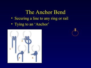
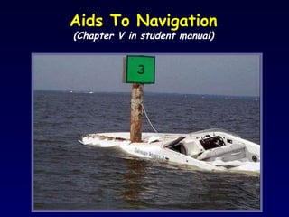
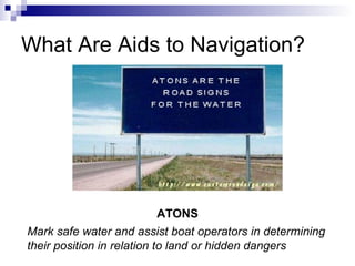
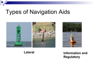
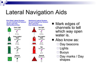
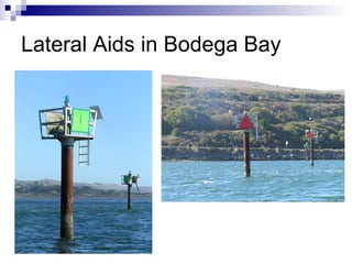
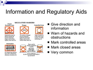
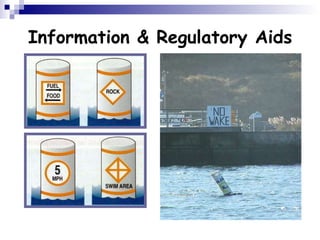
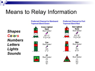
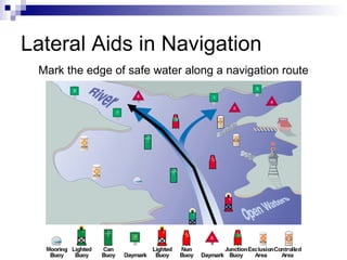
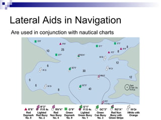
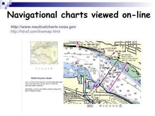
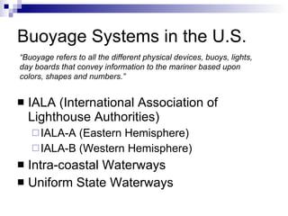
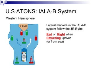
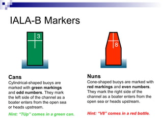
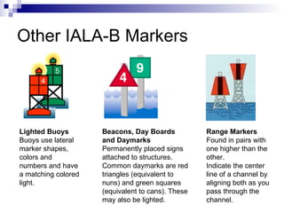
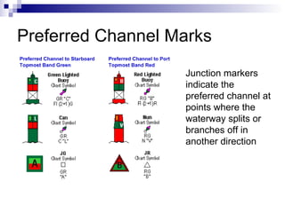
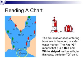
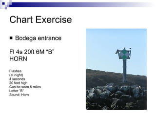
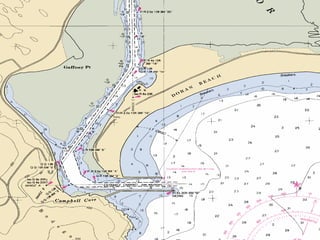
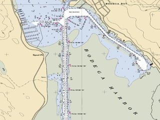
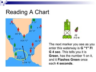
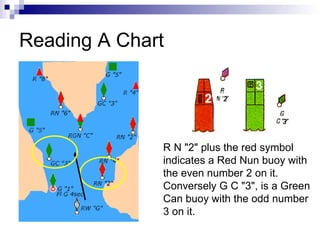
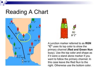
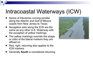
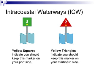
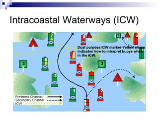
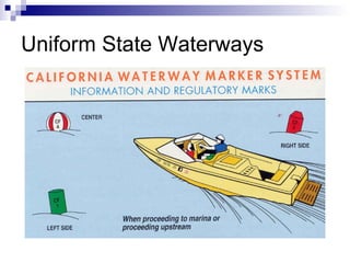
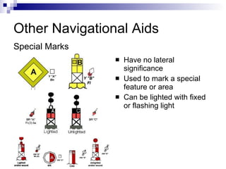
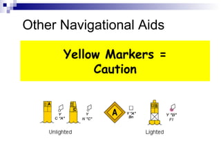
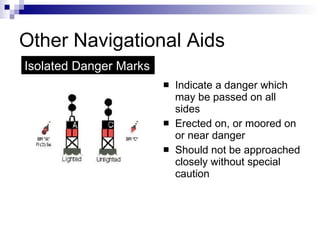
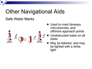
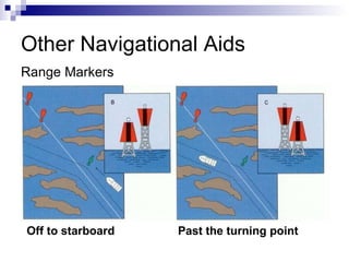
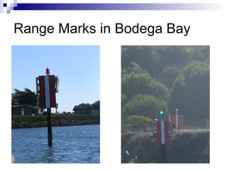
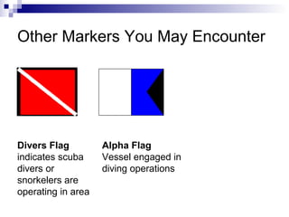
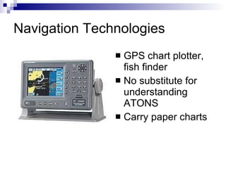
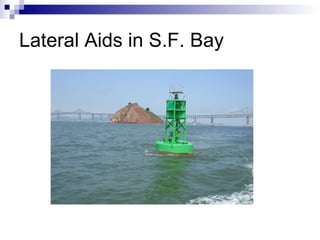
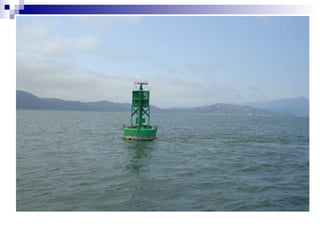
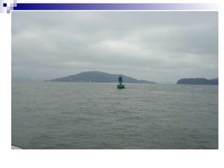
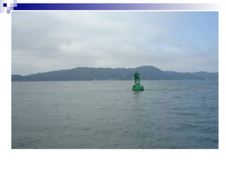
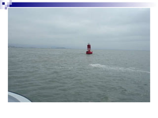
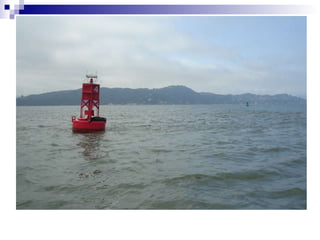
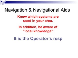
The Anchor Bend Securing a line to any ring or rail Tying to an ‘Anchor’
Aids To Navigation (Chapter V in student manual)
What we will cover… What are Aids to Navigation (ATONS)? Types of navigation aids Buoyage systems in the U.S. U.S. ATONS: IALA-B System Reading a chart Other buoyage systems encountered Other navigation aids encountered
What Are Aids to Navigation? Mark safe water and assist boat operators in determining their position in relation to land or hidden dangers ATONS
Types of Navigation Aids Lateral Information and Regulatory
Used in conjunction with Navigation Charts
Lateral Navigation Aids Mark edges of channels to tell which way open water is.  Also know as: Day beacons Lights Buoys Day marks / Day shapes
Lateral Aids in Bodega Bay
 
Lateral Navigation Aids Mark edges of channels to tell which way open water is.  Also know as: Day beacons Lights Buoys Day marks / Day shapes
 
Information and Regulatory Aids Give direction and information Warn of hazards and obstructions Mark controlled areas Mark closed areas Very common
Information & Regulatory Aids
Means to Relay Information Shapes C o l o r s Numbers Letters Lights Sounds
Lateral Aids in Navigation Mark the edge of safe water along a navigation route
Lateral Aids in Navigation Are used in conjunction with nautical charts
Navigational charts viewed on-line http:// www.nauticalcharts.noaa.gov http://hd-sf.com/livemap.html
Buoyage Systems in the U.S. IALA (International Association of Lighthouse Authorities) IALA-A (Eastern Hemisphere) IALA-B (Western Hemisphere) Intra-coastal Waterways Uniform State Waterways “ Buoyage refers to all the different physical devices, buoys, lights, day boards that convey information to the mariner based upon colors, shapes and numbers.”
U.S ATONS: IALA-B System Western Hemisphere Lateral markers in the IALA-B system follow the  3R Rule : Red  on  Right  when  Returning  upriver  (or from sea)
IALA-B Markers Cans Cylindrical-shaped buoys are marked with  green markings  and  odd numbers . They mark the left side of the channel as a boater enters from the open sea or heads upstream. Hint: “7Up” comes in a green can. Nuns Cone-shaped buoys are marked with  red markings  and  even numbers . They mark the right side of the channel as a boater enters from the open sea or heads upstream. Hint: “V8” comes in a red bottle.
Other IALA-B Markers Lighted Buoys Buoys use lateral marker shapes, colors and numbers and have a matching colored light.  Beacons, Day Boards and Daymarks Permanently placed signs attached to structures. Common daymarks are red triangles (equivalent to nuns) and green squares (equivalent to cans). These may also be lighted.  Range Markers Found in pairs with one higher than the other.  Indicate the center line of a channel by aligning both as you pass through the channel.
Preferred Channel Marks Junction markers indicate the preferred channel at points where the waterway splits or branches off in another direction
Reading A Chart The first marker seen entering from sea is the open, or safe water marker. The  RW "G"  means that it is a  Red  and  White striped  marker with, in this case, the letter  "G"  on it.  or
Chart Exercise Bodega entrance Fl 4s 20ft 6M “B”  HORN Flashes  (at night)  4 seconds 20 feet high Can be seen 6 miles Letter “B” Sound: Horn
 
 
Reading A Chart The next marker you see as you enter this waterway is  G "1" Fl G 4 sec . This tells you it is  Green , has the number  1  on it, and it  Flashes Green  once each  4 seconds .
Reading A Chart R N "2" plus the red symbol indicates a Red Nun buoy with the even number 2 on it. Conversely G C "3", is a Green Can buoy with the odd number 3 on it.
Reading A Chart A junction marker referred to as  RGN "C"  uses its top color to show the primary channel ( Red and Green Nun  buoy). Use the top color and shape as if it were a stand alone marker if you want to follow the primary channel. In this case leave the Red Nun to the right. Otherwise use the bottom color.
Other Buoyage Systems IALA-B Intra-coastal waterways (ICW) Uniform State Waterways
Intracoastal Waterways (ICW) Series of tributaries running parallel along the Atlantic and Gulf of Mexico coasts from New Jersey to Texas Navigation aids along the ICW are the same as any other U.S. Waterway with the exception of yellow markings The yellow markings override the shape or color of the lateral markers they are affixed on Red, right, returning also applies to the ICW markers Generally  South  is considered returning
Intracoastal Waterways (ICW) Yellow Squares  indicate you should keep this marker on your port side.  Yellow Triangles  indicate you should keep this marker on your starboard side.
Intracoastal Waterways (ICW)
Uniform State Waterways
Other Navigational Aids Have no lateral significance Used to mark a special feature or area Can be lighted with fixed or flashing light Special Marks
Yellow Markers = Caution Other Navigational Aids
Other Navigational Aids Indicate a danger which may be passed on all sides Erected on, or moored on or near danger Should not be approached closely without special caution Isolated Danger Marks
Other Navigational Aids Used to mark fairways, mid-channels, and offshore approach points Unobstructed water on all sides May be lettered, and may be lighted with a white light Safe Water Marks
Other Navigational Aids Range Markers Off to starboard Past the turning point
Range Marks in Bodega Bay
Other Markers You May Encounter Divers Flag  indicates scuba divers or snorkelers are operating in area Alpha Flag Vessel engaged in diving operations
Navigation Technologies GPS chart plotter, fish finder No substitute for understanding ATONS Carry paper charts
ATON systems are NOT fail safe. Buoys can move / break mooring Shore-based markings can be obstructed (ie truck) This is an introductory course. If you need to rely on an ATON System, know how to use it  before  you are on the water.
Know which systems are used in your area. In addition, be aware of “local knowledge” Navigation & Navigational Aids
Fl R 15s 50ft HORNS Priv
 
 
Lateral Aids in S.F. Bay


Know which systems are used in your area. In addition, be aware of “local knowledge” It is the Operator’s responsibility to navigate safely and effectively Navigation & Navigational Aids
The Anchor Bend Securing a line to any ring or rail Tying to an ‘Anchor’

#5 aton chris r 201107

  • 1.
    The Anchor BendSecuring a line to any ring or rail Tying to an ‘Anchor’
  • 2.
    Aids To Navigation(Chapter V in student manual)
  • 3.
    What we willcover… What are Aids to Navigation (ATONS)? Types of navigation aids Buoyage systems in the U.S. U.S. ATONS: IALA-B System Reading a chart Other buoyage systems encountered Other navigation aids encountered
  • 4.
    What Are Aidsto Navigation? Mark safe water and assist boat operators in determining their position in relation to land or hidden dangers ATONS
  • 5.
    Types of NavigationAids Lateral Information and Regulatory
  • 6.
    Used in conjunctionwith Navigation Charts
  • 7.
    Lateral Navigation AidsMark edges of channels to tell which way open water is. Also know as: Day beacons Lights Buoys Day marks / Day shapes
  • 8.
    Lateral Aids inBodega Bay
  • 9.
  • 10.
    Lateral Navigation AidsMark edges of channels to tell which way open water is. Also know as: Day beacons Lights Buoys Day marks / Day shapes
  • 11.
  • 12.
    Information and RegulatoryAids Give direction and information Warn of hazards and obstructions Mark controlled areas Mark closed areas Very common
  • 13.
  • 14.
    Means to RelayInformation Shapes C o l o r s Numbers Letters Lights Sounds
  • 15.
    Lateral Aids inNavigation Mark the edge of safe water along a navigation route
  • 16.
    Lateral Aids inNavigation Are used in conjunction with nautical charts
  • 17.
    Navigational charts viewedon-line http:// www.nauticalcharts.noaa.gov http://hd-sf.com/livemap.html
  • 18.
    Buoyage Systems inthe U.S. IALA (International Association of Lighthouse Authorities) IALA-A (Eastern Hemisphere) IALA-B (Western Hemisphere) Intra-coastal Waterways Uniform State Waterways “ Buoyage refers to all the different physical devices, buoys, lights, day boards that convey information to the mariner based upon colors, shapes and numbers.”
  • 19.
    U.S ATONS: IALA-BSystem Western Hemisphere Lateral markers in the IALA-B system follow the 3R Rule : Red on Right when Returning upriver (or from sea)
  • 20.
    IALA-B Markers CansCylindrical-shaped buoys are marked with green markings and odd numbers . They mark the left side of the channel as a boater enters from the open sea or heads upstream. Hint: “7Up” comes in a green can. Nuns Cone-shaped buoys are marked with red markings and even numbers . They mark the right side of the channel as a boater enters from the open sea or heads upstream. Hint: “V8” comes in a red bottle.
  • 21.
    Other IALA-B MarkersLighted Buoys Buoys use lateral marker shapes, colors and numbers and have a matching colored light. Beacons, Day Boards and Daymarks Permanently placed signs attached to structures. Common daymarks are red triangles (equivalent to nuns) and green squares (equivalent to cans). These may also be lighted. Range Markers Found in pairs with one higher than the other. Indicate the center line of a channel by aligning both as you pass through the channel.
  • 22.
    Preferred Channel MarksJunction markers indicate the preferred channel at points where the waterway splits or branches off in another direction
  • 23.
    Reading A ChartThe first marker seen entering from sea is the open, or safe water marker. The RW "G" means that it is a Red and White striped marker with, in this case, the letter "G" on it. or
  • 24.
    Chart Exercise Bodegaentrance Fl 4s 20ft 6M “B” HORN Flashes (at night) 4 seconds 20 feet high Can be seen 6 miles Letter “B” Sound: Horn
  • 25.
  • 26.
  • 27.
    Reading A ChartThe next marker you see as you enter this waterway is G "1" Fl G 4 sec . This tells you it is Green , has the number 1 on it, and it Flashes Green once each 4 seconds .
  • 28.
    Reading A ChartR N "2" plus the red symbol indicates a Red Nun buoy with the even number 2 on it. Conversely G C "3", is a Green Can buoy with the odd number 3 on it.
  • 29.
    Reading A ChartA junction marker referred to as RGN "C" uses its top color to show the primary channel ( Red and Green Nun buoy). Use the top color and shape as if it were a stand alone marker if you want to follow the primary channel. In this case leave the Red Nun to the right. Otherwise use the bottom color.
  • 30.
    Other Buoyage SystemsIALA-B Intra-coastal waterways (ICW) Uniform State Waterways
  • 31.
    Intracoastal Waterways (ICW)Series of tributaries running parallel along the Atlantic and Gulf of Mexico coasts from New Jersey to Texas Navigation aids along the ICW are the same as any other U.S. Waterway with the exception of yellow markings The yellow markings override the shape or color of the lateral markers they are affixed on Red, right, returning also applies to the ICW markers Generally South is considered returning
  • 32.
    Intracoastal Waterways (ICW)Yellow Squares indicate you should keep this marker on your port side. Yellow Triangles indicate you should keep this marker on your starboard side.
  • 33.
  • 34.
  • 35.
    Other Navigational AidsHave no lateral significance Used to mark a special feature or area Can be lighted with fixed or flashing light Special Marks
  • 36.
    Yellow Markers =Caution Other Navigational Aids
  • 37.
    Other Navigational AidsIndicate a danger which may be passed on all sides Erected on, or moored on or near danger Should not be approached closely without special caution Isolated Danger Marks
  • 38.
    Other Navigational AidsUsed to mark fairways, mid-channels, and offshore approach points Unobstructed water on all sides May be lettered, and may be lighted with a white light Safe Water Marks
  • 39.
    Other Navigational AidsRange Markers Off to starboard Past the turning point
  • 40.
    Range Marks inBodega Bay
  • 41.
    Other Markers YouMay Encounter Divers Flag indicates scuba divers or snorkelers are operating in area Alpha Flag Vessel engaged in diving operations
  • 42.
    Navigation Technologies GPSchart plotter, fish finder No substitute for understanding ATONS Carry paper charts
  • 43.
    ATON systems areNOT fail safe. Buoys can move / break mooring Shore-based markings can be obstructed (ie truck) This is an introductory course. If you need to rely on an ATON System, know how to use it before you are on the water.
  • 44.
    Know which systemsare used in your area. In addition, be aware of “local knowledge” Navigation & Navigational Aids
  • 45.
    Fl R 15s50ft HORNS Priv
  • 46.
  • 47.
  • 48.
  • 49.
  • 50.
  • 51.
  • 52.
  • 53.
  • 54.
  • 55.
    Know which systemsare used in your area. In addition, be aware of “local knowledge” It is the Operator’s responsibility to navigate safely and effectively Navigation & Navigational Aids
  • 56.
    The Anchor BendSecuring a line to any ring or rail Tying to an ‘Anchor’

Editor's Notes

  • #2 Introduce the topic and purpose of Nav Aids.
  • #3 Introduce the topic and purpose of Nav Aids.
  • #7 Present the information.
  • #14 Point out that these aids are typically self explanatory.
  • #18 Just an example.
  • #35 Being merged with the IALA-B system. Becomes official at the end of this year. Black buoys have been changed to green. Still usually found in pairs.
  • #37 Present the point.