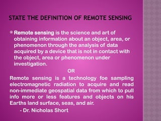
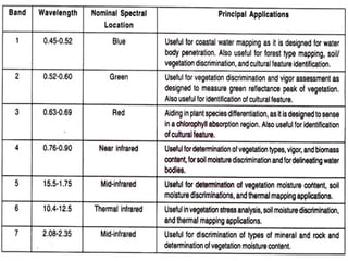
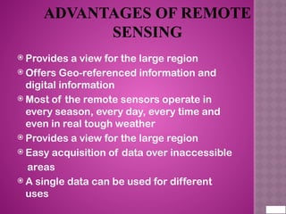
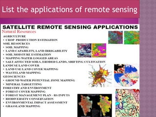
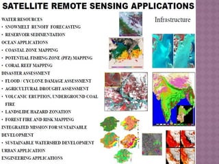
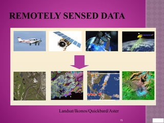
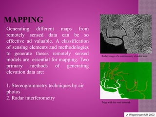
REMOTE SENSING
WHAT IS REMOTE SENSING USED FOR?
Remote means far away.
Sensing: Acquiring information of objects without
touching it.
Remote sensing is a method for getting information
about of different objects on the planet, without any
physical contacts with it.
Image Source: cimss.ssec.wisc.edu
STATE THE DEFINITION OF REMOTE SENSING
 Remote sensing is the science and art of
obtaining information about an object, area, or
phenomenon through the analysis of data
acquired by a device that is not in contact with
the object, area or phenomenon under
investigation.
OR
Remote sensing is a technology foe sampling
electromagnetic radiation to acquire and read
non-immediate geospatial data from which to pull
info more or less features and objects on his
Earths land surface, seas, and air.
- Dr. Nicholas Short
What are the seven elements involved in
electromagnetic spectrum. Explain them
WHAT IS ACTIVE AND PASSIVE REMOTE SENSING
SENSORS?
Electro magnetic radiation
ADVANTAGES OF REMOTE
SENSING
 Provides a view for the large region
 Offers Geo-referenced information and
digital information
 Most of the remote sensors operate in
every season, every day, every time and
even in real tough weather
 Provides a view for the large region
 Easy acquisition of data over inaccessible
areas
 A single data can be used for different
uses
List the applications of remote sensing
REMOTELY SENSED DATA
15
Landsat/Ikonos/Quickbard/Aster
APPLICATION OF REMOTE
SENSING
Land Use
Land cover means any surface cover on the ground which
can include vegetation, urban infrastructure, water, lake,
mountain, transportation networks, buildings or any other.
The attributes measured by remote sensing techniques
relate to land cover, from which land use can be inferred,
particularly with ancillary data or a priori cognition.
MAPPING
Generating different maps from
remotely sensed data can be so
effective ad valuable. A classification
of sensing elements and methodologies
to generate theses remotely sensed
models are essential for mapping. Two
primary methods of generating
elevation data are:
1. Stereogrammetry techniques by air
photos
2. Radar interferometry
Radar image of a continuously clouded area
Map with the road network
 Wageningen UR 2002
24_Remote Sensing  knowledge and review...

24_Remote Sensing knowledge and review...

  • 1.
  • 2.
    WHAT IS REMOTESENSING USED FOR? Remote means far away. Sensing: Acquiring information of objects without touching it. Remote sensing is a method for getting information about of different objects on the planet, without any physical contacts with it. Image Source: cimss.ssec.wisc.edu
  • 3.
    STATE THE DEFINITIONOF REMOTE SENSING  Remote sensing is the science and art of obtaining information about an object, area, or phenomenon through the analysis of data acquired by a device that is not in contact with the object, area or phenomenon under investigation. OR Remote sensing is a technology foe sampling electromagnetic radiation to acquire and read non-immediate geospatial data from which to pull info more or less features and objects on his Earths land surface, seas, and air. - Dr. Nicholas Short
  • 4.
    What are theseven elements involved in electromagnetic spectrum. Explain them
  • 6.
    WHAT IS ACTIVEAND PASSIVE REMOTE SENSING SENSORS?
  • 10.
  • 11.
    ADVANTAGES OF REMOTE SENSING Provides a view for the large region  Offers Geo-referenced information and digital information  Most of the remote sensors operate in every season, every day, every time and even in real tough weather  Provides a view for the large region  Easy acquisition of data over inaccessible areas  A single data can be used for different uses
  • 13.
    List the applicationsof remote sensing
  • 15.
  • 16.
    APPLICATION OF REMOTE SENSING LandUse Land cover means any surface cover on the ground which can include vegetation, urban infrastructure, water, lake, mountain, transportation networks, buildings or any other. The attributes measured by remote sensing techniques relate to land cover, from which land use can be inferred, particularly with ancillary data or a priori cognition.
  • 17.
    MAPPING Generating different mapsfrom remotely sensed data can be so effective ad valuable. A classification of sensing elements and methodologies to generate theses remotely sensed models are essential for mapping. Two primary methods of generating elevation data are: 1. Stereogrammetry techniques by air photos 2. Radar interferometry Radar image of a continuously clouded area Map with the road network  Wageningen UR 2002