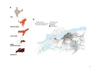
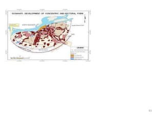
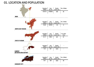
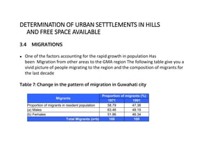
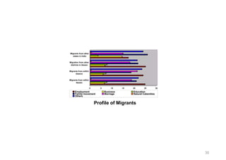
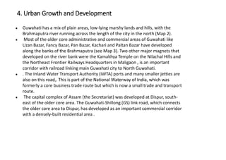
Guwahati is the largest city and capital of Assam, India, located along the Brahmaputra River. It has experienced rapid population growth in recent decades due to migration from rural Assam and other states for employment opportunities from industrialization and infrastructure projects. The city's economy is centered around industry such as oil refining and tertiary sector jobs, though many residents, especially women, work in low-paying services.
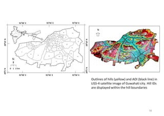
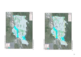
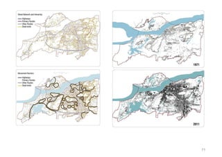
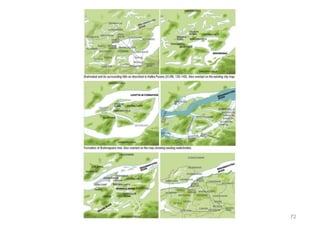
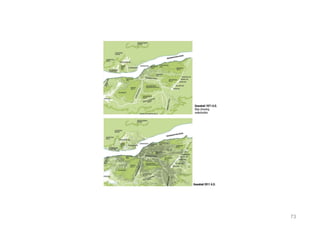
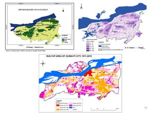
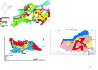
Challenges for Self-Sustainable Smart Cities in IndiaIRJET Journal
The document discusses challenges for developing self-sustainable smart cities in India, using Bilaspur as a case study. Rapid urbanization in Bilaspur has led to haphazard growth, increased resource demands, and loss of green cover. Bilaspur relies heavily on groundwater resources and surface water sources located over 26km away. However, this endangers the agricultural lands and farmers in the surrounding regions that rely on these same water sources. For smart cities to be truly sustainable, they must aim for self-sufficiency, reduce their resource demands on surrounding regions through recycling and reuse, and mitigate their environmental impacts on the periphery through reduced pollution and degradation.
The document outlines the master plan for Guwahati Metropolitan area, including objectives to develop infrastructure while conserving the environment, and details on land use, population growth, transportation networks, and strategies to address issues like flooding and traffic congestion. Zoning regulations and development controls are proposed to guide growth in a sustainable manner over the period to 2025. Institutional roles and financing options are also covered.
IRJET-About Urban Sprawl: A Case Study of Ahmedabad CityIRJET Journal
This document discusses urban sprawl in Ahmedabad City, India. It defines urban sprawl as excessive metropolitan decentralization or suburbanization that results in low density settlements and a decentralized pattern of growth. The document examines urban sprawl in Chandkheda and Kathwada neighborhoods on the edge of Ahmedabad City. Both areas are experiencing population growth and loss of agricultural land to housing and industry. This uncontrolled growth leads to issues like increased traffic, air and water pollution, and stress on resources. Solutions discussed include smart growth practices like mixed use development and improved transit to reduce sprawl's negative environmental impacts.
This document provides information on various topics related to humanities, including urbanization in India and globally, smart cities, infrastructure development in India focusing on Mumbai, characteristics of ideal open public spaces, patterns of urbanization in India, culture of Mumbai city, public housing and slum development in Mumbai, trends and pace of urbanization in India, and migration. It discusses issues like unemployment, housing, pollution, and lack of infrastructure facing urban areas in India. It also explains concepts like smart cities, types of slums in Mumbai like chawls and definitions of urban area used in India.
The concept of urban fringe and its transformation due to urbanization- A cas...IRJET Journal
This document discusses the urbanization of Jabalpur, India and its effects on the city's fringe areas. It notes that uncontrolled urban expansion has led to residential, commercial, and industrial development outside the municipal boundaries, transforming originally rural settlements into urban or mixed rural-urban areas. The study aims to evaluate development plans for Jabalpur's urban fringe areas and examine factors influencing changes in land use and development patterns. It analyzes the characteristics of development in Jabalpur's outer fringe areas and variables affecting it to develop a planning strategy to facilitate orderly development of these areas.
This document discusses strategies for sustainable and smart urban transportation in India. It notes that rapid urbanization is increasing traffic volumes and congestion in Indian cities. Current transportation patterns are problematic, involving many vehicle types competing for limited road space. This leads to issues like congestion, pollution, and accidents. The document advocates strategies like compact urban planning centered around public transit, promoting non-motorized transport, road pricing, and modern traffic management to make transportation more sustainable, efficient, and supportive of urban mobility needs.
The document provides information about Aya Nagar, a settlement located in South Delhi. It discusses the location and connectivity of Aya Nagar, noting distances from major transport hubs. It also outlines the history and growth of Aya Nagar from a village to a large urban settlement. Issues facing Aya Nagar are discussed, such as lack of adequate housing, infrastructure like roads and drainage, education and healthcare facilities. The document proposes various solutions and projects to address these issues in a sustainable manner through community participation and improved governance.
Riverfront Development- A tool to Improve and restore urban green spacesIRJET Journal
This document discusses riverfront development as a tool to improve urban green spaces. It focuses on developing the riverfront areas in the west and southwest zones of Surat City, India. The objectives are to study the existing riverfront scenario, improve the quality of urban areas and riverfront neighborhoods, safeguard future green spaces, and create public spaces and amenities for sociocultural life through a master plan for riverfront development. Issues with the current development include poor communities living along the riverbanks in inadequate housing that floods, and industrial and domestic waste polluting the river.
The document discusses urbanization trends in India and concepts related to city planning. It notes that cities are growing rapidly and expanding into surrounding rural areas. Regional planning is becoming more important, with the metropolitan region defined as the city and surrounding suburbs and rural areas. Peripheral regions beyond metropolitan regions are also influenced by cities through economic and social ties. Small towns play an important role as service centers for rural hinterlands, and future planning needs to consider the relationships between cities and the regions and hinterlands they serve.
Development of Mass Rapid Transit System- Necessity of Lucknow CityIRJET Journal
This document discusses the need for a mass rapid transit system in Lucknow, India. It notes that the city's population and number of vehicles have grown rapidly in recent decades, leading to increased traffic congestion. Specifically, the core areas of the city like Chowk are densely populated with narrow streets, limiting connectivity. A survey found that many original residents of Chowk have migrated to newer areas of the city due to issues like traffic, parking and lack of public transportation access. The document argues that a mass transit system is needed to better connect the core areas to the rest of Lucknow to help preserve the cultural heritage and reduce overcrowding issues. It provides Delhi's metro system as an example of an effective mass transit solution
Strategies for Promoting Urban SustainabilityJIT KUMAR GUPTA
Indian strategies are needed to manage global warming through ruralization and rational urbanization. Regional planning can help integrate urban and rural settlements to minimize migration and make development more sustainable. Urban planning must be redefined and reinforced to make cities more compact and sustainable through vertical development and transit-oriented design. Public transportation, cycling, and road pricing can promote sustainable mobility. Green buildings and smart technologies can reduce energy use and emissions from the built environment. Ruralization is also important as rural areas still house most of India's population and are inextricably linked to urban and national development.
IRJET - A Study of Existing Scenario based on Reconnaissance Survey: A Case ...IRJET Journal
This document summarizes a study on the existing scenario of the walled city of Surat, India based on a reconnaissance survey. It finds that while Surat has experienced high urban development and economic growth, the walled city area is characterized by inadequate infrastructure, poor living conditions, and traffic congestion. Through the reconnaissance survey, the study collected data on land use, religious characteristics, roads, open spaces, heritage sites, slums, and social and physical infrastructure in the walled city. The goal of the study is to inform revitalization planning efforts that can improve residents' living standards and social cohesion while maintaining the walled city's character.
The document discusses a spatial analysis of the Detailed Area Plan (DAP) of Chittagong city in relation to its contribution towards the economic sustainability of the city through commercial and industrial land use. It provides background on Chittagong's history as a port city and its rapid urban growth. The research aims to examine how the DAP's spatial configuration and allocation of land for commercial and industrial purposes impacts the city's economic sustainability, according to theories of urban design and cities as movement economies.
The document discusses a spatial analysis of the Detailed Area Plan (DAP) of Chittagong city in relation to its commercial and industrial land use and economic sustainability. It provides background on Chittagong's history as a port city and trade center. The research aims to examine how the DAP contributes to the city's economic sustainability through its land use designations and spatial configuration based on the theory of cities as movement economies. The methodology will analyze the physical city structures and land uses set out in the DAP and their ability to support a sustainable functional city from an economic perspective.
This document is a thesis by Ritam Niyogi submitted to the University of Manitoba in October 2021. It examines the creation of urban symbiosis through improving living conditions for residents of the Kalighat slum settlement located along the banks of the Adi Ganga canal in Kolkata, India. The thesis will focus on addressing environmental issues like flooding through sustainable design and planning interventions while also enhancing housing, community spaces, and economic opportunities for slum dwellers. Case studies on vernacular architecture, waste management systems, and previous slum rehabilitation projects are analyzed. The proposed design will utilize locally sourced bamboo and involve slum residents in construction to provide flexible, expandable housing units integrated with the natural landscape.
The document provides an overview of the city development plan for Solapur, India up to 2041. It discusses the city's history, demographics, infrastructure needs, and strategies for economic development. Key points include:
- Solapur has experienced slow growth since the previous development plan in 1997, with only 17% additional area developed by 2014 versus what was planned.
- The city faces infrastructure deficits in areas like water supply, sewerage, solid waste management, and transportation.
- Strategies to boost the economy include improving basic infrastructure, reforming taxes, leveraging public-private partnerships, and dedicating city buses to industrial workers.
- An investment of 1,749 crores is required
The document discusses urban development and sanitation in India. It notes that India's urban population is growing rapidly and will reach 50% by 2050, putting pressure on resources. Improving water supply and sanitation was identified as a key priority by Prime Minister Modi. The government has launched various initiatives like JNNURM and AMRUT to invest in urban infrastructure development in 500 cities and towns, with a focus on water supply, sewerage, roads, drainage and solid waste management. Only 2 cities currently have continuous water supply and many Indians lack access to improved sanitation facilities.
This document provides details on the proposed urban planning project called "Satiated Town". The vision is to create a sustainable community that provides a good quality of life while minimizing environmental impact. Key aspects include using locally-grown pistachio trees as a main crop and focus on themes of food and sense of place. The master plan divides the town into 6 neighborhoods arranged around a central ring road. Design goals are to integrate transportation and land use, respond to the arid climate, promote high density with public transit, and encourage walkability. Sustainability strategies address passive design, energy/water management, and using agricultural byproducts.
Sustainable resource use and Urban Infrastructure - learning from the past or...Surabhi Bharadwaj
This document discusses sustainable infrastructure and resource use. It begins by summarizing examples from history where civilizations collapsed due to overreliance on single resources, including the Indus Valley civilization and Roman Empire. It then examines modern examples like Detroit and Mumbai that face challenges from unsustainable growth. The document argues that societies can avoid repeating history by adopting principles of eco-efficiency to delink development from environmental impacts. It provides indicators for measuring sustainable use of key resources like water, energy, transport and information. Overall, the document advocates for changing attitudes and planning approaches to create sustainable infrastructure that respects both future and past generations.
This presentation was given by SPA Bhopal for "Samavesh" - XVl Annual NOSPlan Convention. The Theme of Presentation - "Accessibility in Peri-urban area".
Rural Roads as Infrastructure for Economic DevelopmentIram Aziz
The document discusses the lack of rural infrastructure in India and its negative impacts. It notes that over 70% of India's rural population lacks access to basic infrastructure and the national economy. This is due to insufficient rural roads, markets, transportation, and other facilities. As a result, rural populations face limited livelihood opportunities, agricultural stagnation, and high levels of poverty. The document argues that a public-private partnership approach to rural infrastructure development is needed to open new business opportunities for both corporations and rural communities.
This document provides a land use plan for Karaikal Town from 2012-2033. It analyzes the existing land use pattern and compares it to norms. Residential makes up over 50% of the developed area currently but is proposed to increase to 51% by 2033. Commercial and industrial land is proposed to increase to better support the economy. Public/semi-public land is proposed to decrease slightly while recreation land increases significantly to meet needs. The plan divides the town into zones and allocates land uses to achieve a balanced development across zones.
The document discusses the planning and evolution of two satellite towns of Delhi - Gurugram and Noida. It provides details on the master plans developed for Gurugram (2021, 2025, 2031) and Noida (1991, 2001, 2021, 2031) which planned for increasing populations and land usage over time. While both towns aimed to decongest Delhi, analysis shows Gurugram lacked public transportation connectivity and basic infrastructure services, whereas Noida invested more in transportation networks like DMRC and water management.
A brief overview of the negative outcomes and environmental challenges of rapid urban growth using the example of Bengaluru, India. Also looks at means to solve these problems and secure a sustainable future.
This document discusses smart city investment and economics. It covers key areas of investment for smart cities, including land, power, water, highway/road connectivity, and fuel pipelines. It then discusses various economic models related to local economic development, including prehistoric, conventional linear, pre-industrial, and technopoles models. It also covers principles of competitiveness in new urban economies and the relationship between urbanization, cities, and economic growth.
Good Practice Urban Agriculture and Better Built Environment in India
`
For more information, Please see websites below:
`
Organic Edible Schoolyards & Gardening with Children
http://scribd.com/doc/239851214
`
Double Food Production from your School Garden with Organic Tech
http://scribd.com/doc/239851079
`
Free School Gardening Art Posters
http://scribd.com/doc/239851159`
`
Increase Food Production with Companion Planting in your School Garden
http://scribd.com/doc/239851159
`
Healthy Foods Dramatically Improves Student Academic Success
http://scribd.com/doc/239851348
`
City Chickens for your Organic School Garden
http://scribd.com/doc/239850440
`
Simple Square Foot Gardening for Schools - Teacher Guide
http://scribd.com/doc/239851110
Issues and options for raising Resources for Financing infrastructure in Ur...JIT KUMAR GUPTA
Considering role and importance of infrastructure, Paper makes an attempt to bring out the options to raise resources to make available urban infrastructure to all in urban India
The document provides an overview of land use and urban planning in Allahabad city, India. It describes the administrative boundaries and location of the city. The existing urban setting is classified into the old city, new city, and outgrown areas. Land use is analyzed according to the Allahabad Master Plan 2001, which allocated land for residential, commercial, industrial, recreational, and other uses. Key issues discussed include lack of industrial land usage, shortage of recreational areas, increasing population and housing needs, the presence of slums, and inadequate transportation and social infrastructure.
The document analyzes an urban neighborhood called CIDCO N1 in Aurangabad, India. It summarizes the climate, which is semi-arid with average annual rainfall of 710mm mostly during monsoons. It then describes the neighborhood's planned development with residential, commercial, and public buildings as well as open spaces. Finally, it evaluates the hierarchy of open spaces, changes in land use over time, hierarchy of roads, and existing vegetation on the site.
The document analyzes an urban neighborhood in Aurangabad, Maharashtra, India. It describes the location, climate, land uses, and open spaces of the neighborhood. The neighborhood has an irregular shape and coarse grain texture due to organic growth. It consists of residential, commercial, mixed-use, and public/semi-public buildings as well as some open spaces. However, there are only two small, underdeveloped parks and no community-level parks despite guidelines requiring more open spaces. The document also evaluates the road network and vegetation in the area.
The first five-year plan in India aimed to improve public health, build rural health services, and enhance the general health status of the population. A total budget of Rs. 2,069 crore was allocated, with the largest shares going to irrigation/energy and transport/communications. In health, priorities included water/sanitation, malaria control, and health services for mothers and children. The plan achieved most of its targets through investments in agriculture, energy and infrastructure development.
This document discusses various elements of urban design including urban blocks, neighborhoods, public realm, streets, markets, squares, open spaces, and landscapes. It defines these terms and provides examples. Some key points include:
- Urban blocks are subdivided areas within a city street pattern used for building construction that aim to create self-sufficient neighborhoods with basic facilities.
- Clarence Perry identified six principles for neighborhood unit design including central community centers, local shops at corners, parks making up 10% of space, and arterial streets bounding the area.
- Public realm comprises streets, squares, parks and other outdoor places that the public can freely access without charge.
- Markets are gatherings for buying and selling goods and take
This document outlines a proposed strategy for training rural stakeholders in India during the 12th Five Year Plan period from 2013-2017. The strategy aims to create a multilayered knowledge dissemination system and train rural people for sustainable livelihoods. Key objectives include establishing a pool of trained volunteers and creating information centers at different administrative levels. The organizational structure would establish autonomous training institutes across states based on a uniform model. Infrastructure would be developed to support residential training of 125 people per day. Distance learning methods like satellite communication would also be used. The current strengths and weaknesses are assessed, and an implementation plan and evaluation strategy are proposed to achieve the vision of inclusive growth and empowering rural India.
This document contains a list of channel numbers from 1 to 4 and drainage basin numbers from 1 to 29. It appears to be providing an inventory or index of channels and drainage basins within a certain area, likely for analysis and modeling of water flow.
The document contains information about various planets in the solar system presented in different visual formats including paragraphs of text, images, graphs, tables, timelines, and infographics. It discusses the properties of planets such as Mercury, Venus, Earth, Mars, Jupiter, and Saturn. The purpose seems to be to demonstrate different ways of presenting conceptual information visually through various media like text, images, graphs, and more.
- Guwahati is the capital city of Assam and has experienced rapid population growth, rising from around 500,000 in 1971 to over 1 million in 2011.
- It is a major economic hub for the region, with industries like oil and gas driving growth. However, poverty and unemployment remain issues, especially for female workers.
- The city has seen significant migration over the years from other parts of India and Bangladesh, fueling tensions over resources and identity.
- Urban growth has occurred largely along the Brahmaputra River as well as through filling in wetlands and development in the hills, displacing poorer residents and damaging the environment.
- Governance of the city is shared between the Guwa
This document discusses topographically sensitive urbanism and re-envisioning earthwork terracing in suburban development. It summarizes how some cities like Hong Kong, Rio de Janeiro, Sydney, and San Francisco have responded to steep topography with site-specific strategies that integrate the natural terrain. However, at expanding city peripheries, suburban sprawl is increasingly encroaching onto hilly areas and re-grading natural slopes into flat terraced lots, disrupting the balance between urban form and topography. The document examines how prevailing 20th century urban models of modernism, ecological planning, and traditional urban design have had limited influence over this process of mechanized suburban transformation on sloped lands.
This document outlines several theme options for a new restaurant project, including a Greek theme inspired by Santorini with blue and white colors, a metal theme for dining areas and furnishings, a Planodity theme with modern interior designs, a neutral theme with minimalist classic touches, a bohemian theme, an art deco theme, and a contemporary theme. For each theme, elevations and concepts for room interiors are presented.
The document discusses potential themes for a restaurant project, including Greek, metal, planodity, neutral, bohemian, art deco, and contemporary themes. For each theme, it provides brief descriptions of the interior design concepts, elevations, and room interior designs. A total of 28 different themes are listed and described at a high level with concepts for the restaurant interior, exterior elevations, and indoor and outdoor seating areas.
The document discusses potential themes for a restaurant project, including Greek, metal, planodity, neutral, bohemian, art deco, and contemporary themes. For each theme, it provides brief descriptions of the interior design concepts, elevations, and room interior designs. A total of 28 different themes are listed and described at a high level with concepts for the dining hall, outdoor garden, and room interior designs.
The document provides the time table for the academic year 2022-23 for the postgraduate program M.Arch (P-1) at G.S. Mandal's MIT. It lists the class schedule on a day to day basis from Monday to Saturday. Various courses are scheduled at different time slots and are taught by regular and visiting faculty members listed at the bottom along with their abbreviations. The time table also mentions class teachers for the first and second year of the M.Arch program.
Revolutionizing the Digital Landscape: Web Development Companies in Indiaamrsoftec1
Discover unparalleled creativity and technical prowess with India's leading web development companies. From custom solutions to e-commerce platforms, harness the expertise of skilled developers at competitive prices. Transform your digital presence, enhance the user experience, and propel your business to new heights with innovative solutions tailored to your needs, all from the heart of India's tech industry.
Architectural and constructions management experience since 2003 including 18 years located in UAE.
Coordinate and oversee all technical activities relating to architectural and construction projects,
including directing the design team, reviewing drafts and computer models, and approving design
changes.
Organize and typically develop, and review building plans, ensuring that a project meets all safety and
environmental standards.
Prepare feasibility studies, construction contracts, and tender documents with specifications and
tender analyses.
Consulting with clients, work on formulating equipment and labor cost estimates, ensuring a project
meets environmental, safety, structural, zoning, and aesthetic standards.
Monitoring the progress of a project to assess whether or not it is in compliance with building plans
and project deadlines.
Attention to detail, exceptional time management, and strong problem-solving and communication
skills are required for this role.
Connect Conference 2022: Passive House - Economic and Environmental Solution...TE Studio
Passive House: The Economic and Environmental Solution for Sustainable Real Estate. Lecture by Tim Eian of TE Studio Passive House Design in November 2022 in Minneapolis.
- The Built Environment
- Let's imagine the perfect building
- The Passive House standard
- Why Passive House targets
- Clean Energy Plans?!
- How does Passive House compare and fit in?
- The business case for Passive House real estate
- Tools to quantify the value of Passive House
- What can I do?
- Resources
EASY TUTORIAL OF HOW TO USE CAPCUT BY: FEBLESS HERNANEFebless Hernane
CapCut is an easy-to-use video editing app perfect for beginners. To start, download and open CapCut on your phone. Tap "New Project" and select the videos or photos you want to edit. You can trim clips by dragging the edges, add text by tapping "Text," and include music by selecting "Audio." Enhance your video with filters and effects from the "Effects" menu. When you're happy with your video, tap the export button to save and share it. CapCut makes video editing simple and fun for everyone!
Visual Style and Aesthetics: Basics of Visual Design
Visual Design for Enterprise Applications
Range of Visual Styles.
Mobile Interfaces:
Challenges and Opportunities of Mobile Design
Approach to Mobile Design
Patterns
ARENA - Young adults in the workplace (Knight Moves).pdfKnight Moves
Presentations of Bavo Raeymaekers (Project lead youth unemployment at the City of Antwerp), Suzan Martens (Service designer at Knight Moves) and Adriaan De Keersmaeker (Community manager at Talk to C)
during the 'Arena • Young adults in the workplace' conference hosted by Knight Moves.
Decormart Studio is widely recognized as one of the best interior designers in Bangalore, known for their exceptional design expertise and ability to create stunning, functional spaces. With a strong focus on client preferences and timely project delivery, Decormart Studio has built a solid reputation for their innovative and personalized approach to interior design.
Explore the essential graphic design tools and software that can elevate your creative projects. Discover industry favorites and innovative solutions for stunning design results.
Fonts play a crucial role in both User Interface (UI) and User Experience (UX) design. They affect readability, accessibility, aesthetics, and overall user perception.
2. INTRODUCTION
Guwahati, meaning “areca nut marketplace” in Assamese, was known by the name
of “Gauwahati” during the British period. It is situated along the Brahmaputra River
and is bound on the southern side by the foothills of the Shilong plateau. It is the
gateway to North-East India. It is also the business hub and largest city of Assam
and the North-East.
3. WHAT IS INDIAN URBANISM
Urbanism is the study of how population of urban areas, such as towns and cities,
interact with the built environment. India is on the verge of being emerged as the most
populated country of the world. To manage the massive urban population, smarter,
sustainable and greener cities are envisioned in India's newly adopted urbanization
policy.
3
4. WHY GUWAHATI
Guwahati derives its name from the Assamese word "Guva" derived from the Sanskrit word
Guvaka, meaning areca nut and its plant and "Hati" meaning rows, the rows of areca nut trees.
Distinctive cultures , antiquity, topography , locations makes guwahati unique.
POLITICAL , HISTORICAL & SOCIAL BACKGROUND
Guwahati is the city of eastern lights , it is rebuilded during the colonial period.
It lies between the banks of Brahmaputra and Bothills of shilong . It is the biggest city of Assam
with adoption of city master plans since 1960s
Guwahati is the largest Metropolis in north eastern region .
Dispur is the capital of Assam. It is major reverine city and a gateway to North east India.
Guwahati was the Pragjyotisha State during classical period On the Indian subcontinent . It was
the 1st historical kingdom along with the Dwarika
TOURIST & HISTORICAL PLACES
- Important ancient Hindu Temple Like Kalnakhya temple Is situated at Guwahati.
- LGB i.e. Lokpriya Gopinath Bardol international Airport Is the 12th busiest airport in India
- GMDA (guahati metropolitan development authority) is here
- Madan kamdev - archeological site that in 9th & 10th century which was ruins dated back to
pala dynasty of Kantala, is situated in Guwahati.
- IIT Guwahati
4
5. 5
VISION OF “GUWAHATI SMART CITY”
- To become food resilient city
- To be De ongested city (eco mobility corridors)
- Improve public realm of the city (infrastructure & tourism)
- Strengthen eco tourism in city
- To introduce ICT based application (monitoring system)
- Introduce sustainable planning practices
- to start skill development centres
- SOLAR CITY GUWAHATI MISSION Extended to public spaces & stand alone with high
capacity electricity generation will be targeted
- to strengthen Businesses
8. 3.4 MIGRATIONS
● One of the factors accounting for the rapid growth in population Has
been Migration from other areas to the GMA region The following table give you a
vivid picture of people migrating to the region and the composition of migrants for
the last decade
Table 7: Change in the pattern of migration in Guwahati city
DETERMINATION OF URBAN SETTTLEMENTS IN HILLS
AND FREE SPACE AVAILABLE
9. 9
3.5 URBANIZATION
Assam is one of the least urbanized States of the country, while the
share of urban population to total population of Assam in 1951 was
only 4.29% . It has increased to 12.1% in 2001 , which is still lower than
the national average of 27.78% . Even among the Northeastern States
Assam has the lowest urbanization with Mezorem at 49.5% being the
most urbanized state in the Northeastern region among all the districts
of Assam . kamrup is the most organized with 35.81% Urbanization .
Urbanization Trend for the Last Decade
Guwahati is the largest urban center in Assam with 23.89% of the total
urban population of the state Guwahati alone contributes 55% of the
combined population of the significant towns of Assam.
10. 10
The inflow of the Bharalu river is the main controlling factor of the water quality, of this water body.
Pressure of urbanization and Pollution have had the negative impact on its stability.
overall wetland degeneration has emerged as a major problem in the region caused by encroachment ,
natural salutation, Earth feeling and garbage dumping.
The list of major water bodies are enclosed below:
Bharalu basin : Bharalu river being the most fluid prone area and it is the core of the drainage system
with a catchment area of 42 km² . During heavy rainfall there is a black flow of free water
Deepar basin : single largest drainage basin covering an area of 20135 ha and is divided into 2
substations bijubari and deepar sub basin.
Borsola basin : this is another major natural drainage system is located towards the Southern part of
the city.
Silsako basin: it covers area of 6534 ha and it is connected to Bramhaputra through a stream called
bondajan.
Foreshore basin : It includes certain residential commercial institutional and business areas in
guaharti
North Guwahati basin : it covers total area of 32sq km.
Kalamoni basin : it occupies total area of 66.5 km² it finds its way to promo putra through the Kona
John and partly through thanga banga and the Khalid broke river.
12. 12
3.11 Urban Renewal Program
Guwahati metropolitan Area is a gateway to the Northeastern reason due to
its excellent connectivity and unique geographical location this region is
experiencing rapid growth of trade and Commerce and it has the potential to
become the hinter land for the dead Northeastern region
Presence of wholesale markets and industries in busy areas
The major problem of the GMA purchase 2 pressures of different types and
sizes of industries at different PC areas of the city apart from creating
congestion due to loading and unloading of goods at the these places their
presence also lead to a polluted environment
Presence of wholesale markets
In the GMA presence of wholesale markets in the heart of the city cause tremendous
congestion as roadside these markets are used for commercial activities are causing huge
congestion most of the markets are situated beside the busy roads . So all the market related
activities are takes place in the footpath area . As a result of this most of the pedestrians can
not use the footpath of the market areas this caused a large number of accidents Fancy
bazaar paltan bazaar and Pan bazaar are some of those areas.
Use a amount of garbage is also dumped every day in the markets that causes pollution and
makes roads dirty again as a market as the markets are situated in the busy areas of the cities
it also causes noise pollution
13. 13
Scarcity of Housing Due to Rise in Migration
Because of growing industries The region generates large number of employment
opportunities. So migration takes place from the front cities and villages of the
neighborhood areas. Most of these people live in slums of the cities as a result number of
slum dwellers is increasing in the area.
Presence of slums in any urban area is a visible manifestation of urban poverty this lamp
pockets develop on their own near any well established residential area or industry slums
are considered to be public health hazard because of presence of unsenatory living
conditions and lack of civil infrastructure facilities.
Presence of the jail in central city area
The city jail is right in the central area of the city the jail should be shifted to the outskirts
of the city in isolation to ensure rehabilitation of the prisoners
Along with better security for citizens.
14. 14
Fig 11 : Broad Break Up of Land Use 2001
9.3 Land Use 2025
A master plan for the city had been prepared shown the overall land
use breakup for 2025 it is understood that the master plan is under
further revision it has been estimated that approximately 5000 ha of
land is required by GMA for various urban activities by 2025.
16. 16
20 . Reform Program
20.1 Background And Reform Goals
The thrust of the JNNURM is to ensure improvement in urban Governance and service delivery so that ULBs
become financially sound and sustainable for undertaking new programs. It is also envisaged that, With the
charter of reforms that are followed by the state governments and ULb's, A stage will be set for PPP's
The agenda of reforms is given in the section Below. The national steering group (NSG) May add additional
reforms to identified reforms. A memorandum of agreement between States or UL b's or parastatel Agencies
and the government of India, A prerequisite For assisting the central assistance, Would spell out specific
milestones to be achieved for each item of reform. All mandatory and optional reforms shall be completed
within the mission.
20. 2 Reform Agenda Agenda
1. Mandatory reforms at the level of UL b's and parasite Agencies
a) Adoption of modern actual based double entry system of accounting in UL b's and parastatal agencies
b) This introduction of a system of eager governments using IT applications, Such GIS and MIS for various
services provided by UL b's and parastatal agencies
c) Reform of property tax with GIS. It becomes a major source of revenue for ULb's an Arrangement for its
effective implementation so that collection efficiency reaches at least 85% within next 7 years
d) Levy off reasonable user charges by UL b's and para state tell with the objective that the full cost of O and
M or recurring costs is collected within the next 7 years. However cities and towns in the northeast and other
special categories States may recover only 50% of O and M charges initially. These cities and towns should
graduate to full O and M cost recovery in a phased manner.
e) Internal earmarking within local bodies, Budget for basic services to the urban poor.
f) Provision of basic services to the urban poor including security of tenure at affordable prices, Improved
housing, water supply and sanitation. Delivery of other existing universal services of the government for
education, Health and social securities is ensured.
17. 17
2. Optional Reforms ( Come on to States, UL b's and parastatal agencies)
A) Television of my lost history line the approval process for construction of buildings,
Development of site etc Development of site etc
B) Inbox of conversion of land from agricultural to non agricultural purposes.
C) Introduction of property title certification system in UL b's
D) Earmarking at least 20 to 25% of developed land in all housing projects ( Both
public and private agencies) For EWS NLIG category with a system of cross
subsidization.
E) Introduction of computerized process of registration of land and property.
F) Revision of bylaws to make rain water harvesting mandatory in all buildings and
adoption of water Conservation measures.
G) Bylaws for reuse of recycled water
H) Administrative reforms that is reduction in establishment costs by adopting the
voluntary retirement scheme, Not feeling posts falling why can't you to retirement etc,
And achieving specified milestones in this regard
I) Structural reforms
J) Encouraging PPP
18. 18
Outlines of hills (yellow) and AOI (black line) in
LISS-4 satellite image of Guwahati city. Hill IDs
are displayed within the hill boundaries
19. 19
Urban settlement in hill versus—a average
slope of hill, b average elevation of hill, c
commercial unit density in AOI, d available
free space in AOI, e average land value in AOI
and f favoring index
Sensitivity of urban settlement in hills of Guwahati
city with respect to variation in explanatory
variables a commercial unit density, Cu, b free
space available in AOI, Af, c land value, Lv and d
favouring index, F
20. 20
CONCLUSIONS
Implementation of master plan in the
Guwahati city may cause the
degradation in the ecological balance
in its hilly areas , if the nature
conversation law is not implemented
in the city for socio economic and
demographic constraints. Thus , the
planned city area always experiences
multiple natural hazards like urban
flood , landslide and water pollution
due to unplanned or unautharised
settlements in the eco-sensitive area
can always help in the better future
planning of prime city area.
23. 23
•PART I •PART II
•Lays out the relevant urban context by
discussing Guwahati’s demography, its
economy and employment, the history of
migration and conflicts in Assam and
Guwahati, the processes of urban growth
and development in the city and urban
governance.
•Identifies and discusses some of the key
arenas of conflicts and violence that are
linked to land, planning and governance
regimes in the city, namely, informal
settlement of the city’s hills, street
vending and women’s safety and public
transport.
DIVISION OF CONTENT
24. 24
•PART I
•Lays out the relevant urban context by
discussing Guwahati’s demography, its
economy and employment, the history of
migration and conflicts in Assam and
Guwahati, the processes of urban growth
and development in the city and urban
governance.
DIVISION OF CONTENT
25. ● Guwahati is the capital city of Assam, which is among the states
with low level of urbanization.
● 14.1 per cent of the state’s population was living in urban areas in
2011, which is an increase from 12.9 per cent in 2001 and 11.1
per cent in 1991.
● The urbanization rate (rate of urban population growth) for Assam
for the decade of 1991-2001 was 3.3 per cent p.a, which was
higher than that of India (of 2.8 per cent p.a.).
● Guwahati witnessed a very high rate of growth in the period from
1971 to 1991; 8.1 per cent p.a., which is likely on account of the
city becoming Assam’s capital in 1972, migration from rural Assam
and other states of the North-East region of India, and also the
cross-border migration from Bangladesh after the latter’s
formation in 1972.
1. DEMOGRAPHY
27. 27
The decadal population growth in Guwahati Metropolitian
Area is nearly 37.85%
Which is substaintially higher than that of the national
decadal growth of 21.35%
31. ● Guwahati is the major hub of economic activity in the entire
North-East region.
● The establishment of Guwahati refinery in 1962 marked the
beginning of industrialization in the city.
● The construction of the bridge over Brahmaputra at Saraighat and
the shifting of the capital from Shillong to Guwahati in 1972 (as
Shillong was made capital of the newly formed Meghalaya state
carved out of Assam) made it into one of the most important
cities in the North-East.
● Regular employment among the female workers was 44.4 per cent
in urban Assam in 2011-12, which is higher proportion than
among males (35.2%) (Table 2). All this employment is likely to be
in the tertiary sector where 80 per cent of the women workers are
in urban Assam. Proportion of self-employed female workers is
46.7 per cent, which is lower than the proportion among the male
workers (55.0%). It is likely that many women are in the low-end
services such as domestic work, etc.
2. URBAN ECONOMY, POVERTY AND EMPLOYMENT
33. ● The presence of high numbers of migrants in Guwahati in 1971 can be linked to the history of
migration. In 1978 Myron Weiner wrote that Assam had been the fastest growing area in the sub-
continent for nearly 70 years (Baruah 1999).
● All of the nineteenth and early-twentieth century saw the discovery of tea, coal, oil and natural gas
in Assam. Demand for tea labour in the plantations was unfulfilled by the Assamese peasantry who
were more involved with agriculture. This fostered the first wave of migrants from Bihar and Odisha.
Called oldest “tea labour community”.also the Nepalis. Marwaris came to Assam along with the
British, to dominate the trade and commerce in the North-East. Migration promoted by the labour
demands in industries, the coal and oil fields, construction of railway line.
● migration from Bangladesh to Assam also continued due to the difficulty of monitoring the Indo-
Bangladesh border for both Hindu political immigrants and Muslim economic immigrants (Baruah
1999). Although there is a recognition that the migration is increasingly due to economic and
ecological conditions in Bangladesh .
3. HISTORY, MIGRATION AND CONFLICTS
34. ● Guwahati has a mix of plain areas, low-lying marshy lands and hills, with the
Brahmaputra river running across the length of the city in the north (Map 2).
● Most of the older core administrative and commercial areas of Guwahati like
Uzan Bazar, Fancy Bazar, Pan Bazar, Kachari and Paltan Bazar have developed
along the banks of the Brahmaputra (see Map 3). Two other major magnets that
developed on the river bank were the Kamakhya Temple on the Nilachal Hills and
the Northeast Frontier Railways Headquarters in Maligaon , is an important
corridor with railroad linking main Guwahati city to North Guwahati.
● . The Inland Water Transport Authority (IWTA) ports and many smaller jetties are
also on this road,. This is part of the National Waterway of India, which was
formerly a core business trade route but which is now a small trade and transport
route.
● The capital complex of Assam (the Secretariat) was developed at Dispur, south-
east of the older core area. The Guwahati-Shillong (GS) link road, which connects
the older core area to Dispur, has developed as an important commercial corridor
with a densely-built residential area .
4. Urban Growth and Development
35. ● Guwahati’s hills have gradually been settled by different socio-economic groups. The
displacement of tribals from Guwahati’s plains led many of them to move to the hills.
Poor and lower-income non-tribals have also increasingly gone to live in the hills. The
state has attempted to label these as “hill encroachments” and remove them in the
name of ecological concerns.
● Guwahati’s wetlands (called beel in Assamese) have also been degrading. Reasons are
natural siltation, earth filling, encroachment, and garbage dumping.. Along the
Guwahati to Dispur National Highway, Residential areas like Tarunnagar and
Lachitnagar (Bera 2011b). Areas like Six Mile and Jalukbari had wetlands. Marshy
Large settlements of the poor have emerged by filling up low-lying areas at
Bhaskarnagar near R.G. Baruah Road, and on marshy land near Pandu area (Borah &
Gogoi 2012).
37. ● There are several authorities and government departments involved in urban governance. The
main ones are Guwahati Municipal Corporation (GMC), Guwahati Metropolitan Development
Authority (GMDA) and Guwahati Development Department (GDD).
5. URBAN GOVERNANCE
38. 38
•PART II
•Identifies and discusses some of the
key arenas of conflicts and violence
that are linked to land, planning and
governance regimes in the city,
namely, informal settlement of the
city’s hills, street vending and
women’s safety and public transport.
DIVISION OF CONTENT
39. ● The settlements in the hills have been growing since the 1970s when Meghalaya was formed as a
separate state and the capital of Assam was shifted from Shillong to Dispur near Guwahati. Tribals
and other marginalized communities who were displaced from the plains as Guwahati expanded
and developed as well as poor migrants who came to the city and settled in the hills. Successive
governments accepted the presence of these settlers and provided them roads, electricity and even
water connections with taxes applied.
● According to one survey in 2011, the GMC area comprises of 16 hills on which a total of 65,894
households reside. Of these, 10,208 households were found to reside on Reserve Forest (RF) land,
40,121 households on other State government land and remaining on patta land (AC Nielson 2011).
● The Guwahati Slum Policy of 2009 identified about 24 hill settlements, having a population of
5,380 households, as slums. Further, acknowledging them as slums would result in the GMC or the
State government granting the residents some right to housing, which can be avoided if they are
not listed as slums.
6. INFORMAL SETTLEMENT OF THE HILLS
40. ● Street markets have been an important part of Guwahati’s trade and commerce since a century.
Today, nearly 30,000 street vendors sell their wares across the city according to the NGO sSTEP. The
Guwahati Municipal Corporation Act, 1971 defines market as “any place where persons assemble for
the sale and purchase of articles intended for food or drink or livestock or other merchandise.”
● According to the Market Branch of the GMC, there are three kinds of markets in Guwahati. First are
the rented markets where GMC has built shops and allotted them to shopkeepers from whom it
collects rent. In Guwahati, there are 13 rented markets (Table 7). The second type are the lease
markets. There are 7 lease markets in the city (Table 7). The third type of markets are the informal
markets which accommodate all other vendors who cannot afford the high rents at GMC rental
markets . 12 rental markets and 7 lease markets do not adequately fulfil the public demands. which
is why these informal markets have come up in various parts of the city
● , tribal women from nearby villages come to vend – they are the “regular irregulars” since they do
not come on a daily basis to sell their wares in the markets.27 There are also some cooperative
markets that have come up in the city on plots of land.
7. STREET VENDING
41. ● This paper has developed a background understanding of Guwahati, including its land, planning and
governance regimes.
● Guwahati, a city of almost 1 million population, is the capital of the north-eastern state of Assam
and the gateway to North-East India.
● The city’s expansion began mainly from 1972 with the building of Dispur, then located on the
outskirts of the city, as Assam’s capital. Being a primate city in a region with low economic growth,
an agrarian crisis and ecological degradation, and ethnic conflicts and insurgency movements,
Guwahati became a magnet for migrants from surrounding regions.
● Since the 1970s, there have been tensions in Assam around the cross-border migration from
Bangladesh. In the 1990s, Assam also saw the rise of ethnic movements organized around particular
tribal identities, which was linked to the Indian government’s neglect of the North-East region and
the state’s inability / unwillingness to protect the rights of tribal groups as well as address the issue
of immigration from Bangladesh.
● The manner in which the land, planning and governance regimes have excluded various groups in
the city has moreover created a context for conflicts. Although the State government has made
huge investments in land and infrastructure development for building Dispur and various public
institutions, the city has otherwise developed in the absence of a welfare-oriented state.
Displacements of tribals and other marginalised groups from their commons have thus been an
integral part of Guwahati’s growth and development.
● conflictual issue in Guwahati today, which is of the hill settlements, especially on Reserve Forest
lands, and the land rights of its hill dwellers, many of whom are tribals and poor and marginalised
migrants.
CONCLUSION
42. Today, if a person wants to acquire land in Guwahati legally, then either they inherit miyadi
patta land or they have to buy miyadi patta land. This is not affordable to the poor and
lower-income groups and even the middle class. In such land market conditions and in the
context of the Assam Land Policy 1989 which gives settlement based on the criteria of
occupying State government land for a period of 15 years, the only option for many
(including those among the middle class) in terms of accessing land and ultimately getting
land rights is to informally occupy State government land.
Following the neoliberal turn in India, Guwahati has seen soaring real-estate pressures and
further exclusions and conflicts over land. In recent years, the State government has not
been giving miyadi patta easily and has been subverting the 1989 policy and giving pattas
mainly to people with money and influence. While the poor, lower classes and middle classes
are being denied patta, the State government has been allocating land to corporates and for
all kinds of public educational institutions.
The state has thus been distributing land for accumulation and for making Guwahati a better
education hub, but not fulfilling the needs for shelter. Thus, there is an inequity in
the manner in which the state has been dealing with different actors and groups seeking
land. Moreover, there has been an alienation of lands in tribal belts through de-reservation of
the belts as well as benami transactions. And finally, there has been increasing land grabbing by
land mafias, especially in the city peripheries, with the state not acting on this when it involves
powerful actors / groups.
Since most of the city comprised of wetlands, urban development has involved cutting of the
hills to fill the wetlands. Its ecological degradation is thus interlinked to its growth and
development and the widespread processes of dakhal.
.
43. This paper has also outlined the violence faced by women accessing and using public transport for
research. While factors like patriarchy and sexism are certainly responsible for gender violence,
several factors related to urban planning and governance also create a sense of security or fear
amongst women and allow or discourage sexual harassment in a city’s public realm. However,
gender concerns are not mainstreamed into processes of urban planning and governance in
Guwahati –
this paper has identified the potential factors related to urban planning and governance that
contribute to the security or lack of security that women experience when they access and use
public transport in Guwahati.
This paper has outlined the conflicts in Guwahati on account of the land regime and various
legislations and policies for the regulation and protection of natural resources. on the informal
hill settlements. The absence of a welfare state has also led to a city bereft of basic services
like water supply, sewerage and street-lighting and the concomitant rise of unnayan samitis
which play an important role in improvement of infrastructure and services in the city’s
neighbourhoods through collective self-help and political patronage
44. PART II
Identifies and discusses some of the
key arenas of conflicts and violence
that are linked to land, planning
and governance regimes in the city,
namely, informal settlement of the
city’s hills, street vending and
women’s safety and public
transport.
DIVISION OF CONTENT
45. ● The settlements in the hills have been growing since the 1970s
when Meghalaya was formed as a separate state and the capital
of Assam was shifted from Shillong to Dispur near Guwahati.
Tribals and other marginalized communities who were displaced
from the plains as Guwahati expanded and developed as well as
poor migrants (tribals and non-tribals through intra-sate, inter-
state and cross-border migration) who came to the city in search
of a livelihood progressively settled in the hills. Successive
governments accepted the presence of these settlers and
provided some of them with approach roads, electricity and even
water connections. A large section of them have been regularly
paying tax to the municipal authorities (Misra 2011). Many hills in
the central areas of the city have seen gentrification although one
still finds poorer families in the upper parts of these hills. Most of
the poor and low-income families, however, seem to be in the
peripheral hills now.
6. INFORMAL SETTLEMENT OF THE HILLS
46. ● Street markets have been an important part of Guwahati’s trade
and commerce since a century. Today, nearly 30,000 street
vendors sell their wares across the city according to the NGO
sSTEP. The Guwahati Municipal Corporation Act, 1971 defines
market as “any place where persons assemble for the sale and
purchase of articles intended for food or drink or livestock or
other merchandise.”
● According to the Market Branch of the GMC, there are three kinds
of markets in Guwahati. First are the rented markets where GMC
has built shops and allotted them to shopkeepers from whom it
collects rent. In Guwahati, there are 13 rented markets (Table 7).
The second type are the lease markets. There are 7 lease markets
in the city (Table 7). The third type of markets are the informal
markets which accommodate all other vendors who cannot afford
the high rents at GMC rental markets or do not get space at lease
markets. Furthermore, informal markets are natural phenomena,
which emerge with public demand for certain goods in certain
areas.
7. STREET VENDING
48. PART I PART II
Informal Development, Services
Access and Land Rights Claims -
Dynamics of Conflicts in Hill
Settlements, Guwahati
A Study of Urbanization and
Ecosystem Services of Guwahati
City from
Forest Footprint Perspective
DIVISION OF CONTENT
49. PART I
Informal Development, Services
Access and Land Rights
Claims - Dynamics of Conflicts
in Hill Settlements, Guwahati
DIVISION OF CONTENT
50. ● The State has owned all land in Assam from early history. The Ahom king owned all of the land
within his territory and made extensive land grants to temples, priests, and charitable institutions.
In particular, religious institutions received massive landed property from the state in the Ahom
period . These were revenue-free and were known as Lakhiraj grants. But the bulk of land was
allotted to paiks in lieu of their services to the state (Das, 1986). Paiks were the corvée1 labour
during Ahom reign and each peasant, who gave his services under the corvée system, was given
2.66 acres in lieu of his services towards the State. These lands were the main resources of peasant
production in Assam. Homestead and garden lands in one’s possession were recognised as private
property with the degree of clan control. As 2.66 acres was barely enough for a decent living, the
peasants supplemented their subsistence with various produces from the forests and wastelands.
● The British period saw the transfer of ownership of all lands into the hands of the State. The
occupants were given lands on short-term lease (for a period of one year only), which conferred on
them the right to use the land for the given year. Both types of lease, whether annual or periodic,
were however, renewed at the end of the lease-period (Das, 1986). When large tea plantations
came up during the period between 1830s and 1870s period, uncultivated land was transferred to
the planters which led to the transformation of a significant amount of forestland, village commons
and community forestlands into tea gardens.. The colonial government reserved the property rights
of all land to itself and allowed only occupancy rights to their occupants which were deemed
permanent, heritable and transferable, subject to regular payment of tax. Land with religious
institutions was exempted from this (Sharma, n.d.). Debottar lands (lands granted to deities and
temples) were kept revenue-free (Lakhiraj) but all other revenue-free land grants of the Ahom rule
were assessed to half-revenue status. These lands came to be known as Nisf-Khiraj (half revenue
paying) estates. However, this system of revenue collection created acute problems for the
Assamese peasants due to their poverty.
1. History of Land Issues in Assam
51. ● Encroachment on the hills, which are partly reserved forest areas, ensuing lack of tenure security,
settlements thus formed having scattered morphology and hence lack of basic services provisions,
absence of local state in the welfare space and people managing their own access to services often
mediated by the Unnayan Samitis (local CBOs – Community Based Organizations), and presence of
many non-state actors in the service provision and rent seeking space, has led to various types of
conflicts. These are:
● i) Conflict between agenda of natural environment conservation and housing for the poor
● ii) Conflict of residents of hill settlements with the state on the issue of land rights and legal status
of land
● iii) Basic services deprivations and structural violence
● iv) Conflict among residents and with non-state actors over access to land and basic services, often
manifesting along ethnic or communal lines.
● The absence of the welfare state results in deprivations of water supply, sewage and solid waste
have become pathways to conflicts. It has resulted in the emergence of quasi-state governance
mechanisms .Given the nature of deprivations that the residents suffer from, they look at Unnayan
Samitis with great respect. However as Lama-Rewal (2007) shows in the case of Resident Welfare
Associations (RWAs) elsewhere,
● it was found that these local governance bridging mechanisms suffer from parochialism, lack of
accountability, ad-hocism and exclusionary tendencies. The land issue manifests as territorial issue,
as discussed above while introducing Nawkata Shibodham. The absence of the state also results in
the emergence of groups that take up vigilantism often resulting in the curbing of personal
freedoms.
2. Conflicts in Hill Settlements
52. ● Since the state is almost absent in the hill settlements, Unnayan Samitis have taken up the
governance role. They are formed of the elders and old settlers of a settlement. Sometimes, such
Unnayan Samitis may look after multiple adjacent settlements together. In order to raise funds, the
Samitis oversee transactions involving the transfer of land and extract money from both the seller
and buyer. This amount varies from INR 2,000 to INR 5,000 per transaction. Apart from this, they
impose fines on residents when generally observed rules of conduct are broken. For example, when
a call for labour is issued towards construction of local roads or drains, each family is expected to
contribute one person. When a family fails to do so, a fine of INR 300 is imposed on the family. This
amount is roughly 71 .
● equal to the daily wages of a manual labourer. In few settlements like Seujnagar, each household has
to compulsorily pay INR 100 in addition to the contribution of labour.
● When the Unnayan Samitis organize protests in association with KMSS, people are expected to
participate. Additionally, some amount is also fixed as donation towards making travel arrangements
and supporting the activities of KMSS.
3. ROLE OF UNNAYAN SAMITIS
53. ● Apart from the Unnayan Samitis and KMSS, elected representatives, micro-finance institutions
and Non-Government Organisations (NGOs) are other actors that support hill dwellers in
various ways. Table 15 gives details on assistance by various institutions/actors to the hill
settlements. Most of the hill residents have voting rights and electricity connections. People
had to get their applications endorsed by the local MLA before submitting it to Assam State
Election Board (ASEB). After endorsement by the MLA, ASEB easily sanctions electricity
connections on payment of deposit amount for electricity poles. As hill dwellers do not have
legal rights to their land, they are unable to obtain certificate of residence from the
● competent authority. Instead, the residential certificate issued by Ward Councillor/ Ward
Member is used for various purposes.
4. ROLE OF OTHER INSTITUTIONS/ACTORS
54. ● During the FGDs, participants were asked about their opinion on possible relocation in the plains
with accommodation in flats. Their views were also sought on the possible role of the Unnayan
Samitis and the government in a situation where they were to receive permission to live in the hills.
● 10.1. Relocation
● Majority of participants opined that leaving their present plots would not be possible because their
livelihoods were partially or fully dependant on the hill resources and their land. A woman
participant in Nawkata Shibodham said,
● 10.2. Regularizing the Hill Settlements
● Many Unnayan Samitis were ready to cooperate in maintaining ecological balance on the hills if
they were to be given permission to continue living. During discussion with residents and the
Unnayan Samiti members in Sanghmaghuli, participants were of the opinion that the Unnayan
Samiti could monitor and prevent cutting of hills as well as illegal encroachments. But before
making bye-laws or rules, people should be consulted and convinced that if they would follow the
newly framed rules, then after a certain set time period they would be given patta. One of the
residents in Seujnagar said,
5. People’s Opinion on Probable Solutions
55. ● In the following section, these conflicts as well as their drivers are explored based on our research.
Apart from 72 semi-structured personal interviews and ethnographic research, 12 FGDs were
organized in six hill settlements. In each FGD, the participants were asked to prioritize issues. The
tables below have been prepared by combining all discussions where three, two and one points
were allotted to first, second and third prioritized problems. Problems/ conflict points were ranked
based on their intensity, which was found after adding all the numbers. The conflicts observed in
the hill settlements can be categorized into three major categories based on the major actors
involved. These are conflicts between a) the state and the community (both as individual members
and group of residents), b) the community and individuals, and c) individuals.
6. Findings and Way Forward
56. PART II
A Study of Urbanization and
Ecosystem Services of
Guwahati City from
Forest Footprint Perspective
DIVISION OF CONTENT
57. ● The topography of the city is undulating varying in elevation from 49.5 m to 55.5 m above Mean
Sea Level (MSL). The land is interspersed with a large number of hills. Map No. 1 shows the hills
within the GMDA area.
● The central part of the city has small hillocks namely Sarania hill (193 m), Nabagrah hill (217
m), Nilanchal hill (193 m) and Chunsali hill (293 m) [5]. The Buragosain Parbat in the East and
the hills of Rani and Garbhanga in the south form the major hill formations of the city. These
hills make contiguous formations with the hills of Meghalaya. There are total of 18 hills in the
city.
● The total reported area covered by hills in GMDA area is 68.81 sq.km . The existence of forests
in the city is largely confined to the hill areas.
1. TOPOGRAPHY OF GUWAHATI
59. ● The hills are mostly covered, barring the rocky outcrops, with
forestsof various formations ranging from Sal forests, Mixed Moist
Deciduous Forests, Evergreen Forest, Bamboo Brakes and
Secondary Scrub Forests.
● The forests in and around the city fall in the jurisdiction of the
Kamrup (East) Forest Division. The management of the forest tracts
is carried out as per prescriptions of the Working Plans. As per the
working plans, there are a total of 14 Reserved Forests (RF) within
and on the immediate periphery of the city area.
2. THE FORESTS OF GUWAHATI
60. ● The ecological footprint was introduced at the beginning of the 90's by Wackernagel and William
Rees . Ecological Footprint measures human appropriation of ecosystem products and services in
terms of the amount of bio productive land and sea area needed to supply these products and
services.
● The area of land or sea available to serve a particular use is called biological capacity (bio capacity, in
short BC), and represents the biosphere’s ability to meet human demand for material consumption
and waste disposal. Ecological Footprint and bio capacity calculation covers six land use types:
cropland, grazing land, fishing ground, forest land and built-up land .
● The mathematical difference between EF and BC is called either “Ecological Reserve” if positive or
“Ecological Deficit” if negative. The ecological footprint was developed over 15 years to provide a
metric for comparing the demanon ecological services to the available supply. Since then, this
metrichas become an increasingly mature and robust way of capturing human demand on nature,
but its evolution is not yet complet.
● As per the National Footprint Accounts (NFA) of the Global Footprint Network, the per capita EF of
India stood at 0.91 gha in 2007, with contributions from cropland (0.39 gha), forest land (0.12),
fishingground (0.02 gha), carbon footprint (0.33 gha) and built up land (0.05 gha). The combined
contribution of forest and carbon footprints is about 50%.
● Energy and infrastructure in urban areas are major contributors to carbon emission. Forests play a
key role in carbon sequestration. Therefore, the carbon footprint and forest footprints have been
examined more closely and both carbon and forest footprint
● methodologies have been examined in more detail.
4. ECOLOGICAL FOOTPRINTS (EF)
61. ● The carbon footprint is a measure of the exclusive total amount of carbon dioxide emissions that is
directly and indirectly caused by an activity or is accumulated over the life stages of a product. It is
measured in equivalent metric tonnes of CO2. Carbon emission in urban areas is contributed mainly
by five sectors namely residential, commercial, industrial, transportation and waste.
● The per capita carbon emission in metropolitan cities of India has been estimated at 1.19 tonnes
per year against the national average of 0.93 tonnes .
● Urbanization is one of the main contributors to carbon emissions, and is linked to deforestation as
well. Deforestation, in turn, is a strong contributor to carbon emissions and accounts for more than
20% of the emissions, and ranks next to the fossil fuels . Thus,
● deforestation to meet the growing demands of urbanization directly becomes a contributor to the
carbon footprint. The forest ecosystem plays a role of sink by sequestering the carbon from the
atmospheric CO2. Several estimates of the sequestering capacity of the forests have been made.
● The capacities range from 1 Mg C ha-1 yr-1 in natural forests to 8 Mg C ha-1 yr-1 in middle aged
plantations . The sequestering capacity allows one to assess the area of forest required to assimilate
the carbon emissions of a population.
● The pan India scenario from 1982 to 2002 shows that the forests of India as a whole were a source
of 0.09 tonne carbon ha-1 yr-1 during 1982 – 1992 but now have become a sink 0.02 tonne ha-1 yr-1
during 1992 – 2002 .
● The emissions per capita per year attributable due to LU, LUCF (Land Use, Land Use Change and
Forestry) have been more than offset by carbon sequestration due to forest growing stock increment
and afforestation activities.
5. CARBON FOOTPRINT
62. ● Whereas the carbon footprint is a part of the Ecological Footprint,
● the concept of “Forest Footprint” still seems to be evolving, and differs considerably from other
similar measures used in the existing EF framework.
● The Forest Footprint under the EF/BC system of accounting measures mostly fuel wood and
timber harvests in terms of“per ha”. It comprises of two broad types of primary product, wood
used for fuel and timber used as raw material used to produce secondary timber products.
● To calculate footprint of forest products, timber harvests are compared against the net annual
growth rates against the world forests.
● The footprint represents the area of world average forest land needed to supply wood for
construction, fuel and paper.
6. FOREST FOOTPRINTS AND URBAN GROWTH
63. ● As discussed above, forest footprint is the amount of deforestation caused directly or indirectly
(embodied) by an individual, organization or a product. The definition can be modified slightly to
include public processes such as urbanization and infrastructure.
● The WWF-UK talks of benefits from forests as “The capacity of ecosystems to produce many of the
goods and services we depend upon is rapidly declining.
● Forests also contain as much as 90 per cent of all terrestrial species of plants and animals. Forests are
therefore important to people in many different ways.
● To the urban population of the UK and Western Europe forests are places for recreation, with more
than 300 million visits made every year to forests in the UK alone. Globally they are a major source of
food and medicinal plants, and other non-timber forests products such as rubber, rattan and cork.
● Timber and pulp account for 2% of world trade. To the world’s tens of millions of forest-dependent
peoples they provide a home and livelihood as well as a basis for their spiritual and cultural identity” It
goes further to say that “The term ecological footprint has already gained attention as a marker of
environmental impact. It has a precise definition and was devised to describe ‘the tendency of urban
regions to appropriate the carrying capacity of “distant elsewhere’’ – i.e., the land area required to
support a given community . There is already a considerable literature about how this might be
interpreted in terms of precise areas of forest affected by specific actions in different places
● . We therefore suggest the term forest footprint as a more accurate description of the impacts we are
setting out to describe”. It goes further to define Forest footprint as “The UK’s forest footprint is defined
as the total environmental and social cost of UK actions on theworld’s forest and forest peoples”. It lists
12 sub-heads of forest
7. Forest footprints and urban growth
64. ● Built up area of the Guwahati city was calculated for the
years 1911, 1967, 1986 and 2010. The year wise built up
area, the growth in built up from 1911-1967, 1967-
1986, 1986-2010 and 2010-2015
● The growth rate of the built area of the city from the
1911 baseline, along with the year to year growth rate is
pictorially presented in the Figure 1.
● The built up area in the Guwahati city has grown within
the span of 100 years starting from 1911 to 2015 from
modest 8.59 sq.km to 176.19 sq.km at a rate of about
1.61 sq.km per annum.
● The map of the growth of the city during the period is
shown in Map No. 3.
● The per capita built was calculated from the built up
area and the corresponding population of the Guwahati
city.
8. Guwahati city built up growth (1911-2015)
65. ● The changes in land use from forestry to settlements over a period of 100 years have been studied
to arrive at the degradation of the city forests, with an attempt to understand the forest footprint.
Prior to independence the Forest Department,
● Forest to be constituted was Khanapara RF in the year 1953, with a notified area of 994 Ha,
followed by Fatasil RF in 1996 with an area of 669.02 ha and Hengrabari RF in 1972 with an area of
579 Ha, totaling to an area of 2242.02 ha.
● The Amchang RF (part of which falls within the GMDA area) was also notified in 1972 with an area
of 5318 ha As per the Assam Forest Regulation 1891, all forest areas that are not reserved are to
be considered as Unclassed State Forests (USF) where in almost every activity is permitted unless
specifically prohibited by an order by the Government which is in contrast to the status of a
● Reserved Forest where every activity by public is prohibited unlessspecifically permitted.
Therefore, prior to 1953, all the hilly/ forested tracts of the Guwahati city area were falling under
the category of USF.
● The USF areas could be easily diverted for any non-forestry purposes.
● Based on the settlements at different periods in the forested hill tracts within the citylimits, the
rate of loss of the forest areas was arrived at. The rate of lossbetween 1911-1967 was 9.82 ha-1 yr-
1, between 1967-86 was 28.37 ha-1 yr-1, between 1986-2010 it was 99.83 ha-1 yr-1, and between
2010-2015it was 160.34 ha-1 yr-1.
● Guwahati city appears to point in the direction of adverse source and sink relationship of the
forestry ecosystem services. The contribution of forest area in urbanization (built up area) in case
of Guwahati city in 2015 comes to 25.31%.
9. Guwahati city decline in forest ecosystem
66.
67. ● Urbanization is a development process which draws heavily on natural capital.. Almost
4287 ha of forest
land use land cover have been lost to permanent habitation and cutting
of hills since 1911.
● Guwahati city has reached to more than 0.25. The impacts of forest depletion manifest in
the form of increased flash floods in the city, landslides and air pollution which the city
has been witnessing to often these days . The situation could be mitigated by creating
production forestry stands of high carbon sequestering varieties capable of sequestering
4-6 t eq C ha -1 yr-1. If such stands are created in the urban and peri-urban areas, the
ecological footprint could be reduced considerably.
● Adopting efficient natural resource use and land use, waste recycling, efficient energy
use, large scale afforestation and conservation of existing natural ecosystems in and
around the city would ensure the city dwellers a better quality of life. By reducing the
deficit in carbon emission and sequestration, the city of Guwahati could become an eco-
city.
● order to arrive at very accurate estimates of carbon emission and also scenario
predictions for future need to be carried out. The forest cover of the city as a whole is
required to be assessed. The present study was limited to the forests confined to the hill
ecosystem of the city.
● These are some of the areas for future research. Similar research studies are required to
be carried out for other cities so that it can assist planners and administrators to arrive at
the right policy decision and legislations in carrying forward the Sustainable Development
Goals agenda and achieve better quality of life for the future generations.
10. conclusion
68. ● This paper has developed a background understanding of Guwahati, including its land, planning and governance regimes, in order to identify some of the conflicts in the city and the context in which they have emerged
and are taking shape. In this concluding note, we summarise the Guwahati context and the conflicts and violence that we have identified as focus areas of research.
● Guwahati, a city of almost 1 million population, is the capital of the north-eastern state of Assam and the gateway to North-East India. The city’s expansion began mainly from 1972 with the building of Dispur, then located
on the outskirts of the city, as Assam’s capital. Being a primate city in a region with low economic growth, an agrarian crisis and ecological degradation, and ethnic conflicts and insurgency movements, Guwahati
became a magnet for migrants from surrounding regions. While the rate of migration into Guwahati has slowed down in the decade of 2001-11, there are already a large number of intra-state, inter-state and cross-border
migrants living in the city. The politics and conflicts around migration in Assam therefore have implications for Guwahati. Since the 1970s, there have been tensions in Assam around the cross-border migration from
Bangladesh. This is linked to a long history of migration from that region, beginning in the colonial period when the region was known as East Bengal and continuing after it became East Pakistan and then Bangladesh.
This long history of migration has led to conflicts in Assam over identity and resources. In the 1990s, Assam also saw the rise of ethnic movements organized around particular tribal identities, which was linked to the
Indian government’s neglect of the North-East region and the state’s inability / unwillingness to protect the rights of tribal groups as well as address the issue of immigration from Bangladesh. Some of these movements
have also seen the rise of militant groups and ethnic violence. All this has led to a strengthening of ethnic identities in Assam, which have intersected with land conflicts in parts of the state. This intersection is also
manifesting in Guwahati in the conflicts around the Reserve Forest lands in the city which are predominantly inhabited by tribals and other marginalised communities.
● The manner in which the land, planning and governance regimes have excluded various groups in the city has moreover created a context for conflicts. Although the State government has made huge investments in land
and infrastructure development for building Dispur and various public institutions, the city has otherwise developed in the absence of a welfare-oriented state. This has led to huge displacements of tribals and other
marginalised groups due to the acquisition of their lands for “public purpose” without adequate compensation / rehabilitation. Moreover, in most cases, the displacements have been due to the absence of legal
frameworks that recognise Collective Property Resources (CPRs), leading to a total erasure of the claims of these groups on their commons and these lands being considered state property. Displacements of tribals and
other marginalised groups from their commons have thus been an integral part of Guwahati’s growth and development. Many of the displaced and dispossessed moved into other areas of the city, peripheral areas and
into the hills in and around the city. This is one of the processes that has led to the most conflictual issue in Guwahati today, which is of the hill settlements, especially on Reserve Forest lands, and the land rights of its hill
dwellers, many of whom are tribals and poor and marginalised migrants.
● The conversion of commons into state property began during the colonial period with this land then distributed by the state through a process of “settlement” that involved giving leases (patta). This was made possible
through the enactment of various legislations. This led to a change in the nature of land rights (from customary collective rights to documented individual lease) and also the transfer of land rights from tribals and other
marginalised communities to others. These processes have continued in the post-independence period. The The State government owns most of the land in Assam, including Guwahati. Settlement is now given under the
Assam Land Policy 1989 in the form of 30-year leases known as miyadi patta.
● Today, if a person wants to acquire land in Guwahati legally, then either they inherit miyadi patta land or they have to buy miyadi patta land. This is not affordable to the poor and lower-income groups and even the
middle class. In such land market conditions and in the context of the Assam Land Policy 1989 which gives settlement based on the criteria of occupying State government land for a period of 15 years, the only option for
many (including those among the middle class) in terms of accessing land and ultimately getting land rights is to informally occupy State government land. The act of informally occupying land is called dakhal. Many
also buy land from someone who has done dakhal. Guwahati has thus grown and developed through widespread processes of dakhal. This has created a vibrant informal land and housing market with different classes,
and even certain ethnic groups, predominant in certain locations of the city in certain sub-markets. For instance, dakhal on the most vulnerable lands – the Railway lands where miyadi patta cannot be given, the
peripheral hills, Reserve Forest land in the hills and wetlands – are by the most vulnerable groups.
● Following the neoliberal turn in India, Guwahati has seen soaring real-estate pressures and further exclusions and conflicts over land. In recent years, the State government has not been giving miyadi patta easily and
has been subverting the 1989 policy and giving pattas mainly to people with money and influence. While the poor, lower classes and middle classes are being denied patta, the State government has been allocating land
to corporates and for all kinds of public educational institutions. The state has thus been distributing land for accumulation and for making Guwahati a better education hub, but not fulfilling the needs for shelter. Thus,
there is an inequity in the manner in which the state has been dealing with different actors and groups seeking land. Moreover, there has been an alienation of lands in tribal belts through de-reservation of the belts as
well as benami transactions. And finally, there has been increasing land grabbing by land mafias, especially in the city peripheries, with the state not acting on this when it involves powerful actors / groups.
● What we find therefore is that tribals and other marginalised communities have been increasingly dispossessed of their commons. While there are legislations and policies to give these groups individual land rights,
these are not implemented in their spirit and are subverted to benefit elites. Since most of the city comprised of wetlands, urban development has involved cutting of the hills to fill the wetlands. Its ecological
degradation is thus interlinked to its growth and development and the widespread processes of dakhal. Even today, wetlands are being allocated by the state to corporates and educational institutions. On the other
hand, since a decade, in the name of ecological concerns, the state has been trying to evict vulnerable groups from the hills and wetlands. A land rights movement comprising of the middle classes and the lower classes
has therefore emerged in Guwahati.
● This paper has outlined the conflicts in Guwahati on account of the land regime and various legislations and policies for the regulation and protection of natural resources, focusing on the informal hill settlements. The
absence of a welfare state has also led to a city bereft of basic services like water supply, sewerage and street-lighting and the concomitant rise of unnayan samitis which play an important role in improvement of
infrastructure and services in the city’s neighbourhoods through collective self-help and political patronage. This paper has therefore also outlined conflicts on account of lack of public infrastructure and service provision
in the informal settlements, again focusing on the hill settlements.
● With Guwahati’s economy being primarily tertiary-sector based, the majority of employment is in this sector. For the urban lower classes and the poor, employment opportunities are mainly in the informal tertiary sector,
which makes them highly vulnerable. One section of this informal employment is in the street vending sector. The paper has outlined conflicts with regard to access to space for street vendors, which are on account of
the planning and governance regime in the city. Several potential points of conflict arise due to existing modes of governance and exclusionary urban planning and regulatory frameworks, which do not consider vendors
as an integral part of the city economy and urban development. The city has lease markets with bye-laws regulating the functioning of these markets by the lessees. The city also has many informal markets but there is
no policy or regulatory framework for providing space for informal markets. The space used by street vendors, in strict urban planning sense, is considered to be encroachment and in violation of the Master Plan
provisions and development control rules. There is also a legislative framework under which the GMC can evict informal vendors. GMC has legislative framework for giving licenses to food vendors and those have four-
wheel handcarts, but obtaining of the licence is a lengthy and time-consuming process and permission to occupy space is seldom granted. Moreover, there are conflicts between the licenses and the traffic rules.
Furthermore, there is no policy or regulatory framework under which other kinds of vendors can get licenses. The national level policy and legislation for street vendors have not yet been adopted in Guwahati and
inadequate urban planning for street vendors continues in the city. As a result, vendors face various difficulties and harassment in the markets where they vend. Increasingly, urban development projects like construction
of flyovers and road widening have also been carried out in Guwahati and since these projects are designed, planned and implemented without any consideration of the vendors’ livelihoods, many vendors have also
been evicted without rehabilitation. In this context, this paper has identified various potential points of conflict in the city’s lease markets and informal markets for research.
● This paper has also outlined the violence faced by women accessing and using public transport for research. While factors like patriarchy and sexism are certainly responsible for gender violence, several factors related
to urban planning and governance also create a sense of security or fear amongst women and allow or discourage sexual harassment in a city’s public realm. However, gender concerns are not mainstreamed into
processes of urban planning and governance in Guwahati – be it during the preparation and implementation of the Master Plan by GMDA, the planning and provision of infrastructure and services by GMC and other
government agencies, or municipal budgeting and decision-making. The lack of services or improper implementation of services provision creates further gendered exclusions and conditions conducive to violence
against women. In this context, this paper has identified the potential factors related to urban planning and governance that contribute to the security or lack of security that women experience when they access and use
public transport in Guwahati.
CONCLUSION