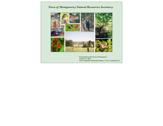
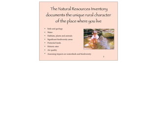
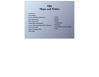
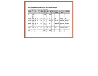
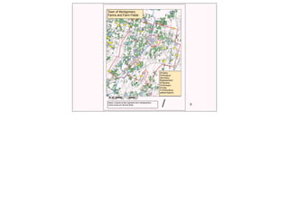
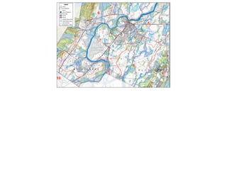
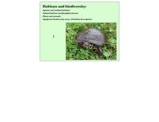
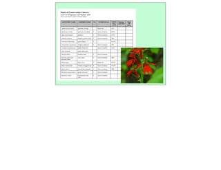
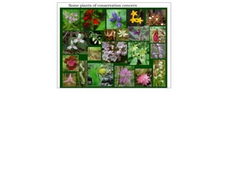
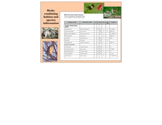
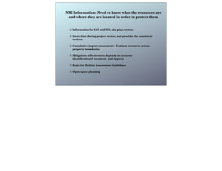
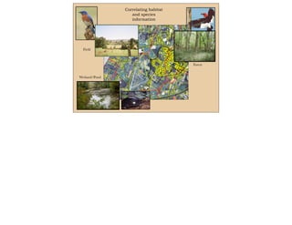
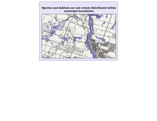
Town of Montgomery Natural Resources Inventory
Presentation to the Town of Montgomery
October 21, 2010
Karen Schneller-McDonald, Hickory Creek Consulting LLC
NYS General
Municipal Law: CAC’s,
NRIs, and Open Space
PlansText
3
5
2
7
4
6
8
1
10
11
917
12
12
20
/
Town of Montgomery
The County of Orange makes no warranty
whatsoever as to the accuracy or
completeness of any information depicted
on this map. Data depicted here may have
been developed in cooperation with other
County departments, as well as other Federal,
State and Local government agencies. The
County of Orange hereby disclaims liability
for any loss or damage resulting from the use
of the information and/or representations
contained herein.
Prepared June 16, 2008
by the Orange County Planning Department.
0 1 20.5
Miles
Legend
Roads
Drainage Basins - Details
Town Boundaries
Parcels
Text
Aerial Photography - 2004
Just as each parcel is a small
part of the Town, the NRI is
part of a larger effort to
identify and protect natural
resources
Biodiversity Assessment Training: Town of
Montgomery study area report and habitat map Southern Wallkill Biodiversity Plan
Biodiversity
Assessment Manual
for the Hudson River
Estuary Corridor
New York State
Comprehensive Wildlife
Conservation Strategy
Orange County Open Space Plan
New York Natural Heritage Program
New York State Open Space Plan
"The environment is not a competing interest to be balanced with other interests; rather, it
is the playing field, the very foundation, upon which all our interests compete." 
~ Dr. Michael Klemens, Founder, Metropolitan Conservation Alliance
Wallkill River
Corridor Study:
Town of Montgomery
The Natural Resources Inventory
documents the unique rural character
of the place where you live
• Soils and geology
• Water
• Habitats, plants and animals
• Significant biodiversity areas
• Protected lands
• Historic sites
• Air quality
• Assessing impacts on watersheds and biodiversity
3
NRI
Maps and Tables
• Aerial View
• Steep Slopes
• Farms and Prime/Statewide
Agricultural Soils
• Water Resources
• Public Wells and Aquifers
• Stream Biomonitoring (table and map)
• Protected Lands
• Historic Register Sites
• 1895 Maps
• Soils
• Plants
• Birds
• Amphibians
• Reptiles
• Dragonflies and Damselflies
• Fish
Soils and Geology
• Soil properties table sample
6
E
Town of Montgomery
Farms and Farm Fields
D=Dairy
P=Produce
DR=Dairy
Replacement
E=Equine
O=Orchard
H=Hay
F=Floriculture
yellow=equine
E
O
P
D
H
H
U
U
P
F
P
H
U
H
H
D
D
H BD
D
D
D
D
D
D
D
D
D D
D
D
D DR
DR
DR
Notes: Colored circles represent farm headquarters.
Green areas are farmed fields.
/
0 4,600 9,200 13,800 18,4002,300
Feet
Text
t
Habitats and biodiversity:
Aquatic and wetland habitats
Upland habitats and floodplain forests
Plants and animals
Significant biodiversity areas, 20 habitat descriptions
SCIENTIFIC NAME COMMON NAME NY NYNHPATLAS USFWS
WET-
LAND
Shawan-
gunk Kill
Wall-
kill
River
Agrimonia parviflora agrimony, swamp Watch list FAC * *
Agrimonia rostella agrimony, woodland T Active inventory FACU
Aplectrum hyemale puttyroot E Active inventory FACU
Arethusa bulbosa dragon's mouth orchid T Active inventory OBL
Arisaema dracontium green dragon V FACW *
Aristolochia serpentaria Virginia snakeroot E Active inventory UPL
Asclepias purpurascens purple milkweed Active inventory FACU
Aster vimineus small white aster * *
Atriplex dioica thickleaf orah E Active inventory
Bartonia paniculata
spp.paniculata
screw-stem E Active inventory OBL
Betula nigra birch, river V Watch list FACW *
Bidens bidentoides Delmarva beggar-ticks R Active inventory FACW
Bidens laevis smooth bur-marigold T Active inventory OBL
Boechera missouriensis green rock-cress T Active inventory
Boechera stricta Drummond’s rock
cress
E Active inventory
Plants of Conservation Concern
Towns of Montgomery and Wallkill: 2008
This is a working list, subject to periodic updates.
Sample plant list
Some plants of conservation concern
COMMON NAME SCIENTIFIC NAME US NY PIF SGCN DEV-
SEN
HABITAT
GREBES, WADING BIRDS,
DUCKS
American bittern Botaurus lentiginosus SC PIF X X OU, MSW
American black duck Anas rubripes PIF X X MSW, LW
Black-crowned night heron Nycticorax nycticorax PIF X TF, MSW, LW
Blue-winged teal Anas discors X MSW, OU
Least bittern Ixobrychus exilis T PIF X X MSW
Wood duck Aix sponsa PIF X
Pied billed grebe Podilymbus podiceps T PIF X X MSW, LC
DIURNAL RAPTORS
Cooper's hawk Accipiter cooperii SC PIF X X TF
Red-shouldered hawk Buteo lineatus SC PIF X X TF, MSW
Sharp-shinned hawk Accipiter striatus SC PIF X X TF
Northern goshawk Accipiter gentilis SC PIF X TF, AM
Northern harrier Circus cyaneus T X OU, MSW, LW
Birds of Conservation Concern
Towns of Montgomery and Wallkill: 2008
This is a preliminary list, subject to update as necessary.
Birds:
combining
habitat and
species
information
NRI Information: Need to know what the resources are
and where they are located in order to protect them
Information for EAF and EIS, site plan reviews
Saves time during project review, and provides for consistent
reviews
Cumulative impact assessment - Evaluate resources across
property boundaries
Mitigation: effectiveness depends on accurate
identificationof resources and impacts
Basis for Habitat Assessment Guidelines
Open space planning
Environmental
Assessment
Form Part 1
pre-and post-
construction
acreages: habitat
14
Environmental
Assessment
Form Part 2
identification of
impacts on species
and habitats
(upland, wetland,
aquatic)
Correlating habitat
and species
information
3
5
7
4
6
810
11
917
12
12
20
/
The County of Orange makes no warranty
whatsoever as to the accuracy or
completeness of any information depicted
on this map. Data depicted here may have
been developed in cooperation with other
County departments, as well as other Federal,
State and Local government agencies. The
County of Orange hereby disclaims liability
for any loss or damage resulting from the use
of the information and/or representations
contained herein.
pared June 16, 2008
County Planning Department.
1 2
Miles
Text
Forest
Field
Wetland/Pond
Species and habitats are not evenly distributed within
municipal boundaries
Inventory of
plants and
animals:
identification of
impacts on
biodiversity
Development-sensitive: Many species, high biodiversity
Habitat specialists
Specific habitat requirements
Complex life cycle requirements
Sensitive to development, degraded habitat
Development-associated: Few species, low biodiversity
Habitat generalists
Less-specific habitat requirements
Able to adapt to disturbed habitat and habitat edges
Associated with development: lawns and landscaping
Example of
biodiversity changes
Development-sensitive
Amphibians: 12 species
Reptiles: 12 species
Birds: 54 species
(example from Southern Wallkill Biodiversity Plan)
Development-associated
Amphibians: 5 species
Reptiles: 6 species
Birds: 9 species
(example from Southern Wallkill Biodiversity Plan)
Species of Conservation Concern
Absence indicates habitat loss or degradation
Presence is associated with higher biodiversity
Interconnections among species and populations
Specific habitat requirements
Montgomery NRI identifies:
Birds-- 75 species
Reptiles-- 10 species
Amphibians-- 16 species
! Nesting area! Streambank! Riparian buffer! Dispersal impediment
Roads! ! ! !
Impervious
surfaces! ! ! !
Grading/
construction! ! ! !
Nesting
sites
Streambank
condition
Size of
riparian
buffer
Corridors for
movement
Food
source
Adult
turtles
Hatchlings
Grading/
vegetation
removal
Impervious
surfaces
Roads
Construction
Post-
construction use
(pets,
pesticides)
Sample species impacts table:
wood turtle
A table similar to the simplified
example below can be used to
connect project activities with
impacts on a particular species or
group. This can facilitate the
development and evaluation of
effective mitigation measures.
Biodiversity is not about rushing to halt development because of the
presence of a threatened or endangered species: it is a broader
approach that includes the entire landscape
NRI is a Work in Progress:
Continue to add and update information as needed
• New studies, add information as it becomes available
(Biodiversity AssessmentTraining report and habitat
mapping)
• Municipal needs
• Additional text/ topics
• Additional maps and tables
23
Legacy
“ We have a moral commitment to leave for future generations a livable
environment even perhaps a better one than the one we inherited, certainly
not one that has been further depleted.”
--Amatai Etzioni, “Spirit of Community”
Karen Schneller-McDonald
Hickory Creek Consulting LLC
845 758-2369 *** katykill2@gmail.com *** HickoryCreekLLC.com

Natural Resources Inventory

  • 1.
    Town of MontgomeryNatural Resources Inventory Presentation to the Town of Montgomery October 21, 2010 Karen Schneller-McDonald, Hickory Creek Consulting LLC
  • 2.
    NYS General Municipal Law:CAC’s, NRIs, and Open Space PlansText 3 5 2 7 4 6 8 1 10 11 917 12 12 20 / Town of Montgomery The County of Orange makes no warranty whatsoever as to the accuracy or completeness of any information depicted on this map. Data depicted here may have been developed in cooperation with other County departments, as well as other Federal, State and Local government agencies. The County of Orange hereby disclaims liability for any loss or damage resulting from the use of the information and/or representations contained herein. Prepared June 16, 2008 by the Orange County Planning Department. 0 1 20.5 Miles Legend Roads Drainage Basins - Details Town Boundaries Parcels Text Aerial Photography - 2004 Just as each parcel is a small part of the Town, the NRI is part of a larger effort to identify and protect natural resources Biodiversity Assessment Training: Town of Montgomery study area report and habitat map Southern Wallkill Biodiversity Plan Biodiversity Assessment Manual for the Hudson River Estuary Corridor New York State Comprehensive Wildlife Conservation Strategy Orange County Open Space Plan New York Natural Heritage Program New York State Open Space Plan "The environment is not a competing interest to be balanced with other interests; rather, it is the playing field, the very foundation, upon which all our interests compete."  ~ Dr. Michael Klemens, Founder, Metropolitan Conservation Alliance Wallkill River Corridor Study: Town of Montgomery
  • 3.
    The Natural ResourcesInventory documents the unique rural character of the place where you live • Soils and geology • Water • Habitats, plants and animals • Significant biodiversity areas • Protected lands • Historic sites • Air quality • Assessing impacts on watersheds and biodiversity 3
  • 4.
    NRI Maps and Tables •Aerial View • Steep Slopes • Farms and Prime/Statewide Agricultural Soils • Water Resources • Public Wells and Aquifers • Stream Biomonitoring (table and map) • Protected Lands • Historic Register Sites • 1895 Maps • Soils • Plants • Birds • Amphibians • Reptiles • Dragonflies and Damselflies • Fish
  • 5.
    Soils and Geology •Soil properties table sample
  • 6.
    6 E Town of Montgomery Farmsand Farm Fields D=Dairy P=Produce DR=Dairy Replacement E=Equine O=Orchard H=Hay F=Floriculture yellow=equine E O P D H H U U P F P H U H H D D H BD D D D D D D D D D D D D D DR DR DR Notes: Colored circles represent farm headquarters. Green areas are farmed fields. / 0 4,600 9,200 13,800 18,4002,300 Feet
  • 7.
  • 9.
    t Habitats and biodiversity: Aquaticand wetland habitats Upland habitats and floodplain forests Plants and animals Significant biodiversity areas, 20 habitat descriptions
  • 10.
    SCIENTIFIC NAME COMMONNAME NY NYNHPATLAS USFWS WET- LAND Shawan- gunk Kill Wall- kill River Agrimonia parviflora agrimony, swamp Watch list FAC * * Agrimonia rostella agrimony, woodland T Active inventory FACU Aplectrum hyemale puttyroot E Active inventory FACU Arethusa bulbosa dragon's mouth orchid T Active inventory OBL Arisaema dracontium green dragon V FACW * Aristolochia serpentaria Virginia snakeroot E Active inventory UPL Asclepias purpurascens purple milkweed Active inventory FACU Aster vimineus small white aster * * Atriplex dioica thickleaf orah E Active inventory Bartonia paniculata spp.paniculata screw-stem E Active inventory OBL Betula nigra birch, river V Watch list FACW * Bidens bidentoides Delmarva beggar-ticks R Active inventory FACW Bidens laevis smooth bur-marigold T Active inventory OBL Boechera missouriensis green rock-cress T Active inventory Boechera stricta Drummond’s rock cress E Active inventory Plants of Conservation Concern Towns of Montgomery and Wallkill: 2008 This is a working list, subject to periodic updates.
  • 11.
    Sample plant list Someplants of conservation concern
  • 12.
    COMMON NAME SCIENTIFICNAME US NY PIF SGCN DEV- SEN HABITAT GREBES, WADING BIRDS, DUCKS American bittern Botaurus lentiginosus SC PIF X X OU, MSW American black duck Anas rubripes PIF X X MSW, LW Black-crowned night heron Nycticorax nycticorax PIF X TF, MSW, LW Blue-winged teal Anas discors X MSW, OU Least bittern Ixobrychus exilis T PIF X X MSW Wood duck Aix sponsa PIF X Pied billed grebe Podilymbus podiceps T PIF X X MSW, LC DIURNAL RAPTORS Cooper's hawk Accipiter cooperii SC PIF X X TF Red-shouldered hawk Buteo lineatus SC PIF X X TF, MSW Sharp-shinned hawk Accipiter striatus SC PIF X X TF Northern goshawk Accipiter gentilis SC PIF X TF, AM Northern harrier Circus cyaneus T X OU, MSW, LW Birds of Conservation Concern Towns of Montgomery and Wallkill: 2008 This is a preliminary list, subject to update as necessary. Birds: combining habitat and species information
  • 13.
    NRI Information: Needto know what the resources are and where they are located in order to protect them Information for EAF and EIS, site plan reviews Saves time during project review, and provides for consistent reviews Cumulative impact assessment - Evaluate resources across property boundaries Mitigation: effectiveness depends on accurate identificationof resources and impacts Basis for Habitat Assessment Guidelines Open space planning
  • 14.
    Environmental Assessment Form Part 1 pre-andpost- construction acreages: habitat 14
  • 15.
    Environmental Assessment Form Part 2 identificationof impacts on species and habitats (upland, wetland, aquatic)
  • 16.
    Correlating habitat and species information 3 5 7 4 6 810 11 917 12 12 20 / TheCounty of Orange makes no warranty whatsoever as to the accuracy or completeness of any information depicted on this map. Data depicted here may have been developed in cooperation with other County departments, as well as other Federal, State and Local government agencies. The County of Orange hereby disclaims liability for any loss or damage resulting from the use of the information and/or representations contained herein. pared June 16, 2008 County Planning Department. 1 2 Miles Text Forest Field Wetland/Pond
  • 17.
    Species and habitatsare not evenly distributed within municipal boundaries
  • 18.
    Inventory of plants and animals: identificationof impacts on biodiversity Development-sensitive: Many species, high biodiversity Habitat specialists Specific habitat requirements Complex life cycle requirements Sensitive to development, degraded habitat Development-associated: Few species, low biodiversity Habitat generalists Less-specific habitat requirements Able to adapt to disturbed habitat and habitat edges Associated with development: lawns and landscaping
  • 19.
    Example of biodiversity changes Development-sensitive Amphibians:12 species Reptiles: 12 species Birds: 54 species (example from Southern Wallkill Biodiversity Plan) Development-associated Amphibians: 5 species Reptiles: 6 species Birds: 9 species (example from Southern Wallkill Biodiversity Plan)
  • 20.
    Species of ConservationConcern Absence indicates habitat loss or degradation Presence is associated with higher biodiversity Interconnections among species and populations Specific habitat requirements Montgomery NRI identifies: Birds-- 75 species Reptiles-- 10 species Amphibians-- 16 species
  • 21.
    ! Nesting area!Streambank! Riparian buffer! Dispersal impediment Roads! ! ! ! Impervious surfaces! ! ! ! Grading/ construction! ! ! ! Nesting sites Streambank condition Size of riparian buffer Corridors for movement Food source Adult turtles Hatchlings Grading/ vegetation removal Impervious surfaces Roads Construction Post- construction use (pets, pesticides) Sample species impacts table: wood turtle A table similar to the simplified example below can be used to connect project activities with impacts on a particular species or group. This can facilitate the development and evaluation of effective mitigation measures.
  • 22.
    Biodiversity is notabout rushing to halt development because of the presence of a threatened or endangered species: it is a broader approach that includes the entire landscape
  • 23.
    NRI is aWork in Progress: Continue to add and update information as needed • New studies, add information as it becomes available (Biodiversity AssessmentTraining report and habitat mapping) • Municipal needs • Additional text/ topics • Additional maps and tables 23
  • 24.
    Legacy “ We havea moral commitment to leave for future generations a livable environment even perhaps a better one than the one we inherited, certainly not one that has been further depleted.” --Amatai Etzioni, “Spirit of Community”
  • 25.
    Karen Schneller-McDonald Hickory CreekConsulting LLC 845 758-2369 *** katykill2@gmail.com *** HickoryCreekLLC.com