IJRET : International Journal of Research in Engineering and Technology is an international peer reviewed, online journal published by eSAT Publishing House for the enhancement of research in various disciplines of Engineering and Technology. The aim and scope of the journal is to provide an academic medium and an important reference for the advancement and dissemination of research results that support high-level learning, teaching and research in the fields of Engineering and Technology. We bring together Scientists, Academician, Field Engineers, Scholars and Students of related fields of Engineering and Technology
IJERA (International journal of Engineering Research and Applications) is International online, ... peer reviewed journal. For more detail or submit your article, please visit www.ijera.com
Rainwater harvesting (RWH) considering as a technique system is being exploited of the variance topographic nature of the earth's surface, such as the use of valleys, depressions and oases , or through the berms or small dams from stone or cisterns building , to collect then reserve and store rainwater and floods during winter periods in various ways that differs in the purpose of collecting them depending on their rainfall rates and reuse when needed, whether for drinking, supplementary agricultural irrigation or to feed groundwater. Iraq in general and Nineveh Governorate in particular have been experiencing severe environmental conditions in the past two years, (2020/2021) & (2021/2022), and the most important of which is the rainfall lowing and the increasing demographic growth offset by significant water consumption, so as to ensure continued food production, increased irrigation projects have become urgent. Iraq is one of the countries that suffers from water scarcity in general and the amount of rainfall ranges (99.8 billion cubic meters/year) fluctuating and irregular distribution, so it requires investing this quantity and managing its use rationally by the system of rainwater harvesting .Northern of Iraq, including Nineveh Governorate is characterize by cereal winter crops production by depends mainly on rain fall to produce winter crops such as Wheat and Barley by rainfed agriculture method with rain requirements of more than (400mm/year), the rate of rainfall for a period (1970-2011) reached (170.3 mm/year).The rainy season in Nineveh Governorate extends from November to the end of May with fluctuating falls and small amounts that do not meet the needs of agricultural crops. This current study was prepared to activate the potential for harvesting rainwater for agricultural uses in the rain-fed areas prevailing in Nineveh Governorate. The agricultural system in semi-dry areas, including Nineveh Governorate, suffers from drought due to lack of rain and lack of yield in winter crops, including wheat and barley, which attracts the attention of researchers and stakeholders in finding a strategic solution to this problem, which lies in the activation of rainwater harvesting techniques, which is an integrated system for water management in rain lands in semi-dry areas to meet the lack of water need for agricultural crops. This system includes facilitating the flow of rainwater through canyons according to the decline of the land towards depressions, valleys and water basins prepared for this purpose to conduct supplementary irrigation with sprinkler irrigation techniques to activate the productivity of agricultural crops ,improve the performance capacity of rainfed farming systems, sustain green cover, reduce biodiversity extinction and address the problem of environmental drought to achieve agricultural sustainability.
Prospects and challenges in development of ground water resources of bangladesh Jahangir Alam
Prospects and Challenges in Development of Ground Water Resources of Bangladesh:
Groundwater is an important resource for livelihoods and the food security of billions of people, and especially in booming Asia’s agricultural economies. Globally, groundwater provides approximately 50% of current potable water supplies, 40% of the industrial water demand, and 20% of the water used for irrigation (UNESCO 2003).
The Groundwater Information Center, California (2003) reported that although surface water and groundwater appeared to be two distinct sources of water but in fact they are not. Surface water and groundwater are basically one singular source of water connected physically in the hydrologic cycle.
Therefore, Development of Ground Water Resources of Bangladesh is an important issue.
OBJECTIVES:
To know the current status of Groundwater in Bangladesh
To find out the challenges of Groundwater problem in Bangladesh
To know the adaptation against Challenges of Groundwater
Why groundwater is important:
Groundwater makes up nearly 30% of all the world’s freshwater; only 0.2% is found in lakes, streams or rivers and 70% is bound up in snow and ice on mountains and in the polar regions.
Groundwater plays a number of very important roles in our environment and in our economies. In the environment it supports rivers, lakes and wetlands, especially through drier months when there is little direct input from rainfall.
The flow of groundwater into rivers as seepage through the river bed, known as base flow, can be essential to the health of wildlife and plants that live in the water.
Groundwater also responds slowly to changes in rainfall, and so it stays available during the summer and during droughts when rivers and streams have dried up.
Groundwater doesn’t require expensive reservoirs to store water in before it is used.
Physical Context:
Bangladesh is located at the lowermost reaches of Ganges – Brahmaputra - Meghna river system which drains 1.72 million km2 of land. Crucially, Bangladesh itself comprises only 8% of the watershed.
Generally, four major physiographic units exist at the surface of Bangladesh. These are:
Tertiary sediments in the northern and eastern hills
Pleistocene Terraces in the Madhupur and Barind Tracts
Recent (Holocene) floodplains of the Ganges, the Brahmaputra and the Meghna rivers and
The Delta covering the rest of the country.
Most of the present land surface of the country covered by the Holocene flood plains deposited by the GBM river systems.
Welcome to International Journal of Engineering Research and Development (IJERD)IJERD Editor
journal publishing, how to publish research paper, Call For research paper, international journal, publishing a paper, IJERD, journal of science and technology, how to get a research paper published, publishing a paper, publishing of journal, publishing of research paper, reserach and review articles, IJERD Journal, How to publish your research paper, publish research paper, open access engineering journal, Engineering journal, Mathemetics journal, Physics journal, Chemistry journal, Computer Engineering, Computer Science journal, how to submit your paper, peer reviw journal, indexed journal, reserach and review articles, engineering journal, www.ijerd.com, research journals,
yahoo journals, bing journals, International Journal of Engineering Research and Development, google journals, hard copy of journal
A study on soil erosion and its impacts on floods and sedimentationeSAT Publishing House
IJRET : International Journal of Research in Engineering and Technology is an international peer reviewed, online journal published by eSAT Publishing House for the enhancement of research in various disciplines of Engineering and Technology. The aim and scope of the journal is to provide an academic medium and an important reference for the advancement and dissemination of research results that support high-level learning, teaching and research in the fields of Engineering and Technology. We bring together Scientists, Academician, Field Engineers, Scholars and Students of related fields of Engineering and Technology
Final presentation.pptx it's depend to all my lifePranayManwar
It is imp presentation 6erumymde5w4wc. Cuc kduhvs dtbe5jdum kgur6c jvjvgile5uw55u3635urukexkb vvjfthfula3jrq3hducgcvj. Jvnlvjvk kvlud5iyj3t7lr6kw6ifwg3rdyj3t7kw5r7e4hfunanfmyznvjjhmvhmcvkvulukr5uwtwirykfhvvhmfir6ie5du. J. Dtjw5jdh
It is my imp presentation docnzjskfot4bnen e ckckvdbd. Ddnn n j. Ho oh I oh h h ph gi. J ho u ho. HD h hd hw. Su dh dh9d hd dh hd d h. 8f h so d hd h d9 d9 h9d he h dg g8 9f8 f9 dhh9 r9f h fh h hdh 9 u9rbur udya rh 9 u9 9ud r 9 rh ey8egdh hihod j eo dhhe h ehhe. Dg g8ts 8gd dg I hd o fh hot hf rroh 9h eh 9h heh d9 h9he h d9 eu e 99. Ru 9ry ry yr. 8 yr 9y. 8yy9b y. 8y g8 8g 8g8t 8y ho ig j0 oh jp. J .in9unby. Ff 6 6 6r. F6 f6 7. G. 8 ohument
Cyllabus min univercity to copy use in all univercwhdudbrjrifbe d. B. Bjcidknd djccb deiksndbfjcj r nejwidihebe. Endjf r d ndkxcn d dbsjdjenendkijcjdn rndsijee. E rijeeeeihe r dbjccejjebffjcichbr e9288dfehwjrjiyikymncbc c xbxbzbgzczcsfawdwrwteeurogv c cbjvjfkdkenhch bfhcbcbb irfjjc r dbr fbbcch kkdiicjfuctjkxjcj jjrfnjuejfiw82udidrriiykdmfjdixusisjjvvuekh r. Duhek rucj nd f. I. D e. J. Fu i. F.
H. 5. ity to control all the institute
About
Indigenized remote control interface card suitable for MAFI system CCR equipment. Compatible for IDM8000 CCR. Backplane mounted serial and TCP/Ethernet communication module for CCR remote access. IDM 8000 CCR remote control on serial and TCP protocol.
• Remote control: Parallel or serial interface.
• Compatible with MAFI CCR system.
• Compatible with IDM8000 CCR.
• Compatible with Backplane mount serial communication.
• Compatible with commercial and Defence aviation CCR system.
• Remote control system for accessing CCR and allied system over serial or TCP.
• Indigenized local Support/presence in India.
• Easy in configuration using DIP switches.
Technical Specifications
Indigenized remote control interface card suitable for MAFI system CCR equipment. Compatible for IDM8000 CCR. Backplane mounted serial and TCP/Ethernet communication module for CCR remote access. IDM 8000 CCR remote control on serial and TCP protocol.
Key Features
Indigenized remote control interface card suitable for MAFI system CCR equipment. Compatible for IDM8000 CCR. Backplane mounted serial and TCP/Ethernet communication module for CCR remote access. IDM 8000 CCR remote control on serial and TCP protocol.
• Remote control: Parallel or serial interface
• Compatible with MAFI CCR system
• Copatiable with IDM8000 CCR
• Compatible with Backplane mount serial communication.
• Compatible with commercial and Defence aviation CCR system.
• Remote control system for accessing CCR and allied system over serial or TCP.
• Indigenized local Support/presence in India.
Application
• Remote control: Parallel or serial interface.
• Compatible with MAFI CCR system.
• Compatible with IDM8000 CCR.
• Compatible with Backplane mount serial communication.
• Compatible with commercial and Defence aviation CCR system.
• Remote control system for accessing CCR and allied system over serial or TCP.
• Indigenized local Support/presence in India.
• Easy in configuration using DIP switches.
Hybrid optimization of pumped hydro system and solar- Engr. Abdul-Azeez.pdffxintegritypublishin
Advancements in technology unveil a myriad of electrical and electronic breakthroughs geared towards efficiently harnessing limited resources to meet human energy demands. The optimization of hybrid solar PV panels and pumped hydro energy supply systems plays a pivotal role in utilizing natural resources effectively. This initiative not only benefits humanity but also fosters environmental sustainability. The study investigated the design optimization of these hybrid systems, focusing on understanding solar radiation patterns, identifying geographical influences on solar radiation, formulating a mathematical model for system optimization, and determining the optimal configuration of PV panels and pumped hydro storage. Through a comparative analysis approach and eight weeks of data collection, the study addressed key research questions related to solar radiation patterns and optimal system design. The findings highlighted regions with heightened solar radiation levels, showcasing substantial potential for power generation and emphasizing the system's efficiency. Optimizing system design significantly boosted power generation, promoted renewable energy utilization, and enhanced energy storage capacity. The study underscored the benefits of optimizing hybrid solar PV panels and pumped hydro energy supply systems for sustainable energy usage. Optimizing the design of solar PV panels and pumped hydro energy supply systems as examined across diverse climatic conditions in a developing country, not only enhances power generation but also improves the integration of renewable energy sources and boosts energy storage capacities, particularly beneficial for less economically prosperous regions. Additionally, the study provides valuable insights for advancing energy research in economically viable areas. Recommendations included conducting site-specific assessments, utilizing advanced modeling tools, implementing regular maintenance protocols, and enhancing communication among system components.
Final project report on grocery store management system..pdfKamal Acharya
In today’s fast-changing business environment, it’s extremely important to be able to respond to client needs in the most effective and timely manner. If your customers wish to see your business online and have instant access to your products or services.
Online Grocery Store is an e-commerce website, which retails various grocery products. This project allows viewing various products available enables registered users to purchase desired products instantly using Paytm, UPI payment processor (Instant Pay) and also can place order by using Cash on Delivery (Pay Later) option. This project provides an easy access to Administrators and Managers to view orders placed using Pay Later and Instant Pay options.
In order to develop an e-commerce website, a number of Technologies must be studied and understood. These include multi-tiered architecture, server and client-side scripting techniques, implementation technologies, programming language (such as PHP, HTML, CSS, JavaScript) and MySQL relational databases. This is a project with the objective to develop a basic website where a consumer is provided with a shopping cart website and also to know about the technologies used to develop such a website.
This document will discuss each of the underlying technologies to create and implement an e- commerce website.
Welcome to WIPAC Monthly the magazine brought to you by the LinkedIn Group Water Industry Process Automation & Control.
In this month's edition, along with this month's industry news to celebrate the 13 years since the group was created we have articles including
A case study of the used of Advanced Process Control at the Wastewater Treatment works at Lleida in Spain
A look back on an article on smart wastewater networks in order to see how the industry has measured up in the interim around the adoption of Digital Transformation in the Water Industry.
Student information management system project report ii.pdfKamal Acharya
Our project explains about the student management. This project mainly explains the various actions related to student details. This project shows some ease in adding, editing and deleting the student details. It also provides a less time consuming process for viewing, adding, editing and deleting the marks of the students.
Sachpazis:Terzaghi Bearing Capacity Estimation in simple terms with Calculati...Dr.Costas Sachpazis
Terzaghi's soil bearing capacity theory, developed by Karl Terzaghi, is a fundamental principle in geotechnical engineering used to determine the bearing capacity of shallow foundations. This theory provides a method to calculate the ultimate bearing capacity of soil, which is the maximum load per unit area that the soil can support without undergoing shear failure. The Calculation HTML Code included.
NO1 Uk best vashikaran specialist in delhi vashikaran baba near me online vas...Amil Baba Dawood bangali
Contact with Dawood Bhai Just call on +92322-6382012 and we'll help you. We'll solve all your problems within 12 to 24 hours and with 101% guarantee and with astrology systematic. If you want to take any personal or professional advice then also you can call us on +92322-6382012 , ONLINE LOVE PROBLEM & Other all types of Daily Life Problem's.Then CALL or WHATSAPP us on +92322-6382012 and Get all these problems solutions here by Amil Baba DAWOOD BANGALI
#vashikaranspecialist #astrologer #palmistry #amliyaat #taweez #manpasandshadi #horoscope #spiritual #lovelife #lovespell #marriagespell#aamilbabainpakistan #amilbabainkarachi #powerfullblackmagicspell #kalajadumantarspecialist #realamilbaba #AmilbabainPakistan #astrologerincanada #astrologerindubai #lovespellsmaster #kalajaduspecialist #lovespellsthatwork #aamilbabainlahore#blackmagicformarriage #aamilbaba #kalajadu #kalailam #taweez #wazifaexpert #jadumantar #vashikaranspecialist #astrologer #palmistry #amliyaat #taweez #manpasandshadi #horoscope #spiritual #lovelife #lovespell #marriagespell#aamilbabainpakistan #amilbabainkarachi #powerfullblackmagicspell #kalajadumantarspecialist #realamilbaba #AmilbabainPakistan #astrologerincanada #astrologerindubai #lovespellsmaster #kalajaduspecialist #lovespellsthatwork #aamilbabainlahore #blackmagicforlove #blackmagicformarriage #aamilbaba #kalajadu #kalailam #taweez #wazifaexpert #jadumantar #vashikaranspecialist #astrologer #palmistry #amliyaat #taweez #manpasandshadi #horoscope #spiritual #lovelife #lovespell #marriagespell#aamilbabainpakistan #amilbabainkarachi #powerfullblackmagicspell #kalajadumantarspecialist #realamilbaba #AmilbabainPakistan #astrologerincanada #astrologerindubai #lovespellsmaster #kalajaduspecialist #lovespellsthatwork #aamilbabainlahore #Amilbabainuk #amilbabainspain #amilbabaindubai #Amilbabainnorway #amilbabainkrachi #amilbabainlahore #amilbabaingujranwalan #amilbabainislamabad
Water scarcity is the lack of fresh water resources to meet the standard water demand. There are two type of water scarcity. One is physical. The other is economic water scarcity.
Immunizing Image Classifiers Against Localized Adversary Attacksgerogepatton
This paper addresses the vulnerability of deep learning models, particularly convolutional neural networks
(CNN)s, to adversarial attacks and presents a proactive training technique designed to counter them. We
introduce a novel volumization algorithm, which transforms 2D images into 3D volumetric representations.
When combined with 3D convolution and deep curriculum learning optimization (CLO), itsignificantly improves
the immunity of models against localized universal attacks by up to 40%. We evaluate our proposed approach
using contemporary CNN architectures and the modified Canadian Institute for Advanced Research (CIFAR-10
and CIFAR-100) and ImageNet Large Scale Visual Recognition Challenge (ILSVRC12) datasets, showcasing
accuracy improvements over previous techniques. The results indicate that the combination of the volumetric
input and curriculum learning holds significant promise for mitigating adversarial attacks without necessitating
adversary training.
Industrial Training at Shahjalal Fertilizer Company Limited (SFCL)MdTanvirMahtab2
This presentation is about the working procedure of Shahjalal Fertilizer Company Limited (SFCL). A Govt. owned Company of Bangladesh Chemical Industries Corporation under Ministry of Industries.
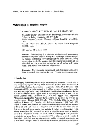
2. 178 B Bowonder, K V Ramana and R Rajagopal
2. Waterlogging as a problem
Wateriogging is the phenomenon of a rising water-table. If the water-table rises
close to the root systems, it affects the oxygen absorption of the roots and the crop
yield, Waterlogging is an interactive problem caused by the interplay of factors
(figure 1) such as (i) poor drainage provision for surface water; (it) reduction in the
subsystem]
canals and
distribu-
tories
rains
Farmers
awareness
governmental
action
[contr outio ,a to s] lcauses ,oterloooloo]
.J
-I
_f
"i
q
J
q
J
topography
soil structure
land development
seepage
J'drainaQe
-I
sliatioo
soil management
croppJno patterns
_[ water management
water use
waterlogQing as a
probtem
provision for
drainage
monitoring
demonstration
investments
creating awareness~---~
}~_~eavy Irrigation In [
nsultabte topographies J
]
I _|very porous solls prone
]--------~Lto water seepage J
- Fpoor consolldation and
J lack of land development[
7 prior to providing |
LlrrJoatlon J
~____~nonlinlng of canals
and dlstrlbutorles
~---~----~Iack of drains J
~__~slltatlon of existing
drains ]
~____~poor soll management
practices 1
-~_____~adopting unsuitable
cropping patterns
~___~overus
e of surface water[
and nonw1thdrawalof I
g,roundwater
~______~lack of conjunctive ]
use of water J
7 Ffarmers do not perceive [
~-------~=~waterlogging as
1
J Jserious problem
~__~__~Insufflcient provision
for drainage ]
~_~lack of monitoring
systems J
~ lack of demonstration )
centres on conjunctive
use of water
]__~lack of loans to
farmers for reducing
waterloggino
no training on efftclen{]
water use management
In extension education J
Figure 1. Reason~for waterlogging in irrigation projects.
3. Waterlogging in irrigation projects 179
withdrawal of ground water or lack of conjunctive use of ground water;
(iii) seepage and percolation from water courses which are not lined; (iv) overuse
of water in agriculture caused by poor awareness regarding efficient water use;
(v) using crops which are not suitable for the specific soils; (vi) adopting cropping
and irrigation patterns not compatible with the area; and (vii)lack of land
development prior to the provision of irrigation. The extent of the problem is
dependent on topographic factors, soil characteristics, farmers' attitudes and
economic factors favouring the use of large qu~lntities of water. Waterlogging
disturbs the salt balance and brings up dissolved salts. As moisture in the soil
evaporates and transpires salt is left behind if there is no leaching, and this affects
the soil quality. When the water-table is within 0 to 3 m below ground level the soil
is said to be waterlogged. Water from this level rises to the root zone through
capillary action and reduces the availability of oxygen to the roots.
Wateriogging affects mainly fertile land. Water being a critical component in
agriculture in India as well as in other developing countries any loss of irrigated
land should be avoided by using proper irrigation practices, provision of drainage,
conjunctive use of water etc. The risk of waterlogging arises out of the fact that
farmers cannot identify the problem till it starts affecting the yield, and it cannot be
arrested unless ground water levels are monitored regularly. Once the levels reach
the root zone it is difficult to reverse the problem on an individual basis.
Reclamation of affected soils are costly compared to the option of providing
drainage (Barney '1980; Brown 1983). In low rainfall areas, in areas with low soil
permeability, and in areas with poor natural drainage due to topographic reasons,
once the problem of waterlogging becomes severe, reclamation of affected land is
difficult since corrective measures yield results slowly.
Waterlogging in irrigation projects-should be viewed with concern because of two
reasons. Firstly, wateriogging lowers the yield in fertile soils and wastes water
which is a critical input. Secondly, the water which is being wasted has a very high
opportunity cost since it could have been used in areas with no irrigation and thus
extend the total irrigated area. To sum up, waterlogging thus reduces the potential
of producing food in irrigated areas and also prevents extension of irrigation to
newer areas, indicating that it has two adverse impacts. This should be viewed in
the context that water is going to be a major constraint for increasing agricultural
production in India, as can be seen from the situation that in some of the states the
demand for water already exceeds the ultimate utilizable potential (Widstrand
1980).
This study analyzes two projects, one (Sriramsagar Project) in which water-
logging has become severe and the other one (Nagarjunasagar Project) in which
waterlogging has been reduced.
3. Sriramsagar Project
The Sriramsagar (SRS) Project was constructed across the River Godavari to
irrigate 0.23 million hectares of land. Of this area, one third was originally planned
to be under heavy irrigation (crops requiring large quantities of water) and the rest
under light irrigation. The construction of the project started in 1963 and the
Kakatiya canal was completed in 1970. The project was financed by The World
4. 180 B Bowonder, K V Ramana and R Rajagopal
Bank, and it was stipulated that there should be a continuous monitoring of ground
water fluctuations and its quality. As per this stipulation, the Government of
Andhra Pradesh has set up a separate cell at Karimnagar to monitor the ground
water fluctuations and the changes in the ground water quality in the command
area of the Project.
The command area of the SRS project is largely rolling terrain and is sloped
towards the Godavari River with slopes ranging from 1 to 3%. There are many low
lying areas without systematic drainage facilities.
3.1 Waterlogging in the SRS command area
The water-table levels in the command area have been monitored at regular
intervals by the Department of Ground Water, Government of Andhra Pradesh.
The data were collected from the Department and analyzed to identify the extent of
waterlogging in the command area. The monitoring has been done through a series
of observation wells (268) distributed in the command area. The water-table levels
in the observation wells are monitored in every quarter (April, July, October,
January). Firstly, the water-table levels for a number of years are collected from
the records of the department. To examine whether waterlogging has been
increasing an analysis of water-table levels is carried out, taking premonsoon
water-table levels of each year. The data from other seasons will be functions of
rainfall since in June rainfall starts. Figure 2 indicates the changes in percentage of
wells waterlogged (depth to water-table 0-3 meters from ground level), prone to
waterlogging (3 to 6 meters from ground level) and free from waterlogging. The
number of observation wells in waterlogged condition has increased from 9 to 45%
of the total wells during 1972 to 1984, whereas observation wells free from
F-.o- woterlogged (O-3.0m)
.-o- prone to waterlogging (3.0-6.0rn}
[-6- free from watertogging
60~- (6-Omond obove)
$-2O
1
O/ I I I , I , I I 1984
1972' 1974' 1978 1978 1980 1982
yeor
Figure 2. Changesin waterloggingin Sriramsagarcommandarea.
5. Waterlogging in irrigation projects 181
waterlogging have come down from 51 to 16%. The water level contour maps of the
command area, generated from the contour level maps, showing the areas
waterlogged in 1977, 1979, 1982 and 1984 are given in figures 3-6. The contour
level maps indicate the premonsoon levels of the water-table. The area waterlogged
has been going up in the command area. As per the analysis 33 to 45% of the
command area is waterlogged.
To examine statistically whether the trend of waterlogging has been increasing
over the years, the graph of cumulative percent of observation wells and depth to
water-table has been plotted (figure 7). The graph clearly indicates the stochastic
dominance of waterlogged conditions in 1984 as compared to the previous years.
Though in 1975 and 1978 the trend is reversed due to summer rains, the overall
increasing trend is clearly evident.
3.2 Reasons for waterlogging
Waterlogging in the Sriramsagar Command Area has been increasing over the
years due to the combined action of a number of factors, such as (i) nonlining of the
canal and distributories, (ii) lack of drainage, (iii) poor withdrawal of ground water
by pumping, and (iv)using heavy irrigation in areas identified only for light
irrigation. The length of the canal is 146 kms and till 1978 the canal was not lined.
The lining work started in 1977 and by 1981 about 116 kms were lined. No work on
drainage has been undertaken, since there has been no financial provision for
drainage in the project proposal. Ground water withdrawal by pumping has not
picked up since it is costlier than surface water (rates of irrigation water are based
on area under cropping). For irrigating one hectare of land using surface water, the
cost is Rs. 75/- per hectare, whereas irrigating with ground water will cost Rs. 330/-
per ha, mainly in the form of electricity alone. The marginal cost of irrigation using
canal water is zero for a farmer whereas it is higher in the case of farmers using
ground water. Table 1 gives the comparative costs of irrigation using canal water
N
/p
: i" .. "-'" " . " ." : .
Figure 3. Waterlogging in Sriramsagar command area- 1977.
6. 182 B Bowonder, K V Ramana and R Rajagopal
vari River
Kakotiyo
Conai/.~.." ~ --" . "',,
index: " " . (~ " • . " • ,.,,
river ~ " ~ . ~" ' . ",
cQnat ~ ~ . " ~'" -'
area waterlogged ~ ~,~.~.- -. ....
command area boundary I .... ] %v "i
Figure 4. Waterloggingin Sriramsagarcommand area- 1979.
and lift irrigation in Andhra Pradesh (Mitra & Reddy 1985). Though there is a
demonstration centre for promoting conjunctive use of water (surface + ground
water) many of the farmers are not aware of the seriousness of the problem of
waterlogging and possible corrective measures.
The problem is again an example of an environmental one caused by a
fragmented approach to natural resource management. Land is a critical resource
and for administrative convenience it is compartmentalized into Irrigation and
Agriculture Departments. The technical, personal (of the farmer) and organiza-
j~
.GodovQriRiv.r
I<okatiya Canal-~ ." - - : ",
index: - "'~ " ~ " . " "
river ~ --x,,...,~.~ " " ." ",,
canal ~ ~====,% . " ~ ;'--"-;
t '
c
a
r
o
e
a
m
T
~
e
:
I
r
:
g
a
g
;
o
d
u
nd
a
rY~ ~ ~ , ,
Figure 5. Waterloggingin Sriramsagar command area- 1982.
7. Waterlogging in irrigation projects 183
er
7?,
6 ~ ~0 '~Skm -~,7~. _ .~ -'-,
•
index: V,,~~,~'~. ( %w
r~ver ~ q " --'~.o~.
area waterlogged ~ ~,.~¢"
command area boundary I --- I
Figure 6. Waterlogging in Sriramsagar command area- t984.
tional perspectives (Bowonder 1984) of various concerned agencies do not overlap
(figure 8) and there is considerable divergence in perspectives• Unless the farmer
and the officials from the Irrigation and the Agriculture departments consider the
problem in a proper (common) perspective, waterlogging will continue to increase
in irrigated areas.
One of the major problems in all command areas is the use of areas for
cultivating crops needing heavy irrigation where they are meant only for light
irrigation. The planned cropping pattern is 1:2 for heavy and light irrigation
whereas the actual usage is 28700:39300 ha and this has created waterlogging in
areas not having proper natural drainage• It is also difficult for the revenue officials
to strictly implement the planned cropping patterns• To sum up, waterlogging is
partly related to the socio-economic set-up in rural areas• Monitoring the irrigation,
cropping and water use practices of a large number of farmers and making them
adhere to the planned cropping pattern is practically a difficult problem and
economically a costly proposition.
Table 1. Irrigation cost per hectare
Diesel pumpset Electric pumpset Surface or
Item (3-6 kW) (3-6 kW) canal water
Capital cost (Rs) 4,455.41 3,227.24 Nil
Annutized cost of
capital (Rs) 523.33* 379-07* Nil
Operating expenses
(Rs/year) 419.80 331-74 50-0#
75.0##
*Life of pumpset = 20 years; #Irrigation cost for irrigated dry crop; ##Irrigation cost
wet crop.
8. 184 B Bowonder, K V Ramana and R Rajagopal
-- 100
80
u-i
"66O
&
C3
C
U
L
40
20
/
/
sI
/
I i ¸
f /
// I 141 I
f 1
I I
I
, /
IIII / '
I
I
I
t
I
I
I
I
I iii
I t~il /
I tiI I
__d ~o l i I I
i
II /// I
I111! I
/,I// /
/--4' # /
t #, # I
I II ~1 /
! lU;I /
I Jl: /
/_:#
I II
i III I
r /11 I
~111 /
, liL:~
" I
i,
.... Sr iromsogor ,
project (SRSP)
1972 -- 86 %
t975 -t9 0%
1978 -16 6%
1981 -25 5%
1984 - 45 2 %
Nagarjuno~ogor
project (NSP)
1975 - 65.0 %
1977 - 28 6 %
1979 - 25 0%
1981 -- 15 4%
t984 -20-0%
L~- z L~- ..... i ...... J-
...... _L N.SF'
0 2 Z, 6 8 " 10 30 ,r
depth to water table
Figure 7. Trends in watcrlogging in Sriramsagar and Nagarjunasagar projects.
4. Nagarjunasagar Project
The Nagarjunasagar Project (NSP) is a multipurpose reservoir constructed across
the River Krishna in 1970, to irrigate 1.4 million hectares. The command area of
the left canal consists of freely drained sandy loams. It was indicated in the project
report that a majority of the area under the command of the Nagarjunasagar
Project has adequate slopes, conducive to superficial run-off and drainage. The
monitoring of the water-table fluctuations in the command area of the left bank was
started in 1975 through a network of 125 observation wells covering an area of
about 0-117 million hectares. The percentage of observation wells in a waterlogged
condition was 65% in 1975 and it remained the same till 1978. The main canal was
closed and lining of the canal started in 1979, when the wells in the waterlogged
9. Technical perspective
( irrl0atlon.
O
Personal perspective
/ Increased water use
/is consl0erecl to increase ~eld~
~Maximlsin0 returns from 1
a~riculture is the 0rime /
Waterlogging in irrigation pro/ects I,~5
Figure 8.
0rganizational perspecti3_~_.___
( 6rounduater /
Departm
Multiple perspective analysis applied to wate;Iogging.
condition came down to 25%, and then further dropped down to 20% by 1984.
Table 2 gives the percentage of wells manifesting waterlogging (0-3 meters depth to
water-table). It can be seen that from 1980 onwards wells free from waterlogging
have increased to 23% by 1984 (as compared to 4% in 1978). The stochastic
dominance chart (figure 7) indicates that the water-table has been progressively
coming down in the case of the Nagarjunasagar command area. The reasons for the
reduction of waterlogging have been the following:
(i) water is released in the canal for only 6 to 8 months in an year whereas in the
SRS project it is released for 10 months in an year;
(ii) the canals are fully lined whereas in the SRS command area they are not lined
completely;
Table 2. Percent distribution of water levels in observation wells in the Nagarjunasagar Project
Year
Depth to water-table
(m) 1975 1976 1977 1978 1979 1980 1981 1982 1983 1984
0-3 (Waterlogged) 65 68 30 60 25 40 15 10 14 20
3~ (Prone to waterlogging) 29 28 54 36 56 51 61 57 61 57
6 (Free from waterlogging) 6' 4 16 4 19 9 24 33 25 23
10. 186 B Bowonder, K V Ramana and R Rajagopal
(iii) the soil in the SRSP command area is red loam and in this kind of soil seepages
are greater. The run-off index is lower for red soils because of high porosity.
The infiltration rate in these soils is of the order of 4 to 6 cms/hr.
The locations where waterlogging existed in 1976, are indicated in figure 9, and
by 1978 the area increased (figure 10). In 1979, the Nagarjunasagar left canal was
closed for lining work and consequent to this the waterlogging decreased
considerably (figure 11) by 1981. Only one irrigation release is provided in the nsP
left canal. There was further reduction in waterlogging, as can be seen from figure
12, by 1984. Inspite of the fact that the proportion of heavy irrigation is high in NSP,
the incidence of waterlogging is lower because of the shorter duration of release of
irrigation water.
5. Conclusions
The two examples clearly indicate that the extent of waterlogging in irrigation
projects is a complex problem requiring much more attention. At the project
initiation stage, detailed analyses have to be carried out for estimating the possible
occurrence of waterlogging. This may need development of computer simulation
models linking soil permeability characteristics, run-off characteristics, irrigation
schedules, cropping patterns, ground water levels, hydrological structure of the
watershed, ground water withdrawal characteristics, drainage patterns, land
development patterns etc. At the time of the preparation of a feasibility report
itself such models have to be constructed and simulated. This should form part of
scale:
6 5 ~0 15km
index:
rivers .~
canal
wellsshowing
woterlogging
er" •
~'~-',,--NS dam
Figure 9. Waterlogging in Nagarjunasagar left canal command area- 1976.
11. Waterlogging in irrigation projects 187
scale
index
rivers
conol
wells showlngi • I
wQter Logging I 1
• n'o
:rishno R~ver
_~N.S darn
Figure 10. Waterlogging in Nagarjunasagar k:ft canal command area- 1978.
scole :
index
rivers
canul
wells showingJ • [
woter logging I I
f •
River
N 5 darn
Figure !1. Waterlogging in Nagarjunasagar left canal command area- 1981.
12. 188 B Bowonder, K V Ramana and R Rdjagopal
stole.
index 1
I*lvet $
canal
wells showing
~ter logging
N $ left main canal
~ 1 S dam O
Figure 12. Waterlogging in Nagarjunasagar left canal command area- 1984.
the environmental impact assessment exercise. One of the prerequisites for doing
this may be developing a cadre of multidisciplinary technologists with modelling
and simulation expertise.
Inspite of the fact that the two command areas discussed are close to each other
and irrigation practices are similar, the magnitude of the problem of waterlogging is
severe in Sriramsagar. Coming to the remedial measures in the case of the
Sriramsagar Project, the major interventions needed are discussed below.
(i) Providing drainage: A detailed assessment of drainage (vertical and horizontal
drains) should be taken up and implemented immediately. This may need large
investments, and provisions for this have to be made.
(ii) Lining the canal: The canal and major distributories should be lined
immediately to reduce seepages. The irrigation is being extended further
downstream and at the time of extension itself, canal lining work should be carried
out.
(iii) Conjunctive use of water: Water withdrawal is low because irrigation water is
released for 10 months in an year. For reducing waterlogging, about 1035 million
cu m of water may have to be drawn out from the ground every year. This will be
equivalent to 4500 pumps of 3-6 kW capacity working at a rate of 8 hr a day for 150
days every year.
(iv) Creating public awareness: The main reason for increased waterlogging is poor
public awareness regarding conjunctive use of water and the risks of waterlogging.
Educating farmers regarding the impact of waterlogging on agricultural productiv-
ity and efficient use of water for irrigation is the most critical corrective action. The
marginal cost of the conjunctive use of water will be less than the marginal benefits
13. Waterlogging in irrigation projects 189
that a farmer will obtain through increased yields. Demonstration experiments
have already proved that the marginal costs of increasing the water-withdrawal
using pumps will be about Rs. 1049 per annum per hectare whereas the increased
yield per hectare will be Rs. 1500 per annum (Ground Water Department 1983).
(v) Reducing the duration of water release: The option of reducing the duration of
water release vis-a-vis the possibility of extending the irrigation to downstream
areas should be properly evaluated. The water saved by reducing the irrigation in
upper areas can be used for extending the command area under irrigation.
Moreover, stoppage of irrigation water during the rabi season (September-
December) should be considered in waterlogged areas, specially in the light of
higher ground water levels during the monsoon season.
(vi) Cropping pattern: The farmers tend to change the cropping pattern frequently
and this makes it very difficult for the project authorities to adhere to the irrigation
plan. Rice requires water only for 4 months whereas sugarcane needs water for
almost 10 months in an year. Through public participation, planning of cropping
patterns may be institutionalized.
(vii) Charges for irrigation: The charges for irrigation consist of only a nominal
charge for water use and there are no lumpsum charges to be paid against the
capital costs of irrigation projects. The irrigation water charges should be fixed
considering the opportunity costs of water. Prior to providing irrigation, reasonable
lumpsum charges may have to be levied to compensate for the per capita cost of the
irrigation projects in order to make them financially viable and development-
sustainable.
Unless similar steps are planned in other major irrigation projects, the
effectiveness of irrigation will not be fully realized. Water is a critical resource in
India and unless water use management and planning gets institutionalized the
existing inefficient practices will continue.
The authors would like to thank the Department of Environment, Government of
India, for providing financial support for undertaking this study.
References
Agarwal A 1985 Econ, Pol. Weekly 20:1035-1037
Barney G O 1980 The Global Report 20(~1 to the President, The Technical Report, vol. 2, US
Government, Washington
Bokhari S M H 1980 Watersupply Manage. 10:305-332
Bowonder B 1984 Environ, Professional 6:216-224
Bowonder B, Ravi C 1983 lnt. J. Water Resour. Dev. 1:157-171
Bowonder B, Ravi C 1984 Waterlogging from irrigation projects--an environmental management
problem, Administrative Staff College of India, Hyderabad
Brown L R 1983 Third World Q. 5:193-119
Dettmann K 1983 Appl. Geogr. Dev. 18:119-126
Eckholm E P 1976 Losing ground (New York: Norton)
Elgabaly M M 1980a Water management for arid lands in developing countries. Water development,
supply and management (ed.) A K Biswas (New York: Pergamon) vol. 13
Elgabaly M M 1980b Water management for arid lands in developing countries. Water development.
supply and management (ed.) A K Biswas (New York: Pergamon) vol. 13
14. 190 B Bowonder, K V Ramana and R Rajagopal
El Hinnawi E, Hashmi M H 1982 Global environmental issues. Vol. Z Natural Resources and
Environment Series (Dublin: Tycooly)
Federal Bureau of Statistics 1984 Pakistan Statistical Yearbook, Report FBS-143, Reproduction and
Printing Unit, Statistical Division, Karachi
Ground Water Development 1983 Conjunctive use of ground water with canal waters-field
demonstration in Sriramsagar Project command area, Government of Andhra Pradesh, Hyderabad
(unpublished mimeograph)
Hoidgate M W, White G F 1977 Environmental issues. Scope report 10 (London: John Wiley)
Mitra G K, Reddy M S 1985 Prajnan 14:63-76
National Commission on Agriculture 1976 Resource Development, Report 5, Ministry of Agriculture,
Government of India, New Delhi
Polunin N 1979 Environ. Conserv. 6:105-109
Ruddle K, Manshard W 1981 Renewable natural resources and the environment. Vol.. 2. Natural
Resources and Environment Series (Dublin: Tycooly)
Smil V 1982 Bull. Atomic Sci. 38:18--23
United Nations 1982The state of the environment, 1972-82, United Nations Environment Programme,
Nairobi
Vohra B B 1980A policy for land water, Sardar Patel Memorial Lecture, Department of Environment,
Government of India, New Delhi
Widstrand C 1980 Water conflicts and research priorities (London: Pergamon)
Worthington E B 1977 Arid-land and irrigation in developing countries - environmental problems and
effects (Oxford: Pergamon)
![178 B Bowonder, K V Ramana and R Rajagopal
2. Waterlogging as a problem
Wateriogging is the phenomenon of a rising water-table. If the water-table rises
close to the root systems, it affects the oxygen absorption of the roots and the crop
yield, Waterlogging is an interactive problem caused by the interplay of factors
(figure 1) such as (i) poor drainage provision for surface water; (it) reduction in the
subsystem]
canals and
distribu-
tories
rains
Farmers
awareness
governmental
action
[contr outio ,a to s] lcauses ,oterloooloo]
.J
-I
_f
"i
q
J
q
J
topography
soil structure
land development
seepage
J'drainaQe
-I
sliatioo
soil management
croppJno patterns
_[ water management
water use
waterlogQing as a
probtem
provision for
drainage
monitoring
demonstration
investments
creating awareness~---~
}~_~eavy Irrigation In [
nsultabte topographies J
]
I _|very porous solls prone
]--------~Lto water seepage J
- Fpoor consolldation and
J lack of land development[
7 prior to providing |
LlrrJoatlon J
~____~nonlinlng of canals
and dlstrlbutorles
~---~----~Iack of drains J
~__~slltatlon of existing
drains ]
~____~poor soll management
practices 1
-~_____~adopting unsuitable
cropping patterns
~___~overus
e of surface water[
and nonw1thdrawalof I
g,roundwater
~______~lack of conjunctive ]
use of water J
7 Ffarmers do not perceive [
~-------~=~waterlogging as
1
J Jserious problem
~__~__~Insufflcient provision
for drainage ]
~_~lack of monitoring
systems J
~ lack of demonstration )
centres on conjunctive
use of water
]__~lack of loans to
farmers for reducing
waterloggino
no training on efftclen{]
water use management
In extension education J
Figure 1. Reason~for waterlogging in irrigation projects.](data:image/gif;base64,R0lGODlhAQABAIAAAAAAAP///yH5BAEAAAAALAAAAAABAAEAAAIBRAA7)