2. Today’s pathway
• Check-in, attendance
• Current Events
• Earth Day Activity (Ecological Footprint)
• Collect Regional Profile for Appalachian
• What do you already know about this region?
• Overview of Coastal Plains Region
• Historical Details: Slavery & Civil Rights
• Independent class time to complete diary
• Closing: Check for understanding
• Next Class: Great Lakes & St. L Region
5. Ecological Footprint
Take a few minutes to fill-out the survey
• What activities have a big impact on Earth?
• What are some things that you/we can do
to lessen the impact on the Earth?
Only when the last tree has died and the last river been poisoned and
the last fish been caught will we realize we cannot eat money.
~Cree Indian Proverb
6.
7.
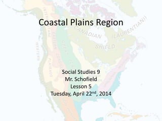
8. Coastal Plains Region
Textbook Pg. 166-167
• Description
• Provinces / States
• Cities
• Topography
• Climate
• Vegetation
• Bodies of water
• Historical Details
9. What Do You Already Know …
… about this region?
• Think-Pair-Share with a neighbour
• Write down your ideas (single words)
10.
11. Geographic Features
Description–
• Lowland area
• 3,200 km along Atlantic Coast & Gulf of Mexico
• 50 – 100 km inland
• Rapid water flowing from Appalachian Mtns
• Heavily populated region
• Vulnerable to stormy weather
12. Geographic Features
Provinces: n/a
States: Vermont, New
Hampshire, Massachusetts, Rhode
Island, Connecticut, New
Jersey, Delaware, Pennsylvania, Maryland, Virgini
a, North Carolina, South
Carolina, Georgia, Florida, Alabama, Mississippi,
Louisiana, Arkansas, OklahomaTexas
Other: Mexico, Belize, Guatemala
13.
14. Geographic Features
Cities: Boston, New York, Philadelphia,
Washington, Norfolk, Wilmington, Charleston,
Jacksonville, Tallahassee, Orlando, Miami,
Montgomery, Columbus, New Orleans, Houston,
San Antonio, Birmingham, Cancun, Belize City
15.
16. Geographic Features
Topography –
Avg. elevation of < 200 m above sea level
• Swamps – wet, spongy land
• Marshes – low land that is flooded in wet
weather and almost always wet
• Deltas – areas of soil or silt deposits built up
at the mouth of a river
17.
18.
19.
20.
21.
22. Geographic Features
Climate –
Cold, snowy winters; hot, humid summers in North
Mild to warm winters; hot, stormy summers in South
• Hurricanes
• Storms
• Floods
Celsius Fahrenheit: °C x 9/5 + 32 = °F
Fahrenheit Celsius: (°F - 32) x 5/9 = °C
32. Hurricane Katrina
• Total fatalities: 1,833
• Highest winds: 280 km/h
• Lowest pressure: 902 mb
• Date: August 23, 2005 – August 30, 2005
• Category: Category 5 Hurricane (SSHS)
33.
34.
35.
36.
37.
38.
39.
40.
41.
42.
43.
44.
45. Closing
• Do you have any questions?
– Write down 1 thing you learned
– Write down 1 thing you found confusing
• Homework: Complete Journal Side of Form
• Next Class:
– We will move on to the Great Lakes Region
– Remember to sign-up for the current events