Doan Brook Gorge Walking Tour
•Download as PPTX, PDF•
1 like•939 views

This document announces a walking tour of Doan Brook Gorge on June 7, 2014 hosted by the Doan Brook Watershed Partnership and Natural History Museum. The tour will explore the geological features of the gorge including bedrock exposures from the Devonian period 370 million years ago. It will also examine the natural and cultural history of the gorge and surrounding area. Participants are asked to RSVP by contacting the email provided. The event is part of a series of history hikes exploring the human impact and development of the gorge over time from early settlers to modern suburbanization.

Recommended
More Related Content
What's hot
What's hot (20)
Similar to Doan Brook Gorge Walking Tour
Similar to Doan Brook Gorge Walking Tour (20)
More from Bluestone Heights
More from Bluestone Heights (13)
Recently uploaded
Recently uploaded (20)
Doan Brook Gorge Walking Tour
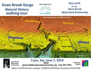
- 1. Doan Brook Watershed Partnership 3 pm, Sat, June 7, 2014 Roy Larick Bluestone Heights Doan Brook gorge, looking southeast Doan Brook Watershed Partnership USGS LiDAR underlay; Google Earth aerial viewer for the Maple RidgeTurkey Ridge RSVP gilmore@doanbrookpartnership.org 216-325-7781 Doan Brook Gorge walking tour With support from Natural History Meet: Fairhill Partners campus: 12200 Fairhill Road, Cleveland, OH 44120
- 2. Doan Brook gorge, looking southeast Between Turkey and Maple Ridges, glacial melt water carved sandstone and shale. Bedrock exposures evince the Age of Fishes sea of 370 million years ago. The Natural History gorge hike explores the bedrock and the deep history of fast-changing natural and cultural features. USGS LiDAR underlay; Google Earth This event sets the stage for history hikes on the gorge’s Early Settlers (8/23) and Suburbanites (19/18). Maple Ridge Turkey Ridge
- 3. Doan Brook rocks During the Late Devonian Period, 370 million years ago, our region lay near the Equator, in the Ohio Basin Sea. The nearest land was 150-200 miles to the east. Chagrin and Cleveland Shale fossils indicate a muddy sea bottom. The sea had many fish; few were fossilized. Redrawn from Hannibal & Feldmann The Explorer 27(1), 1985 Age of Fishes Ecology
- 4. Doan Brook and the Portage Escarpment Just 23,000 years ago, the last glacial advance bulldozed the Portage Escarpment to create two terraces, one atop the Berea Sandstone and, just below, atop the Euclid bluestone. To create its gorge, Doan Brook cut through these hard rocks and underlying soft shale. Gulch and Gulf In early settler days, a deep ravine with craggy cliffs could be called a gulch. A wider ravine with vertical sides could be called a gulf. In the Berea Sandstone, Doan Brook carved its gulch. In the bluestone and underlying shale, the brook dug its gulf. Doan Brook Gorge
- 5. © 2014 Bluestone Heights moraine west tip Delaware ravine. Top lip of the gulch. Doan Brook Gorge Euclid bluestone gulf landscape Berea Sandstone gulch landscape Gulf S wall, above Fairhill. Bluestone level near top. Gulf S bank, upstream from MLK. Bluestone level near bottom. NCSL In the Berea gulch. Transition from massive to flaggy beds. Cleveland Memory Project CMP W.C. BarrowTurkey Ridge Maple Ridge North Ambler Heights USGS LiDAR underlay Google Earth aerial viewer stone culvert Gulf S cliff. Fine flaggy bedding at top of the Berea sequence. Trough cross- bedding within the Berea flaggy beds. Cle Water Dept Gulch N cliff, 1894, view W to grist mill ruins. Gulf N wall, above North Park. Bluestone level near top. gulf & gulch R. Larick R. Larick R. Larick Cleveland Memory Project R. Larick
- 6. Doan Brook Watershed Partnership 3 pm, Sat, June 7, 2014 Roy Larick Bluestone Heights Doan Brook gorge, looking southeast Doan Brook Watershed Partnership USGS LiDAR underlay; Google Earth aerial viewer for the Maple RidgeTurkey Ridge RSVP gilmore@doanbrookpartnership.org 216-325-7781 Doan Brook Gorge walking tour With support from Natural History Meet: Fairhill Partners campus: 12200 Fairhill Road, Cleveland, OH 44120