International Journal of Engineering Research and Development
•
2 likes•823 views

Electrical, Electronics and Computer Engineering, Information Engineering and Technology, Mechanical, Industrial and Manufacturing Engineering, Automation and Mechatronics Engineering, Material and Chemical Engineering, Civil and Architecture Engineering, Biotechnology and Bio Engineering, Environmental Engineering, Petroleum and Mining Engineering, Marine and Agriculture engineering, Aerospace Engineering.

Recommended
Recommended
More Related Content
What's hot
What's hot (17)
Similar to International Journal of Engineering Research and Development
Similar to International Journal of Engineering Research and Development (20)
More from IJERD Editor
More from IJERD Editor (20)
Recently uploaded
Recently uploaded (20)
International Journal of Engineering Research and Development
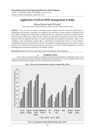
- 1. International Journal of Engineering Research and Development e-ISSN: 2278-067X, p-ISSN: 2278-800X, www.ijerd.com Volume 10, Issue 10 (October 2014), PP.24-32 Application of GIS in MSW management in India. Meena Deswal and J.S Laura* Department of Environmental Sciences, M.D.University, Rohtak-124001, India Abstract:- Over the past few decades increasing human population and the associated phenomenon of urbanization and economic development has resulted in the generation of huge quantities of municipal solid waste (MSW). Management of huge dumps of MSW has become a challenge in most cities in India It involves several activities, which can be categorized into: collection, transportation and disposal of waste. This evolution had been driven by significant advances in computer technology and availability and quantity of data. As the complexity of the management increases there is requirement of computerized software to do the analysis. Geographical Information System (GIS), software’s are capable of handling spatial data along with non spatial attributes. The software also has the provision for querying. Use of GIS in MSW management can help in leapfrogging the management technology in developing countries. Keywords:- Bin placement, Route optimization, Dump-site Selection, Waste Estimation I. INTRODUCTION One of the most obvious impacts of rapidly increasing human population is urbanization (Fig.1) and economic development. The trend of increase in population and urbanization is even more rapid in India. Urban population growth in India is higher than the overall population growth (Fig.2). Fig. 1 -The world is becoming more urban (Annepu, R.K., 2012) Fig. 2 -Urbanisation trend in India (Annepu, R.K., 2012). 24
- 2. Application of GIS in MSW management in India. Increasing human population and the associated phenomenon of urbanization has resulted in increased residential, commercial, infrastructural development and economic status development and it can be witnessed in the form of heaps of municipal solid waste. In general, a 1% increase in population is associated with a 1.04% increase in the solid waste generation, and a 1% increase in per capita income is associated with a 0.34% increase in total solid waste generation (Wang et al, 2011). Solid-waste management has become a major challenge in urban areas throughout the world. Without an effective and efficient solid-waste management program, the waste generated from various human activities, both industrial and domestic, can result in health hazards and have a negative impact on the environment and human beings. (Bhambulkar, 2011). (Jilani, (2002), Suchitra, (2007). It is estimated that about 10% of each person’s production life is lost as a result of waste related disease (Al Ansari et al, 2012). Solid waste management is a complicated process as it requires considerable expertise, in social and environmental field such as engineering, soil sciences, land use, hydrogeology, topography, sociology and economics, apart from these considerations legislations and rules also have to be taken into consideration. It involves several activities which can be categorized into collection, transportation, volume reduction, recycling and disposal. For a complete waste management system, a vast knowledge and scientific analysis must be done on all necessary criteria’s like characteristics of generated waste, economic value of waste, its proper temporary storage, collection and scientific and cost effective dumping to a landfill. As the solid waste generation increases the complexity of management increases and there is need of specific management system which gives the systematic and fast way of management. Out of the various steps in municipal solid waste management each step in the process requires input or multifactor data in spatial as well as non spatial form. The scientific and systemic management of MSW involves processing of the significant amount of the spatial data, acceptable criteria’s and regulations with efficient correlation between them. For proper decision all inputs have to be considered together at once and correlated. As the complexity of the management increases there is requirement of computerized software to do the analysis. In recent years, Geographical Information System (GIS) has emerged as a very important tool for decision making in management practices of solid waste. Geographical Information System (GIS), software’s are capable of handling spatial data along with non spatial attributes. GIS can recognize, analyze and correlate the spatial relationship between mapped phenomena, the software also has the provision for querying thereby enabling policy makers to link disparate sources of information, perform sophisticated analysis, visualize trends, project outcomes and strategize long term planning goals (Malczewski, 2004). GIS has been found to play a significant role in the domain of bin site selection, route optimization for collection and siting of the waste disposal sites. 25
- 3. Application of GIS in MSW management in India. GIS based approach not only reduces the time and cost of system management, but also provides a digital data bank for long term monitoring of the management system. GIS also play a key role in maintaining account data to facilitate collection operation and provide customer services, analyzing optimal locations for transfer stations, planning routes for vehicle transporting waste to transfer station and from transfer station to landfills, as well as long term monitoring of landfills. Along with proliferation of GIS technology, multiple criteria decision making methods (MCDM) have evolved as a major tool to assist decision makers with analyzing and solving multiple criteria decision problems. II. REVIEW OF LITERATURE Presented in this paper is a review of the work done using GIS tools in the management of municipal solid waste in India. The literature is reviewed under the following headings. 1. Estimation of waste generation, 2. Temporary storage bin placement, 3. Waste collection route optimization, 4. Dumpsite selection, 5. Miscellaneous Applications 26 1. Estimation of Waste Generation For proper selection of bin size, placement and frequency of collection, spatial population density and waste emission estimates are essential inputs for SWM planning. Shoba and Rasappan (2013) discussed the process for population density and waste emission estimation in a study area of Coimbatore district of Tamil Nadu. Population distribution map is prepared thematically to identify area based on population and Natural break classifier is used to classify the population into six classes, to classify the waste generation and distribution of ward workers. Inventory questionnaire used for data on solid waste generation, collection, treatment and disposal. ArcGIS used for analysis of data. Katpatal and Rao (2010) developed a computer based information systems which offers decision making capabilities based on expert knowledge available through integration of alphanumeric information with geographic parameters. The main emphasis of the study was to characterize the solid waste within Nagpur urban area and generate coefficients for estimating quantities of the waste components for various land use classes spatially. Satellite data and linear regression analysis technique was used to generate indices for computing physical and chemical characteristics of solid waste for residential land use classes. 2. Waste Temporary Storage Bin Placement Proper bin placement and temporary storage is an important operation on the road to an efficient SWM plan. Size capacity of bin, location, convenience, proximity to road and frequency of collection are some of the parameters to be taken while planning for bin placement and temporary storage of waste. Use of GIS tools in the planning stage has been used as discussed here. Nithya et al(2012) developed a DSS for locating new bins in one of the main urban area Sidhapudur ward in Coimbatore city, India. Study helps in analyzing the MSW collection issues and used as a decision supporting tool for efficient collection of MSW in the ward. GIS spatial technique used for development of decision supporting tool. Three conflicting objectives are evaluated review current MSW management practices including waste generation, location of collection bins, type & size of collection bins and collection frequency of MSW removal from bins, to find and allocate new collection bins based on MSW generation and find optimal proximity distance for the collection bins by generating buffer zone. Geospatial database was framed in ArcGIS for the allocation and analysis of collection bins. The guidelines of WHO and statement of Shaikh Moiz Ahmed (2006) and Illeperuma.I.A.K.S et al (2010) were considered for collection bin site selection. Senthi et al (2012) reports the present scenario of inconvenient bin placements in ward (number 45) in Kumbakonam town, Tamil Nadu, India. Dust bins were not used by all households due to lack of accessibility and inconvenience as the location of bins is not found in optimum location. Settlement map was prepared which shows linear, cluster and nucleus type of settlement in this area. On behalf of settlement the population of particular street and collection of household waste from individual house were estimated and then the suitable location of waste bin were selected. Centroid Analysis with the help of GPS survey and Arc GIS were used which shows the Centroid Settlement Pattern of the ward. By using SPSS v16. software, the co-ordinates and the settlement data Weighted Mean Center (WMC) has been applied to extract the alternate location of dust bins. 3. Waste Collection Route Optimization Collection and transportation is the most important and costly aspect of the MSWM cycle because of the labor intensity of the work and the massive use of the trucks and fuel consuming machineries in collection process it is responsible for 70-80% of total waste management cost (Karadimas et al, 2007, Lasaridi et al
- 4. Application of GIS in MSW management in India. ,2006., Nithya et al, 2012). This amount is much higher than the typical value, between 50-70% reported for modern waste management system (Sonesson, 2000).The waste collection, transport methods depends on the specific site, waste generated, road network, manpower, vehicles and treatment methods (khajuria et al.2010). Integration of GIS technology with MSWM has been recognized as one of the most promising approach to automate the process of planning and better management of MSW and reduction in cost of transport operations (Karadimas and Loumos, 2008, Rahman, 2011). Sudhir et al. (1996) discussed the problem of implementing a solid waste collection system in India. They considered multi-objective decision making approach taking economic, environmental, technical and social aspects. The approach is based upon multi-objective lexicographic goal programming taking into account several possible scenarios. The proposed model considers a single planning period of 5 years, and was used to study SWM in Madras city. Ghosh et al. (2006) considered allocation of available resources (man power and vehicles) and suggested an expert system based decision support tools for solid waste transportation management. A case study of Asansol district revealed that the cost of collection and transportation of MSW could be reduced by 60% using GIS based route planning of vehicles for the purpose. Reddy and Padmaja (2007) worked on development of a GIS based decision support system for optimal route analysis for transportation of solid waste. The objective was to develop a decision support system for finding a suitable route for transportation of solid waste in Hyderabad using remote sensing (RS), GIS and GPS technologies. The DSS gives information regarding the existing waste disposal sites in and around Hyderabad, detailed transportation network of the city and probable routes suitable for transportation of wastes. Kanchanabhan et al. (2010) have proposed a GIS based collection and transportation model for MSWM and test checked it for Pallavapuram municipality. A GIS-based routing model was used to develop an optimal route map for efficient transport system. The parameters considered included population density, waste generation capacity, road network, storage bins and collection vehicles. The developed route map could be used to trace the minimum distance as well as efficient collection paths for transporting the solid waste from collection points to final disposal site through transfer stations. The proposed model can be used as a decision-support tool by the municipal authority for efficient management of the daily operations for moving solid waste, load balancing within vehicles, managing fuel consumption and generating work schedules for the workers and vehicles. Khajuria et al. (2011) discussed the problem in Chandigarh City, India. An integrated Municipal Solid waste Management assessment model is proposed and used as a decision support system tool for daily efficient operations such as collection and transportation path management, load balancing within vehicles, fuel consumption management by using GIS applications. A simple optimal routing model is proposed to achieve the minimum Cost/distance/time efficient collection and transport path for MSWM. Siddam et al. (2012) attempted to optimize the route for collection and transportation of municipal solid waste Chandrapur town of Maharashtra state. Georeferencing and rectification done through ERDAS Imagine 9.1 and digitization by ARC-GIS 9.2. Network dataset prepared from road network using ARC –Catalogue. Solid waste bin location were collected using GPS survey. For optimization of collection route stops, barriers, nature of the road was taken into consideration. Through Geo-informatics management of solid waste, 50% reduction in expenditure was realized. Velumani (2013) have proposed GIS based Optimized Route Model for the collection of waste at Singanallur ward at Coimbatore city of Tamil Nadu. The network Module of Arc/Info GIS software was used to find the shortest or minimum impedance path through a network. In this analysis the collection frequencies are proposed for the collection of degradable and recyclable wastes based on the size of bin and the quantity of wastes generated. Through this study it was estimated that the total collection distance of 46% is saved and 86.7% benefit in expenditure in the running and maintenance of vehicle due to optimization of collection routes. 27 4. Dumpsite Selection Sanitary landfill siting requires an extensive evaluation process and requires considerable inputs from environmental field such as engineering, soil sciences, land use, hydrogeology, topography, sociology and economics in order to identify the optimum available disposal locations. This location must also comply with the requirements of the existing governmental regulations and at the same time must minimize economic, environmental, health, and social cost (Siddiqui et al, 1996). Natesan and Suresh (2002) developed a GIS based decision support system for sanitary landfill site selection. The themes identified for the purpose included land use, geology, geomorphology, drainage density, slope, soil and runoff. The factors considered for selecting the themes were permeability characteristics, susceptibility to erosion, runoff, settlement and load carrying capacity of the strata, lineaments, absence of faults and joints, slope of the ground and ground water potential. The scores for various themes and their attributes were assigned using four Multi Criteria Evaluation (MCE) models viz. Analytical Hierarchy Process (AHP), Factor importance Coefficient (FIC) Artificial Neural Network (ANN) and Delphi. The results of all the models were compared to find out the best possible site. The method was applied in the Chennai Metropolitan Development Area (CMDA), Chennai, India. Reddy (2005) described development of a Multi-Criteria Decision Support System (MCDSS) for optimum solid waste management. The developed DSS was designed for the
- 5. Application of GIS in MSW management in India. towns and municipalities in Medak district (India). The work involved examining the status of solid waste generation by assessing the existing solid waste management system and creation of digital database on ArcGIS plateform to develop multi-criteria Decision Support System (DSS) for optimal solid waste management. The design and development of DSS comprised of data management module, data validation and analysis module, module that is capable of analyzing the generated data in to different categories, transfer station capacity module, module to calculate site sensitivity index (SSI), and selection criteria for disposal site evaluation. Padmaja et al. (2006) described development of Decision Support System (DSS) for identification of solid waste disposal site in Hyderabad using Remote Sensing and GIS. The role of GIS techniques in mapping and analyzing the thematic layers prepared from remote sensing data for identification of suitable solid waste disposal site was demonstrated. The study also demonstrated how the required in situ data and remotely sensed data can be placed in a GIS system to model and identified the waste disposal site for Hyderabad City. The methodology developed for finding suitable site provide information regarding the existing solid waste disposal sites provide information regarding the existing solid waste disposal sites as well as probable sites suitable for waste disposal around Hyderabad. The DSS developed was suggested to be useful for decision makers in Municipal Corporation of Hyderabad and urban developmental activities. Sumathi et al. (2008) developed a GIS- based system for optimized municipal solid waste landfill site selection. The selection of a new landfill site was done using a multi-criteria decision analysis (MCDA) and overlay analysis in GIS environment. The proposed system can accommodate new information on the landfill site selection by updating its knowledge base. The guidelines of Central Pollution Control Board, India (CPCB,2003) and Central Public Health and Environmental Engineering Organization ( CPHEEO, 2000) were considered for landfill site identified. The selection of disposal site was carried out through multi-level screening process. A GIS- based constraint mapping was employed to eliminate the environmentally unsuitable sites and to narrow down the number of sites for further consideration. Analytic hierarchy process (AHP) was employed to give weights to different criteria based on expert opinion. Criteria were lake and pond, rivers, water supply sources, ground water table, ground water quality, infiltration, air quality index, geology, fault line, elevation, land use, habitation, highways, and sensitive area. Using the comparison matrix among the alternatives and the information on the ranking of the criteria, AHP generated an overall ranking of the sites. The multi-criteria analysis was performed using the spatial modeler of ArcGIS. The effectiveness of the developed system was tested at Union Territory of Pondicherry (India). Kumar and Hassan (2012) developed a multi-criteria decision making process by Spatial Analytical Tool along with Analytical Hierarchy Process (AHP) model for selection of suitable dumpsite. The landfill selected by consideration of many criteria such as distance from residential location, transport connectivity, presence of water-bodies (drains, ponds, rivers etc.), forests, ground water table and geology while planning. Pair wise comparison of criteria by cross- analysis used for final weightage of each criteria. All the criteria/ constraints were overlaid with the weightages derived from AHP model and then a spatial analysis technique was applied. The developed multi-criteria decision making process used to identified a suitable location for landfill site in a part of National Capital Territory of Delhi. Six potential suitable sites were sorted out from one is the most suitable. Shukla et al (2012) explains an approach for identifying the optimum site for disposing solid waste in a typically urbanizing city Roorkee, Uttarakhand, India. The criteria developed on the basis of criteria used by International Organizations and Indian legislation and policies on waste disposal. Decision making process for selecting suitable site for disposing solid waste has been structured into three phases- Analysis phase, Decision phase and Suitability Phase. all criteria has been divided into three categories- Planning (sensitive location, population density, proximity to road, civil construction condition), Environment (soil subsidence, surface water and drainage, atmospheric condition) and Resource (agriculture land, forest, park, historical location and archeological site). Constraints criteria have been organized as a set of Boolean rules and factors has been organized as a set of fuzzy rules with a degree of linear membership. Weighted linear combination method has been used for aggregating all constraints and factor with their relative weights. Criteria map based on Constraint and Factor maps in which constraint map includes land use, surface water road, lower elevation, sensitive location, water level and Factor maps includes proximity to road, public health and safety and proximity to urban area. Choudhari and Das (2012) determine the suitable site for the disposal of urban solid waste generated from Dharmanagar Nagar Panchayat in the North Tripura District of Tripura State. Through GIS landfill siting decision was marked. Criteria were selected according to study area local characteristics and for spatial analysis principal sub criteria were made named as Lithology, Geomorphology, Slop, Drainage, Population, and Distance from major Roads, major Streams, and Drainage. Weightage were allotted to principal Sub criteria on the basis of key factors. Spatial analyst extension of Arc Map was used for the analysis of all raster dataset for different layers having different score were over layed and the scores of each composite class were added. 5 Km of buffer area of study area has been considered for selection of proper landfill site. Khan and Samadder (2014) presented a method based on Geographical Information System (GIS) modeling to identify a set of criteria which needs to be considered for the proposed MSW landfill site in the city. The integration of GIS and Analytical Hierarchy Process (AHP) is a powerful tool to solve the landfill site 28
- 6. Application of GIS in MSW management in India. selection problem because GIS provides efficient manipulation and presentation of the data and AHP supplies consistent ranking of the potential landfill area based on a variety of criteria. They suggested 11 input map layers including topography, settlements (urban centers and villages), roads (Highway and local roads), slop, geology, land use, floodplains, aquifers and surface water should be evaluated. For weightage determination, pair wise comparisons of the criteria’s by which two components are considered at a time which resulted in the reduction of complexity. The information compiled from literature about the safe distances to a landfill site is used to determine the buffer zones for each layer. After buffering each layer is converted into individual raster maps. After the preparation of all input data layers, the method AHP is Selected among the decision rules to analyze the data for landfill site selection by using GIS and hence the output map is prepared. Saxena and Srivastava (2011) discussed a problem of suitable site selection of dumpsite in Allahabad city of Uttar Pradesh (India). Different Constraints considered as per site selection criteria provided by CPCB, MoEF, Government of India. For the selection of suitable site buffer of different feature class in different thematic layers has been created based on bed Rock depth, slop of ground, water table depth, soil types, river, lakes, habitation, power lines, water supply wells and erase tool in Spatial Analyst tool of ArcGIS has been used to erase buffer of each feature class from the search area to erase all the unwanted area. Thus the remaining area was the potential area which provides the potential sites for site selection. 29 5. Miscellaneous Applications Singh and Ohri (2009) reported the development of a standalone GIS based EDSS for solid Waste Management using VB. NET and ArcGIS Engine programming tools. The developed EDSS consisted of six modules dealing with six functional elements of SWM: ‘Estimation of Waste Generation’, ‘Onsite Operation’, ‘Primary Collection’,’Transportation’,’Resource Recovery’ and ‘Disposal’. The developed EDSS-MSW was test checked for municipal solid waste management of Varanasi city. Saxena et al. (2010) developed a DSS for sustainable municipal solid waste management of Allahabad City (India). Both economical as well as environmental sustainability of municipal solid waste management were considered. Technological aspects, institutional aspects and financial aspects were taken in the framework of integrated approach. Technological aspects included incorporation of GIS in the database for waste related procedures such as waste generation, collection, treatment and disposal. The conceptual framework for the technological aspect of overall solid waste management were categorized and worked out with four modules, namely: waste generation module. Institutional aspects considered identification of strengths, weaknesses, opportunities and threats (SWOT) of working bodies governing the solid waste management system. The financial aspect considered factors for reducing the direct economic burden on the municipality authorities by option of tariff from households, commercial places, academic institutions and other waste generators. John (2010) considered a sustainability-based decision-support system for solid waste management. A sustainable alternative for diversion of household waste from the landfill site in Sahibzada Ajit Singh Nagar, a planned growing town of Punjab (India) was explored. Backyard composting or vermin composting, Centralized composting of source segregated organic waste, and Centralized composting of mixed waste were considered as the three alternatives of analysis. Based on six identified criteria for sustainability of municipal solid waste processing methods, multi-criteria decision matrix involved the identification of different sustainability factors and parameters on the basis of socio-technical survey in this study area. Centralized composting of source-segregated organic waste was found to be the most feasible alternative under given conditions. Backyard composting or vermin- composting and centralized composting of mixed waste were found second and third in successive preferences on sustainability criteria in decision making. Table 1: Chronological order of DSS and GIS in Municipal Solid waste Management in India. S.No Authors Techniques Area of Application Study Location 1 Sudhir et al. (1996) Multi-objective decision making approach Waste collection system Tamil Nadu (Chennai) 2 Natesan and Suresh (2002) GIS based decision support system, MCE models: AHP, FIC, ANN and Delphi Landfill site selection Tamil Nadu (Chennai) 3 Reddy (2005) ArcGIS platform Data Management, Validation and Analysis module. Through these modules transfer station capacity, site sensitive index (SSI) and suitable site for landfill were selected. Medak (Maharashtra) 4 Ghosh et al. (2006) Rout planning using GIS Collection and Transport Route Planning. Asansol (West Bengal)
- 7. Application of GIS in MSW management in India. 30 5 Padmaja et al (2006) Remote Sensing and GIS, DSS. Disposal site selection. Hyderabad (Andhra Pradesh) 6 Reddy and Padmaja (2007) GIS based DSS (Decision Support System). Optimal Rout Analysis for transportation of waste. Hyderabad (Andhra Pradesh) 7 Sumathi et al (2008) MCDA (Multi- Criteria Decision Analysis), Analytical Hierarchy Process, ArcGIS. Dumpsite selection. Pondicherry (India) 8 Singh and Ohri (2009) ArcGIS and NET Engine programming tools. Estimation of waste generation, onsite operation, primary collection, transportation, resource recovery and disposal. Varanasi city (Uttar Pradesh) 9 Saxena et al (2010) ArcGIS tools, DSS. Sustainable municipal solid waste management, Technological, Institutional and financial aspects. Allahabad City (Uttar Pradesh) 10 Kanchanabhan et al (2010) GIS based collection and transportation model. Optimal Route map Pallavapuram 11 Katapatal and Rao (2010) Satellite data and Linear regression analysis. Charaterize solid waste and generate coefficient for estimating quantitity of waste components. Nagpur (Maharashtra) 12 John (2010) Sustainability based decision support system. Composting Sahibzada Ajit Singh Nagar (Punjab) 13 Saxena And Srivastava (2011) Consider constraint, Spatial analysis tool of ArcGIS. Dumpsite Selection Allahabad City (Uttar Pradesh) 14 Choudhury and Das (2012) Arc Map GIS through Spatial Analysis Extention and weightage for the principal criteria. Waste Dumpsite selection. Dharmanagar town (Tripura) 14 Shukla et al (2012) ArcGIS, Criteria map based on constraint and factor map. Landfill Site Selection Roorkee, (Uttarakhand) 15 Siddam et al (2012) ERDAS Imagine 9.1 and Arc- GIS 9.2. Through network dataset preparation and network analyst tool utilization optimized route selected. Route optimization Chandrapur town (Maharashtra) 16 Nithya et al (2012) ArcGIS Location of bins Sidhapudur ward Coimbatore (Tamil Nadu) 17 Senthi et al (2012) SPSS v16 software, weighted mean center (WMC) for extraction of alternate location of dust bin. Bin placement and settlement map. Kumbakonam town (Tamil Nadu) 18 Kumar and Hassan (2012) Application of Analytical Hierarchy Process and Spatial Analyst Tool. Suitable landfill site selection National Capital Territory (Delhi) 19 Khajuria et al Optimal Routing Model and Optimization of Routing System Chandigarh
- 8. Application of GIS in MSW management in India. (2011) Decision Support Tool and characterization of 31 municipal solid waste. 20 A. Velumani (2013) Arc/Info GIS and GPS. Bin Placement and Route Optimization Model. Singanallur ward of Coimbatore (Tamil Nadu) 21 Shoba and Rasappan (2013) Population density and waste generation estimation Analysis by ArcGIS and Natural Break classifier for classification of population, waste generation and distribution of ward workers. Coimbatore (Tamil Nadu) 22 Khan and Samaddar (2014) Suggest Arc GIS Suggest criteria and methodology for Landfill site selection. - REFERENCES [1]. Al-Ansari, N.K, Hanbali, A.Al., and Knutsson, S. (2012). Locating Solid Waste Landfills in Mafraq City, Jordan. Advance Science and Engineering Research, 2(1),40-51. [2]. Annepu, R.K., (2012). Sustainable solid waste management in India. Master’s Thesis in Earth Resource Engineering, in Columbia University in the city of New York. [3]. Bhambulkar, A.V., (2011). Municipal Solid Waste Collection Routes Optimized with ARC GIS Network Analyst. Advanced Engineering Sciences and Technologies, 11(1), 202-207. [4]. Chaudhary, S., and Das, S., (2012). GIS and Remote Sensing For Landfill site selection- A case study on Dharmanagar Nagar Panchayet. IOSR Journal of Environmental Science, Toxicology and Food Technology (IOSR-JESTFT), 1(2), 36-43. [5]. Ghose, M.K., Dikshit, A.K., and Sharma, S.K., (2006). A GIS based transportation model for solid waste disposal- A case studyon Asansol municipality. Journal of Waste Management, 26:1287-1293. [6]. Illeperuma, I.A.K.S., and Koon, S., (2010). Locating bins using GIS. International Journal of Engineering and Technology, 10(2). [7]. Jilani, T., (2002). State of solid waste management in Khulna City. Environment Science Discipline, Khulna University Khulna, Bangladesh, 25-85. [8]. John, S., (2010). Sustainability-based decision-support system for solid waste management. International Journal of Environment and Waste Management, 6 (1-2),41-50. [9]. Kanchanabhan, T.E., Mohaideen, J.A., Srinivasan, S., and Sundaram, V.L.K., (2010). Optimum municipal solid waste collection using geographical information system (GIS) and vehicle tracking for Pallavapuram municipality. Journal of Waste Management & Research. [10]. Karadimas, N.V., and Loumos, V.G., (2008). GIS- Based Modeling for the Estimation of Municipal Solid Waste Generation and Collection. Waste Management and Research, 26, 337-346. [11]. Karadimas, N.V., Papatzelou, K., and Loumos, V.G., (2007). Optimal Solid Waste Collection Routes Identified by Ant Colony System Algorithm. Waste Management and Research,25,139-147. [12]. Katpatal, Y.B., and Rama Rao, B.V.S., (2010). Urban spatial decision support system for municipal solid waste management in Nagpur urban area using high resolution satellite data and GIS. Journal of Urban Planning and Development. [13]. Khajuria, A., Matsui, T., and Machimura, T., (2011). GIS Application for Estimating the Current Status of Municipal solid Waste Management System: Case Study of Chandigarh City, India. Journal of Our Nature, 9, 26-33. [14]. Khan, D., and Samadder, S.R., (2014). Application of GIS in Landfill Siting for Municipal Solid Waste. International Journal of Environmental Research and Development, 4 (1),37-40. [15]. Kumar, S., and Hassan, M.H., (2012). Selection of a Landfill Site for Solid Waste Management: An Application of AHP and Spatial Analyst Tool. Journal of Indian Soc Remote Sens. DOI 10.1007/s12524-011-0161-8. [16]. Lasaridi, K., Rovolis, A., Abeliotis, K., (2006). Waste Management Costs in Greece: Spatial patterns and Casual Factors. WIT Transactions on Ecology and the Environment, 98, 55-64. [17]. McHarg, I.L., (1969). Design with nature. The Natural History Press, Garden City, NY. [18]. Nateshan, U., and Suresh, E.S.M., (2002). Site suitability evaluation for locating sanitary landfills using GIS. Journal of Indian Society of Remote Sensing, 30(4). [19]. Nithya, A.R., Velumania, I.A., and Senthil Kumar, S.R.R., (2012). Optimal Location and Proximity Distance of Municipal Solid Waste Collection Bin Using GIS: a Case Study of Coimbatore City. WSEAS Transaction On Environment And Development, 4(8).
- 9. Application of GIS in MSW management in India. [20]. Padmaja, V., Asadf, S.S., and Anji, M.R., (2006). Solid waste disposal site selection using analytical hierarchy process and GIS. Pollution Research, 25 (1), 73-76. [21]. Rahman, S., (2011). Application of GIS Techniques In Urban Solid Waste Management in a part of Dhaka City: Mohammadpur Thana. Journal of Sustainable Development and Environment Protection, 1(2). [22]. Reddy, M.A., and Padmaja, V., (2007). Development of GIS based decision support tool for optimal rout analysis for transportation of solid waste. Proceeding of 22nd International Conference on Solid Waste Technology and Management Phiadelphia PA USA, March 18-21. [23]. Reddy., (2005). Analytical Hierarchy Process (AHP) – GIS Model for Landfill siting: A case study of Hyderabad City, India. International Conference on Environmental management (ICEM-2005) from 28-30 October, Hyderabad. [24]. Saxena, S., and Srivastava, R.K., (2011). GIS For Site Selection For MSW Landfills. Proceeding of Indian Geotechnical Conference, Kochi, Paper No M-003. [25]. Saxena, S., Srivastava, R.K., and Samaddar, A.B., (2010). Towards sustainable municipal solid waste management in Allahabad City. Journal of Management of Environment Quality, 21(3), 308-323. [26]. Senthi, J., Vadivel, S., and Murugesan, J., (2012). Optimum Location of Dust Bins Using Geo-Spatial Technology: A Case Study of Kumbakonam Towm, Tamil Nadu, India. Advances in Applied Sciences Research, 3(5), 2997-3003. [27]. Shaikh Moiz Ahmed., (2006). Using GIS in solid waste management planning-A case study for Aurangabad, India. Master’s Thesis, IDA, Linköpings University, Sweden, 1-66. [28]. Shoba, B., and Rasappan, K., (2013). Application of GIS in Solid Waste Management for Coimbatore City. International Journal of Scientific and Research Publications, 3(10). [29]. Singh, P.K. and Ohri, A., (2009). Development of environmental decision support system for municipal solid waste management in India, in the 24th International Conference on Solid Waste Technology and Management ICSW 2009 proceedings of the international conference in Philadelphia, PA U.S.A., March 15-18, 2009, 210-221. [30]. Siddam, S., Khadikar, I., and Chitade, A., (2012). Rout Optimization for Solid Waste Management Using Geo-Informatics. IOSR Journal of Mechanical and Civil Engineering (IOSRJMCE), 2(1), 78-83. [31]. Siddiqui, M.Z., Everett, J.W., and Vieux, B.E., (1996). Landfill sitting using geographic information systems: a demonstration. Journal of Environmental Engineering, 122 (6), 513-523. [32]. Sonesson, U., (2000). Modeling of Waste Collection- A General Approach to Calculate Fuel Consumption and time. Waste Management and Research, 18(2),115-123. [33]. Suchitra, M., (2007). Outside: Burned or Buried, garbage needs land. Down to Earth, 22-24. [34]. Sumathi, V.R., Natesan, U., and Sarkar, C., (2008). GIS-based approach for optimized iting of municipal solid waste landfill. Journal of Waste Management, 28, 2146-2160. [35]. Shukla, G., Shashi, M., and Jain, K., (2012). Decision Support System for Selecting Suitable Site for Disposing Solid Waste of Township. International journal of Remote Sensing and GIS, 1(1), 2-11. [36]. Velumani, A., (2013).GIS based Optimal Collection Routing Model for Municipal Solid Waste: Case study in Singanallur. International Journal of Engineering and Innovative Technology (IJEIT), 3(5). [37]. Wang, H., He, J., Kim, Y., and Kamatta, T., (2011). Municipal Solid Waste Management In Small Towns: An Economic Analysis Conducted in Yunnan, China. Policy Research Working Paper, 57-67. [38]. World Bank, (2006). Improving Management of Municipal Solid Waste in India, Overview and 32 Challenges. World Bank.