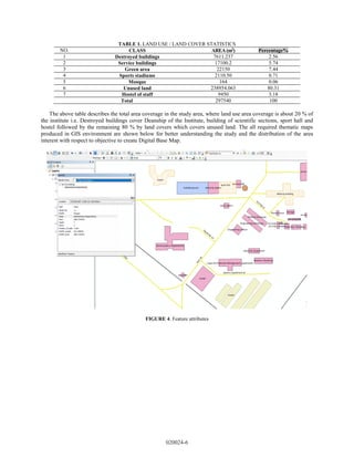
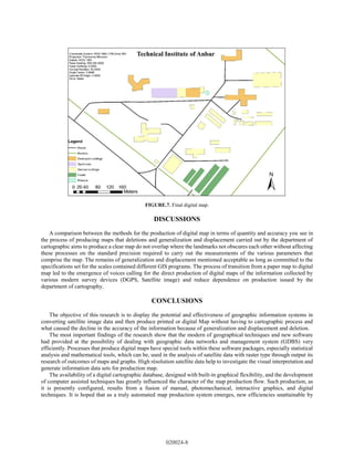
This document summarizes a study that used remote sensing and GIS techniques to produce a digital land use map of the Technical Institute of Anbar in Iraq. Satellite imagery and attribute data were collected and digitized in ArcGIS to create vector data layers representing land use classes. The final digital map identified destroyed buildings, service buildings, green areas, sports facilities, and unused land. It found that 20% of the institute's area contained structures while 80% was unused land. The digital map and geographic database produced can serve as a basis for future studies of the Technical Institute of Anbar.

![type of technology a prominent role in facilitating the monitoring of information and the ease of dealing with it with
some precision, speed and modernization.
The rapid development in GIS and RS technologies, the mapping of groundwater potential zones within each
geological unit has become an easy process by using Geographic information system, (GIS) which may be used to
store, process and show spatial information as an image or map format that contain characteristic as database [1].
The primary component of a GIS is: its information database. This database is sophisticated by taking information
from various sources like topographical maps, thematic maps, and cadastral maps, in equivalent form, distantly sensed
images in digital form and so on. Whatsoever may be the basis of information, they essential to be combined into a
common projection and recording. The general method of changing the analog data like map to numerical form is
either by manual digitization or by scanning. The usage of remotely sensed 'data which is existing in digital form for
preserving the dynamicity of the database for GIS, has been used so wide [2].
The maps are used in many countries to represent their environment and used to show the measurements such as
distances, directions and measurement of areas and show clusters and patterns, geographic relations for all features.
Maps are also used for navigation and communication in the public and private sectors. The discovering of computers
was useful in storing numbers and text, with complex of maps and large data storage capacity required for digital
mapping and fast computing resources. Traditionally, maps are affected by weather conditions and time factors with
less of scale accuracy. In last few years, many database management systems (DBMSs) have been effectively
developed with support for spatial and geo-spatial applications, recognize that a series of data entrances are points and
inserting them as such (i.e. using a 3D point data type) that enable us to potentially benefit from spatial indexing and
geometric search operations within the database. Nevertheless, modern DBMSs still lack developed functionality and
dynamic applications essential for analysis of large spatial data. [3]. The digital map data holdings in many sections
developed over the last few years. Generally concentrating on the local area, areas of specific research interest, or
zones where field and project work are executed on a regular basis, existing digital data may have been digitized in-
house from paper maps, or bought from a third party under some licensing contract.
Land use refers to the actions of human being especially related to particular part of the land. The land use is
considered a fundamental component for styling and considerate the earth as a system. It’s a simple explanation of
utilizing the land for all human activity.
The land use diversity displays the necessity, to merge the saving process with the preparation and development
process. An integrated planning process must be well-defined which considers the reality as the user imagined, such
that “process” is formed with the user’s anticipation providing the ‘pointers’. This interface of planning has to be
resilient and transparent to conform the change in perception or values through time, rather than setting out hard
parameters or form constraints [4]. There are many previous studies dealt with the nature of land and data sources such
as the problems of land management, is further of explanation by absence of a uniform system for land administration
in the different states of the Federation due to the process of the land use act, thus each state has its own system and
methods for land administration. Geographic Information System (GIS) therefore appeared as a solid, reliable and
multilateral technology that may be used in handling land records. Although GIS has been used widely in an
environmental resources management, it has a limit usage in land administration mostly in development of countries.
[5]. The Base Map is considering the basis for many planning cities and most significant of the documents because it
is a register of public and private property as well as in the process of modernization and growth of urban planning.
This research displays how to prepare the traditional map and converts to digital base map by using optical scanning
tool and then drew by AutoCAD and satellite imagery. Accuracy in the presenting of this map relies effectively on
paper map painted by hand "as well as the accuracy of satellite images used for the signing and the collection of these
maps as we have observed more precise digital maps produced at the satellite images collected with high accuracy''
[6]. Another work that started in Dubai by using Geographic Information System at Dubai Municipality in (1991) as a
system for keeping maps (CAD System) which was used for the work of surveying and mapping, charts and NOC.
Those results commensurate with the nature of the work and facilitated adds value reflected on productivity and so
increase and improve the quality and reduce the expenditure on long-term, targeted project in its infancy working on
data collection and planning and geodetic data producers such as surveyors and workers to draw charts. With the
completion of the introduction of paper charts in the system 1992, and currently expanding to include (250) User in
various departments, mostly from the technical departments. Then in 1995, this system was used in planning in
determining land use and urban characteristics. [7].
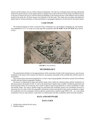
The Technical Institute as an educational foundation has developmental activities such as buildings, laboratories
and many other industrial activities especially that is related to an engineering department like mechanical and machine
departments. At 2014, as a result of the military operation and the terrorists who occupied the city and destroyed all its
020024-2](https://image.slidesharecdn.com/5-230414104500-819afca5/85/5-0000099-pdf-3-320.jpg)
![SOFTWARE USED
1. ARC GIS version.10.3, Arc Map
2. Microsoft Office version 2016
3. Google Earth Pro
4. GPS Receiver Model, Garmin 64S.
FIGURE 2. Research Methodology
DATA COLLECTION
THE DATA USED IN GIS DIVIDED INTO TWO TYPES:
1. Spatial data that are meaning features coordinate or location of any feature represented on the satellite image. The
satellite image is simply a picture taken by satellite to observe the earth’s surface, the satellite image has some elements
such as shape, location, size and color that is very useful for visual interpretation.
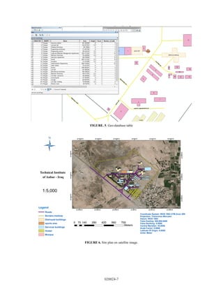
2. Attribute data is qualitative data that can be enumerated for recording and analysis. It’s simply characteristic for
feature and linked within the digital map as a file called geodatabase, every feature taken specific value as encoding,
its simply give information for spatial data.
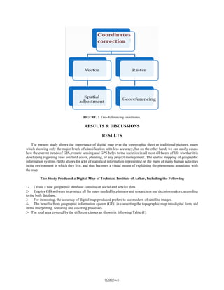
DIGITIZING
The digitization refers to conversion from digital raster image to digital vector data, which is often called raster to
vector (R2V) conversion. Vectorization is not very easy as compared with rasterization, because vector format requires
topological structure. The raster images which are displayed on a computer screen are traced with the vector
point/line/polygon in different data layers. The Advantage of this process is zooming facility gives higher accuracy,
image processing techniques can be applied on the raster images to remove the errors or enhance the image [8]. The
vector data (point / line / polygon) are assigned to the geographic identifiers (geographic coordinates), which called
Geo-coding process that is generating points from a textual table in with at least two fields contain longitudinal and
latitudinal coordinates and this is a simple method of geocoding. By using vector points and textual coordinates to plot
the locations on the map. This method helps to create very precise cartographic definitions of property. In Fig 3 the
geo-referencing process of how to rectify satellite image according to the corrected coordinates.
020024-4](https://image.slidesharecdn.com/5-230414104500-819afca5/85/5-0000099-pdf-5-320.jpg)